
.gif)
Hurricane Nicole (1998)
Encyclopedia
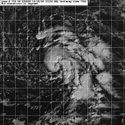
Hurricane Nicole was the last hurricane in the 1998 Atlantic hurricane season
. It developed from a frontal low to the south of the Azores
on November 24, and quickly strengthened to reach winds of 70 mph (110 km/h) as it moved to the west-southwest. An approaching upper-level trough moved over the system, producing strong wind shear
which rapidly weakened Nicole to a tropical depression. After the trough passed, the system entered an area of lighter shear, and steadily restrengthened. An approaching cold front turned it to the northeast, and while moving over anomalously warm sea surface temperature
s Nicole attained hurricane status. It reached a peak intensity of 85 mph (135 km/h) on December 1, and rapidly weakened over the waters of the north Atlantic Ocean
. Nicole was one of five December Atlantic hurricanes on record.
located several hundred miles south of the Azores
persisted for several days in late November while remaining nearly stationary. After it began moving steadily to the west, a tightly-wrapped band of convection developed near the center, and it is estimated the system developed into Tropical Depression Fourteen on November 24 while located 725 miles (1,165 km) south of Lajes
, Azores. The system quickly intensified as it moved west-southwestward, and strengthened into Tropical Storm Nicole six hours after forming. Tropical Storm Nicole was a small storm, and upon first forming tropical storm force winds extended only 60 miles (95 km) from the center.
A few hours after attaining tropical storm status, a ship just north of the center reported winds of 41 mph (66 km/h), confirming the system was a tropical storm. Located to the south of a strong mid-level ridge
, Nicole continued to the west-southwest while centered within a large upper-level low. Common for late-season development in the subtropics, this produced light vertical shear over the storm. The storm moved through an area of marginal sea surface temperature
s of 77°F (25°C). An intermittent eye feature
of the small area of deep convection, and Nicole quickly strengthened to reach an initial peak intensity of 70 mph (115 km/h). After maintaining its peak for around twelve hours, an upper-level trough
moved rapidly eastward over Nicole, which produced high levels of wind shear. The shear weakened the storm, and by late on November 25 the center became exposed to the west of the diminishing deep convection. The shear dissipated most of the convection, and Nicole degenerated to a tropical depression on November 26. Operationally, advisories were discontinued, and regeneration was considered unlikely.
 The low turned to the west, and following the passage of the trough a ridge became established over Nicole. This resulted in a decrease in wind shear, and deep convection redeveloped over the storm. The National Hurricane Center
reinstated advisories for Nicole on November 27 while located about 1,515 miles (2,440 km) west-southwest of the Canary Islands
. The low-level circulation was initially exposed on the southwest side of the convection, though Nicole quickly strengthened and unexpectedly re-attained tropical storm status later on November 27. Upon reaching tropical storm status for the second time, the center of Nicole moved beneath the convection while an anticyclone
developed over the storm. Banding features began to develop, and outflow was well-defined. An approaching cold front
turned Nicole to the north, and late on November 28 the storm reached its westernmost point while located 1,125 miles (1,800 km) east-northeast of Bermuda
.
After turning to the northeast, shear from the approaching front weakened Nicole slightly, and the center became situated near the western edge of the convection. Upper-level diffluence allowed the convection to persist despite the shearing environment, and an eye-feature developed within the convection. Anomalously warm sea surface temperatures of 3º to 5°F (2º to 3°C) above normal allowed the storm to continue strengthening, and early on November 30 Nicole strengthened to attain hurricane status while located 1,280 miles (2,060 km) west-southwest of Lajes, Azores. A nearly complete eyewall organized within the storm, and early on December 1 Nicole reached a peak intensity of 85 mph (135 km/h). It turned northward and rapidly weakened, and Nicole became extratropical later on December 1 while located 285 miles (460 km) northwest of the Azores. The extratropical remnant turned to the northwest while moving around the periphery of a larger circulation, and on December 2 Nicole dissipated.
When Nicole lasted into December as a hurricane, it was one of only five Atlantic hurricanes on record in the month. The other five attained the intensity during the month, and included an unnamed hurricane in the 1887 season, Hurricane Alice in 1954, Hurricane Lili
in 1984, and Hurricane Epsilon in 2005.
1998 Atlantic hurricane season
The 1998 Atlantic hurricane season officially began on June 1, 1998, and lasted until November 30, 1998. These dates conventionally delimit the period of each year when most tropical cyclones form in the Atlantic basin; however, the season extended through December 1 as Hurricane Nicole remained...
. It developed from a frontal low to the south of the Azores
Azores
The Archipelago of the Azores is composed of nine volcanic islands situated in the middle of the North Atlantic Ocean, and is located about west from Lisbon and about east from the east coast of North America. The islands, and their economic exclusion zone, form the Autonomous Region of the...
on November 24, and quickly strengthened to reach winds of 70 mph (110 km/h) as it moved to the west-southwest. An approaching upper-level trough moved over the system, producing strong wind shear
Wind shear
Wind shear, sometimes referred to as windshear or wind gradient, is a difference in wind speed and direction over a relatively short distance in the atmosphere...
which rapidly weakened Nicole to a tropical depression. After the trough passed, the system entered an area of lighter shear, and steadily restrengthened. An approaching cold front turned it to the northeast, and while moving over anomalously warm sea surface temperature
Sea surface temperature
Sea surface temperature is the water temperature close to the oceans surface. The exact meaning of surface varies according to the measurement method used, but it is between and below the sea surface. Air masses in the Earth's atmosphere are highly modified by sea surface temperatures within a...
s Nicole attained hurricane status. It reached a peak intensity of 85 mph (135 km/h) on December 1, and rapidly weakened over the waters of the north Atlantic Ocean
Atlantic Ocean
The Atlantic Ocean is the second-largest of the world's oceanic divisions. With a total area of about , it covers approximately 20% of the Earth's surface and about 26% of its water surface area...
. Nicole was one of five December Atlantic hurricanes on record.
Origins
A strong frontal lowSurface weather analysis
Surface weather analysis is a special type of weather map that provides a view of weather elements over a geographical area at a specified time based on information from ground-based weather stations...
located several hundred miles south of the Azores
Azores
The Archipelago of the Azores is composed of nine volcanic islands situated in the middle of the North Atlantic Ocean, and is located about west from Lisbon and about east from the east coast of North America. The islands, and their economic exclusion zone, form the Autonomous Region of the...
persisted for several days in late November while remaining nearly stationary. After it began moving steadily to the west, a tightly-wrapped band of convection developed near the center, and it is estimated the system developed into Tropical Depression Fourteen on November 24 while located 725 miles (1,165 km) south of Lajes
Lajes (Praia da Vitória)
Lajes is a civil parish in the municipality of Praia da Vitória, on the island of Terceira in the Portuguese Azores. In 2001, the population was 3753, occupying an area of 12.11 km², in the north-eastern coast of the municipality : it is the second largest and the most populous parish in the...
, Azores. The system quickly intensified as it moved west-southwestward, and strengthened into Tropical Storm Nicole six hours after forming. Tropical Storm Nicole was a small storm, and upon first forming tropical storm force winds extended only 60 miles (95 km) from the center.
A few hours after attaining tropical storm status, a ship just north of the center reported winds of 41 mph (66 km/h), confirming the system was a tropical storm. Located to the south of a strong mid-level ridge
Ridge (meteorology)
A ridge is an elongated region of relatively high atmospheric pressure, the opposite of a trough....
, Nicole continued to the west-southwest while centered within a large upper-level low. Common for late-season development in the subtropics, this produced light vertical shear over the storm. The storm moved through an area of marginal sea surface temperature
Sea surface temperature
Sea surface temperature is the water temperature close to the oceans surface. The exact meaning of surface varies according to the measurement method used, but it is between and below the sea surface. Air masses in the Earth's atmosphere are highly modified by sea surface temperatures within a...
s of 77°F (25°C). An intermittent eye feature
Eye (cyclone)
The eye is a region of mostly calm weather found at the center of strong tropical cyclones. The eye of a storm is a roughly circular area and typically 30–65 km in diameter. It is surrounded by the eyewall, a ring of towering thunderstorms where the second most severe weather of a cyclone...
of the small area of deep convection, and Nicole quickly strengthened to reach an initial peak intensity of 70 mph (115 km/h). After maintaining its peak for around twelve hours, an upper-level trough
Trough (meteorology)
A trough is an elongated region of relatively low atmospheric pressure, often associated with fronts.Unlike fronts, there is not a universal symbol for a trough on a weather chart. The weather charts in some countries or regions mark troughs by a line. In the United States, a trough may be marked...
moved rapidly eastward over Nicole, which produced high levels of wind shear. The shear weakened the storm, and by late on November 25 the center became exposed to the west of the diminishing deep convection. The shear dissipated most of the convection, and Nicole degenerated to a tropical depression on November 26. Operationally, advisories were discontinued, and regeneration was considered unlikely.
Regeneration
National Hurricane Center
The National Hurricane Center , located at Florida International University in Miami, Florida, is the division of the National Weather Service responsible for tracking and predicting weather systems within the tropics between the Prime Meridian and the 140th meridian west poleward to the 30th...
reinstated advisories for Nicole on November 27 while located about 1,515 miles (2,440 km) west-southwest of the Canary Islands
Canary Islands
The Canary Islands , also known as the Canaries , is a Spanish archipelago located just off the northwest coast of mainland Africa, 100 km west of the border between Morocco and the Western Sahara. The Canaries are a Spanish autonomous community and an outermost region of the European Union...
. The low-level circulation was initially exposed on the southwest side of the convection, though Nicole quickly strengthened and unexpectedly re-attained tropical storm status later on November 27. Upon reaching tropical storm status for the second time, the center of Nicole moved beneath the convection while an anticyclone
Anticyclone
An anticyclone is a weather phenomenon defined by the United States' National Weather Service's glossary as "[a] large-scale circulation of winds around a central region of high atmospheric pressure, clockwise in the Northern Hemisphere, counterclockwise in the Southern Hemisphere"...
developed over the storm. Banding features began to develop, and outflow was well-defined. An approaching cold front
Surface weather analysis
Surface weather analysis is a special type of weather map that provides a view of weather elements over a geographical area at a specified time based on information from ground-based weather stations...
turned Nicole to the north, and late on November 28 the storm reached its westernmost point while located 1,125 miles (1,800 km) east-northeast of Bermuda
Bermuda
Bermuda is a British overseas territory in the North Atlantic Ocean. Located off the east coast of the United States, its nearest landmass is Cape Hatteras, North Carolina, about to the west-northwest. It is about south of Halifax, Nova Scotia, Canada, and northeast of Miami, Florida...
.
After turning to the northeast, shear from the approaching front weakened Nicole slightly, and the center became situated near the western edge of the convection. Upper-level diffluence allowed the convection to persist despite the shearing environment, and an eye-feature developed within the convection. Anomalously warm sea surface temperatures of 3º to 5°F (2º to 3°C) above normal allowed the storm to continue strengthening, and early on November 30 Nicole strengthened to attain hurricane status while located 1,280 miles (2,060 km) west-southwest of Lajes, Azores. A nearly complete eyewall organized within the storm, and early on December 1 Nicole reached a peak intensity of 85 mph (135 km/h). It turned northward and rapidly weakened, and Nicole became extratropical later on December 1 while located 285 miles (460 km) northwest of the Azores. The extratropical remnant turned to the northwest while moving around the periphery of a larger circulation, and on December 2 Nicole dissipated.
When Nicole lasted into December as a hurricane, it was one of only five Atlantic hurricanes on record in the month. The other five attained the intensity during the month, and included an unnamed hurricane in the 1887 season, Hurricane Alice in 1954, Hurricane Lili
Hurricane Lili (1984)
Hurricane Lili was one of only five Atlantic tropical cyclones on record to reach hurricane status in the month of December. The final of thirteen tropical storms in the 1984 Atlantic hurricane season, Lili developed as a subtropical cyclone which originated from a frontal trough to the south of...
in 1984, and Hurricane Epsilon in 2005.
Impact
Nicole remained hundreds of miles away from land throughout its entire lifetime, and as a result it caused no damage or deaths.See also
- Other storms of the same name