
Houhora
Encyclopedia


Aupouri Peninsula
The Aupouri Peninsula is a tombolo at the northern tip of the North Island of New Zealand. It projects between the Tasman Sea to the west and the Pacific Ocean to the east...
of Northland, New Zealand
New Zealand
New Zealand is an island country in the south-western Pacific Ocean comprising two main landmasses and numerous smaller islands. The country is situated some east of Australia across the Tasman Sea, and roughly south of the Pacific island nations of New Caledonia, Fiji, and Tonga...
. It is 41 km (25.5 mi) north of Kaitaia
Kaitaia
Kaitaia is a town in the far north region of New Zealand, at the base of the Aupouri Peninsula which is about 160 km northwest of Whangarei. It is the last major settlement on the main road north to the capes and bays on the peninsula...
. Waihopo, Te Raupo, Pukenui, Raio and Houhora Heads are associated localities on the southern shores of the harbour. State Highway 1
State Highway 1 (New Zealand)
State Highway 1 is the longest and most significant road in the New Zealand roading network, running the length of both main islands. It appears on road maps as SH 1 and on road signs as a white number 1 on a red shield, but it has the official designations SH 1N in the North Island, SH 1S in the...
passes through all these localities except for Houhora Heads. Te Kao
Te Kao
Te Kao is a district on the Aupouri Peninsula of Northland, New Zealand. State Highway 1 passes through the district. Cape Reinga is 46 km to the north, and Houhora is 24 km to the south...
is 24 km north west, and Waiharara
Waiharara
Waiharara is a community at the base of the Aupouri Peninsula in Northland, New Zealand. State Highway 1 runs through the community. To the west is Aupouri Forest, and beyond that Ninety Mile Beach. To the east is Rangaunu Harbour. Houhora is 22 km north west, and Awanui is 16 km south east...
is 22 km south east.
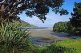
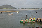
The harbour is long and narrow, mostly sheltered but with exposed sand banks at low tide. There is a deep channel along the southern shore as far as Pukenui Wharf. Mt Camel (also called Mt Houhora) is a 236 metre hill forming the North Head. The South Head is a flat area.
The population was 837 in the 2006 Census, a decrease of 78 from 2001.
History
Houhora Mountain was the first part of New Zealand that the early explorer KupeKupe
In the Māori mythology of some tribes, Kupe was involved in the Polynesian discovery of New Zealand.-Contention:There is contention concerning the status of Kupe. The contention turns on the authenticity of later versions of the legends, the so-called 'orthodox' versions closely associated with S....
saw, but he thought it was a whale, according to Māori legend. Houhora was a Māori base settlement in the early 14th century. Snapper, seals, dolphins, moa and other birds were food sources.
James Cook
James Cook
Captain James Cook, FRS, RN was a British explorer, navigator and cartographer who ultimately rose to the rank of captain in the Royal Navy...
named Mt Camel, on the north head of Houhora Harbour, on 10 December 1769. He described it in his log as "a high mountain or hill standing upon a desert shore."
Te Houtaewa was a Te Aupōuri
Te Aupouri
Te Aupōuri is the northernmost Māori iwi , located north of Kaitaia, Northland, New Zealand, a region known as the Aupouri Peninsula.-The ancestral legend:...
athlete, who was killed at Pukenui during the Musket Wars
Musket Wars
The Musket Wars were a series of five hundred or more battles mainly fought between various hapū , sometimes alliances of pan-hapū groups and less often larger iwi of Māori between 1807 and 1842, in New Zealand.Northern tribes such as the rivals Ngāpuhi and Ngāti Whātua were the first to obtain...
of the early 19th century.
Hone Heke
Hone Heke
Hone Wiremu Heke Pokai was a Māori rangatira and war leader in Northern New Zealand and a nephew of Hongi Hika, an earlier war leader of the Ngāpuhi iwi. Hone Heke is considered the principal instigator of the Flagstaff War....
was defeated by Tāmati Wāka Nene
Tamati Waka Nene
Tāmati Wāka Nene was a Māori rangatira who fought as an ally of the British in the Flagstaff War.-Origin and mana:...
in the Battle of Te Ahuahu at Pukenui on 12 June 1845.
In the 19th century, Houhora Harbour provisioned whaler
Whaler
A whaler is a specialized ship, designed for whaling, the catching and/or processing of whales. The former included the whale catcher, a steam or diesel-driven vessel with a harpoon gun mounted at its bows. The latter included such vessels as the sail or steam-driven whaleship of the 16th to early...
s, and residents mounted their own whaling expeditions in open boats. Three families - Wagener, Subritzky and Yates - settled in the area to farm and trade. The Subritzky family, who arrived near Motueka
Motueka
The town of Motueka in the South Island of New Zealand lies close to the mouth of the Motueka River, on the western shore of Tasman Bay. It is, after Nelson and Richmond, the third largest centre in the Tasman Region, with a population of 7125...
in 1843, claim to be New Zealand's first Polish settlers. They moved to Australia and then to Houhora Heads. Their homestead there took two years to build in the 1860s. It was sold to a member of the Wagener family in 1897.
A lifeboat from Elingamite, which was wrecked on the Three Kings Islands
Three Kings Islands
The Three Kings Islands or Manawa Islands are a group of 13 islands about northwest of Cape Reinga, the northernmost point of the North Island of New Zealand, where the South Pacific Ocean and Tasman Sea converge. They measure about 4.86 km² in area...
on 9 November 1902, arrived in Houhora the following day with 52 survivors. One of the whalers immediately was dispatched to intercept any vessel along to coast to divert it to the Three Kings. This mission was successful.
Notable people
- Lloyd Allan TriggLloyd Allan TriggFlying Officer Lloyd Allan Trigg VC DFC , of Houhora, New Zealand, was a pilot in the RNZAF. He was a posthumous recipient of the Victoria Cross, the highest award for gallantry in the face of the enemy for British and Commonwealth armed forces...
, a pilot in the RNZAFRoyal New Zealand Air ForceThe Royal New Zealand Air Force is the air arm of the New Zealand Defence Force...
during World War IIWorld War IIWorld War II, or the Second World War , was a global conflict lasting from 1939 to 1945, involving most of the world's nations—including all of the great powers—eventually forming two opposing military alliances: the Allies and the Axis...
, and Victoria CrossVictoria CrossThe Victoria Cross is the highest military decoration awarded for valour "in the face of the enemy" to members of the armed forces of various Commonwealth countries, and previous British Empire territories....
recipient.
Education
Pukenui School is a coeducational full primary (years 1-8) school with a decile ratingSocio-Economic Decile
Decile, Socio-Economic Decile or Socio-Economic Decile Band is a widely used measure in education in New Zealand used to target funding and support to more needy schools....
of 3 and a roll of 75.