
Horowhenua District
Encyclopedia
| Horowhenua District | |
 |
|
| Population: | (territorial) |
| Main town: | Levin Levin, New Zealand Levin is a town in the Manawatu-Wanganui region of New Zealand, and is the largest town in the Horowhenua district. It is 90 kilometres north of Wellington, 50 kilometres south of Palmerston North, and two kilometres to the east of Lake Horowhenua.... |
| Other towns: | Foxton, Foxton Beach, Shannon, Tokomaru |
| Territorial Authority | |
|---|---|
| Name: | Horowhenua District Council |
| Mayor: | Brendan Duffy |
| Land area: | 1,063.60 km² (410.66 sq mi) |
| Extent: | NW to Foxton, N to Tokomaru and Shannon; W to Tasman Sea; S to Kapiti Coast District & SE to Tararua Ranges |
| Website: | http://www.horowhenua.govt.nz/ |
| See also: | Manawatu District, Palmerston North Palmerston North Palmerston North is the main city of the Manawatu-Wanganui region of the North Island of New Zealand. It is an inland city with a population of and is the country's seventh largest city and eighth largest urban area. Palmerston North is located in the eastern Manawatu Plains near the north bank... |
| Regional Council | |
| Name: | Manawatu-Wanganui Manawatu-Wanganui Manawatu-Wanganui is a region in the lower half of the North Island of New Zealand, around the cities of Palmerston North and Whanganui. It is administered by the Horizons Regional Council.-Administration:... (Horizons Regional Council) |
| Website: | http://www.horizons.govt.nz/ |
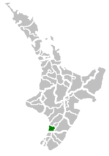
Horowhenua is a district
Territorial authorities of New Zealand
Territorial authorities are the second tier of local government in New Zealand, below regional councils. There are 67 territorial authorities: 13 city councils, 53 district councils, and the Chatham Islands Council...
on the west coast of the North Island
North Island
The North Island is one of the two main islands of New Zealand, separated from the much less populous South Island by Cook Strait. The island is in area, making it the world's 14th-largest island...
of New Zealand
New Zealand
New Zealand is an island country in the south-western Pacific Ocean comprising two main landmasses and numerous smaller islands. The country is situated some east of Australia across the Tasman Sea, and roughly south of the Pacific island nations of New Caledonia, Fiji, and Tonga...
. It forms part of the Manawatu-Wanganui Region.
Located north of Wellington
Wellington
Wellington is the capital city and third most populous urban area of New Zealand, although it is likely to have surpassed Christchurch due to the exodus following the Canterbury Earthquake. It is at the southwestern tip of the North Island, between Cook Strait and the Rimutaka Range...
and Kapiti
Kapiti Coast District
The Kapiti Coast District is a local government district in the lower North Island of New Zealand 50 km north of Wellington.The district is named after Kapiti Island a prominent landmark 5 km offshore. The population of the district is concentrated in the chain of coastal settlements...
, the district stretches from slightly north of the town of Otaki
Otaki, New Zealand
Otaki is a town in the Kapiti Coast District of the North Island of New Zealand, situated half way between the capital city Wellington, 70 kilometres to the southwest, and Palmerston North, 70 kilometres to the northeast. It marks the northernmost point of the Wellington Region. The town's...
in the south to just south of Himatangi
Himatangi
Himatangi, formerly Carnarvon, is a small settlement in the Manawatu-Wanganui region of New Zealand's North Island. It is located at the junction of State Highways 1 and 56, 25 kilometres west of Palmerston North, and seven kilometres east of the coastal settlement of Himatangi Beach...
in the north, and from the coast to the summit of the Tararua Ranges.
The main town and seat of the district council is Levin
Levin, New Zealand
Levin is a town in the Manawatu-Wanganui region of New Zealand, and is the largest town in the Horowhenua district. It is 90 kilometres north of Wellington, 50 kilometres south of Palmerston North, and two kilometres to the east of Lake Horowhenua....
, and other towns in the district include Foxton
Foxton, New Zealand
Foxton is a town in the Manawatu-Wanganui region of New Zealand. The 2006 census population was 2715.It is located on the lower west coast of the North Island, in the Horowhenua district, 30 kilometres southwest of Palmerston North and 15 kilometres north of Levin. The town is located close to the...
, Shannon
Shannon, New Zealand
Shannon is a small town in the Horowhenua District of New Zealand's North Island. it is located 28 kilometres southwest of Palmerston North and 15 kilometres northeast of Levin. The town's population at the 2006 census was 1506....
, and Tokomaru. The population of the district is
Wards of Horowhenua District
- Levin Ward
- Waiopehu Ward
- Miranui Ward
- Kere Kere Ward
Much of the area was once an extensive wetland and the centre of a substantial flax industry. It has been progressively drained and converted to productive but flood-prone farmland, with a mixture of loam
Loam
Loam is soil composed of sand, silt, and clay in relatively even concentration . Loam soils generally contain more nutrients and humus than sandy soils, have better infiltration and drainage than silty soils, and are easier to till than clay soils...
and peat
Peat
Peat is an accumulation of partially decayed vegetation matter or histosol. Peat forms in wetland bogs, moors, muskegs, pocosins, mires, and peat swamp forests. Peat is harvested as an important source of fuel in certain parts of the world...
based soils. Some parts of the wetland, particularly those around Lake Horowhenua
Lake Horowhenua
Lake Horowhenua is located in the Horowhenua, an area of the southern Manawatu-Wanganui region in New Zealand's North Island. It covers an area of 3.9 square kilometres....
are being returned to their former state as a conservation area, with the help of local Māori.
Foxton is of historical note as the main town in Manawatu in the early years of European colonisation, and the centre of a large flax
New Zealand flax
New Zealand flax describes common New Zealand perennial plants Phormium tenax and Phormium cookianum, known by the Māori names harakeke and wharariki respectively...
industry. Horticulture and dairying are now the main forms of primary industry in the district, and secondary industries in Horowhenua include manufacturing (especially clothing manufacture) and food processing.
Schools in Horowhenua District
Secondary- Manawatu CollegeManawatu CollegeManawatu College is a high school in Foxton, New Zealand. It is a co-educational school.-House system:Each student belongs to a 'house group'...
, Foxton - Horowhenua College, Levin
- Waiopehu College, Levin
Primary
- Foxton Beach School, Foxton Beach
- Coley Street School, Foxton
- Foxton Primary, Foxton
- St. Marys, Foxton
- Levin East School, Levin
- Fairfield School, Levin
- Ohau School, Ohau (Levin Rural)
- Koputuroa School, Levin Rural
- St. Josephs, Levin
- Levin School, Levin
- Levin North School, Levin
- Taitoko School, Levin
- Poroutawhao School, Levin Rural
- Shannon School, Shannon
- Manakau School, Manakau
- Opiki School, Opiki
- Tokomaru School, Tokomaru
Intermediate
- Levin Intermediate, Levin (Year 7&8's only)
Artesian water
Much use is made of artesianArtesian aquifer
An artesian aquifer is a confined aquifer containing groundwater under positive pressure. This causes the water level in a well to rise to a point where hydrostatic equilibrium has been reached. This type of well is called an artesian well...
water supplies. The northern part of the district, around Opiki
Opiki
Opiki is a small rural settlement in the Horowhenua district of New Zealand's North Island. It is located on the floodplain of the Manawatu River, 15 kilometres southwest of Palmerston North. Its population is 351....
, is situated above a series of aquifer
Aquifer
An aquifer is a wet underground layer of water-bearing permeable rock or unconsolidated materials from which groundwater can be usefully extracted using a water well. The study of water flow in aquifers and the characterization of aquifers is called hydrogeology...
s. These are vertically separated from each other by layers of less permeable
Permeability (fluid)
Permeability in fluid mechanics and the earth sciences is a measure of the ability of a porous material to allow fluids to pass through it.- Units :...
material, known as aquicludes. Within each aquifer, there may also be pockets of less permeable material, known as lenses. In descending order, the aquifers below the Opiki district are the Foxton, the Himatangi, and the Opiki Aquifers. Over its whole extent, which is much wider than the Opiki area, the Foxton Aquifer lies mostly between 30 m and 60 m below ground level. Around Opiki it is shallower, generally between 24 m and 35 m below ground.
Although not unique, the Foxton Aquifer in this area has the relatively uncommon quality of being under pressure so that when a bore is tapped into it, the water rises under its own pressure and will flow above ground; i.e. there is flowing artesian
Artesian aquifer
An artesian aquifer is a confined aquifer containing groundwater under positive pressure. This causes the water level in a well to rise to a point where hydrostatic equilibrium has been reached. This type of well is called an artesian well...
water. The head varies with ground level but can be as high as about 2.5 m above ground level. The level to which it will rise defines the potentiometric surface
Potentiometric surface
A potentiometric surface is based on hydraulic principles. For example, we know that two connected storage tanks with one full and one empty will gradually fill/drain to the same level. This is because of atmospheric pressure and gravity. A potentiometric surface is the imaginary line where a given...
. For obvious reasons, the farmers and residential users who have bores tapping into the Foxton Aquifer regard this as a most useful attribute. In many cases it can avoid the necessity of pumping water from the bore and, for those even more fortunate, it can avoid the necessity of reticulating the water around farm properties by pumping systems. There are natural seasonal fluctuations in levels and pressures, but there is evidence that, even in times of extended dry periods, no property in the area loses positive pressure entirely, although some decline to a critical point. As an aside to that point, it is inevitable that the existing bores in the area will have reduced the potentiometric surface from its original level, and that future permitted bores will continue that trend. There must come a time when those properties which now become critical at those times will lose flowing artesian water.
Sport
In rugby, a combined Horowhenua-Kapiti teamHorowhenua-Kapiti Rugby Football Union
-Representative Rugby:The Horowhenua-Kapiti team play from Levin Domain, Levin and in the 2006 season are in Pool B of the Heartland Championship. They are seeded 6th qualifiers for the Championship as they were runner-ups in the 3rd division in 2005....
represents the area in the amateur Heartland Championship
Heartland Championship
The Heartland Championship New Zealand Division One competition, known for sponsorship reasons as the AA Rewards Heartland Championship, is a domestic rugby union competition in New Zealand. It was founded in 2006 as one of two successor competitions to the country's former domestic competition,...
.