

Kapiti Coast District
Encyclopedia
| Kapiti Coast District | |
 |
|
| Population: | |
| Main town: | Paraparaumu Paraparaumu Paraparaumu is a town in the south-western North Island of New Zealand. It lies in the Kapiti Coast, 50 kilometres north of the nation's capital city, Wellington.... |
| Other towns: | Otaki, Raumati, Raumati Beach, Paraparaumu Beach, Manakau, Paekakariki, Waikanae |
| Territorial Authority | |
|---|---|
| Name: | Kapiti Coast District Council |
| Mayor: | Jenny Rowan |
| Extent: | Paekakariki to Otaki;east to the Tararuas |
| Land Area: | 731.25 km² (282.34 sq mi) |
| Website: | http://www.kapiticoast.govt.nz |
| See also: | Masterton Masterton Masterton is a large town and local government district in the Wellington Region of New Zealand. It is the largest town in the Wairarapa, a region separated from Wellington by the Rimutaka ranges... , Wellington Wellington Wellington is the capital city and third most populous urban area of New Zealand, although it is likely to have surpassed Christchurch due to the exodus following the Canterbury Earthquake. It is at the southwestern tip of the North Island, between Cook Strait and the Rimutaka Range... |
| Regional Council | |
| Name: | Greater Wellington Wellington Wellington is the capital city and third most populous urban area of New Zealand, although it is likely to have surpassed Christchurch due to the exodus following the Canterbury Earthquake. It is at the southwestern tip of the North Island, between Cook Strait and the Rimutaka Range... |
| Website: | http://www.gw.govt.nz |
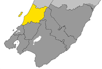
The Kapiti Coast District is a local government district
Territorial authorities of New Zealand
Territorial authorities are the second tier of local government in New Zealand, below regional councils. There are 67 territorial authorities: 13 city councils, 53 district councils, and the Chatham Islands Council...
in the lower North Island of New Zealand 50 km north of Wellington.
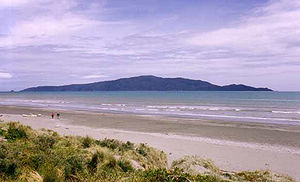
The district is named after Kapiti Island
Kapiti Island
-External links:* , Department of Conservation* * , Nature Coast Enterprise *...
a prominent landmark 5 km offshore. The population of the district is concentrated in the chain of coastal settlements along State Highway One: Otaki
Otaki, New Zealand
Otaki is a town in the Kapiti Coast District of the North Island of New Zealand, situated half way between the capital city Wellington, 70 kilometres to the southwest, and Palmerston North, 70 kilometres to the northeast. It marks the northernmost point of the Wellington Region. The town's...
, Te Horo
Te Horo
Te Horo and Te Horo Beach are two localities on the Kapiti Coast of New Zealand's North Island. Te Horo Beach is the larger of the two settlements and, as its name implies, is located on the Tasman Sea coast. Te Horo is located to the east, a short distance inland. They are situated between Peka...
, Waikanae
Waikanae
Waikanae is a small town on New Zealand's Kapiti Coast. The name is a Māori word meaning "The waters of the yellow eyed mullet". Another settlement called Waikanae Beach exists near Gisborne on the east coast of the North Island of New Zealand....
, Paraparaumu
Paraparaumu
Paraparaumu is a town in the south-western North Island of New Zealand. It lies in the Kapiti Coast, 50 kilometres north of the nation's capital city, Wellington....
, Raumati
Raumati
Raumati collectively refers to two neighbouring places on the Kapiti Coast of New Zealand's North Island. They are located 50-60 km north-east of Wellington, and immediately to the south-west of the larger town of Paraparaumu. The Maungakotukutuku area is located immediately behind Raumati...
and Paekakariki
Paekakariki
Paekakariki is a town in the Kapiti Coast District in the south-western North Island of New Zealand. It is 22 km north of Porirua and 45 km north-east of Wellington, the nation's capital city....
. Paraparaumu is the most populous settlement and the commercial and administrative centre. Much of the rural land is given over to horticulture and market gardens are common along the highway between the settlements. Paraparumu has a small airport with daily scheduled flights across Cook Strait
Cook Strait
Cook Strait is the strait between the North and South Islands of New Zealand. It connects the Tasman Sea on the west with the South Pacific Ocean on the east....
to Nelson
Nelson, New Zealand
Nelson is a city on the eastern shores of Tasman Bay, and is the economic and cultural centre of the Nelson-Tasman region. Established in 1841, it is the second oldest settled city in New Zealand and the oldest in the South Island....
and Blenheim
Blenheim, New Zealand
Blenheim is the most populous town in the region of Marlborough, in the north east of the South Island of New Zealand, and the seat of the regional council. It has a population of The area which surrounds the town is well known as a centre of New Zealand's wine industry...
.
The area available for agriculture and settlement is narrow and coastal. Much of the eastern part of the district is part of the Tararua Forest Park which covers the rugged Tararua Range with peaks rising to over 1500 m.
Administration
The district is administered by the Kapiti Coast District Council, a local body elected by residents every three years. The council consists of a mayor and 10 councillors. Residents also elect a community board for their local area. There are four of these, each with four members: Otaki, Waikanae, Paraparaumu/Raumati and Paekakariki. The Wellington Regional CouncilWellington Region
The Wellington region of New Zealand occupies the southern end of the North Island.-Governance:The official Wellington Region, as administered by the Wellington Regional Council covers the conurbation around the capital city, Wellington, and the cities of Lower Hutt, Porirua, and Upper Hutt, each...
(branded as Greater Wellington) is responsible for regional governance of the district including public transport, water and environmental management.
Features
Paraparaumu Airport
Kapiti Coast Airport , earlier called Paraparaumu Airport, is on the Kapiti Coast of New Zealand's North Island, between the Wellington dormitory suburbs of Paraparaumu Beach , Paraparaumu to the east, and Raumati Beach to the south...
and Queen Elizabeth Park. The airport is sandwiched between Paraparaumu (to the north) and Raumati (to the south). Possessing three runways (one of which is now closed), it once served as the main airport of the Wellington region, but is now used mainly by aeroclubs. The park, lying to the south of Raumati, is a popular attraction which covers some 12 km². The park extends to Paekakariki, and houses the Wellington Tramway Museum
Wellington Tramway Museum
The Wellington Tramway Museum is at Queen Elizabeth Park in New Zealand, near the overbridge at MacKays Crossing between Paekakariki and Paraparaumu, and has been operating trams there since 1965...
.
Other tourist attractions on the Kapiti Coast include Paraparaumu Golf Course. Another attraction a few kilometres north of the town centre is the Southward Car Museum
Southward Car Museum
The Southward Car Museum is an automobile museum housing a collection of over 250 vehicles, as well as three aircraft, located on Otaihanga Road, Otaihanga, just north of Paraparaumu on the Kapiti Coast of New Zealand's North Island...
in Otaihanga.
The district is on the North Island Main Trunk railway line (NIMT), and is served by suburban passenger trains referred to as the Kapiti Line.
Population
Although administratively part of the Wellington RegionWellington Region
The Wellington region of New Zealand occupies the southern end of the North Island.-Governance:The official Wellington Region, as administered by the Wellington Regional Council covers the conurbation around the capital city, Wellington, and the cities of Lower Hutt, Porirua, and Upper Hutt, each...
, it is to a large extent socially distinct from Wellington
Wellington
Wellington is the capital city and third most populous urban area of New Zealand, although it is likely to have surpassed Christchurch due to the exodus following the Canterbury Earthquake. It is at the southwestern tip of the North Island, between Cook Strait and the Rimutaka Range...
and the Hutt Valley, which together comprise the nucleus of the region. However many residents travel into Wellington each day for work and the whole Kapiti Coast is a popular weekend destination for the people of the Wellington Region. Many migrate to the area for their retirement. The Kapiti Coast district incorporates such towns as Paekakariki
Paekakariki
Paekakariki is a town in the Kapiti Coast District in the south-western North Island of New Zealand. It is 22 km north of Porirua and 45 km north-east of Wellington, the nation's capital city....
, Raumati
Raumati
Raumati collectively refers to two neighbouring places on the Kapiti Coast of New Zealand's North Island. They are located 50-60 km north-east of Wellington, and immediately to the south-west of the larger town of Paraparaumu. The Maungakotukutuku area is located immediately behind Raumati...
, Paraparaumu
Paraparaumu
Paraparaumu is a town in the south-western North Island of New Zealand. It lies in the Kapiti Coast, 50 kilometres north of the nation's capital city, Wellington....
, Waikanae
Waikanae
Waikanae is a small town on New Zealand's Kapiti Coast. The name is a Māori word meaning "The waters of the yellow eyed mullet". Another settlement called Waikanae Beach exists near Gisborne on the east coast of the North Island of New Zealand....
and Otaki
Otaki, New Zealand
Otaki is a town in the Kapiti Coast District of the North Island of New Zealand, situated half way between the capital city Wellington, 70 kilometres to the southwest, and Palmerston North, 70 kilometres to the northeast. It marks the northernmost point of the Wellington Region. The town's...
, and smaller localities such as Maungakotukutuku
Maungakotukutuku
Maungakotukutuku is a rural locality on the Kapiti Coast of New Zealand's North Island. It is located inland, behind Paraparaumu and Raumati, and the 2001 New Zealand Census of Population and Dwellings gave its population as 621 people, an increase of 38.9% or 174 people since the 1996 census.The...
, Otaihanga
Otaihanga
Otaihanga is on the Kapiti Coast of New Zealand's North Island. It is just north of Paraparaumu on the south bank of the Waikanae River and is roughly 55 km north of New Zealand's capital city, Wellington...
, Peka Peka
Peka Peka
Peka Peka, sometimes Pekapeka, is a lightly populated seaside locality on the Kapiti Coast of New Zealand's North Island. Its population according to the 2001 New Zealand Census of Population and Dwellings is 195, an increase of 35.4% or 51 people since the 1996 census. It is located just off...
, and Te Horo
Te Horo
Te Horo and Te Horo Beach are two localities on the Kapiti Coast of New Zealand's North Island. Te Horo Beach is the larger of the two settlements and, as its name implies, is located on the Tasman Sea coast. Te Horo is located to the east, a short distance inland. They are situated between Peka...
. Paraparaumu, considered the pivot of the district, is located about 55 km north of Wellington.
Relationship with Wellington
Many Kapiti Coast District residents work in Wellington. Commuters to the four cities of Wellington make up 36% of the workforce of the Kapiti Urban Area (Paraparaumu, Waikanae, Paekakariki) and 12% of the workforce of Otaki.http://www.stats.govt.nz/Publications/PopulationStatistics/commuting-patterns-in-nz-1996-2006/commuting-patterns-in-wellington.aspx One of Wellington's two main commuter rail links terminates in Waikanae. There are also commuter bus services.State Highway One connects the Kapiti Coast to Wellington. The road is a narrow, coastal highway that is highly congested and has been subject to occasional closure due to land slides. The Transmission Gully Motorway
Transmission Gully Motorway
The Transmission Gully Motorway is a 26 km motorway proposed for Wellington, New Zealand.-Route:It is planned to replace the current State Highway 1 along the coast road between the Kapiti Coast, Pukerua Bay and Porirua...
has long been mooted both as a commuter route and an alternative access to the capital in case of a civil defence emergency. Preliminary work around this project has been completed but full funding as not yet been secured.
The population of the district has grown rapidly since the 1980s, fueled in large part by Wellingtonians moving to the coast to retire. More Kapiti Coasters are over the retirement age than in any other district or city in the country. 23.3% of the district's population is over 65 compared with 9.4% in the four cities of Wellington and 12.1% of New Zealand as a whole. The main reason for this, is that the area is the retirement capital for the Wellington Region. (2006 Census).