
Horace Williams Airport
Encyclopedia
Horace Williams Airport is a public use airport
located one nautical mile (1.85 km) north of the central business district
of Chapel Hill
, a city in Orange County
, North Carolina
, United States
. It is owned by the University of North Carolina at Chapel Hill
. Although most U.S. airports use the same three-letter location identifier
for the FAA
and IATA
, this airport is assigned IGX by the FAA but has no designation from the IATA.
Horace Williams Airport is home to North Carolina's Area Health Education Center (AHEC) program, which flies doctors and medical specialists participating in instructional and outreach programs, serving outlying communities in under-served areas of the state. In addition, some private flights also help bring distant patients to the UNC Hospitals, as well as occasionally serving as rapid air link with hospital helicopter service for time-critical organ transplants.
The airport was part of a large gift of land to the university by professor Horace Williams in the 1930s, and while the professor did not restrict the use of the property to airport use, it has been an airport since 1933. Presidents Ford and George H. Bush received Navy primary flight training at the airport. President Kennedy visited UNC in October, 1961 and arrived and departed via Horace Williams Airport.
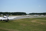
of 512 feet (156 m) above mean sea level. It has one runway
designated 9/27 with an asphalt
surface measuring 4,005 by 75 feet (1,221 x 23 m).
For the 12-month period ending July 31, 2007, the airport had 10,800 aircraft operations, an average of 29 per day: 94% general aviation
, 5% air taxi
and 1% military
. At that time there were 47 aircraft based at this airport: 77% single-engine
and 23% multi-engine.
Carolina North,
a planned major long-term expansion of its campus.
Opposition to closure plans began immediately after the announcement of the planned closure, in 2000 when pilots claimed that closing this air field would be a loss of infrastructure that would never be replaced. They note that upgrades to the airport approved by the FAA have kept pace with current technology and it is staffed with meticulous attention detail and careful people, although there have been some complaints about runway maintenance. The position of general aviation advocates and lobbyists is that there is something very special about airplanes, and to lose them in Chapel Hill for the sake of more buildings, traffic and population density must be carefully considered.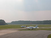 Conflict between the town and airport advocates has had a history dating back to the 1980s, revolving around issues such as the location of the airport in a residential area that includes 4 schools, a church, and a YMCA
, as well as several crashes in the area that eventually resulted in the University's ejection of a flying club flight school from the airport. Critics of the airport noticed that the University's first plans for the Carolina North project included keeping the airport in close proximity to occupied buildings and reminded the University that liability in the event of another crash could be substantial, given the existence of known guidelines recommending against building so close to a working runway. In addition, interested private-industry interests indicated concern about the costs and liabilities of building on the site if the airport remained. The plans for Carolina North were revised, and the UNC Board of Trustees commissioned a study on the basis of which they ordered the airport closed.
The University's plans for airport closure have been blocked in the state legislature on at least three occasions since the 2000 announcement. Although some planes using the airport do so on University business, opposition to closure has historically been offered primarily by private plane owners and general aviation lobbyists desiring to preserve their access to the airport. Most recently, opposition efforts have focused on the University's planned move of six Area Health Education Centers (AHEC) planes to new facilities at Raleigh-Durham International Airport
, to make way for construction of the first phase of the new Carolina North campus project, planned to include teaching, research, and cooperative public-private projects affiliated with the University. However, economic realities stalled all progress on development of Carolina North, and the airport remains open and active.
Airport
An airport is a location where aircraft such as fixed-wing aircraft, helicopters, and blimps take off and land. Aircraft may be stored or maintained at an airport...
located one nautical mile (1.85 km) north of the central business district
Central business district
A central business district is the commercial and often geographic heart of a city. In North America this part of a city is commonly referred to as "downtown" or "city center"...
of Chapel Hill
Chapel Hill, North Carolina
Chapel Hill is a town in Orange County, North Carolina, United States and the home of the University of North Carolina at Chapel Hill and UNC Health Care...
, a city in Orange County
Orange County, North Carolina
Orange County is a county located in the U.S. state of North Carolina. As of the 2010 census, the population was 133,801. Its county seat is Hillsborough...
, North Carolina
North Carolina
North Carolina is a state located in the southeastern United States. The state borders South Carolina and Georgia to the south, Tennessee to the west and Virginia to the north. North Carolina contains 100 counties. Its capital is Raleigh, and its largest city is Charlotte...
, United States
United States
The United States of America is a federal constitutional republic comprising fifty states and a federal district...
. It is owned by the University of North Carolina at Chapel Hill
University of North Carolina at Chapel Hill
The University of North Carolina at Chapel Hill is a public research university located in Chapel Hill, North Carolina, United States...
. Although most U.S. airports use the same three-letter location identifier
Location identifier
A location identifier is a symbolic representation for the name and the location of an airport, navigation aid, or weather station, and is used for manned air traffic control facilities in air traffic control, telecommunications, computer programming, weather reports, and related services.-ICAO...
for the FAA
Federal Aviation Administration
The Federal Aviation Administration is the national aviation authority of the United States. An agency of the United States Department of Transportation, it has authority to regulate and oversee all aspects of civil aviation in the U.S...
and IATA
International Air Transport Association
The International Air Transport Association is an international industry trade group of airlines headquartered in Montreal, Quebec, Canada, where the International Civil Aviation Organization is also headquartered. The executive offices are at the Geneva Airport in SwitzerlandIATA's mission is to...
, this airport is assigned IGX by the FAA but has no designation from the IATA.
Horace Williams Airport is home to North Carolina's Area Health Education Center (AHEC) program, which flies doctors and medical specialists participating in instructional and outreach programs, serving outlying communities in under-served areas of the state. In addition, some private flights also help bring distant patients to the UNC Hospitals, as well as occasionally serving as rapid air link with hospital helicopter service for time-critical organ transplants.
History
Originally known as Martindale Field for Chapel Hill contractor Lee Martindale and one of the first airfields in North Carolina. Then renamed "Chapel Hill Airport" and offered pilot training and air shows. The airport was purchased by the university in 1940 and renamed for Prof. Horace Williams, Chair of Mental and Moral Science (Philosophy) at the University during the first half the twentieth century, who also donated much of the land needed to expand the airport.The airport was part of a large gift of land to the university by professor Horace Williams in the 1930s, and while the professor did not restrict the use of the property to airport use, it has been an airport since 1933. Presidents Ford and George H. Bush received Navy primary flight training at the airport. President Kennedy visited UNC in October, 1961 and arrived and departed via Horace Williams Airport.
Facilities and aircraft
Horace Williams Airport covers an area of 420 acres (170 ha) at an elevationElevation
The elevation of a geographic location is its height above a fixed reference point, most commonly a reference geoid, a mathematical model of the Earth's sea level as an equipotential gravitational surface ....
of 512 feet (156 m) above mean sea level. It has one runway
Runway
According to ICAO a runway is a "defined rectangular area on a land aerodrome prepared for the landing and take-off of aircraft." Runways may be a man-made surface or a natural surface .- Orientation and dimensions :Runways are named by a number between 01 and 36, which is generally one tenth...
designated 9/27 with an asphalt
Asphalt
Asphalt or , also known as bitumen, is a sticky, black and highly viscous liquid or semi-solid that is present in most crude petroleums and in some natural deposits, it is a substance classed as a pitch...
surface measuring 4,005 by 75 feet (1,221 x 23 m).
For the 12-month period ending July 31, 2007, the airport had 10,800 aircraft operations, an average of 29 per day: 94% general aviation
General aviation
General aviation is one of the two categories of civil aviation. It refers to all flights other than military and scheduled airline and regular cargo flights, both private and commercial. General aviation flights range from gliders and powered parachutes to large, non-scheduled cargo jet flights...
, 5% air taxi
Air taxi
An air taxi is an air charter passenger or cargo aircraft which operates on an on-demand basis.-Regulation:In the United States, air taxi and air charter operations are governed by Part 135 of the Federal Aviation Regulations , unlike the larger scheduled air carriers which are governed by more...
and 1% military
Military aviation
Military aviation is the use of aircraft and other flying machines for the purposes of conducting or enabling warfare, including national airlift capacity to provide logistical supply to forces stationed in a theater or along a front. Air power includes the national means of conducting such...
. At that time there were 47 aircraft based at this airport: 77% single-engine
Aircraft engine
An aircraft engine is the component of the propulsion system for an aircraft that generates mechanical power. Aircraft engines are almost always either lightweight piston engines or gas turbines...
and 23% multi-engine.
Safety Incidents
On July 12, 2010, a Cirrus SR 20 carrying Kyle Henn, the brother of a victim of the July 2010 World Cup Finals bombing in Uganda, crashed upon landing at the airport. One person was killed during this crash; Henn survived with non-life threatening injuries, and acted to try to save the crash victim after impact.Closure plans
The University plans to close the airport to make room for construction ofCarolina North,
a planned major long-term expansion of its campus.
Opposition to closure plans began immediately after the announcement of the planned closure, in 2000 when pilots claimed that closing this air field would be a loss of infrastructure that would never be replaced. They note that upgrades to the airport approved by the FAA have kept pace with current technology and it is staffed with meticulous attention detail and careful people, although there have been some complaints about runway maintenance. The position of general aviation advocates and lobbyists is that there is something very special about airplanes, and to lose them in Chapel Hill for the sake of more buildings, traffic and population density must be carefully considered.
YMCA
The Young Men's Christian Association is a worldwide organization of more than 45 million members from 125 national federations affiliated through the World Alliance of YMCAs...
, as well as several crashes in the area that eventually resulted in the University's ejection of a flying club flight school from the airport. Critics of the airport noticed that the University's first plans for the Carolina North project included keeping the airport in close proximity to occupied buildings and reminded the University that liability in the event of another crash could be substantial, given the existence of known guidelines recommending against building so close to a working runway. In addition, interested private-industry interests indicated concern about the costs and liabilities of building on the site if the airport remained. The plans for Carolina North were revised, and the UNC Board of Trustees commissioned a study on the basis of which they ordered the airport closed.
The University's plans for airport closure have been blocked in the state legislature on at least three occasions since the 2000 announcement. Although some planes using the airport do so on University business, opposition to closure has historically been offered primarily by private plane owners and general aviation lobbyists desiring to preserve their access to the airport. Most recently, opposition efforts have focused on the University's planned move of six Area Health Education Centers (AHEC) planes to new facilities at Raleigh-Durham International Airport
Raleigh-Durham International Airport
Raleigh-Durham International Airport is a public international airport located 4.5 miles northeast of the town of Morrisville in suburban Wake County, North Carolina, United States. The airport covers and operates three runways, providing direct service to 40 domestic and international...
, to make way for construction of the first phase of the new Carolina North campus project, planned to include teaching, research, and cooperative public-private projects affiliated with the University. However, economic realities stalled all progress on development of Carolina North, and the airport remains open and active.
External links
- Horace Williams Airport
- Aerial photo as of 2 April 1998 from USGS The National Map