
Holtun
Encyclopedia
Maya civilization
The Maya is a Mesoamerican civilization, noted for the only known fully developed written language of the pre-Columbian Americas, as well as for its art, architecture, and mathematical and astronomical systems. Initially established during the Pre-Classic period The Maya is a Mesoamerican...
archaeological site located in the Petén Department of northern Guatemala
Guatemala
Guatemala is a country in Central America bordered by Mexico to the north and west, the Pacific Ocean to the southwest, Belize to the northeast, the Caribbean to the east, and Honduras and El Salvador to the southeast...
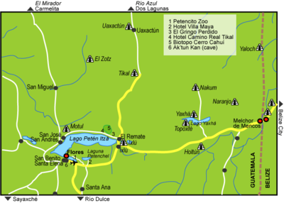
on the road to Melchor de Mencos
Melchor de Mencos
Melchor de Mencos is a municipality in the Petén department of Guatemala with population 23,813. It is situated on the western border with Belize,a and is the only major border crossing from Guatemala to Belize....
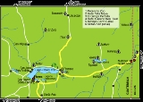
from Flores
Flores, El Petén
Flores is the capital city of Petén department of Guatemala. It is located at . The population is 13,700 .Flores serves as the municipal seat for the surrounding municipality, with which it shares a name ....
. The city had a long period of occupation that lasted from the Middle Preclassic
Mesoamerican chronology
Mesoamerican chronology divides the history of pre-Columbian Mesoamerica into several periods: the Paleo-Indian , the Archaic , the Preclassic , the Classic , and the Postclassic...
through to the Late Classic
Mesoamerican chronology
Mesoamerican chronology divides the history of pre-Columbian Mesoamerica into several periods: the Paleo-Indian , the Archaic , the Preclassic , the Classic , and the Postclassic...
periods. The site was discovered in the 1990s as a result of looting activity being reported to the Guatemalan authorities. This looting had revealed large masks sculpted onto the side of one of the principal structures at the site. Holtun is the southernmost site in the Maya lowlands that is known to have such masks.
Location and etymology
The site was originally named as La Maquina after the nearest village but was renamed as Holtun by Agustín Estrada Monroy, the then director general of the Patrimonio General Cultural y Natural (General Cultural and Natural Heritage). The new name is derived from the local Itza Maya languageItza' language
Itza is one of the Yucatecan branch of the Mayan languages. The other languages in the Yucatecan branch are Yucatec, Lakantun, and Mopan....
and means "stone head". The land surrounding the site has been completely deforested and is used for the cultivation of maize
Maize
Maize known in many English-speaking countries as corn or mielie/mealie, is a grain domesticated by indigenous peoples in Mesoamerica in prehistoric times. The leafy stalk produces ears which contain seeds called kernels. Though technically a grain, maize kernels are used in cooking as a vegetable...
, beans
Common bean
Phaseolus vulgaris, the common bean, is an herbaceous annual plant domesticated independently in ancient Mesoamerica and the Andes, and now grown worldwide for its edible bean, popular both dry and as a green bean. The leaf is occasionally used as a leaf vegetable, and the straw is used for fodder...
and plantain
Plantain
Plantain is the common name for herbaceous plants of the genus Musa. The fruit they produce is generally used for cooking, in contrast to the soft, sweet banana...
, with ownership divided among the municipality and private landowners .
The ruins of Holtun are located among a cluster of important Classic Period
Mesoamerican chronology
Mesoamerican chronology divides the history of pre-Columbian Mesoamerica into several periods: the Paleo-Indian , the Archaic , the Preclassic , the Classic , and the Postclassic...
cities. Tikal
Tikal
Tikal is one of the largest archaeological sites and urban centres of the pre-Columbian Maya civilization. It is located in the archaeological region of the Petén Basin in what is now northern Guatemala...
is located 35 kilometres (21.7 mi) to the northwest, Yaxha
Yaxha
Yaxha is a Mesoamerican archaeological site in the northeast of the Petén Basin region, and a former ceremonial center and city of the pre-Columbian Maya civilization. Located in the modern-day department of Petén, northern Guatemala, it is approximately 30 km southeast from Tikal, between the...
is 12.3 kilometres (7.6 mi) to the north and Naranjo
Naranjo
Naranjo is an ancient city of the Maya civilization in the Petén Basin region of the central Maya lowlands. It is located in the present-day department of Petén, Guatemala about 10 km west of the border with Belize. It is located within the area of the Cultural Triangle of Yaxha, Nakum, Naranjo...
is 25 kilometres (15.5 mi) in the same direction.
The site is located 1.3 kilometre (0.807784557644749 mi) to the south of La Maquina village, in the municipality
Municipalities of Guatemala
The departments of Guatemala are divided into 332 municipalities or municipios. The municipalities are listed below, by department:-Alta Verapaz Department:*Cahabón*Chahal*Chisec*Cobán*Fray Bartolomé de las Casas*Lanquín*Panzós*Raxruha...
of Flores. Holtun lies in a broken hilly region upon a karst ridge
Karst topography
Karst topography is a geologic formation shaped by the dissolution of a layer or layers of soluble bedrock, usually carbonate rock such as limestone or dolomite, but has also been documented for weathering resistant rocks like quartzite given the right conditions.Due to subterranean drainage, there...
running from northeast to southwest. It is situated on a hilltop at an altitude of 300 metres (984.3 ft) above mean sea level
Above mean sea level
The term above mean sea level refers to the elevation or altitude of any object, relative to the average sea level datum. AMSL is used extensively in radio by engineers to determine the coverage area a station will be able to reach...
and is bordered on the south, east and west sides by three seasonal streams. There are no rivers passing very close to the site due to the local topography, with those watercourses to the south of the city draining toward lake Camalote some 3 kilometres (1.9 mi) to the south. The Mopan
Mopan River
Mopan River is a river in Guatemala and the Cayo district in western Belize near the border with Guatemala. The Mopan River discharges to the Belize River as the Mopan merges with the Macal River; the Belize River in turn terminates at the Caribbean Sea. The Belize River/Mopan River Catchment...
and Salsipuedes rivers flow 3 kilometres (1.9 mi) to the east of the lake, and the La Blanca lake is situated 8 kilometres (5 mi) further south. The watercourses to the north of the ruins flow northward towards Laguna Yaxhá
Laguna Yaxhá
Laguna Yaxhá is a Guatemalan lake situated in the northern department of El Petén.The ancient Maya City of Yaxhá was built on the shores of Laguna Yaxhá, and the Maya ruins of Topoxté occupy a group of small islands at the western end of the lake....
.
History
The site was occupied from the Middle Preclassic period right through to the Late Classic period.Modern history
Holtun was officially discovered in February 1994, when the Guatemalan Instituto de Antropología e HistoriaInstituto de Antropología e Historia
The Instituto de Antropología e Historia is the national institute in Guatemala responsible for the protection and maintenance of Guatemala's historical and archaeological sites, monuments, artefacts, and other aspects of the nation's cultural heritage.IDAEH was established by governmental decree...
(IDAEH - "Institute of Anthropology and History") was notified of the looting of a previously unknown site between Flores and Melchor de Mencos
Melchor de Mencos
Melchor de Mencos is a municipality in the Petén department of Guatemala with population 23,813. It is situated on the western border with Belize,a and is the only major border crossing from Guatemala to Belize....
. IDAEH investigators are estimated to have arrived at the site between six and eight months after looting had started, during which time the major architecture at the site had been damaged. The site was thoroughly surveyed by IDAEH's Department of Prehispanic and Colonial Monuments (Departamento de Monumentos Prehispánicos y Coloniales) in June and July 1994. New archaeological investigations were initiated in 2010 by Brigitte Kovacevich and Michael Callaghan of Southern Methodist University.
Site description
The sites consists of about 115 structures distributed largely along a north-south axis according to the local topography, with six architectural groups. The four principal groups are located upon hilltops, with two other groups in dry lower areas not subject to seasonal flooding. The four main groups have been labelled A–D by archaeologists.Group A
This group is the largest group at the site, located at the extreme northern end.Structure A-1 is a massive basal platform that measures 50 by and stands 8 metres (26.2 ft) high. Standing upon this platform is another, smaller platform (A-2) and two structures (A-3 and A-7). These two structures flank a patio with a surface area of approximately 144 square metres (1,550 sq ft). The smaller upper platform supports three further structures laid out around a patio with an area of 108 square metres (1,162.5 sq ft). The whole complex faced southwards and has been identified as a Late Preclassic triadic pyramid
Triadic pyramid
Triadic pyramids are a Preclassic Maya civilization innovation consisting of a dominant structure flanked by two smaller inward-facing buildings, all mounted upon a single basal platform...
structure.
Structure A-2 is smaller platform standing upon Structure A-1. It measures 30 by by 8.5 metres (27.9 ft) high and is decorated with two large masks on its south face, fashioned from stone and stucco
Stucco
Stucco or render is a material made of an aggregate, a binder, and water. Stucco is applied wet and hardens to a very dense solid. It is used as decorative coating for walls and ceilings and as a sculptural and artistic material in architecture...
. These masks were revealed by an enormous looters' trench and gave rise to the name of the site. One of the masks is anthropomorphic and the other zoomorphic, although both have jaguar features.
Structure A-2 supports 3 additional structures (A-4, A-5 and A-6).
Structure A-3 is a mound on the south side of the main platform, it is flanked by structure A-7 and the two together limit access to the platform.
Structure A-4 stands upon the upper platform and measures approximately 2.4 metres (7.9 ft) high.
Structure A-5 is another structure standing upon the upper platform. It measures approximately 2.4 metres (7.9 ft) high.
Structure A-6 also stands upon the upper platform and measures approximately 2.4 metres (7.9 ft) high.
Structure A-7 is another mound on the south side of the main platform, it is flanked by structure A-3 and the two together limit access to the platform.
Structure A-8 is a large pyramid
Mesoamerican pyramids
Mesoamerican pyramids, pyramid-shaped structures, are an important part of ancient Mesoamerican architecture. These structures were usually step pyramids with temples on top – more akin to the ziggurats of Mesopotamia than to the pyramids of Ancient Egypt...
34 metres (111.5 ft) south of Structure A-1. It measures 55 by and supports a number of smaller structures (A-9 through to A-20) enclosing a courtyard with an area of 1071 square metres (11,528.1 sq ft). The structures have an average base width of 8.5 metres (27.9 ft) and an average height of 2.7 metres (8.9 ft) high.
Structure A-9 is the largest building standing on Structure A-8.
Structures A-21 to A-24 are four low mounds with an average height of 1.2 metres (3.9 ft). They are located to the east of Structure A-8.
Group B
Group B is situated 60 metres (196.9 ft) south of Group A. The group consists of two small clusters of buildings grouped around their respective plazas and contains a number of chultunChultun
A chultun is a bottle-shaped underground storage chamber built by the pre-Columbian Maya in southern Mesoamerica. Their entrances were surrounded by plastered aprons which guided rainwater into them during the rainy seasons...
ob (subterranean storage chambers).
Structures B-1, B-2 and B-3 enclose an interior patio on the north, west and south sides respectively. These structures measure 5 by.
Structure B-4 is a small basal platform situated to the east of structures B-1 to B-3.
The south plaza of Group B has an area of 480 square metres (5,166.7 sq ft) and is enclosed by a number of structures.
Structure B-5 is on the north side of the southern plaza in Group B. It measures 7 by and stands 2.6 metres (8.5 ft) high.
Structures B-6 and B-7 are on the east side of the south plaza.
Structure B-8 is a range structure enclosing the south side of the plaza.
Structures B-9 and B-10 are on the west side of the south plaza.
Group C
This group lies 160 metres (524.9 ft) southeast of Group B and includes 29 structures, most of which are clustered on an artificially levelled hilltop.Structure C-1 is a small mound on the north side of the group, it is associated with a nearby chultun.
Structures C-2 through to C-5 are part of a compact and formally arranged complex measuring 35 by and form a T-shape as seen from above. The complex measures 6.2 metres (20.3 ft) high.
Structure C-6 is on the east side of the complex and measures 22 by.
Structure C-7 is the largest structure in the group and measures 20 metres (65.6 ft) square with a height of 6.3 metres (20.7 ft). It is on the south side of the complex.
Structure C-8 is on the east side of the complex and measures 6 by. It stands 2.6 metres (8.5 ft) high.
Structures C-15 to C-21 are long structures measuring up to 47 metres (154.2 ft) lying to the south of the group. The appear to be parapets enclosing an avenue running south to another cluster of buildings.
Structures C-22 to C-29 form a well-defined cluster arranged around a central courtyard lying to one side of a possible causeway running southwards from Group C to Group D. Most of these mounds are quite small, with only Structures C-22 and C-25 being of a larger size, measuring 6 metres (19.7 ft) in diameter and 3.6 metres (11.8 ft) high. The whole complex is located upon an artificially levelled platform; the central courtyard has an area of 140 square metres (1,506.9 sq ft).
Group D
Group D is located to the south of Group C and is linked to it by a 10 to 12 m (32.8 to 39.4 ft) wide causeway that runs for 200 metres (656.2 ft).Structures D-1, D-2 and D-3, form another small cluster to one side of the causeway. Structure D-2 is on the south side and measures 5 by by 3.2 metres (10.5 ft) high. The three buildings enclose a small 100 square metres (1,076.4 sq ft) courtyard except on the east side.
Structures D-4 through to D-10 are arranged around a central plaza with an area of 735 square metres (7,911.5 sq ft), mostly supported by Structure D-11.
Structure D-4 measures 10 by by 4.4 metres (14.4 ft) high and is on the north side of the plaza.
Structure D-6 is a large building on the west side of the plaza. It measures 10 by and is 3.8 metres (12.5 ft) high.
Structure D-9 is on the west side of the plaza and is the largest structure in Group D, measuring 23 by by 4.6 metres (15.1 ft) high.
Structure D-10 is also on the west side of the plaza and measures 10 by and stands 1.7 metres (5.6 ft) high.
Structure D-11 is an artificial platform supporting the southernmost cluster of buildings in the group, it is accessed via the causeway.
Structures D-12, D-13 and D-14 form another small plaza group, the plaza has an area of 120 square metres (1,291.7 sq ft) and is open on the southern side.
Sculpture
The masks for which the site is best known were found on Structure A-2 and are known from three parts of the structure where they appear to have flanked the principle stairway. The first of these is 4 metres (13.1 ft) under the stone taludTalud-tablero
Talud-tablero is an architectural style. It consists of a platform structure, or the tablero, on top of an inward-sloping surface or panel, the talud. It may also be referred to as the slope-and-panel style.-Cultural significance:...
forming the last stage of construction. It was only partially uncovered during excavations and traces of red pigment were found on the plaster. The exposed portion of the mask measures 90 centimetres (35.4 in) high by 12 centimetres (4.7 in) thick and is inclined at 60°.
The second area of masks was found 8 metres (26.2 ft) inside the main looters' tunnel. There are three masks fashioned from limestone
Limestone
Limestone is a sedimentary rock composed largely of the minerals calcite and aragonite, which are different crystal forms of calcium carbonate . Many limestones are composed from skeletal fragments of marine organisms such as coral or foraminifera....
blocks and covered with a 30 centimetres (11.8 in) thick coating of stucco. These masks are angled at 45°. The lowest is a zoomorphic mask with feline features that measures 87 by. Immediately above it is another mask measuring 130 by. It is an anthropomorphic mask in a good state of preservation with circular eyes, a prominent upper lip, a flattened nose and a downturned mouth. The third mask was destroyed by the looters' excavations and was estimated to have a height of 1.6 metres (5.2 ft) based on remaining stucco fragments.
The final area of masks was found 16 metres (52.5 ft) into the looters' tunnel. The two masks in this area are the best preserved at the site. The lower mask measures 50 by and was fashioned from limestone blocks covered in a 60 centimetres (23.6 in) thick coating of stucco. It is a zoomorphic mask that still has traces of red, cream and black paint. The other mask is located immediately above it and is covered in a 42 centimetres (16.5 in) layer of stucco. It is an anthropomorphic mask with just a part of the right cheek exposed. It also has red, cream and black pigment traces, as well as orange spots in a band around the cheek that are similar to jaguar pelt. Both masks are angled at 45°.