
Flores, El Petén
Encyclopedia
Flores is the capital city of Petén
department
of Guatemala
. It is located at 16°54′N 89°54′W. The population is 13,700 (2003).
Flores serves as the municipal seat for the surrounding municipality, with which it shares a name (population 22,600).
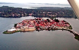
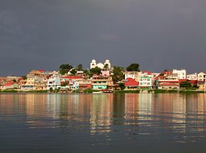
The old part of the city is located on an island
on Lake Peten Itza
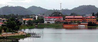
, connected to the mainland by a short causeway. On the mainland are the suburb towns of Santa Elena and San Benito.
In Pre-Columbian
times, Flores was the Maya
city of Tayasal
.
 Flores is served by the Santa Elena International Airport but commonly known as Mundo Maya International Airport
. Several International flights are served but mainly all of them stop first on Guatemala City
's La Aurora International Airport
.
left the Yucatán
region in the 13th century and built the city later known as Tayasal as their capital. They called it Noh (Nohoch) Petén, literally "City Island". It was also called Tah Itzá, or Place of the Itzá.
 It was here, on the island of Flores on the shore of Lake Petén Itzá, that the last independent Maya state held out against the Spanish conquerors. In 1541, Hernán Cortés
came to the island, on route to Honduras
, but needed to move on and did not try to conquer it.
The Spanish did not manage to conquer the island until 1697, when they marched in, attacked via boats, and destroyed it. Those who could flee did so, and many Itzá people hid in the jungle for years. From the ruins of Noh Petén arose the modern city of Flores.

Petén (department)
Petén is a department of the nation of Guatemala. It is geographically the northernmost department of Guatemala, as well as the largest in size — at it accounts for about one third of Guatemala's area. The capital is Flores...
department
Departments of Guatemala
||Guatemala is divided into 22 departments :#Alta Verapaz#Baja Verapaz#Chimaltenango#Chiquimula#Petén#El Progreso#El Quiché#Escuintla#Guatemala#Huehuetenango#Izabal#Jalapa#Jutiapa#Quetzaltenango#Retalhuleu#Sacatepéquez...
of Guatemala
Guatemala
Guatemala is a country in Central America bordered by Mexico to the north and west, the Pacific Ocean to the southwest, Belize to the northeast, the Caribbean to the east, and Honduras and El Salvador to the southeast...
. It is located at 16°54′N 89°54′W. The population is 13,700 (2003).
Flores serves as the municipal seat for the surrounding municipality, with which it shares a name (population 22,600).
The old part of the city is located on an island
Island
An island or isle is any piece of sub-continental land that is surrounded by water. Very small islands such as emergent land features on atolls can be called islets, cays or keys. An island in a river or lake may be called an eyot , or holm...
on Lake Peten Itza
Lake Petén Itzá
Lake Petén Itzá is a lake in the northern department Petén in Guatemala. It is the second largest lake in Guatemala, the Izabal lake being the largest. It is located around . It has an area of 99 km² some 32 km. long and 5 km wide. Its maximum depth is 160 m...
, connected to the mainland by a short causeway. On the mainland are the suburb towns of Santa Elena and San Benito.
In Pre-Columbian
Pre-Columbian
The pre-Columbian era incorporates all period subdivisions in the history and prehistory of the Americas before the appearance of significant European influences on the American continents, spanning the time of the original settlement in the Upper Paleolithic period to European colonization during...
times, Flores was the Maya
Maya civilization
The Maya is a Mesoamerican civilization, noted for the only known fully developed written language of the pre-Columbian Americas, as well as for its art, architecture, and mathematical and astronomical systems. Initially established during the Pre-Classic period The Maya is a Mesoamerican...
city of Tayasal
Tayasal
Tayasal is a pre-Columbian Maya archaeological site that dates to the Postclassic period. The site is located in the southern Maya lowlands on a small island in Lake Petén Itzá, now part of the Department of Petén in northern Guatemala...
.
Transportation
Mundo Maya International Airport
Mundo Maya International Airport , also known as Flores International Airport, is an international airport located in the suburb of Santa Elena, in the city of Flores, Guatemala...
. Several International flights are served but mainly all of them stop first on Guatemala City
Guatemala City
Guatemala City , is the capital and largest city of the Republic of Guatemala and Central America...
's La Aurora International Airport
La Aurora International Airport
La Aurora International Airport serves Guatemala City, Guatemala. It is located south of Guatemala City's center and from Antigua. It is administered by the Dirección General de Aeronáutica Civil....
.
Tayasal
The ItzaItza
The Itza are a Guatemalan ethnic group of Maya affiliation speaking the Itza' language. They inhabit the Petén department of Guatemala in and around the city of Flores on the Lake Petén Itzá.- Numbers of ethnic group members and Itza speakers :...
left the Yucatán
Yucatán
Yucatán officially Estado Libre y Soberano de Yucatán is one of the 31 states which, with the Federal District, comprise the 32 Federal Entities of Mexico. It is divided in 106 municipalities and its capital city is Mérida....
region in the 13th century and built the city later known as Tayasal as their capital. They called it Noh (Nohoch) Petén, literally "City Island". It was also called Tah Itzá, or Place of the Itzá.
Hernán Cortés
Hernán Cortés de Monroy y Pizarro, 1st Marquis of the Valley of Oaxaca was a Spanish Conquistador who led an expedition that caused the fall of the Aztec Empire and brought large portions of mainland Mexico under the rule of the King of Castile in the early 16th century...
came to the island, on route to Honduras
Honduras
Honduras is a republic in Central America. It was previously known as Spanish Honduras to differentiate it from British Honduras, which became the modern-day state of Belize...
, but needed to move on and did not try to conquer it.
The Spanish did not manage to conquer the island until 1697, when they marched in, attacked via boats, and destroyed it. Those who could flee did so, and many Itzá people hid in the jungle for years. From the ruins of Noh Petén arose the modern city of Flores.
See also
- Spanish conquest of YucatánSpanish conquest of YucatánThe Spanish conquest of Yucatán was the campaign undertaken by the Spanish conquistadores against the Late Postclassic Maya states and polities, particularly in the northern and central Yucatán Peninsula but also involving the Maya polities of the Guatemalan highlands region...
External links
- Travel guide to Flores on WikitravelWikitravel-External links:* *...
- Photos of Flores, Guatemala