

Hollyford Track
Encyclopedia
New Zealand
New Zealand is an island country in the south-western Pacific Ocean comprising two main landmasses and numerous smaller islands. The country is situated some east of Australia across the Tasman Sea, and roughly south of the Pacific island nations of New Caledonia, Fiji, and Tonga...
. Located at the northern edge of Fiordland
Fiordland
Fiordland is a geographic region of New Zealand that is situated on the south-western corner of the South Island, comprising the western-most third of Southland. Most of Fiordland is dominated by the steep sides of the snow-capped Southern Alps, deep lakes and its ocean-flooded, steep western valleys...
, in the southwestern South Island
South Island
The South Island is the larger of the two major islands of New Zealand, the other being the more populous North Island. It is bordered to the north by Cook Strait, to the west by the Tasman Sea, to the south and east by the Pacific Ocean...
, it is unusual among Fiordland's major tracks in that it is largely flat and accessible year-round. It follows the Hollyford River
Hollyford River
The Hollyford River is located in the southwest of the South Island of New Zealand. It runs for eighty miles in Fiordland, its source being ten kilometres to the north of the northern tip of Lake Te Anau and close to the Homer Tunnel....
which in turn follows the course of the Hollyford Valley
Hollyford Valley
Hollyford Valley is a valley in Fiordland, New Zealand, in the southwest of the South Island. It is named for the Hollyford River, which runs north-north-west along its length from the Southern Alps to the Tasman Sea...
.
History
The Māori people were the first to settle the area around Martins Bay, though by the time of the arrival of Europeans in the mid-19th century, only a handful remained in the area. One of these was Tutoko, for whom Mount TutokoMount Tutoko
Mount Tutoko is the highest peak in Fiordland National Park, in southwest New Zealand. It lies between the Hollyford Valley and Milford Sound, 15 kilometres due north of the Homer Tunnel, and rises to a height of 2756 m...
, which rises 2700m above the Hollyford valley, was subsequently named.
The first Europeans to reach the bay via an inland route was Patrick Caples in 1863, although early runholders David McKellar and George Gunn had mapped some of the valley two years previously. Also in 1863, a small ship captained by a Captain Alabaster crossed the sandbar at Martins Bay to reach Lake McKerrow.
In the early days of European settlement, there was much enthusiasm for a commercial port at Martins Bay, led by the Otago Provincial Council. A settlement - Jamestown - was surveyed and several houses built, but the lack of road links to the rest of the province and the dangerous sandbar led to the gradual waning of the settlement, which was practically deserted by 1879, only some eleven years after its founding. Only one family, the McKenzies, remained close to Martins Bay. They sold their property to Davy Gunn in 1926. Gunn continued to farm the area, and also mapped the area and was a pioneer in the tramping tourism industry, taking parties of walkers along the valleys of the Hollyford, Pyke and Cascade Rivers. After his death in 1955, his son Murray continued to guide trampers in the area, and started "Gunn's Camp", a rest-stop for trampers with store and small museum, which still stands near the southern end of the track, around 10km from the Milford Sound
Milford Sound
Milford Sound is a fjord in the south west of New Zealand's South Island, within Fiordland National Park, Piopiotahi Marine Reserve, and the Te Wahipounamu World Heritage site...
-Te Anau
Te Anau
Te Anau is a town in the South Island of New Zealand. It is on the eastern shore of Lake Te Anau in Fiordland. Lake Te Anau is the largest lake in the South Island and second only within New Zealand to Lake Taupo. The 2001 census recorded the town's population as 1,857...
highway.
The gravel road was being constructed up until 1941 when the workers were taken off the job for the war effort and was worked on both ends. After World War II the idea of a road linking Haast to Hollyford was reignited to allow access and used prison and unemployed labor to progress the work. In 1960, the valley became part of Fiordland National Park
Fiordland National Park
Fiordland National Park occupies the southwest corner of the South Island of New Zealand. It is the largest of the 14 national parks in New Zealand, with an area of 12,500 km², and a major part of the Te Wahipounamu World Heritage site...
and Davy Gunn's original tracks have since been upgraded and tramping huts established.
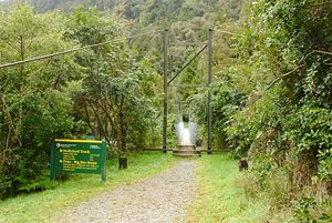
The track
The track is 56 kilometres in length. It runs in a roughly south-north direction, its southern end being accessible by road 15 kilometres to the east of the Homer TunnelHomer Tunnel
The Homer Tunnel is a road tunnel in the Fiordland region of the South Island of New Zealand, opened in 1954. New Zealand State Highway 94 passes through the tunnel, linking Milford Sound to Te Anau and Queenstown, by piercing the Main Divide at the Homer Saddle...
, and its northern end being at the Tasman Sea
Tasman Sea
The Tasman Sea is the large body of water between Australia and New Zealand, approximately across. It extends 2,800 km from north to south. It is a south-western segment of the South Pacific Ocean. The sea was named after the Dutch explorer Abel Janszoon Tasman, the first recorded European...
coast at Martins Bay, north of Milford Sound
Milford Sound
Milford Sound is a fjord in the south west of New Zealand's South Island, within Fiordland National Park, Piopiotahi Marine Reserve, and the Te Wahipounamu World Heritage site...
.
For most of its path, the track follows the course of the Hollyford River
Hollyford River
The Hollyford River is located in the southwest of the South Island of New Zealand. It runs for eighty miles in Fiordland, its source being ten kilometres to the north of the northern tip of Lake Te Anau and close to the Homer Tunnel....
/ Hollyford Valley
Hollyford Valley
Hollyford Valley is a valley in Fiordland, New Zealand, in the southwest of the South Island. It is named for the Hollyford River, which runs north-north-west along its length from the Southern Alps to the Tasman Sea...
. Features of the track are the two lakes, Lake Alabaster
Lake Alabaster
Lake Alabaster, also known by the Maori name of Waiwahuika, lies at the northern end of Fiordland, in the southwest of New Zealand's South Island. The lake runs from northeast to southwest, is six kilometres in length, and covers 7 km²....
(or Waiwahuika) and Lake McKerrow
Lake McKerrow
Lake McKerrow, also known by the Maori name of Whakatipu Waitai, lies at the northern end of Fiordland, in the southwest of New Zealand's South Island. The lake runs from southeast to northwest, is 15 kilometres in length, and covers 28 km²....
(or Whakatipu Waitai), the latter being a fiord now cut off from the sea by sediment. The track runs through lowland forest, with views of surrounding mountains. Wildlife visible from the track include seals
Pinniped
Pinnipeds or fin-footed mammals are a widely distributed and diverse group of semiaquatic marine mammals comprising the families Odobenidae , Otariidae , and Phocidae .-Overview: Pinnipeds are typically sleek-bodied and barrel-shaped...
, penguin
Penguin
Penguins are a group of aquatic, flightless birds living almost exclusively in the southern hemisphere, especially in Antarctica. Highly adapted for life in the water, penguins have countershaded dark and white plumage, and their wings have become flippers...
s, and heron
Heron
The herons are long-legged freshwater and coastal birds in the family Ardeidae. There are 64 recognised species in this family. Some are called "egrets" or "bitterns" instead of "heron"....
s.
Road proposals
There have been a number of proposals for a road in the vicinity of the track to link HaastHaast, New Zealand
Haast is an area in the Westland District territorial authority on the west coast of New Zealand's South Island. The Haast region covers over ....
with the Milford Sound
Milford Sound
Milford Sound is a fjord in the south west of New Zealand's South Island, within Fiordland National Park, Piopiotahi Marine Reserve, and the Te Wahipounamu World Heritage site...
road, proposed as early as the 1870s.
In 2001 a widely distributed newspaper advertising supplement "The South Island Loop" promoted the Hollyford road as well as a road in the vicinity of the Heaphy Track
Heaphy Track
The Heaphy Track is a popular tramping track in the north west of the South Island of New Zealand. It is located within the Kahurangi National Park and classified as one of New Zealand's nine Great Walks by the Department of Conservation. Named after Charles Heaphy, the track is 82 km long and...
. Mayors in the South Island and other supporters pushed for having the road built. Forest and Bird, New Zealand's largest conservation organisation, called it the "biological equivalent of smashing the Mona Lisa". In January 2010, the National-led government
Fifth National Government of New Zealand
The Fifth National Government of New Zealand is the current government of New Zealand. It is led by Prime Minister John Key.After the 2008 general election the National Party and its allies were able to form a government, taking over from Helen Clark's Fifth Labour Government. The National party...
confirmed that it was considering a Hollyford road proposal. The Westland District
Westland District
Westland District is a territorial authority on the west coast of New Zealand's South Island. Its population is - Government :The Westland District is governed by an elected Council, headed by an elected Mayor. The Mayor is elected at large. The current Mayor is Maureen Pugh. Councillors are...
Council and the owner of a hotel chain are backing plans for the road. The plans were however put on hold in March 2010, when government decided that the investment was a low priority.
Further reading
- Temple, P. (1984). The Shell guide to the Hollyford Track (3rd ed.). Christchurch: Whitcoulls. ISBN 0-7233-0713-X
External links
- Hollyford Track at the Department of Conservation