
Highways in Nunavut
Encyclopedia
Currently, an estimated total of 850 km (530 mi) of roads and highways are spread across Nunavut
. Over the next decade the amount of roads in the territory is expected to increase rapidly as more communities are linked together, and a road link to Manitoba
is at planning stage.
Most vehicles in the territory are moved from community to community and in and out of the territory by large barges that move during the summer shipping season. Less commonly, vehicles may be flown in on a cargo plane. Car companies will usually fly vehicles in to test them in Arctic conditions.
There is currently one winter road
that provides access to the western portion of Nunavut from the Northwest Territories
during the months of February to March.
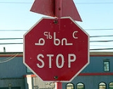
 Highways in Nunavut, the few that exist, are not yet numbered. Street signs are in English, Inuktitut
and Inuinnaqtun
.
Compared to the rest of Canada, maintaining a vehicle in Nunavut is expensive. Rough roads and harsh weather result in expensive upkeep for vehicles, and despite being subsidised by the government, gas prices are among the highest in Canada. Parts can take an extremely long time to ship in and are very expensive. Mechanics also charge a premium, since very few do business in the territory. Due to the lack to a cohesive road network, aircraft are still the preferred way to travel, along with ATVs
through most of the year, snowmobile
s in winter, and boats during the summer months. Travel by dog sled
has largely disappeared, although recreational dog-sledding is still common.
About 4000 vehicles are registered in the territory. Many makes and models of vehicles can be found in the territory, but the most common are heavy-duty four-wheel-drive vehicles such as sport utility, jeeps and full-size vans. A wide range of vehicles can be found in Iqaluit, where the government tends to do most of its business and the road system consists of paved and chip-sealed portions, although it too is primarily dirt.
Despite Nunavut's isolation from the rest of Canada's road network, provincial license plates can be found from Newfoundland and Labrador, Quebec, and Northwest Territories, as well as government plates from the Department of National Defense
; vehicles of all provincial plates can sometimes be found in the territory. Nunavut, like the Northwest Territories, is one of the few jurisdictions in the world where non-rectangular licence plates can be found; which soon may change as the Nunavut government is considering a license plate design change to avoid confusion with that of the Northwest Territories once more road connections and highways are built.
Vehicles can display their old provincial plates for ninety days before they must be registered in the territory.
The only road that links communities is the unnamed, unnumbered road (see below) between Arctic Bay
and Nanisivik
, although Nanisivik was closed in 2005, and being contaminated with lead, is unlikely to be occupied in future. This road is used to access Nanisivik Airport
and for an annual marathon.
An ice road, almost entirely within the Northwest Territories, from Yellowknife, Northwest Territories
to Contwoyto Lake
(see below), open for just one month per year, is the only surface vehicle access from the North American highway network that reaches across the Nunavut border, but there are no settlements at the end, only diamond mining operations and worker lodgings. The road is a dangerous one for truckers, who risk breaking through the ice.
A road was briefly considered in 2004 for construction between Iqaluit and Kimmirut
(formerly known as Lake Harbour), but it would be four times longer than the direct air-distance between the communities, and the idea was dropped.
A proposal is in place for a billion-dollar highway to Rankin Inlet, Nunavut
from Gillam
, Manitoba
with a connection to Churchill, Manitoba
, a route that was chosen over two other alternatives from Thompson
and Lynn Lake
. This highway along the west shore of Hudson Bay
would be the first true highway into Nunavut from the provinces.
The winter road services a number of mines in the Western edge of Nunavut as well as mines in the Northwest Territories.
A 210 km (130 mi) all weather extension is planned from Contwoyto Lake to the tiny town of Bathurst Inlet
where a port will be built to provide shipping to nearby communities.
The entire road is 568 km (353 mi) and is the world's longest heavy haul ice road
. It is open between February and March each year.
to the former mining town of Nanisivik
. The road also gained world fame for a number of years when it was used for the Midnight Sun Marathon
run but has become less important when the mine shut down in 2002. However, it should benefit from the Canadian Forces planned $100 million expansion of the Nanisivik deep water port and airport announced on August 10, 2007, by Prime Minister Stephen Harper.
Weather Station to CFB Eureka and the Eureka Airport.
This road is also notable as the last known road in Canada with a road sign
in imperial measurement.
in order to keep their soldiers busy while they waited for the sea-ice to open up to let them go home in the summer of 1956.
The bridge across Kujesse (Apex Creek) was a gift from the Government of Ontario's
Department of Highways the following year.
The inaugural trip down Apex Hill led to a truckload of soldiers in the ditch. The brakes on the army vehicle had not been tested for several years in the "flats" of what was then Frobisher Bay, and they did not hold when tested on the new road. Only pride was injured when the truck hit the ditch on its first trip.
Prior to the road being built, schoolchildren living near the base at "Ikaluit" walked to Federal Day School in Apex over the sea ice
or stayed with relatives in Apex, as the base in Frobisher Bay was "off limits" to Inuit
.
Today, this road has been developed along much of its 5 km (3 mi) length. It is now one of the busiest roads in the territory, a typical rush hour sustains 500 cars an hour, although rush hour itself is locally called the "rush minute".
(Mount Pelly). Another road runs west approximately 14 km (9 mi) from the hamlet.
on Southampton Island
with its airport, 11 km (7 mi) away.
Image Links
Nunavut
Nunavut is the largest and newest federal territory of Canada; it was separated officially from the Northwest Territories on April 1, 1999, via the Nunavut Act and the Nunavut Land Claims Agreement Act, though the actual boundaries had been established in 1993...
. Over the next decade the amount of roads in the territory is expected to increase rapidly as more communities are linked together, and a road link to Manitoba
Manitoba
Manitoba is a Canadian prairie province with an area of . The province has over 110,000 lakes and has a largely continental climate because of its flat topography. Agriculture, mostly concentrated in the fertile southern and western parts of the province, is vital to the province's economy; other...
is at planning stage.
Most vehicles in the territory are moved from community to community and in and out of the territory by large barges that move during the summer shipping season. Less commonly, vehicles may be flown in on a cargo plane. Car companies will usually fly vehicles in to test them in Arctic conditions.
There is currently one winter road
Winter road
Winter roads are temporary highways carved out of snow and ice. They facilitate transportation to and from communities without permanent roads, and are commonly seen in isolated regions in Canada's north....
that provides access to the western portion of Nunavut from the Northwest Territories
Northwest Territories
The Northwest Territories is a federal territory of Canada.Located in northern Canada, the territory borders Canada's two other territories, Yukon to the west and Nunavut to the east, and three provinces: British Columbia to the southwest, and Alberta and Saskatchewan to the south...
during the months of February to March.
Inuktitut
Inuktitut or Eastern Canadian Inuktitut, Eastern Canadian Inuit language is the name of some of the Inuit languages spoken in Canada...
and Inuinnaqtun
Inuinnaqtun
Inuinnaqtun , is an indigenous Inuit language of Canada and a dialect of Inuvialuktun. It is related very closely to Inuktitut, and some scholars, such as Richard Condon, believe that Inuinnaqtun is more appropriately classified as a dialect of Inuktitut...
.
Compared to the rest of Canada, maintaining a vehicle in Nunavut is expensive. Rough roads and harsh weather result in expensive upkeep for vehicles, and despite being subsidised by the government, gas prices are among the highest in Canada. Parts can take an extremely long time to ship in and are very expensive. Mechanics also charge a premium, since very few do business in the territory. Due to the lack to a cohesive road network, aircraft are still the preferred way to travel, along with ATVs
All-terrain vehicle
An all-terrain vehicle , also known as a quad, quad bike, three wheeler, or four wheeler, is defined by the American National Standards Institute as a vehicle that travels on low pressure tires, with a seat that is straddled by the operator, along with handlebars for steering control...
through most of the year, snowmobile
Snowmobile
A snowmobile, also known in some places as a snowmachine, or sled,is a land vehicle for winter travel on snow. Designed to be operated on snow and ice, they require no road or trail. Design variations enable some machines to operate in deep snow or forests; most are used on open terrain, including...
s in winter, and boats during the summer months. Travel by dog sled
Dog sled
A dog sled is a sled pulled by one or more sled dogs used to travel over ice and through snow. Numerous types of sleds are used, depending on their function. They can be used for dog sled racing.-History:...
has largely disappeared, although recreational dog-sledding is still common.
About 4000 vehicles are registered in the territory. Many makes and models of vehicles can be found in the territory, but the most common are heavy-duty four-wheel-drive vehicles such as sport utility, jeeps and full-size vans. A wide range of vehicles can be found in Iqaluit, where the government tends to do most of its business and the road system consists of paved and chip-sealed portions, although it too is primarily dirt.
Despite Nunavut's isolation from the rest of Canada's road network, provincial license plates can be found from Newfoundland and Labrador, Quebec, and Northwest Territories, as well as government plates from the Department of National Defense
Department of National Defence (Canada)
The Department of National Defence , frequently referred to by its acronym DND, is the department within the government of Canada with responsibility for all matters concerning the defence of Canada...
; vehicles of all provincial plates can sometimes be found in the territory. Nunavut, like the Northwest Territories, is one of the few jurisdictions in the world where non-rectangular licence plates can be found; which soon may change as the Nunavut government is considering a license plate design change to avoid confusion with that of the Northwest Territories once more road connections and highways are built.
Vehicles can display their old provincial plates for ninety days before they must be registered in the territory.
The only road that links communities is the unnamed, unnumbered road (see below) between Arctic Bay
Arctic Bay, Nunavut
Arctic Bay is an Inuit hamlet located in the northern part of the Borden Peninsula on Baffin Island in the Qikiqtaaluk Region of Nunavut, Canada. Arctic Bay is located in the Eastern Time Zone although it is quite close to the time zone boundary. The predominant languages are Inuktitut and English...
and Nanisivik
Nanisivik, Nunavut
Nanisivik was a company town which was built in 1975 to support the lead-zinc mining and mineral processing operations for the Nanisivik Mine, in production between 1976 and 2002...
, although Nanisivik was closed in 2005, and being contaminated with lead, is unlikely to be occupied in future. This road is used to access Nanisivik Airport
Nanisivik Airport
Nanisivik Airport was located south of Nanisivik, Nunavut, Canada, and was operated by the Government of Nunavut. Although Nanisivik Mine closed in September 2002 the airport was in operation until 2011 and served the community of Arctic Bay. This was due to the small size of Arctic Bay Airport...
and for an annual marathon.
An ice road, almost entirely within the Northwest Territories, from Yellowknife, Northwest Territories
Yellowknife, Northwest Territories
Yellowknife is the capital and largest city of the Northwest Territories , Canada. It is located on the northern shore of Great Slave Lake, approximately south of the Arctic Circle, on the west side of Yellowknife Bay near the outlet of the Yellowknife River...
to Contwoyto Lake
Contwoyto Lake
Contwoyto Lake is a lake in the Kitikmeot Region of the Canadian territory of Nunavut, located near the border with the Northwest Territories. With a total area of , it is the territories' tenth largest lake.Lupin Mine is located near Contwoyto Lake...
(see below), open for just one month per year, is the only surface vehicle access from the North American highway network that reaches across the Nunavut border, but there are no settlements at the end, only diamond mining operations and worker lodgings. The road is a dangerous one for truckers, who risk breaking through the ice.
A road was briefly considered in 2004 for construction between Iqaluit and Kimmirut
Kimmirut, Nunavut
Kimmirut is a community in the Qikiqtaaluk Region, Nunavut, Canada. It is located on the shore of Hudson Strait on Baffin Island's Meta Incognita Peninsula. Kimmirut means "heel", and refers to a rocky outcrop in the inlet.It was at one time a Hudson's Bay Company trading post, and a Royal...
(formerly known as Lake Harbour), but it would be four times longer than the direct air-distance between the communities, and the idea was dropped.
A proposal is in place for a billion-dollar highway to Rankin Inlet, Nunavut
Nunavut
Nunavut is the largest and newest federal territory of Canada; it was separated officially from the Northwest Territories on April 1, 1999, via the Nunavut Act and the Nunavut Land Claims Agreement Act, though the actual boundaries had been established in 1993...
from Gillam
Gillam, Manitoba
Gillam, Manitoba, Canada, is a community between Thompson and Churchill on the Hudson Bay Railway line. Gillam is a significant community because of the nearby Nelson River Bipole converter station on the Nelson River...
, Manitoba
Manitoba
Manitoba is a Canadian prairie province with an area of . The province has over 110,000 lakes and has a largely continental climate because of its flat topography. Agriculture, mostly concentrated in the fertile southern and western parts of the province, is vital to the province's economy; other...
with a connection to Churchill, Manitoba
Churchill, Manitoba
Churchill is a town on the shore of Hudson Bay in Manitoba, Canada. It is most famous for the many polar bears that move toward the shore from inland in the autumn, leading to the nickname "Polar Bear Capital of the World" that has helped its growing tourism industry.-History:A variety of nomadic...
, a route that was chosen over two other alternatives from Thompson
Thompson, Manitoba
Thompson is a city in northern Manitoba. As the "Hub of the North" it serves as the regional trade and service centre of northern Manitoba. Thompson is located north of the Canada – United States border, north of the provincial capital of Winnipeg, and is northeast of Flin Flon...
and Lynn Lake
Lynn Lake, Manitoba
Lynn Lake is a small town in the northwest region of Manitoba, Canada, 1,071 km from Winnipeg. The town was named after Lynn Smith, chief engineer of Sherritt Gordon Mines Ltd. There are numerous outfitters in the Lynn Lake area...
. This highway along the west shore of Hudson Bay
Hudson Bay
Hudson Bay , sometimes called Hudson's Bay, is a large body of saltwater in northeastern Canada. It drains a very large area, about , that includes parts of Ontario, Quebec, Saskatchewan, Alberta, most of Manitoba, southeastern Nunavut, as well as parts of North Dakota, South Dakota, Minnesota,...
would be the first true highway into Nunavut from the provinces.
Tibbitt to Contwoyto Winter Road
This is currently the only way to drive to Nunavut from the South.The winter road services a number of mines in the Western edge of Nunavut as well as mines in the Northwest Territories.
A 210 km (130 mi) all weather extension is planned from Contwoyto Lake to the tiny town of Bathurst Inlet
Bathurst Inlet, Nunavut
Bathhurst Inlet, , is a small Inuit community located in Bathurst Inlet in the Kitikmeot Region of Canada's Nunavut Territory...
where a port will be built to provide shipping to nearby communities.
The entire road is 568 km (353 mi) and is the world's longest heavy haul ice road
Ice road
Ice roads are frozen, human-made structures on the surface of bays, rivers, lakes, or seas in the far north. They link dry land, frozen waterways, portages and winter roads, and are usually remade each winter. Ice roads allow temporary transport to areas with no permanent road access...
. It is open between February and March each year.
Arctic Bay to Nanisivik Highway
This 21 km (13 mi) stretch of Highway connects the town of Arctic BayArctic Bay, Nunavut
Arctic Bay is an Inuit hamlet located in the northern part of the Borden Peninsula on Baffin Island in the Qikiqtaaluk Region of Nunavut, Canada. Arctic Bay is located in the Eastern Time Zone although it is quite close to the time zone boundary. The predominant languages are Inuktitut and English...
to the former mining town of Nanisivik
Nanisivik, Nunavut
Nanisivik was a company town which was built in 1975 to support the lead-zinc mining and mineral processing operations for the Nanisivik Mine, in production between 1976 and 2002...
. The road also gained world fame for a number of years when it was used for the Midnight Sun Marathon
Nunavut Midnight Sun Marathon
The Nunavut Midnight Sun Marathon is an annual ultramarathon race that takes place in Arctic Bay, Nunavut, Canada....
run but has become less important when the mine shut down in 2002. However, it should benefit from the Canadian Forces planned $100 million expansion of the Nanisivik deep water port and airport announced on August 10, 2007, by Prime Minister Stephen Harper.
Eureka Highway
This is a 20 km (12 mi) all weather highway that provides the link from EurekaWeather Station to CFB Eureka and the Eureka Airport.
This road is also notable as the last known road in Canada with a road sign
in imperial measurement.
Federal Road, Iqaluit
The main road in Iqaluit, this road provides access from the Airport to the City Centre as well as the Nunavut Legislature Building.Road to Apex, Iqaluit
This road provides access from Iqaluit to the original community of Apex (Niaqunguut). The road was built by the United States Army Corps of EngineersUnited States Army Corps of Engineers
The United States Army Corps of Engineers is a federal agency and a major Army command made up of some 38,000 civilian and military personnel, making it the world's largest public engineering, design and construction management agency...
in order to keep their soldiers busy while they waited for the sea-ice to open up to let them go home in the summer of 1956.
The bridge across Kujesse (Apex Creek) was a gift from the Government of Ontario's
Politics of Ontario
The Province of Ontario is governed by a unicameral legislature, the Legislative Assembly of Ontario, which operates in the Westminster system of government...
Department of Highways the following year.
The inaugural trip down Apex Hill led to a truckload of soldiers in the ditch. The brakes on the army vehicle had not been tested for several years in the "flats" of what was then Frobisher Bay, and they did not hold when tested on the new road. Only pride was injured when the truck hit the ditch on its first trip.
Prior to the road being built, schoolchildren living near the base at "Ikaluit" walked to Federal Day School in Apex over the sea ice
Sea ice
Sea ice is largely formed from seawater that freezes. Because the oceans consist of saltwater, this occurs below the freezing point of pure water, at about -1.8 °C ....
or stayed with relatives in Apex, as the base in Frobisher Bay was "off limits" to Inuit
Inuit
The Inuit are a group of culturally similar indigenous peoples inhabiting the Arctic regions of Canada , Denmark , Russia and the United States . Inuit means “the people” in the Inuktitut language...
.
Today, this road has been developed along much of its 5 km (3 mi) length. It is now one of the busiest roads in the territory, a typical rush hour sustains 500 cars an hour, although rush hour itself is locally called the "rush minute".
Alert to Alert Airport Road
This roughly 6 km (4 mi) stretch of all weather road is the most northern stretch of road in the world. This road provides access from CFB Alert to the Alert Airport.Ovayok Road
Runs from Cambridge Bay eastward 17 km (11 mi) to Ovayok Territorial ParkOvayok Territorial Park, Nunavut
Ovayok Territorial Park is a park situated east of Cambridge Bay, Kitikmeot, Nunavut, Canada. The park is relatively small and covers an area of approximately...
(Mount Pelly). Another road runs west approximately 14 km (9 mi) from the hamlet.
Coral Harbour Airport Road
Connects the hamlet of Coral HarbourCoral Harbour, Nunavut
Coral Harbour , is a small Inuit community that is located on Southampton Island, Kivalliq Region, in the Canadian territory of Nunavut. Its name is derived from the fossilized coral that can be found around the waters of the community which is situated at the head of South Bay...
on Southampton Island
Southampton Island
Southampton Island is a large island at the entrance to Hudson Bay at Foxe Basin. One of the larger members of the Canadian Arctic Archipelago, Southampton Island is part of the Kivalliq Region in Nunavut, Canada. The area of the island is stated as by Statistics Canada . It is the 34th largest...
with its airport, 11 km (7 mi) away.
External links
- Study for proposed Manitoba-Nunavut road
- News article on the proposal for the Manitoba-Nunavut road.
- Contwoyto Winter Road Facts
- News Article on Nunavut Traffic Safety
- News article on Newfoundland plates, traffic congestion and traffic statistics in Nunavut
- Road to Nowhere rezoning report at Nunastsiaq News
Image Links