
.gif)
Highway 66 (Ontario)
Encyclopedia
King's Highway 66, commonly referred to as Highway 66, is a provincially maintained highway in the Canadian
province of Ontario
.Located in the Timiskaming District
, the highway begins at Matachewan
near a junction with Highway 65. It extends eastward for 107 kilometres (66.5 mi) to the Quebec
border just east of Kearns. At the provincial border, the highway continues eastward as Route 117
. From Highway 11 (41 kilometres (25.5 mi) east of Matachewan) at Kenogami Lake
eastwards to the Quebec border, Highway 66 is designated as part of the Trans-Canada Highway
.
 Beginning at the village of Matachewan, where the highway continues west as Highway 566, the route travels 4.6 kilometres (2.9 mi) east to a junction with Highway 65. From there to the community of Kenogami Lake, on Highway 11, the highway passes through a 40 kilometres (24.9 mi) wilderness, encountering few roads or signs of humanity. Instead the highway winds through rock cuts, muskeg
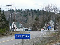
and thick coniferous forests. After intersecting Highway 11, the route continues east through the community of Swastika
. It encounters Highway 112 between Swastika and the community of Chaput Hughes, after which the highway enters the town of Kirkland Lake. East of the town, Highway 66 passes through King Kirkland
and encounters Highway 672
. East of here, the highway returns to a remote setting, passing through the community of Larder Lake
, where it encounters Highway 624. For the remaining 17 kilometres (10.6 mi), the route snakes through the wilderness, passing through the communities of Virginiatown and Kearns between long segments of forest. Immediately east of Kearns, the highway crosses the Ontario–Quebec border, where it continues as Quebec Route 117
to Rouyn-Noranda.
The entirety of Highway 66 is located within Timiskaming District in the rugged and remote Canadian Shield
. Outside of the communities along the route, there is almost no inhabitation or services. Consequently, traffic volumes drop considerably east of Highway 11.
shortly after its merger with the Department of Northern Development (DND).
The DND created the road during the early 1930s, connecting several rail stops. The Kirkland Lake area is the site of several gold deposits that were discovered during the first quarter of the century, and the King's Highway status brought about new improvements to help service the mines. Initially, the route was only 26.2 miles (42.2 km) long, connecting Kirkland Lake with the Ontario–Quebec border. On November 16, 1955, the route was extended 25.5 miles (41 km) east to Highway 65 near Matachewan.
Although several minor realignments to improve the rugged route have been made since then, it did not change significantly between 1956 and 1997. On April 1, 1997, a 1.9 kilometres (1.2 mi) section of the highway, between Goldthorpe Drive and Main Street, was transferred to the city of Kirkland Lake.
Canada
Canada is a North American country consisting of ten provinces and three territories. Located in the northern part of the continent, it extends from the Atlantic Ocean in the east to the Pacific Ocean in the west, and northward into the Arctic Ocean...
province of Ontario
Ontario
Ontario is a province of Canada, located in east-central Canada. It is Canada's most populous province and second largest in total area. It is home to the nation's most populous city, Toronto, and the nation's capital, Ottawa....
.Located in the Timiskaming District
Timiskaming District, Ontario
Timiskaming is a district and census division in Northeastern Ontario in the Canadian province of Ontario. The district was created in 1912 from parts of Algoma, Nipissing, and Sudbury districts. In 1921, Cochrane District was created from parts of this district and parts of Thunder Bay...
, the highway begins at Matachewan
Matachewan, Ontario
Matachewan is a small township in Timiskaming, northeastern Ontario, Canada, located at the end of Ontario Highway 66 along the Montreal River.The town's main economy is based on mineral mining, mainly gold mining, with some tourism.-History:...
near a junction with Highway 65. It extends eastward for 107 kilometres (66.5 mi) to the Quebec
Quebec
Quebec or is a province in east-central Canada. It is the only Canadian province with a predominantly French-speaking population and the only one whose sole official language is French at the provincial level....
border just east of Kearns. At the provincial border, the highway continues eastward as Route 117
Quebec route 117
Route 117 is a provincial highway within the Canadian province of Quebec, running between Montreal and the Quebec/Ontario border where it continues as Highway 66 east of Kearns, Ontario...
. From Highway 11 (41 kilometres (25.5 mi) east of Matachewan) at Kenogami Lake
Kenogami Lake, Ontario
Kenogami Lake is an unincorporated place and community in the Unorganized West Part of Timiskaming District in northwestern Ontario, Canada. It is located on Kenogami Lake on the Blanche River in the Saint Lawrence River drainage basin.-Transportation:...
eastwards to the Quebec border, Highway 66 is designated as part of the Trans-Canada Highway
Trans-Canada Highway
The Trans-Canada Highway is a federal-provincial highway system that joins the ten provinces of Canada. It is, along with the Trans-Siberian Highway and Australia's Highway 1, one of the world's longest national highways, with the main route spanning 8,030 km...
.
Route description
Muskeg
Muskeg is an acidic soil type common in Arctic and boreal areas, although it is found in other northern climates as well. Muskeg is approximately synonymous with bogland but muskeg is the standard term in Western Canada and Alaska, while 'bog' is common elsewhere. The term is of Cree origin, maskek...
and thick coniferous forests. After intersecting Highway 11, the route continues east through the community of Swastika
Swastika, Ontario
Swastika is a small community founded in 1908 around a mining site in Northern Ontario, Canada, and today within the municipal boundaries of Kirkland Lake, Ontario....
. It encounters Highway 112 between Swastika and the community of Chaput Hughes, after which the highway enters the town of Kirkland Lake. East of the town, Highway 66 passes through King Kirkland
King-Lebel, Ontario
King-Lebel is a designated place in the Canadian province of Ontario, located in the Timiskaming District. The community, located between the town of Kirkland Lake and the municipal township of Gauthier, consists of the unincorporated township of Lebel, whose primary settlement is the community of...
and encounters Highway 672
Ontario Highway 672
Highway 672 is a secondary highway in the Canadian province of Ontario. Its total length is . Its northern terminus is Highway 101, and its southern terminus is at Highway 66, which is part of the Trans-Canada Highway...
. East of here, the highway returns to a remote setting, passing through the community of Larder Lake
Larder Lake, Ontario
Larder Lake is a township and community in the Canadian province of Ontario, in the Timiskaming District. It is located along Highway 66 at the north-western part of the lake bearing the same name.The township had a population of 735 in the Canada 2006 Census...
, where it encounters Highway 624. For the remaining 17 kilometres (10.6 mi), the route snakes through the wilderness, passing through the communities of Virginiatown and Kearns between long segments of forest. Immediately east of Kearns, the highway crosses the Ontario–Quebec border, where it continues as Quebec Route 117
Quebec route 117
Route 117 is a provincial highway within the Canadian province of Quebec, running between Montreal and the Quebec/Ontario border where it continues as Highway 66 east of Kearns, Ontario...
to Rouyn-Noranda.
The entirety of Highway 66 is located within Timiskaming District in the rugged and remote Canadian Shield
Canadian Shield
The Canadian Shield, also called the Laurentian Plateau, or Bouclier Canadien , is a vast geological shield covered by a thin layer of soil that forms the nucleus of the North American or Laurentia craton. It is an area mostly composed of igneous rock which relates to its long volcanic history...
. Outside of the communities along the route, there is almost no inhabitation or services. Consequently, traffic volumes drop considerably east of Highway 11.
History
Highway 66 was first assumed by the Department of Highways on September 22, 1937,shortly after its merger with the Department of Northern Development (DND).
The DND created the road during the early 1930s, connecting several rail stops. The Kirkland Lake area is the site of several gold deposits that were discovered during the first quarter of the century, and the King's Highway status brought about new improvements to help service the mines. Initially, the route was only 26.2 miles (42.2 km) long, connecting Kirkland Lake with the Ontario–Quebec border. On November 16, 1955, the route was extended 25.5 miles (41 km) east to Highway 65 near Matachewan.
Although several minor realignments to improve the rugged route have been made since then, it did not change significantly between 1956 and 1997. On April 1, 1997, a 1.9 kilometres (1.2 mi) section of the highway, between Goldthorpe Drive and Main Street, was transferred to the city of Kirkland Lake.
Major intersections
The following table lists the major junctions along Highway 66. The entirety of the highway is located within Timiskaming District.| Location | km | Destinations | Notes |
|---|---|---|---|
| Matachewan | 0.0 | ||
| 4.6 | |||
| Kenogami Lake Kenogami Lake Kénogami Lake is a long lake in the Saguenay–Lac-Saint-Jean region of south-central Quebec, Canada. It is 21 miles long and has an average width of 3/4 of a mile. Its area is 57 km² and it is 11 to 102 meters deep. "Kénogami" means "long lake" in the Montagnais dialect and was originally... |
44.8 | ||
| Kirkland Lake | 54.0 | ||
| 57.1 | Goldthorpe Drive | Highway 66 ends | |
| 59.0 | Main Street | Highway 66 resumes; beginning of Kirkland Lake Connecting Link Connecting Link The Connecting Link program is a provincial subsidy provided to municipalities to assist with road construction, maintenance and repairs in the Canadian province of Ontario. Roads which are designated as connecting links form the portions of provincial highways through built-up communities which... agreement |
|
| 61.0 | Kirkland Lake city limits; end of Kirkland Lake Connecting Link agreement | ||
| 73.6 | |||
| Larder Lake Larder Lake, Ontario Larder Lake is a township and community in the Canadian province of Ontario, in the Timiskaming District. It is located along Highway 66 at the north-western part of the lake bearing the same name.The township had a population of 735 in the Canada 2006 Census... |
86.4 | ||
| 103.5 | Ontario–Quebec Quebec Quebec or is a province in east-central Canada. It is the only Canadian province with a predominantly French-speaking population and the only one whose sole official language is French at the provincial level.... border |
||