
Hexham, New South Wales
Encyclopedia
Hexham is a suburb of the city of Newcastle
, about 15 kilometres (9 mi) inland from Newcastle
in New South Wales
, Australia
on the bank of the Hunter River.
Settlement occurred at Hexham in the 1820s when the land was granted to Edward Sparke. Hexham was named after the market town of Hexham
, England
with both towns being near to a Newcastle and sharing a history with one another; many of the coal miners from Newcastle upon Tyne
and elsewhere in Northumberland
moved to New South Wales at the time of settlement.
The history of Hexham is closely associated with that of the nearby suburbs of Tarro (originally Upper Hexham), Ash Island, Tomago and Minmi.
and the Hunter River. This corridor, which is occupied mainly by highways and industrial areas, covers an area of only 1.1 square kilometre (0.424712374451789 sq mi). Within the zone residential development is confined to 3 small areas measuring only 0.137 square kilometre (0.0528959957271773 sq mi) in total.
to Brisbane
via the coastal route, the New England Highway
and is close to the northern end of the Sydney-Newcastle Freeway
. The Hunter Valley Dairy Co-operative took advantage of this key location to establish a large milkbar and take-away food complex (known as 'the Oak') to serve locals and longer distance travellers.
Hexham is located just upstream of the Hunter River delta and its various islands, and as such it was a relatively convenient place for crossing to the north bank of the river. A punt was established in the 1800s, followed by a steam punt, which eventually carried motor traffic. As traffic levels grew after World War I, Hexham became a bottleneck for road traffic. A decision was made in the late 1930s to construct a bridge, however construction was delayed by World War II. Eventually the first two-lane bridge was opened in December 1952. The first bridge is a steel truss bridge with a central lifting span, designed to allow shipping to travel upstream. By the 1970s, this bridge was also becoming a bottleneck and the decision was made to increase capacity by building a second bridge. This concrete bridge was built just upstream of the original bridge and was opened in August 1987.
on the Main north line, which passes through the area. It was the riverine terminus of the Richmond Vale Railway line, an early coal hauling railway from Minmi
and Stockrington. The wharf was later closed and the line was converted to join the main line to access the coal handling facilities in Newcastle.
Coal loading at Hexham began about 1850.
One timber wharf was located on the south bank, immediately downstream of the first Hexham bridge. This was originally used by J & A Brown from the mid-1800s to load coal brought by train from Minimi across Hexham Swamp. The loader was later used by R W Miller. This loader has long ceased operating and has since been dismantled. The last ship was loaded in August 1988, the last in 138 years.
Another timber wharf was located on the south bank about 600 metres upstream from the current bridges across the Hunter River. This was near the Wheatsheaf Hotel, once operated by John Hannell, whose tomb is nearby. When it was constructed, the first Hexham bridge was built with a centre lifting span so small ships could travel to this wharf, even in the 1960s. (Similarly, the Stockton Bridge further downstream was built with a high arch so ships could travel upstream to Hexham by the north channel of the Hunter River to load coal at Hexham.) This wharf was eventually used by the Bellbird-Hetton Colliery to load coal. (It has a depot to the west, across the Pacific Highway and Great North Railway, at the end of what is now Woodlands Road.) This loader was later taken over by Peko-Wallsend in the 1960s, which also built six 600 ton coal silos (painted green) on the river bank and conveyors across the railway and highway to expedite loading. These facilities were demolished in the 1980-90s.
The ships serving Hexham were small and known as '60 milers', based on the distance they travelled to Sydney carrying coal for gas-making. In its later days, ships sometimes became stuck in th river travelling from Hexham.
Milk was also transported by small boats to the Hunter Valley Dairy Co-operative factory ('the Oak') after it was opened at Hexham in 1927.
Later it was a key locality for coal loading by J & A Brown and the Bellbird-Hetton Colliery. With coal loading came coal washeries and engineering workshops.
Its central location was again important to the establishment in 1927 of a dairy processing factory by the Hunter Valley Dairy Co-operative, which established the "OAK" milk brand, which is now owned by Parmalat
. Its central location has seen the establishment of petrol stations, fast food outlets, warehouses and saleyards for heavy vechicles and caravans.
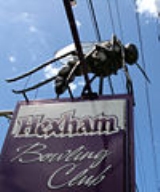
The Hexham Bowling Club provides a range of entertainment services for locals and travellers.
species Ochlerotatus alternans is common in the area and adults, famed for their size and ferocity, are referred to as "Hexham Greys". The most famous Hexham Grey is "Ossie the Mossie", (sometimes spelled as "Ozzie the Mozzie") a large model of a mosquito that sits atop the Hexham Bowling Club sign at the corner of the Pacific Highway and Old Maitland Road in Hexham. The previous "Ossie" was replaced with a new "Ossie" (pictured) in 2005. Ozzie disappeared from the sign in early February 2010 and was replaced in April 2010
City of Newcastle
Newcastle City Council is a Local Government Area in the Hunter Region of New South Wales, Australia.-Demographics:According to the Australian Bureau Statistics the City of Newcastle had an estimated resident population of 154,777 as of 30 June 2008...
, about 15 kilometres (9 mi) inland from Newcastle
Newcastle, New South Wales
The Newcastle metropolitan area is the second most populated area in the Australian state of New South Wales and includes most of the Newcastle and Lake Macquarie Local Government Areas...
in New South Wales
New South Wales
New South Wales is a state of :Australia, located in the east of the country. It is bordered by Queensland, Victoria and South Australia to the north, south and west respectively. To the east, the state is bordered by the Tasman Sea, which forms part of the Pacific Ocean. New South Wales...
, Australia
Australia
Australia , officially the Commonwealth of Australia, is a country in the Southern Hemisphere comprising the mainland of the Australian continent, the island of Tasmania, and numerous smaller islands in the Indian and Pacific Oceans. It is the world's sixth-largest country by total area...
on the bank of the Hunter River.
Settlement occurred at Hexham in the 1820s when the land was granted to Edward Sparke. Hexham was named after the market town of Hexham
Hexham
Hexham is a market town and civil parish in Northumberland, England, located south of the River Tyne, and was the administrative centre for the Tynedale district from 1974 to 2009. The three major towns in Tynedale were Hexham, Prudhoe and Haltwhistle, although in terms of population, Prudhoe was...
, England
England
England is a country that is part of the United Kingdom. It shares land borders with Scotland to the north and Wales to the west; the Irish Sea is to the north west, the Celtic Sea to the south west, with the North Sea to the east and the English Channel to the south separating it from continental...
with both towns being near to a Newcastle and sharing a history with one another; many of the coal miners from Newcastle upon Tyne
Newcastle upon Tyne
Newcastle upon Tyne is a city and metropolitan borough of Tyne and Wear, in North East England. Historically a part of Northumberland, it is situated on the north bank of the River Tyne...
and elsewhere in Northumberland
Northumberland
Northumberland is the northernmost ceremonial county and a unitary district in North East England. For Eurostat purposes Northumberland is a NUTS 3 region and is one of three boroughs or unitary districts that comprise the "Northumberland and Tyne and Wear" NUTS 2 region...
moved to New South Wales at the time of settlement.
The history of Hexham is closely associated with that of the nearby suburbs of Tarro (originally Upper Hexham), Ash Island, Tomago and Minmi.
Geography
Hexham measures approximately 6.7 km (4.2 mi) from north to south and 6 km (3.7 mi) from east to west, covering an area of 18.7 square kilometres (7.2 sq mi). The suburb is bordered to the east by the Hunter River and by Ironbark Creek to the south, while to the west the suburb consists mainly of unproductive swampland and floodplains. Almost all settlement exists within a narrow corridor stretching along the Pacific Highway between the Main North railway lineMain North railway line, New South Wales
The Main North Line is a major railway in New South Wales, Australia. It runs through the Central Coast, Hunter and the New England regions. The line was the original main line between Sydney and Brisbane, however this required a change of gauge at Wallangarra...
and the Hunter River. This corridor, which is occupied mainly by highways and industrial areas, covers an area of only 1.1 square kilometre (0.424712374451789 sq mi). Within the zone residential development is confined to 3 small areas measuring only 0.137 square kilometre (0.0528959957271773 sq mi) in total.
Roads
Hexham is located at the junction of the Pacific HighwayPacific Highway (Australia)
The Pacific Highway is a major transport route along part of the east coast of Australia and is part of Australia's national route 1.It is 960 km long and links Sydney, the capital of New South Wales, to Brisbane, the capital of Queensland, along the coast, via Gosford, Newcastle, Taree, Port...
to Brisbane
Brisbane
Brisbane is the capital and most populous city in the Australian state of Queensland and the third most populous city in Australia. Brisbane's metropolitan area has a population of over 2 million, and the South East Queensland urban conurbation, centred around Brisbane, encompasses a population of...
via the coastal route, the New England Highway
New England Highway
The New England Highway is a highway in Australia running from Hexham near Newcastle at its southern end to Yarraman near Toowoomba at its northern end. At its southern end it connects to the Pacific Highway and at its northern end it connects to the D'Aguilar Highway. It traverses the Hunter...
and is close to the northern end of the Sydney-Newcastle Freeway
Sydney-Newcastle Freeway
The Sydney-Newcastle Freeway is a stretch of motorway linking Sydney to the Central Coast, Newcastle and Hunter regions of New South Wales. It is part of the AusLink road corridor between Sydney and Brisbane, carrying the route designation....
. The Hunter Valley Dairy Co-operative took advantage of this key location to establish a large milkbar and take-away food complex (known as 'the Oak') to serve locals and longer distance travellers.
Hexham is located just upstream of the Hunter River delta and its various islands, and as such it was a relatively convenient place for crossing to the north bank of the river. A punt was established in the 1800s, followed by a steam punt, which eventually carried motor traffic. As traffic levels grew after World War I, Hexham became a bottleneck for road traffic. A decision was made in the late 1930s to construct a bridge, however construction was delayed by World War II. Eventually the first two-lane bridge was opened in December 1952. The first bridge is a steel truss bridge with a central lifting span, designed to allow shipping to travel upstream. By the 1970s, this bridge was also becoming a bottleneck and the decision was made to increase capacity by building a second bridge. This concrete bridge was built just upstream of the original bridge and was opened in August 1987.
Railways
Hexham has its own railway stationHexham railway station, New South Wales
-Neighbouring stations:- References :...
on the Main north line, which passes through the area. It was the riverine terminus of the Richmond Vale Railway line, an early coal hauling railway from Minmi
Minmi, New South Wales
Minmi is an outer western suburb of Newcastle, New South Wales, Australia, located from Newcastle's central business district. It is part of the City of Newcastle local government area....
and Stockrington. The wharf was later closed and the line was converted to join the main line to access the coal handling facilities in Newcastle.
Shipping
Hexham was once a riverport of some importance in the lower Hunter and was known as Port Hunter. In the colonial days travellers from Newcastle to Maitland could travel to Hexham by boat and then disembark to travel by road to Maitland via Upper Hexham (Tarro), Four Mile Creek and Green Hills, the road being more direct than the river which had many bends after Raymond Terrace.Coal loading at Hexham began about 1850.
One timber wharf was located on the south bank, immediately downstream of the first Hexham bridge. This was originally used by J & A Brown from the mid-1800s to load coal brought by train from Minimi across Hexham Swamp. The loader was later used by R W Miller. This loader has long ceased operating and has since been dismantled. The last ship was loaded in August 1988, the last in 138 years.
Another timber wharf was located on the south bank about 600 metres upstream from the current bridges across the Hunter River. This was near the Wheatsheaf Hotel, once operated by John Hannell, whose tomb is nearby. When it was constructed, the first Hexham bridge was built with a centre lifting span so small ships could travel to this wharf, even in the 1960s. (Similarly, the Stockton Bridge further downstream was built with a high arch so ships could travel upstream to Hexham by the north channel of the Hunter River to load coal at Hexham.) This wharf was eventually used by the Bellbird-Hetton Colliery to load coal. (It has a depot to the west, across the Pacific Highway and Great North Railway, at the end of what is now Woodlands Road.) This loader was later taken over by Peko-Wallsend in the 1960s, which also built six 600 ton coal silos (painted green) on the river bank and conveyors across the railway and highway to expedite loading. These facilities were demolished in the 1980-90s.
The ships serving Hexham were small and known as '60 milers', based on the distance they travelled to Sydney carrying coal for gas-making. In its later days, ships sometimes became stuck in th river travelling from Hexham.
Milk was also transported by small boats to the Hunter Valley Dairy Co-operative factory ('the Oak') after it was opened at Hexham in 1927.
Industries
Hexham's central location, with ready access to river, road and rail transport, has made it a key crossroads in the lower Hunter and influenced it industries. Originally it was a site of farming by the Sparke family. As a crossroads, hotels soon followed with three in operation in the 1800s: the Wheatsheaf, Hexham and Travellers Rest.Later it was a key locality for coal loading by J & A Brown and the Bellbird-Hetton Colliery. With coal loading came coal washeries and engineering workshops.
Its central location was again important to the establishment in 1927 of a dairy processing factory by the Hunter Valley Dairy Co-operative, which established the "OAK" milk brand, which is now owned by Parmalat
Parmalat
Parmalat SpA is a multinational Italian dairy and food corporation. Having become the leading global company in the production of ultra high temperature milk, the company collapsed in 2003 with a €14 billion hole in its accounts in what remains Europe's biggest bankruptcy...
. Its central location has seen the establishment of petrol stations, fast food outlets, warehouses and saleyards for heavy vechicles and caravans.
The Hexham Bowling Club provides a range of entertainment services for locals and travellers.
Mosquitoes
The mosquitoMosquito
Mosquitoes are members of a family of nematocerid flies: the Culicidae . The word Mosquito is from the Spanish and Portuguese for little fly...
species Ochlerotatus alternans is common in the area and adults, famed for their size and ferocity, are referred to as "Hexham Greys". The most famous Hexham Grey is "Ossie the Mossie", (sometimes spelled as "Ozzie the Mozzie") a large model of a mosquito that sits atop the Hexham Bowling Club sign at the corner of the Pacific Highway and Old Maitland Road in Hexham. The previous "Ossie" was replaced with a new "Ossie" (pictured) in 2005. Ozzie disappeared from the sign in early February 2010 and was replaced in April 2010