
Shire of Mundaring
Encyclopedia
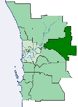
The Shire of Mundaring is a Local Government Area
on the eastern fringe of metropolitan Perth
, the capital of Western Australia
. The Shire covers an area of 645 square kilometres (249 sq mi) and has a population of 35,097 (2006).
Local Government Areas of Western Australia
The Australian state of Western Australia is divided into 141 local government areas...
on the eastern fringe of metropolitan Perth
Perth, Western Australia
Perth is the capital and largest city of the Australian state of Western Australia and the fourth most populous city in Australia. The Perth metropolitan area has an estimated population of almost 1,700,000....
, the capital of Western Australia
Western Australia
Western Australia is a state of Australia, occupying the entire western third of the Australian continent. It is bounded by the Indian Ocean to the north and west, the Great Australian Bight and Indian Ocean to the south, the Northern Territory to the north-east and South Australia to the south-east...
. The Shire covers an area of 645 square kilometres (249 sq mi) and has a population of 35,097 (2006).
History
The Greenmount Road District was created on 17 April 1903. On 29 March 1934, it was renamed Mundaring. On 1 July 1961, it became the Shire of Mundaring after enactment of the Local Government Act 1960.Statistics
Mundaring Shire has published the following statistics for the period 1994-2006 :- Population: 35,097
- Area: 643.32 km²
- Rateable area: 205.91 km²
- Rateable properties: 13,600
- Revenue: A$Australian dollarThe Australian dollar is the currency of the Commonwealth of Australia, including Christmas Island, Cocos Islands, and Norfolk Island, as well as the independent Pacific Island states of Kiribati, Nauru and Tuvalu...
17.4M - Vested reserves: 104.60 km²
- Forests and National Parks: 238.30 km²
Wards
The shire has been divided into 4 wards.- West Ward (2 councillors)
- South Ward (3 councillors)
- Central Ward (3 councillors)
- East Ward (3 councillors)
Suburbs and localities
At the 1996 ABS Census, Bailup, Gorrie and Malmalling were not identified as they were not created until 1999. Mundaring Weir was not listed as a separate locality.- BailupBailup, Western AustraliaBailup is a Western Australian locality and rural residential estate located north-east of the state capital, Perth, along Toodyay Road. The area is split between the Shire of Toodyay and Shire of Mundaring, the latter of which contains most of the land area....
- BellevueBellevue, Western AustraliaBellevue is an eastern suburb of Perth, Western Australia. Its Local Government Areas are the City of Swan and the Shire of Mundaring, and it is located at the foot of the slopes of Greenmount, a landmark on the Darling Scarp that is noted in the earliest of travel journals of the early Swan River...
- BeechinaBeechina, Western AustraliaBeechina is a locality in the Shire of Mundaring in Western Australia. The word "Beechina" is the Aboriginal name for a white gum valley to the northeast of the locality. It was first recorded by surveyor P. Chauncy in 1847, when he was carrying out the survey of the first road to Northam.-External...
- BoyaBoya, Western AustraliaBoya is a locality on the Darling Scarp, in the Shire of Mundaring, Western Australia. On the south side of Greenmount Hill, and just west of Darlington....
- ChidlowChidlow, Western AustraliaChidlow is a small community in the Shire of Mundaring approximately 45 kilometres east of Perth, Western Australia.-History:The Chidlow townsite was originally named Chidlow's Well after a small waterhole near the old Northam road. The watering place had been known to travellers for many years and...
- DarlingtonDarlington, Western AustraliaDarlington, Western Australia, is a locality in the Shire of Mundaring on the Darling Scarp, dissected by Nyaania Creek and north of the Helena River.- Location :...
- Glen ForrestGlen Forrest, Western AustraliaGlen Forrest is a suburb within the Shire of Mundaring, south of John Forrest National Park, west of Mahogany Creek, east of Darlington, and north of the Helena River...
- GreenmountGreenmount, Western AustraliaGreenmount is a locality and a geographical feature in the Shire of Mundaring, Western Australia, on the edge of the Darling Scarp. It is a vital point in the transport routes from the Swan Coastal Plain into the hinterland of Western Australia....
- Helena ValleyHelena Valley, Western AustraliaHelena Valley is the name of a river valley and a locality in the foothills of the Darling Scarp in Perth, Western Australia. It is located approximately 10 minutes from Midland.-Geology:...
- HoveaHovea, Western AustraliaHovea is a suburb in the Shire of Mundaring in Western Australia. It is bordered by the Railway Reserve Heritage Trail to the North, and Glen Forrest and the Great Eastern Highway to the south. The western boundary of this locality is the John Forrest National Park....
- Mahogany CreekMahogany Creek, Western AustraliaMahogany Creek is a suburb in the shire of Mundaring, Western Australia.Its name is derived from the historic Mahogany Creek Inn, constructed in about 1880, and situated on what was the York Road, now known as the Great Eastern Highway...
- MidvaleMidvale, Western AustraliaMidvale is a suburb of Perth, Western Australia, located mostly within the City of Swan, and partly within the Shire of Mundaring. Its postcode is 6056....
- Mount HelenaMount Helena, Western AustraliaMount Helena is a rural suburb on the outskirts of Perth in Western Australia, some 35 km from the city, in the Shire of Mundaring. Its population in 2005 was approximately 2,400 people.-History:...
- MundaringMundaring, Western AustraliaMundaring is a suburb located 34 km east of Perth on the Great Eastern Highway. The suburb is located within the Shire of Mundaring.The Aboriginal name of the area 'Mindah-lung', said to mean 'a high place on a high place', was anglicised to become 'Mundaring'.The Mundaring area is also considered...
- Mundaring Weir
- ParkervilleParkerville, Western AustraliaParkerville is a suburb in the Shire of Mundaring in Western Australia. Jane Brook flows through Parkerville on its way down to the Swan River through John Forrest National Park.-History:...
- Sawyers ValleySawyers Valley, Western AustraliaSawyers Valley is sited on the Great Eastern Highway about 40 kilometres from Perth, Western Australia in the Shire of Mundaring.The community began as a sawmill and railway siding to process timber from the forest surrounding the Helena River to the south...
- StonevilleStoneville, Western AustraliaStoneville is a suburb east of Perth in the Shire of Mundaring, Western Australia. It is named after Sir Albert Edward Stone, who was Chief Justice of Western Australia when the place was named in 1905. The name was chosen by the local residents who were developing the district for fruit growing...
- Swan ViewSwan View, Western AustraliaSwan View is an eastern suburb of Perth, Western Australia. Its Local Government Areas are the City of Swan and the Shire of Mundaring, and it is located from Perth in an area known as the Perth Hills on the edge of the Darling Scarp, just to the west of the John Forrest National Park, east of Roe...
- The LakesThe Lakes, Western AustraliaThe Lakes is a locality in Western Australia within the Shire of Mundaring. It is located east of the capital city of Perth at the junction of the Great Eastern Highway and the Great Southern Highway, and is the easternmost suburb within the Metropolitan Region Scheme...
- WoorolooWooroloo, Western AustraliaWooroloo is a town on the outer fringe of the Perth metropolitan area, located off Great Eastern Highway in the eastern part of the Shire of Mundaring. At the 2006 census, Wooroloo had a population of 254.-History:...
Population
| Year | Population |
|---|---|
| 1911 | 2,716 |
| 1921 | 3,296 |
| 1933 | 4,975 |
| 1947 | 6,072 |
| 1954 | 7,619 |
| 1961 | 8,104 |
| 1966 | 8,925 |
| 1971 | 12,018 |
| 1976 | 16,867 |
| 1981 | 20,786 |
| 1986 | 24,415 |
| 1991 | 29,184 |
| 1996 | 31,462 |
| 2001 | 33,281 |
| 2006 | 35,095 |