

Haugh of Urr
Encyclopedia
Haugh of Urr, is a village
in the Urr parish
, Kirkcudbrightshire
, in South West Scotland
. It is approximately 4 miles (6.4 km) NNW of Dalbeattie
, 3 miles (4.8 km) NE of Castle Douglas
, 12½ miles west of Dumfries
and 12½ miles east of Kirkcudbright
. It is pronounced hoch of ur, with Haugh rhyming with the Scottish
pronunciation of loch
.
'Haugh' or 'hauch' means river-meadow or a level piece of ground beside a stream. From the Old English halh, healh meaning corner, nook). It has one pub, the Laurie Arms which incorporates a part-time Post Office
, one Church (Church of Scotland), a Village Hall, a Scout
hut, and a small village green
. The village no longer has any shops. It used to have two shops, one of which included a petrol filling station, while the other included a full-time post office, which reduced to part time in later years. The last shop closed in 2009. Hardgate is a nearby hamlet
up the hill and the boundaries are indistinct. Agriculture and tourism are the mainstays of the local economy. The village is known to locals as "The Haugh".
fishing. The river originates at Glenlair
and flows for thirty miles from Loch Urr to its outflow into the Solway Firth
at Kippford
near Dalbeattie.
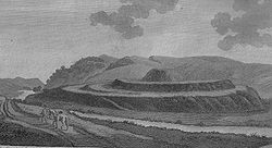 The Motte of Urr, is the site of a motte-and-bailey
castle. Today this medieval earthwork near the Haugh of Urr is said to be the most extensive bailey earthwork in Scotland. It lies beside the River Urr to the north west of Dalbeattie. It dates from the 12th century, and covers an area of about 2 ha (5 acres). In the present day, there are no excavations or walls. It is associated with Buittle
Castle, a courtyard castle dating to about 1230, which was destroyed early in the 14th century and belonged to Devorgilla and her husband John I de Balliol (founder of Balliol College, at Oxford University). Together they bore the future king John of Scotland
.
Village
A village is a clustered human settlement or community, larger than a hamlet with the population ranging from a few hundred to a few thousand , Though often located in rural areas, the term urban village is also applied to certain urban neighbourhoods, such as the West Village in Manhattan, New...
in the Urr parish
Parish
A parish is a territorial unit historically under the pastoral care and clerical jurisdiction of one parish priest, who might be assisted in his pastoral duties by a curate or curates - also priests but not the parish priest - from a more or less central parish church with its associated organization...
, Kirkcudbrightshire
Kirkcudbrightshire
The Stewartry of Kirkcudbright or Kirkcudbrightshire was a county of south-western Scotland. It was also known as East Galloway, forming the larger Galloway region with Wigtownshire....
, in South West Scotland
Scotland
Scotland is a country that is part of the United Kingdom. Occupying the northern third of the island of Great Britain, it shares a border with England to the south and is bounded by the North Sea to the east, the Atlantic Ocean to the north and west, and the North Channel and Irish Sea to the...
. It is approximately 4 miles (6.4 km) NNW of Dalbeattie
Dalbeattie
Dalbeattie is a town in Dumfries and Galloway , Scotland.Dalbeattie is situated in a wooded valley on the Urr Water east of Castle Douglas and south west of Dumfries...
, 3 miles (4.8 km) NE of Castle Douglas
Castle Douglas
Castle Douglas , a town in the south of Scotland in Dumfries and Galloway, lies in the eastern part of Galloway known as the Stewartry, between the towns of Dalbeattie and Gatehouse of Fleet.-History:...
, 12½ miles west of Dumfries
Dumfries
Dumfries is a market town and former royal burgh within the Dumfries and Galloway council area of Scotland. It is near the mouth of the River Nith into the Solway Firth. Dumfries was the county town of the former county of Dumfriesshire. Dumfries is nicknamed Queen of the South...
and 12½ miles east of Kirkcudbright
Kirkcudbright
Kirkcudbright, is a town in Dumfries and Galloway, Scotland.The town lies south of Castle Douglas and Dalbeattie, in the part of Dumfries and Galloway known as the Stewartry, at the mouth of the River Dee, some six miles from the sea...
. It is pronounced hoch of ur, with Haugh rhyming with the Scottish
Scots language
Scots is the Germanic language variety spoken in Lowland Scotland and parts of Ulster . It is sometimes called Lowland Scots to distinguish it from Scottish Gaelic, the Celtic language variety spoken in most of the western Highlands and in the Hebrides.Since there are no universally accepted...
pronunciation of loch
Loch
Loch is the Irish and Scottish Gaelic word for a lake or a sea inlet. It has been anglicised as lough, although this is pronounced the same way as loch. Some lochs could also be called a firth, fjord, estuary, strait or bay...
.
| Town | Local authority | Co-ordinates | OS Ordnance Survey Ordnance Survey , an executive agency and non-ministerial government department of the Government of the United Kingdom, is the national mapping agency for Great Britain, producing maps of Great Britain , and one of the world's largest producers of maps.The name reflects its creation together with... grid reference British national grid reference system The Ordnance Survey National Grid reference system is a system of geographic grid references used in Great Britain, different from using latitude and longitude.... |
| Haugh of Urr | Dumfries and Galloway | 54.97°N 03.87°W |
Description
The village is situated beside the River Urr. (ScotsScots language
Scots is the Germanic language variety spoken in Lowland Scotland and parts of Ulster . It is sometimes called Lowland Scots to distinguish it from Scottish Gaelic, the Celtic language variety spoken in most of the western Highlands and in the Hebrides.Since there are no universally accepted...
'Haugh' or 'hauch' means river-meadow or a level piece of ground beside a stream. From the Old English halh, healh meaning corner, nook). It has one pub, the Laurie Arms which incorporates a part-time Post Office
Post office
A post office is a facility forming part of a postal system for the posting, receipt, sorting, handling, transmission or delivery of mail.Post offices offer mail-related services such as post office boxes, postage and packaging supplies...
, one Church (Church of Scotland), a Village Hall, a Scout
Scouting
Scouting, also known as the Scout Movement, is a worldwide youth movement with the stated aim of supporting young people in their physical, mental and spiritual development, that they may play constructive roles in society....
hut, and a small village green
Village green
A village green is a common open area which is a part of a settlement. Traditionally, such an area was often common grass land at the centre of a small agricultural settlement, used for grazing and sometimes for community events...
. The village no longer has any shops. It used to have two shops, one of which included a petrol filling station, while the other included a full-time post office, which reduced to part time in later years. The last shop closed in 2009. Hardgate is a nearby hamlet
Hamlet
The Tragical History of Hamlet, Prince of Denmark, or more simply Hamlet, is a tragedy by William Shakespeare, believed to have been written between 1599 and 1601...
up the hill and the boundaries are indistinct. Agriculture and tourism are the mainstays of the local economy. The village is known to locals as "The Haugh".
River Urr
The River Urr is noted for salmonSalmon
Salmon is the common name for several species of fish in the family Salmonidae. Several other fish in the same family are called trout; the difference is often said to be that salmon migrate and trout are resident, but this distinction does not strictly hold true...
fishing. The river originates at Glenlair
Glenlair
Glenlair House, near the village of Corsock in the Scottish Council area of Dumfries and Galloway, was the home of the physicist James Clerk Maxwell . The original structure was designed for Maxwell's father by Walter Newall; Maxwell himself oversaw the construction of an extension in the late...
and flows for thirty miles from Loch Urr to its outflow into the Solway Firth
Solway Firth
The Solway Firth is a firth that forms part of the border between England and Scotland, between Cumbria and Dumfries and Galloway. It stretches from St Bees Head, just south of Whitehaven in Cumbria, to the Mull of Galloway, on the western end of Dumfries and Galloway. The Isle of Man is also very...
at Kippford
Kippford
Kippford is a small village along the Solway coast, in Dumfries and Galloway, Scotland.-Geography:Kippford stretches along the banks of the Urr estuary and in places is only one house wide, being hemmed in between the forested Mark hill and the sea...
near Dalbeattie.
Motte of Urr
Motte-and-bailey
A motte-and-bailey is a form of castle, with a wooden or stone keep situated on a raised earthwork called a motte, accompanied by an enclosed courtyard, or bailey, surrounded by a protective ditch and palisade...
castle. Today this medieval earthwork near the Haugh of Urr is said to be the most extensive bailey earthwork in Scotland. It lies beside the River Urr to the north west of Dalbeattie. It dates from the 12th century, and covers an area of about 2 ha (5 acres). In the present day, there are no excavations or walls. It is associated with Buittle
Buittle
Buittle is an ecclesiastical and former civil parish in the Stewartry of Kirkcudbright in the South West of Scotland.-History:The name is ancient, as it is derived from the Northumbrian term boðl, settlement or Hamlet. Northumbrian expansion into what was the kingdoms of Rheged and Strathclyde in...
Castle, a courtyard castle dating to about 1230, which was destroyed early in the 14th century and belonged to Devorgilla and her husband John I de Balliol (founder of Balliol College, at Oxford University). Together they bore the future king John of Scotland
John of Scotland
John Balliol , known to the Scots as Toom Tabard , was King of Scots from 1292 to 1296.-Early life:Little of John's early life is known. He was born between 1248 and 1250 at an unknown location, possibilities include Galloway, Picardy and Barnard Castle, County Durham...
.
External links
- Overview of the village http://www.scottish-places.info/towns/townfirst3245.html
- Urr parish church http://www.dlbteparishch.f9.co.uk/page15.html
- Parish information http://www.genuki.org.uk/big/sct/KKD/Urr/
- Vale of Urr http://www.glenlair.org.uk/vale_of_the_urr.asp
- Unpublished records for the parish of Urr in Kirkcudbrighshire http://donjaggi.net/galloway/index.html
- River Urr http://www.glenlair.org.uk/river_urr.asp
- River Urr http://www.geograph.org.uk/photo/425690
- Motte of Urr http://www.scottish-places.info/features/featurefirst8406.html
- Motte of Urr http://thereformation.info/motte.htm
- Buittle Castle http://www.rcahms.gov.uk/pls/portal/newcanmore.details_gis?inumlink=65002