

Hartford, Tennessee
Encyclopedia
Hartford is an unincorporated community
in Cocke County, Tennessee
, located in the southeastern United States
. Although it is not a census-designated place
, the ZIP Code Tabulation Area
for the ZIP Code
(37753) that serves Hartford had a population of 814, according to the 2000 census
.
Hartford is the easternmost town in Tennessee along Interstate 40
, and thus acts as the state's "gateway" by helping to maintain the Tennessee Welcome Center. The town is located at the northeastern tip of the Great Smoky Mountains
and lies within the Cherokee National Forest
.
of 2000, there were 814 people, 333 households, and 226 families residing in the Zip Code Tabulation Area for zip code 37753, which serves Hartford. The racial makeup of the ZCTA was 98.2% White, 0.1% Native American, 0.1% Asian, and 1.6% from two or more races. Hispanic and Latino of any race were 1.4% of the population.
There were 333 households out of which 27.0% had children under the age of 18 living with them, 48.3% were married couples
living together, 13.8% had a female householder with no husband present, and 32.1% were non-families. The average household size was 2.44 and the average family size was 2.94.
78.9% of the population was 18 years of age or older with 13.6% being 65 years of age or older. The median age was 39.9 years. The population was 53.1% male and 46.9% female.
The median income for a household in ZCTA 37753 was $20,357, and the median income for a family was $25,185. The per capita income
for the ZCTA was $10,684. About 23.0% of families and 29.8% of the population were below the poverty line.
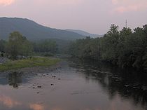
 Hartford is located at 35°49′0"N 83°8′36"W (35.816670, -83.143330). The community is situated in a narrow valley along the Pigeon River
, which flows from its source high in the Blue Ridge Mountains
down into the flatlands of Cocke County. The river's valley divides the Great Smokies crest to the southwest from the Snowbird massif
to the northeast.
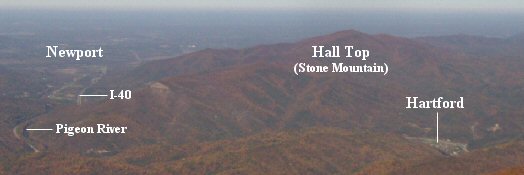
Hartford is surrounded by mountains on all sides, with Snowbird Mountain rising some 4,200 feet to the east and Mount Cammerer
— the eastern most of the Great Smokies
— rising nearly 5,000 feet to the south. To the west, Foothills Parkway
traverses Green Mountain, connecting the Pigeon Valley to Cosby, Tennessee
. Stone Mountain, commonly called Hall Top, dominates the area to the north.
Interstate 40, which passes through Hartford, follows the Pigeon River Valley between Cocke County and Haywood County, North Carolina
. Along I-40, Hartford is located roughly halfway between Knoxville, Tennessee
and Asheville, North Carolina
.
 The first known permanent settler in what is now Hartford was Solomon Williams, who arrived in the area in 1853. He was followed shortly thereafter by Moses Clark, who would donate the land upon which a log meeting house was built. For much of the 19th century, this meeting house was used for various functions, including church services and school. In this period, the community was known simply as Pigeon Valley. Hartford's Pigeon Valley Church, organized in 1889, still bears the town's old name.
Like many Appalachia
n communities, Pigeon Valley thrived during the logging boom of the late 19th century. Innovations such as the band saw
and high demand for wood led lumber companies to seek out the dense forests of the Appalachian Mountains for timber. The Scottish-Carolina Timber and Land Company, which had established a foothold in the region through its American agent Alexander Arthur
(1846–1912), was among the first to harvest the trees in the Pigeon Valley area, which they moved downstream via river current to the A.C. Lawrence Leather Company factory in Newport. The leather company used the trees' bark in the tanning
process. The Scottish Lumber venture lasted for roughly six years. In 1886, a massive flood on the Pigeon River scattered the company's stock of logs, and the company was forced to shut down operations.
In 1917, the Boice Hardwood Company erected a band mill at Hartford with plans to log the river's north bank all the way to Max Patch
Mountain. Hartford quickly developed into a company town, situated around the band mill. Mary Bell Smith, who lived in Hartford during this period, recalls:
As the mill prospered in the 1920s Hartford grew to include several frame houses, a general store, a post office, a school, and a movie theater. The sawmill's generators even provided electricity to the town from 5am to 10pm. Converts trickled into the old Pigeon Valley Church. Smith recalled a baptism held in Hartford in the dead of winter in 1925:
With the onset of the Great Depression in the early 1930s, the timber market dried up, and Boice Hardwood was forced to close. Hartford wouldn't recover economically until the construction of I-40 through the town in the 1960s.
 While the various lumber industries along the Pigeon River brought at least temporary prosperity to many of the valley's communities, the long-term effects of the mills' use of the river for waste dumping eventually began to take its toll.
In 1908, Champion International (then known as the Champion Fibre Company)— which had bought up large tracts of forest in the Smokies— established a paper mill in Canton, North Carolina
(upstream from Hartford). Over the next few decades, Champion, like other industries along the Pigeon, used the river to dispose of its industrial waste.
Throughout the 20th century, the Pigeon River Valley experienced a relatively high rate of cancer and other toxin-related deaths. Hartford itself was hit particularly hard, earning the nickname "Widowville." Environmentalists blamed the high cancer rate on the unusually high levels of dioxin in the tissue of fish living in the river. After it was determined that Champion's Canton mill was the primary source of the excessive dioxin levels, the Environmental Protection Agency
began to pressure the paper manufacturer to reduce its dioxin emissions. The debate reached a high point in 1988, when then-Senator Al Gore— who was seeking the Democratic presidential nomination— intervened on behalf of Champion. As Gore is normally pro-environment, many saw this move as hypocritical, and accused Gore of selling out the Pigeon Valley in order to gain much-needed primary votes in North Carolina.
In spite of Gore's apparent snub, pressure from environmental groups continued, and Champion began taking measures to drastically reduce dioxin emissions in the early 1990s. By 1994, Champion had spent $330 million modernizing its plant before new regulations forced the company to sell the plant in 1999. Starting in 2002, the paper mill's new owner, the Blue Ridge Paper Company, spent $22 million to clean up the river. The measures taken by Champion and Blue Ridge Paper led to a 99% reduction in the river's dioxin levels, and in early 2007, state advisory boards deemed fish caught in the Pigeon River safe for consumption.
 Along with being one of the few refueling stops along the 60-mile stretch of I-40 between Newport and Waynesville, North Carolina
, Hartford has managed to take advantage of its position along a relatively rapid leg of the Pigeon River to attract whitewater rafting enthusiasts. The town is also home to a log cabin construction company.
, Tennessee or Cocke County High School in Newport.
Unincorporated area
In law, an unincorporated area is a region of land that is not a part of any municipality.To "incorporate" in this context means to form a municipal corporation, a city, town, or village with its own government. An unincorporated community is usually not subject to or taxed by a municipal government...
in Cocke County, Tennessee
Tennessee
Tennessee is a U.S. state located in the Southeastern United States. It has a population of 6,346,105, making it the nation's 17th-largest state by population, and covers , making it the 36th-largest by total land area...
, located in the southeastern United States
United States
The United States of America is a federal constitutional republic comprising fifty states and a federal district...
. Although it is not a census-designated place
Census-designated place
A census-designated place is a concentration of population identified by the United States Census Bureau for statistical purposes. CDPs are delineated for each decennial census as the statistical counterparts of incorporated places such as cities, towns and villages...
, the ZIP Code Tabulation Area
ZIP Code Tabulation Area
ZIP Code Tabulation Areas are statistical entities developed by the United States Census Bureau for tabulating summary statistics from Census 2000. This new entity was developed to overcome the difficulties in precisely defining the land area covered by each ZIP code...
for the ZIP Code
ZIP Code
ZIP codes are a system of postal codes used by the United States Postal Service since 1963. The term ZIP, an acronym for Zone Improvement Plan, is properly written in capital letters and was chosen to suggest that the mail travels more efficiently, and therefore more quickly, when senders use the...
(37753) that serves Hartford had a population of 814, according to the 2000 census
United States Census, 2000
The Twenty-second United States Census, known as Census 2000 and conducted by the Census Bureau, determined the resident population of the United States on April 1, 2000, to be 281,421,906, an increase of 13.2% over the 248,709,873 persons enumerated during the 1990 Census...
.
Hartford is the easternmost town in Tennessee along Interstate 40
Interstate 40
Interstate 40 is the third-longest major east–west Interstate Highway in the United States, after I-90 and I-80. Its western end is at Interstate 15 in Barstow, California; its eastern end is at a concurrency of U.S. Route 117 and North Carolina Highway 132 in Wilmington, North Carolina...
, and thus acts as the state's "gateway" by helping to maintain the Tennessee Welcome Center. The town is located at the northeastern tip of the Great Smoky Mountains
Great Smoky Mountains
The Great Smoky Mountains are a mountain range rising along the Tennessee–North Carolina border in the southeastern United States. They are a subrange of the Appalachian Mountains, and form part of the Blue Ridge Physiographic Province. The range is sometimes called the Smoky Mountains or the...
and lies within the Cherokee National Forest
Cherokee National Forest
The Cherokee National Forest is a large National Forest created on July 19, 1936, by U.S. President Franklin Roosevelt, operated by the U.S. Forest Service and encompassing some 640,000 acres .-Location:...
.
Demographics
As of the censusCensus
A census is the procedure of systematically acquiring and recording information about the members of a given population. It is a regularly occurring and official count of a particular population. The term is used mostly in connection with national population and housing censuses; other common...
of 2000, there were 814 people, 333 households, and 226 families residing in the Zip Code Tabulation Area for zip code 37753, which serves Hartford. The racial makeup of the ZCTA was 98.2% White, 0.1% Native American, 0.1% Asian, and 1.6% from two or more races. Hispanic and Latino of any race were 1.4% of the population.
There were 333 households out of which 27.0% had children under the age of 18 living with them, 48.3% were married couples
Marriage
Marriage is a social union or legal contract between people that creates kinship. It is an institution in which interpersonal relationships, usually intimate and sexual, are acknowledged in a variety of ways, depending on the culture or subculture in which it is found...
living together, 13.8% had a female householder with no husband present, and 32.1% were non-families. The average household size was 2.44 and the average family size was 2.94.
78.9% of the population was 18 years of age or older with 13.6% being 65 years of age or older. The median age was 39.9 years. The population was 53.1% male and 46.9% female.
The median income for a household in ZCTA 37753 was $20,357, and the median income for a family was $25,185. The per capita income
Per capita income
Per capita income or income per person is a measure of mean income within an economic aggregate, such as a country or city. It is calculated by taking a measure of all sources of income in the aggregate and dividing it by the total population...
for the ZCTA was $10,684. About 23.0% of families and 29.8% of the population were below the poverty line.
Geography
Pigeon River (Tennessee - North Carolina)
The Pigeon River of western North Carolina and east Tennessee rises above Canton, North Carolina. Below this, it flows roughly parallel to Interstate 40 for many miles and is impounded by a dam -- Walters Dam -- belonging to Progress Energy before entering Tennessee, where it flows into the French...
, which flows from its source high in the Blue Ridge Mountains
Blue Ridge Mountains
The Blue Ridge Mountains are a physiographic province of the larger Appalachian Mountains range. This province consists of northern and southern physiographic regions, which divide near the Roanoke River gap. The mountain range is located in the eastern United States, starting at its southern-most...
down into the flatlands of Cocke County. The river's valley divides the Great Smokies crest to the southwest from the Snowbird massif
Massif
In geology, a massif is a section of a planet's crust that is demarcated by faults or flexures. In the movement of the crust, a massif tends to retain its internal structure while being displaced as a whole...
to the northeast.
Hartford is surrounded by mountains on all sides, with Snowbird Mountain rising some 4,200 feet to the east and Mount Cammerer
Mount Cammerer
Mount Cammerer is a mountain on the northeastern fringe of the Great Smoky Mountains, in the Southeastern United States. The mountain is situated on the state line between Cocke County, Tennessee and Haywood County, North Carolina...
— the eastern most of the Great Smokies
Great Smoky Mountains
The Great Smoky Mountains are a mountain range rising along the Tennessee–North Carolina border in the southeastern United States. They are a subrange of the Appalachian Mountains, and form part of the Blue Ridge Physiographic Province. The range is sometimes called the Smoky Mountains or the...
— rising nearly 5,000 feet to the south. To the west, Foothills Parkway
Foothills Parkway
The Foothills Parkway is a national parkway which, if completed, will traverse the foothills of the northern Great Smoky Mountains in East Tennessee, located in the Southeastern United States. The 71-mile parkway will ideally connect U.S...
traverses Green Mountain, connecting the Pigeon Valley to Cosby, Tennessee
Cosby, Tennessee
Cosby is an unincorporated community in Cocke County, Tennessee, United States. Although it is not a census-designated place, the ZIP Code Tabulation Area for the ZIP Code that serves Cosby had a population of 5,201 as of the 2000 U.S. Census...
. Stone Mountain, commonly called Hall Top, dominates the area to the north.
Interstate 40, which passes through Hartford, follows the Pigeon River Valley between Cocke County and Haywood County, North Carolina
Haywood County, North Carolina
-National protected areas:* Blue Ridge Parkway * Great Smoky Mountains National Park * Pisgah National Forest -Major Highways & Roads:* Interstate 40* U.S. Highway 19* U.S. Highway 23* U.S. Highway 74* U.S...
. Along I-40, Hartford is located roughly halfway between Knoxville, Tennessee
Knoxville, Tennessee
Founded in 1786, Knoxville is the third-largest city in the U.S. state of Tennessee, U.S.A., behind Memphis and Nashville, and is the county seat of Knox County. It is the largest city in East Tennessee, and the second-largest city in the Appalachia region...
and Asheville, North Carolina
Asheville, North Carolina
Asheville is a city in and the county seat of Buncombe County, North Carolina, United States. It is the largest city in Western North Carolina, and the 11th largest city in North Carolina. The City is home to the United States National Climatic Data Center , which is the world's largest active...
.
History
Like many Appalachia
Appalachia
Appalachia is a term used to describe a cultural region in the eastern United States that stretches from the Southern Tier of New York state to northern Alabama, Mississippi, and Georgia. While the Appalachian Mountains stretch from Belle Isle in Canada to Cheaha Mountain in the U.S...
n communities, Pigeon Valley thrived during the logging boom of the late 19th century. Innovations such as the band saw
Band saw
A bandsaw is a power tool which uses a blade consisting of a continuous band of metal with teeth along one edge to cut various workpieces. The band usually rides on two wheels rotating in the same plane, although some small bandsaws have three wheels. Bandsawing produces uniform cutting action as a...
and high demand for wood led lumber companies to seek out the dense forests of the Appalachian Mountains for timber. The Scottish-Carolina Timber and Land Company, which had established a foothold in the region through its American agent Alexander Arthur
Alexander Arthur
Alexander Alan Arthur was a Scottish-born engineer and entrepreneur active primarily in the southeastern United States in the latter half of the 19th century...
(1846–1912), was among the first to harvest the trees in the Pigeon Valley area, which they moved downstream via river current to the A.C. Lawrence Leather Company factory in Newport. The leather company used the trees' bark in the tanning
Tanning
Tanning is the making of leather from the skins of animals which does not easily decompose. Traditionally, tanning used tannin, an acidic chemical compound from which the tanning process draws its name . Coloring may occur during tanning...
process. The Scottish Lumber venture lasted for roughly six years. In 1886, a massive flood on the Pigeon River scattered the company's stock of logs, and the company was forced to shut down operations.
Early 1900s
Pigeon Valley was given the name "Hartford" in honor of John Hart, co-owner of the Tennessee & North Carolina Railroad who supervised the construction of a line through the valley connecting Newport and Waterville.In 1917, the Boice Hardwood Company erected a band mill at Hartford with plans to log the river's north bank all the way to Max Patch
Max Patch
Max Patch is a bald mountain on the North Carolina-Tennessee Border in Madison County, North Carolina and Cocke County, Tennessee. It is a major landmark along the Tennessee/North Carolina section of the Appalachian Trail, although its summit is located in North Carolina...
Mountain. Hartford quickly developed into a company town, situated around the band mill. Mary Bell Smith, who lived in Hartford during this period, recalls:
Every morning Hartford came to life at five o'clock with the shrill whistle from the sawmill that signaled the new day. Before dawn, the big steam boiler began belching out the steam which operated the sawmill for another day. The bandsaw hummed, the cut-off saw screeched, and the drag-chain rumbled as it carried trash, cull lumber, and sawdust up the conveyor to the blazing furnace.
As the mill prospered in the 1920s Hartford grew to include several frame houses, a general store, a post office, a school, and a movie theater. The sawmill's generators even provided electricity to the town from 5am to 10pm. Converts trickled into the old Pigeon Valley Church. Smith recalled a baptism held in Hartford in the dead of winter in 1925:
At two o'clock that Sunday afternoon, Rev. Hall walked into the Pigeon River, pushing away mushy ice as he walked. Wading far enough out into the river for the water to reach about waist high, he prepared himself for the baptismal service. We spectators watched with steamy breath from the river banks as the newly converted believers were momentarily buried in the icy waters.
With the onset of the Great Depression in the early 1930s, the timber market dried up, and Boice Hardwood was forced to close. Hartford wouldn't recover economically until the construction of I-40 through the town in the 1960s.
The Pigeon River Pollution Controversy
In 1908, Champion International (then known as the Champion Fibre Company)— which had bought up large tracts of forest in the Smokies— established a paper mill in Canton, North Carolina
Canton, North Carolina
Canton is the second largest town in Haywood County, North Carolina, United States. It is located about west of Asheville, North Carolina and is part of the Asheville Metropolitan Statistical Area. The town is named after the city of Canton, Ohio.- History :...
(upstream from Hartford). Over the next few decades, Champion, like other industries along the Pigeon, used the river to dispose of its industrial waste.
Throughout the 20th century, the Pigeon River Valley experienced a relatively high rate of cancer and other toxin-related deaths. Hartford itself was hit particularly hard, earning the nickname "Widowville." Environmentalists blamed the high cancer rate on the unusually high levels of dioxin in the tissue of fish living in the river. After it was determined that Champion's Canton mill was the primary source of the excessive dioxin levels, the Environmental Protection Agency
United States Environmental Protection Agency
The U.S. Environmental Protection Agency is an agency of the federal government of the United States charged with protecting human health and the environment, by writing and enforcing regulations based on laws passed by Congress...
began to pressure the paper manufacturer to reduce its dioxin emissions. The debate reached a high point in 1988, when then-Senator Al Gore— who was seeking the Democratic presidential nomination— intervened on behalf of Champion. As Gore is normally pro-environment, many saw this move as hypocritical, and accused Gore of selling out the Pigeon Valley in order to gain much-needed primary votes in North Carolina.
In spite of Gore's apparent snub, pressure from environmental groups continued, and Champion began taking measures to drastically reduce dioxin emissions in the early 1990s. By 1994, Champion had spent $330 million modernizing its plant before new regulations forced the company to sell the plant in 1999. Starting in 2002, the paper mill's new owner, the Blue Ridge Paper Company, spent $22 million to clean up the river. The measures taken by Champion and Blue Ridge Paper led to a 99% reduction in the river's dioxin levels, and in early 2007, state advisory boards deemed fish caught in the Pigeon River safe for consumption.
Hartford Today
Waynesville, North Carolina
Waynesville is a town in and the county seat of Haywood County, North Carolina, United States. It is the largest town in Haywood County and the largest in Western North Carolina west of Asheville. Waynesville is located about or 50 km southwest of Asheville between the Great Smoky and Blue...
, Hartford has managed to take advantage of its position along a relatively rapid leg of the Pigeon River to attract whitewater rafting enthusiasts. The town is also home to a log cabin construction company.
School Systems
The only school in the city is Grassy Fork Elementary http://www.cocke.k12.tn.us/grassyfork/index.htm School. Grassy Fork is a Kindergarten through 8th Grade School. For high school most students will attend Cosby High School in the neighboring city of CosbyCosby, Tennessee
Cosby is an unincorporated community in Cocke County, Tennessee, United States. Although it is not a census-designated place, the ZIP Code Tabulation Area for the ZIP Code that serves Cosby had a population of 5,201 as of the 2000 U.S. Census...
, Tennessee or Cocke County High School in Newport.
External links
- Hartford, Tennessee — Cocke County Chamber of Commerce profile