
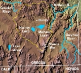
Harney Basin
Encyclopedia
The Harney Basin is a structural basin in southeastern Oregon
in the United States
at the northwestern corner of the Great Basin
. One of the least populated areas of the contiguous United States
, it is located largely in northern Harney County
, bounded on the north and east by the Columbia Plateau
, within which it is contained, physiographically speaking, and on the south and west by a volcanic
plain. The basin encompasses an area of 5300 mi2 in the watershed of Malheur Lake
and Harney Lake
. Malheur Lake is a freshwater lake, while Harney Lake is saline-alkaline.
The basin is bounded on the north by the southern end of the Blue Mountains
. The ridge of Steens Mountain
separates the basin from the watershed of the Alvord Desert
to the southeast. No streams cross the volcanic plains that separate the basin from the watershed of the Klamath River
to the southwest. The basin includes archeological sites of the Drewsey Resource Area.
from the north and the Donner und Blitzen River
from the south.Harney Lake is the actual sink of the basin, connected in some years to Malheur Lake but currently separated by constantly changing sand dunes. Both lakes cycle between open water in wetter years and marshes in drier years. The wetlands around Malheur Lake and Harney Lake form a wetlands oasis in the basin, providing a habitat
for many migratory bird
species, including 2.5 million duck
s each year. Malheur Lake and its surroundings are embraced by Malheur National Wildlife Refuge
.
Harney County, Oregon
, has a total population of 7,609, and Burns
in the plain north of Malheur Lake is the only community with a population larger than 1,000. Dryland ranching is the basis of the area's economy, with relatively little irrigation
water available from the streams that enter Malheur Lake.
. The field is within the High Lava Plains Province.http://books.google.com/books?id=Cy9ErSxZFhQC&pg=PA296
watershed of 765 sq mi (1,981.3 km²) discharges into Malheur Lake and includes the river portion of the 292 sq mi (756.3 km²) Malheur National Wildlife Refuge
. "Alkali Field is located directly south of Malheur Lake, a few kilometers east of the Donner und Blitzen River."
The High Desert Wetlands ecoregion is a set of Northern Basin and Range
wetlands with 1651 sq mi (4,276.1 km²) in Oregon, including a large area around Harney and Malheur Lake
s.
flows formed the Malheur Gap, separating the watershed of the basin from the Malheur River
, a tributary of the Snake River. Archaeological evidence indicates the basin was inhabited as early as 10,000 years ago. Pollen records indicate that the climate, especially the level of rain and snowfall, has varied greatly since the end of the Pleistocene
. Evidence of prehistoric fishing techniques is found at several sites. Evidence suggests that there existed in the basin several species—in particular the chiselmouth
, coarse-scale sucker
s, and northern squawfish
—that are currently found only in the Columbia River
basin, indicating that at some point the Harney Basin may have been connected to the Columbia. During wetter years, the lake level of Malheur Lake was raised to a depth of 25 ft (7.5 m), allowing the lakes to drain over the Malheur Gap. In modern times, however, the lake level does not rise above 10 ft (3 m) in the wettest years.
In the 19th century the basin was inhabited by the Northern Paiute tribe. It was explored and extensively trapped by trappers
of the Hudson's Bay Company
in the 1820s. The basin lay far off the route of the Oregon Trail
, but in 1843 experienced mountain man Stephen Meek
led an ill-fated party across the basin via Stinkingwater Pass, seeking a shortcut to The Dalles
along what has become known as the Meek Cutoff. A total of 23 people died while the party wandered in the basin until finding water at the Crooked River
.
Because of its climate it received sparse white settlement and was largely left to the Paiute until the late 19th century. Settlement pressures and conflicts with the Paiute in other ares of Oregon caused President Ulysses S. Grant
in 1872 to create a reservation for the Paiute
encompassing Malheur Lake and much of the basin. Growing settlement pressures, in particular the discovery of gold
in the surrounding mountains, as well as the interest of white settlers to form ranches in the region, caused the Commissioner of Indian Affairs to abruptly terminate the reservation in 1879. The Northern Paiute would survive virtually landless until obtaining tracts of land near Burns in 1935.
Oregon
Oregon is a state in the Pacific Northwest region of the United States. It is located on the Pacific coast, with Washington to the north, California to the south, Nevada on the southeast and Idaho to the east. The Columbia and Snake rivers delineate much of Oregon's northern and eastern...
in the United States
United States
The United States of America is a federal constitutional republic comprising fifty states and a federal district...
at the northwestern corner of the Great Basin
Great Basin
The Great Basin is the largest area of contiguous endorheic watersheds in North America and is noted for its arid conditions and Basin and Range topography that varies from the North American low point at Badwater Basin to the highest point of the contiguous United States, less than away at the...
. One of the least populated areas of the contiguous United States
Contiguous United States
The contiguous United States are the 48 U.S. states on the continent of North America that are south of Canada and north of Mexico, plus the District of Columbia....
, it is located largely in northern Harney County
Harney County, Oregon
-National protected areas:*Malheur National Forest *Malheur National Wildlife Refuge*Ochoco National Forest -Demographics:As of the census of 2000, there were 7,609 people, 3,036 households, and 2,094 families residing in the county. The population density was 1 people per square mile...
, bounded on the north and east by the Columbia Plateau
Columbia Plateau
The Columbia Plateau is a geologic and geographic region that lies across parts of the U.S. states of Washington, Oregon, and Idaho. It is a wide flood basalt plateau between the Cascade Range and the Rocky Mountains, cut through by the Columbia River...
, within which it is contained, physiographically speaking, and on the south and west by a volcanic
Volcano
2. Bedrock3. Conduit 4. Base5. Sill6. Dike7. Layers of ash emitted by the volcano8. Flank| 9. Layers of lava emitted by the volcano10. Throat11. Parasitic cone12. Lava flow13. Vent14. Crater15...
plain. The basin encompasses an area of 5300 mi2 in the watershed of Malheur Lake
Malheur Lake
Malheur Lake is a lake in an arid region of eastern Oregon, United States near Burns, Oregon. The lake is fed by Donner und Blitzen River from the south and the Silvies River from the north. Malheur Lake has no outlet, though water escapes through ground seepage and by evaporation; widespread...
and Harney Lake
Harney Lake
Harney Lake is a shallow alkali lake basin located in southeast Oregon, United States, approximately thirty miles south of the town of Burns. The lake lies within the boundary of the Malheur National Wildlife Refuge and is the lowest point in the Blitzen Valley drainage.- History :The lake has been...
. Malheur Lake is a freshwater lake, while Harney Lake is saline-alkaline.
The basin is bounded on the north by the southern end of the Blue Mountains
Blue Mountains (Oregon)
The Blue Mountains are a mountain range in the western United States, located largely in northeastern Oregon and stretching into southeastern Washington...
. The ridge of Steens Mountain
Steens Mountain
Steens Mountain is a large fault-block mountain in the southeastern part of the U.S. state of Oregon. Located in Harney County, it stretches some and rises from an elevation of about above the Alvord Desert to its peak at...
separates the basin from the watershed of the Alvord Desert
Alvord Desert
The Alvord Desert is a desert located in Harney County, in southeastern Oregon in the western United States. It is roughly southeast of Steens Mountain. The Alvord Desert is a dry lake bed and averages of rain a year. Two mountain ranges separate it from the Pacific Ocean—the Coast Range, and...
to the southeast. No streams cross the volcanic plains that separate the basin from the watershed of the Klamath River
Klamath River
The Klamath River is an American river that flows southwest through Oregon and northern California, cutting through the Cascade Range to empty into the Pacific Ocean. The river drains an extensive watershed of almost that stretches from the high desert country of the Great Basin to the temperate...
to the southwest. The basin includes archeological sites of the Drewsey Resource Area.
Geography
The central basin receives an average of 6 inches (152.4 mm) of rain per year, with the surrounding mountains receiving an average of 15 inches (381 mm) per year. The center of the basin is a flat lowlands containing Malheur and Harney lakes, which receive the streams originating within the basin in the surrounding mountains, including the Silvies RiverSilvies River
The Silvies River flows for about through Grant and Harney counties in the U.S. state of Oregon. The river drains of the northern Harney Basin....
from the north and the Donner und Blitzen River
Donner und Blitzen River
The Donner und Blitzen River is a river on the eastern Oregon high desert which drains a relatively arid basin, the southern portion of Harney Basin, from roughly 20 to 80 miles south-southeast of Burns including Malheur National Wildlife Refuge...
from the south.Harney Lake is the actual sink of the basin, connected in some years to Malheur Lake but currently separated by constantly changing sand dunes. Both lakes cycle between open water in wetter years and marshes in drier years. The wetlands around Malheur Lake and Harney Lake form a wetlands oasis in the basin, providing a habitat
Habitat
* Habitat , a place where a species lives and grows*Human habitat, a place where humans live, work or play** Space habitat, a space station intended as a permanent settlement...
for many migratory bird
Bird
Birds are feathered, winged, bipedal, endothermic , egg-laying, vertebrate animals. Around 10,000 living species and 188 families makes them the most speciose class of tetrapod vertebrates. They inhabit ecosystems across the globe, from the Arctic to the Antarctic. Extant birds range in size from...
species, including 2.5 million duck
Duck
Duck is the common name for a large number of species in the Anatidae family of birds, which also includes swans and geese. The ducks are divided among several subfamilies in the Anatidae family; they do not represent a monophyletic group but a form taxon, since swans and geese are not considered...
s each year. Malheur Lake and its surroundings are embraced by Malheur National Wildlife Refuge
Malheur National Wildlife Refuge
Malheur National Wildlife Refuge is located roughly south of the town of Burns, Oregon. The refuge area is roughly T shaped with the southernmost base at Frenchglen, the left top at Malheur Lake and the right top at Harney Lake....
.
Harney County, Oregon
Harney County, Oregon
-National protected areas:*Malheur National Forest *Malheur National Wildlife Refuge*Ochoco National Forest -Demographics:As of the census of 2000, there were 7,609 people, 3,036 households, and 2,094 families residing in the county. The population density was 1 people per square mile...
, has a total population of 7,609, and Burns
Burns, Oregon
Burns is a city in and the county seat of Harney County, Oregon, United States. As of the 2010 census the population was 2,806.-History:Burns was established in the early 1880s and incorporated upon Harney county's creation in 1889...
in the plain north of Malheur Lake is the only community with a population larger than 1,000. Dryland ranching is the basis of the area's economy, with relatively little irrigation
Irrigation
Irrigation may be defined as the science of artificial application of water to the land or soil. It is used to assist in the growing of agricultural crops, maintenance of landscapes, and revegetation of disturbed soils in dry areas and during periods of inadequate rainfall...
water available from the streams that enter Malheur Lake.
Harney Basin Volcanic Field
The Harney Basin Volcanic Field is a series of volcanic flows of rhyolite and of tuffs of ash flows in around Burns, OregonBurns, Oregon
Burns is a city in and the county seat of Harney County, Oregon, United States. As of the 2010 census the population was 2,806.-History:Burns was established in the early 1880s and incorporated upon Harney county's creation in 1889...
. The field is within the High Lava Plains Province.http://books.google.com/books?id=Cy9ErSxZFhQC&pg=PA296
Harney-Malheur Lakes watershed
The Harney-Malheur Lakes watershed is a 1420 sq mi (3,677.8 km²) Great Basin watershed. The adjacent Donner und Blitzen RiverDonner und Blitzen River
The Donner und Blitzen River is a river on the eastern Oregon high desert which drains a relatively arid basin, the southern portion of Harney Basin, from roughly 20 to 80 miles south-southeast of Burns including Malheur National Wildlife Refuge...
watershed of 765 sq mi (1,981.3 km²) discharges into Malheur Lake and includes the river portion of the 292 sq mi (756.3 km²) Malheur National Wildlife Refuge
Malheur National Wildlife Refuge
Malheur National Wildlife Refuge is located roughly south of the town of Burns, Oregon. The refuge area is roughly T shaped with the southernmost base at Frenchglen, the left top at Malheur Lake and the right top at Harney Lake....
. "Alkali Field is located directly south of Malheur Lake, a few kilometers east of the Donner und Blitzen River."
The High Desert Wetlands ecoregion is a set of Northern Basin and Range
Northern Basin and Range (ecoregion)
The Northern Basin and Range ecoregion is a Level III ecoregion designated by the United States Environmental Protection Agency in the U.S. states of Oregon, Idaho, Nevada, Utah, and California. It contains dissected lava plains, rolling hills, alluvial fans, valleys, and scattered mountain ranges...
wetlands with 1651 sq mi (4,276.1 km²) in Oregon, including a large area around Harney and Malheur Lake
Malheur Lake
Malheur Lake is a lake in an arid region of eastern Oregon, United States near Burns, Oregon. The lake is fed by Donner und Blitzen River from the south and the Silvies River from the north. Malheur Lake has no outlet, though water escapes through ground seepage and by evaporation; widespread...
s.
History
The basin was formed approximately 32,000 years ago when lavaLava
Lava refers both to molten rock expelled by a volcano during an eruption and the resulting rock after solidification and cooling. This molten rock is formed in the interior of some planets, including Earth, and some of their satellites. When first erupted from a volcanic vent, lava is a liquid at...
flows formed the Malheur Gap, separating the watershed of the basin from the Malheur River
Malheur River
The Malheur River is a tributary of the Snake River in eastern Oregon in the United States. It drains a high desert area, between the Harney Basin and the Blue Mountains and the Snake....
, a tributary of the Snake River. Archaeological evidence indicates the basin was inhabited as early as 10,000 years ago. Pollen records indicate that the climate, especially the level of rain and snowfall, has varied greatly since the end of the Pleistocene
Pleistocene
The Pleistocene is the epoch from 2,588,000 to 11,700 years BP that spans the world's recent period of repeated glaciations. The name pleistocene is derived from the Greek and ....
. Evidence of prehistoric fishing techniques is found at several sites. Evidence suggests that there existed in the basin several species—in particular the chiselmouth
Chiselmouth
The chiselmouth is an unusual cyprinid fish of western North America. It is named for the sharp hard plate on its lower jaw, which is used to scrape rocks for algae...
, coarse-scale sucker
Catostomidae
Catostomidae is the sucker family of the order Cypriniformes. There are 80 species in this family of freshwater fishes. Catostomidae are found in North America, east central China, and eastern Siberia...
s, and northern squawfish
Northern squawfish
The northern pikeminnow, or Columbia River dace, Ptychocheilus oregonensis, is a large member of the minnow family, Cyprinidae. Until 1999, when the American Fisheries Society officially changed the common name to pikeminnow, the four species of this genus were known as squawfish. Female northern...
—that are currently found only in the Columbia River
Columbia River
The Columbia River is the largest river in the Pacific Northwest region of North America. The river rises in the Rocky Mountains of British Columbia, Canada, flows northwest and then south into the U.S. state of Washington, then turns west to form most of the border between Washington and the state...
basin, indicating that at some point the Harney Basin may have been connected to the Columbia. During wetter years, the lake level of Malheur Lake was raised to a depth of 25 ft (7.5 m), allowing the lakes to drain over the Malheur Gap. In modern times, however, the lake level does not rise above 10 ft (3 m) in the wettest years.
In the 19th century the basin was inhabited by the Northern Paiute tribe. It was explored and extensively trapped by trappers
Fur trade
The fur trade is a worldwide industry dealing in the acquisition and sale of animal fur. Since the establishment of world market for in the early modern period furs of boreal, polar and cold temperate mammalian animals have been the most valued...
of the Hudson's Bay Company
Hudson's Bay Company
The Hudson's Bay Company , abbreviated HBC, or "The Bay" is the oldest commercial corporation in North America and one of the oldest in the world. A fur trading business for much of its existence, today Hudson's Bay Company owns and operates retail stores throughout Canada...
in the 1820s. The basin lay far off the route of the Oregon Trail
Oregon Trail
The Oregon Trail is a historic east-west wagon route that connected the Missouri River to valleys in Oregon and locations in between.After 1840 steam-powered riverboats and steamboats traversing up and down the Ohio, Mississippi and Missouri rivers sped settlement and development in the flat...
, but in 1843 experienced mountain man Stephen Meek
Stephen Meek
Stephen Hall Meek was a fur trapper and guide in the American west, most notably a guide on a large wagon train known as St. Joseph's Company...
led an ill-fated party across the basin via Stinkingwater Pass, seeking a shortcut to The Dalles
The Dalles, Oregon
The Dalles is the largest city and county seat of Wasco County, Oregon, United States. The name of the city comes from the French word dalle The Dalles is the largest city and county seat of Wasco County, Oregon, United States. The name of the city comes from the French word dalle The Dalles is...
along what has become known as the Meek Cutoff. A total of 23 people died while the party wandered in the basin until finding water at the Crooked River
Crooked River (Oregon)
The Crooked River is a tributary, long, of the Deschutes River in the U.S. state of Oregon. The river begins at the confluence of South Fork Crooked River and Beaver Creek. Of the two tributaries, the South Fork Crooked River is the larger and is sometimes considered part of the Crooked River proper...
.
Because of its climate it received sparse white settlement and was largely left to the Paiute until the late 19th century. Settlement pressures and conflicts with the Paiute in other ares of Oregon caused President Ulysses S. Grant
Ulysses S. Grant
Ulysses S. Grant was the 18th President of the United States as well as military commander during the Civil War and post-war Reconstruction periods. Under Grant's command, the Union Army defeated the Confederate military and ended the Confederate States of America...
in 1872 to create a reservation for the Paiute
Malheur Reservation
The Malheur Reservation was an Indian reservation in the U.S. state of Oregon from 1872 to 1879.-Establishment:On September 12, 1872, a presidential order set aside the Malheur Indian Reservation in Eastern Oregon for the Northern Paiute...
encompassing Malheur Lake and much of the basin. Growing settlement pressures, in particular the discovery of gold
Gold
Gold is a chemical element with the symbol Au and an atomic number of 79. Gold is a dense, soft, shiny, malleable and ductile metal. Pure gold has a bright yellow color and luster traditionally considered attractive, which it maintains without oxidizing in air or water. Chemically, gold is a...
in the surrounding mountains, as well as the interest of white settlers to form ranches in the region, caused the Commissioner of Indian Affairs to abruptly terminate the reservation in 1879. The Northern Paiute would survive virtually landless until obtaining tracts of land near Burns in 1935.