
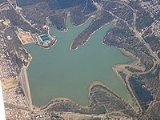
Happy Valley Reservoir
Encyclopedia
Constructed when the total population of Adelaide
numbered 315,200 (1893 census) the Happy Valley Reservoir now supplies over a half a million people, from Adelaide's southern extent to the city-centre
.
1.8 million it was the third reservoir constructed in South Australia
as a supplement to the Thorndon Park Reservoir ( built 1860) and the Hope Valley Reservoir
(built 1872).
The original Happy Valley township, school and cemetery were completely flooded by the new reservoir requiring their relocation. The township was moved to the east while the cemetery, which is still in use today, was moved to the west and relocated alongside the base of the dam wall. The school, originally located on Candy road, was relocated south to two acres of land on Red Hill Road (later renamed Education road) which was donated by local farmer Harry Mason. While some students attended O'Halloran Hill or Clarendon schools for the 18 months that the Happy Valley school was closed, some did not attend any school until it was re-opened on 26 September 1898. The school closed in December 1979 and re-opened on a new site on the other side of the road directly opposite.
The reservoir acts as a 'holding pond' for water directed to it from the Clarendon Weir
via a five km long underground tunnel. The 1.8 m diameter tunnel was bored simultaneously from both ends and when meeting had a deviation of 25 mm. Its deepest point underground is 122 m where it passes through a hill. On 7 August 1896 the tunnel's inlet valve was opened by the Governor of South Australia, Sir Thomas Fowell Buxton and the reservoir began filling.
, the reservoir is now largely enveloped by the city's southern suburbs, of which the relocated Happy Valley
village is now one. Although the reservoir is relatively small in capacity; holding only 11,500 megalitres and is dwarfed by Mount Bold Reservoir
which is at least four times larger, it is the site of the biggest water treatment plant in Adelaide and is responsible for providing more than 40% of the city's water.
With public access prohibited, the natural bush
of the reservoir's enclosed catchments are home to kangaroo
s, echidna
s and koala
s. Several areas have also been planted with managed pine plantation
s to reduce soil erosion and provide an income from harvesting. As a result of the plantations being located within what are now inner city suburbs they have become almost iconic. In the early 2000s, plans to harvest the mature pines were blocked following public protests over the visual impact the clearance and replanting would have on the surrounding suburbs.
Water from the dam was originally supplied to Adelaide through a tunnel under Black Road. In the early 1960s, the original intake tunnel from the Clarendon Weir was increased in size to allow access by maintenance vehicles, and a second outlet tunnel was constructed under South Road. In 1986 this new tunnel became the sole outlet for the reservoir when the original outlet was abandoned. At the same time the Thorndon Park Reservoir was decommissioned and reestablished as a recreational park.
With the lowering of the water level during renovations exposing the original Happy Valley township for the first time, archaeologists took the opportunity to excavate the site. Despite the township being entirely intact and undamaged when flooded in 1896, very little was found apart from scattered bricks and the foundations of several buildings of which only the Post Office was identified.
Adelaide
Adelaide is the capital city of South Australia and the fifth-largest city in Australia. Adelaide has an estimated population of more than 1.2 million...
numbered 315,200 (1893 census) the Happy Valley Reservoir now supplies over a half a million people, from Adelaide's southern extent to the city-centre
City of Adelaide
The City of Adelaide is a local government area in the metropolitan area of Adelaide, South Australia. It covers the original Adelaide city centre settlement, , North Adelaide, and the Adelaide Park Lands which surround North Adelaide and the city centre.Established in 1840, the organisation now...
.
Construction
Built between 1892 and 1897 at a cost of A$Australian dollar
The Australian dollar is the currency of the Commonwealth of Australia, including Christmas Island, Cocos Islands, and Norfolk Island, as well as the independent Pacific Island states of Kiribati, Nauru and Tuvalu...
1.8 million it was the third reservoir constructed in South Australia
South Australia
South Australia is a state of Australia in the southern central part of the country. It covers some of the most arid parts of the continent; with a total land area of , it is the fourth largest of Australia's six states and two territories.South Australia shares borders with all of the mainland...
as a supplement to the Thorndon Park Reservoir ( built 1860) and the Hope Valley Reservoir
Hope Valley Reservoir
The Hope Valley Reservoir is a 2840 megalitre service reservoir in Hope Valley, South Australia, a suburb of Adelaide, South Australia.When completed in 1873 it was the second reservoir constructed in Adelaide; it is the oldest still in use in South Australia. It covers and is retained behind a ...
(built 1872).
The original Happy Valley township, school and cemetery were completely flooded by the new reservoir requiring their relocation. The township was moved to the east while the cemetery, which is still in use today, was moved to the west and relocated alongside the base of the dam wall. The school, originally located on Candy road, was relocated south to two acres of land on Red Hill Road (later renamed Education road) which was donated by local farmer Harry Mason. While some students attended O'Halloran Hill or Clarendon schools for the 18 months that the Happy Valley school was closed, some did not attend any school until it was re-opened on 26 September 1898. The school closed in December 1979 and re-opened on a new site on the other side of the road directly opposite.
The reservoir acts as a 'holding pond' for water directed to it from the Clarendon Weir
Clarendon Weir
The Clarendon Weir is a small weir on the Onkaparinga River, near Adelaide in South Australia. Built in 1894–96 as part of the early Onkaparinga Water Scheme, the weir was designed to pool water from the Mount Bold Reservoir, on the Onkaparinga, which is often boosted with water from the River Murray...
via a five km long underground tunnel. The 1.8 m diameter tunnel was bored simultaneously from both ends and when meeting had a deviation of 25 mm. Its deepest point underground is 122 m where it passes through a hill. On 7 August 1896 the tunnel's inlet valve was opened by the Governor of South Australia, Sir Thomas Fowell Buxton and the reservoir began filling.
Continuing use
Initially 15 kilometres from AdelaideAdelaide
Adelaide is the capital city of South Australia and the fifth-largest city in Australia. Adelaide has an estimated population of more than 1.2 million...
, the reservoir is now largely enveloped by the city's southern suburbs, of which the relocated Happy Valley
Happy Valley, South Australia
Happy Valley is a metropolitan suburb of Adelaide, South Australia. It is located 20 km south of the Central Business District of Adelaide.Within the suburb is the Happy Valley Reservoir accompanied by South Australia's largest water treatment plant, responsible for supplying water to much of the...
village is now one. Although the reservoir is relatively small in capacity; holding only 11,500 megalitres and is dwarfed by Mount Bold Reservoir
Mount Bold Reservoir
-2007 fire:A bushfire ravaged the Mount Bold Valley area, which includes the properties between Kangarilla and Echunga, during the second week of January 2007. The fire destroyed two houses, gutted over ten sheds and killed livestock and horses. Two people were injured and fencing was damaged. The...
which is at least four times larger, it is the site of the biggest water treatment plant in Adelaide and is responsible for providing more than 40% of the city's water.
With public access prohibited, the natural bush
The Bush
"The bush" is a term used for rural, undeveloped land or country areas in certain countries.-Australia:The term is iconic in Australia. In reference to the landscape, "bush" describes a wooded area, intermediate between a shrubland and a forest, generally of dry and nitrogen-poor soil, mostly...
of the reservoir's enclosed catchments are home to kangaroo
Kangaroo
A kangaroo is a marsupial from the family Macropodidae . In common use the term is used to describe the largest species from this family, especially those of the genus Macropus, Red Kangaroo, Antilopine Kangaroo, Eastern Grey Kangaroo and Western Grey Kangaroo. Kangaroos are endemic to the country...
s, echidna
Echidna
Echidnas , also known as spiny anteaters, belong to the family Tachyglossidae in the monotreme order of egg-laying mammals. There are four extant species, which, together with the platypus, are the only surviving members of that order and are the only extant mammals that lay eggs...
s and koala
Koala
The koala is an arboreal herbivorous marsupial native to Australia, and the only extant representative of the family Phascolarctidae....
s. Several areas have also been planted with managed pine plantation
Plantation
A plantation is a long artificially established forest, farm or estate, where crops are grown for sale, often in distant markets rather than for local on-site consumption...
s to reduce soil erosion and provide an income from harvesting. As a result of the plantations being located within what are now inner city suburbs they have become almost iconic. In the early 2000s, plans to harvest the mature pines were blocked following public protests over the visual impact the clearance and replanting would have on the surrounding suburbs.
Water from the dam was originally supplied to Adelaide through a tunnel under Black Road. In the early 1960s, the original intake tunnel from the Clarendon Weir was increased in size to allow access by maintenance vehicles, and a second outlet tunnel was constructed under South Road. In 1986 this new tunnel became the sole outlet for the reservoir when the original outlet was abandoned. At the same time the Thorndon Park Reservoir was decommissioned and reestablished as a recreational park.
Upgrade
Between 2002 and 2004, the Reservoir underwent a major renovation as part of A$22 million rehabilitation project aimed at enhancing the Reservoir to meet guidelines of best practice for dam management at both international and national levels. The reservoir's earth wall was particularly susceptible to piping failure (a small leak, called a pipe, gets larger until the dam collapses) and the renovations lowered the risk of dam wall failure from 1 in 1,200 to an estimated 1 in 100,000. Part of this project included an upgrade of the dam wall designed to also increase flood storage capacity by 165% and reduce risk of damage in the event of an earthquake.With the lowering of the water level during renovations exposing the original Happy Valley township for the first time, archaeologists took the opportunity to excavate the site. Despite the township being entirely intact and undamaged when flooded in 1896, very little was found apart from scattered bricks and the foundations of several buildings of which only the Post Office was identified.
- Capacity: 11.5 Gigalitres
- Length of wall: 1,155 m
- Height of wall: 23.6 m
- Type of wall: Earth with clay core
- Area of water spread: 1.88 km²