
Haltwhistle
Encyclopedia
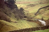
Haltwhistle is a small town and civil parish in Northumberland
, England
, situated 10 miles (16.1 km) east of Brampton
, near Hadrian's Wall
, and the villages of Plenmeller
, Rowfoot
and Melkridge
. It has a population
of 3,811.
Well constructed, stone-built houses are still a feature of central Haltwhistle, and though there are none outstanding architecturally the general appearance of the groups is harmonious. The houses were built of local stone, but with the railway, other materials could be brought in. It is one of two settlements in Great Britain which claim to be the exact geographic centre of the island, along with Dunsop Bridge
in Lancashire
, located 71 miles (114.3 km) to the south.
The first part is probably derived from Old English hēafod, here 'hill-top', in general, 'head', 'headland', 'summit', 'upper end' or 'source of a stream'. If so, it describes the hill-top on which Holy Cross Church and the oldest part of Haltwhistle was built, enclosed on the north-east and west by Haltwhistle Brook and on the south by the South Tyne. Rowland suggests Hal from 'hill'
An suggestion is French
haut-, meaning 'high', since the settlement already existed long before the Norman Conquest.
times, as it is one of the closest approaches of the River South Tyne in its upland reaches to Hadrian's Wall
. The old Roman road
or Stanegate
passes just two miles to the north of the town.
The development of the town was based on its position on the main Newcastle
to Carlisle road and on the Newcastle and Carlisle Railway
line.
The expansion of Haltwhistle in the 18th and 19th centuries was due to coal mining
in the area and to a lesser extent the use of Haltwhistle as a loading point for metal ores coming from the mines on Alston Moor
. In 1836 while some workmen were quarrying stone for the Directors of the Newcastle and Carlisle Railway, on the top of Boreum, a high hill in the township of Thorngrafton and Parish of Haltwhistle, one of them found a copper vessel containing 63 coins, 3 of them gold and 60 copper. The gold coins were, one of Claudius Caesar, reverse Nero Claudius Drusus Germanicus
; one of Nero
and one of Vespasian
.
More recently, paint manufacture became a major commercial force in the town, but has now stopped major production. Current local employers include factories making plastic bottles and de-icing products.
In the 21st century, the tourist industry
dominates the economy with Hadrian's Wall and walking and rambling counting among the principal interests of tourists.
and was up unitil April 2009 part of Tynedale district
. It maintains an active Town Council which has succeeded in making a number of local improvements including the establishment in 1975 of a heated outdoor swimming pool
complex which is very popular during the summer months. It is believed that Haltwhistle may be one of the smallest towns to have made such a provision in Great Britain.
is in the parliamentary constituency of Hexham
.
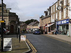 Haltwhistle was a market town for the exchange of local goods. In the 18th century two Quakers set up a baize manufactury and there was a weaving establishment. On the Haltwhistle Burn were fulling mills, dyeing and spinning mills. A walk along this stream to the Roman Wall, shows that it must have been a hive of industry with quarries, coal mining and lime burning kilns. The Directory of 1822 (Pigot) gives a whole range of craftsmen, shopkeepers and traders—60 in number, including makers of clogs. The weekly market was held on Thursdays and there were fairs on May 14 and November 22 for cattle and sheep.
to the north of the town is used as a major selling point for the town. The section of the wall closest to Haltwhistle is among the most spectacular and complete, with the wall striding eastwards from the lake at Crag Lough
along the spine of the Whin Sill
. The remains of Haltwhistle Castle and the series of Bastles
, and Haltwhistle Tower. Haltwhistle also claims to be at the geographic centre of Britain - equidistant from the sea as measured along the principal points of the compass. A hotel in the centre of Haltwhistle is named the Centre of Britain Hotel in recognition of this claim. The claim is rather tenuous as it requires that the northern extremity is taken to be Orkney rather than Shetland. Depending on how the centre of the island is calculated however the centre can be said to be Dunsop Bridge
in Lancashire
. See Centre points of the United Kingdom
.
There are many historic properties nearby, including Featherstone Castle
, Blenkinsop Castle
, Unthank Hall
, Bellister Castle
and Thirlwall Castle
.
Haltwhistle Viaduct lies to the south of the railway station and was the first major feature on the Alston Line
to Alston
, Cumbria
.
 The town is served by Haltwhistle railway station
on the Newcastle and Carlisle Railway
, also known as the Tyne Valley Line. The line was opened in 1838, and links the city of Newcastle upon Tyne
in Tyne and Wear
with Carlisle
in Cumbria
. The line follows the course of the River Tyne
through Northumberland
.
Passenger services on the Tyne Valley Line are operated by Northern Rail
and First ScotRail
. The line is also heavily used for freight. The railway station is on the south side of the town close by the River South Tyne
.
Until 1976 the railway station was also the northern terminus of the branch line
to Alston
, in Cumbria
, the line was thirteen miles in length. Part of the southern end of the Haltwhistle to Alston line has been reopened as a two foot narrow gauge railway, known as the South Tynedale Railway
, between Alston and Kirkhaugh
.
Road
The A69
trunk road which links Carlisle and Newcastle upon Tyne
formerly passed south of the town centre and through the western part of the town until a full bypass was opened in 1997.
(seats for the clergy). There are a number of medieval grave covers to Blenkinsopps and Thirlwells. The nave measures 63 by and has side aisles above which are clerestory
windows. It has four bays with round columns and pointed arches, looking very spacious inside. The font
, dated 1676, has some curious crude carvings on it, and there is another large circular bowl on a shaft, which is probably an earlier font. At the west end it has long lancet windows and a bell-cote, again typical of the North country.
Northumberland
Northumberland is the northernmost ceremonial county and a unitary district in North East England. For Eurostat purposes Northumberland is a NUTS 3 region and is one of three boroughs or unitary districts that comprise the "Northumberland and Tyne and Wear" NUTS 2 region...
, England
England
England is a country that is part of the United Kingdom. It shares land borders with Scotland to the north and Wales to the west; the Irish Sea is to the north west, the Celtic Sea to the south west, with the North Sea to the east and the English Channel to the south separating it from continental...
, situated 10 miles (16.1 km) east of Brampton
Brampton, Carlisle, Cumbria
Brampton is a small market town and civil parish within the City of Carlisle district of Cumbria, England about 9 miles east of Carlisle and 2 miles south of Hadrian's Wall. It is situated off the A69 road which bypasses it...
, near Hadrian's Wall
Hadrian's Wall
Hadrian's Wall was a defensive fortification in Roman Britain. Begun in AD 122, during the rule of emperor Hadrian, it was the first of two fortifications built across Great Britain, the second being the Antonine Wall, lesser known of the two because its physical remains are less evident today.The...
, and the villages of Plenmeller
Plenmeller
Plenmeller is a village in Northumberland, England about a mile southeast of Haltwhistle.- Governance : is in the parliamentary constituency of Hexham.- Landmarks :...
, Rowfoot
Rowfoot
Rowfoot is a hamlet in Northumberland, England at .-External links:...
and Melkridge
Melkridge
Melkridge is a village and civil parish in Northumberland, England on the river South Tyne. The village of Melkridge is in the south of the parish, and is about two miles east of Haltwhistle along the A69 road...
. It has a population
Population
A population is all the organisms that both belong to the same group or species and live in the same geographical area. The area that is used to define a sexual population is such that inter-breeding is possible between any pair within the area and more probable than cross-breeding with individuals...
of 3,811.
Well constructed, stone-built houses are still a feature of central Haltwhistle, and though there are none outstanding architecturally the general appearance of the groups is harmonious. The houses were built of local stone, but with the railway, other materials could be brought in. It is one of two settlements in Great Britain which claim to be the exact geographic centre of the island, along with Dunsop Bridge
Dunsop Bridge
Dunsop Bridge is a village within the Ribble Valley borough of Lancashire, England, situated north-west of Clitheroe, south-east of Lancaster and east of Skipton. It is in the civil parish of Bowland Forest High....
in Lancashire
Lancashire
Lancashire is a non-metropolitan county of historic origin in the North West of England. It takes its name from the city of Lancaster, and is sometimes known as the County of Lancaster. Although Lancaster is still considered to be the county town, Lancashire County Council is based in Preston...
, located 71 miles (114.3 km) to the south.
The name
The name of Haltwhistle has nothing to do with a railway stop. Early forms of the name are Hautwesel (1240), Hautwysel (1254), Hawtewysill (1279), Haltwesell (Speede 1610). The second part -twistle relates to two streams or rivers. It derives from two Old English words twicce or twise, 'twice', 'division into two' and wella, 'stream, brook'. The second word is reduced in the compound word to ull, making twicculla, twisella. All but one of the examples in place names represent a high tongue of land between two streams where they join.The first part is probably derived from Old English hēafod, here 'hill-top', in general, 'head', 'headland', 'summit', 'upper end' or 'source of a stream'. If so, it describes the hill-top on which Holy Cross Church and the oldest part of Haltwhistle was built, enclosed on the north-east and west by Haltwhistle Brook and on the south by the South Tyne. Rowland suggests Hal from 'hill'
An suggestion is French
French language
French is a Romance language spoken as a first language in France, the Romandy region in Switzerland, Wallonia and Brussels in Belgium, Monaco, the regions of Quebec and Acadia in Canada, and by various communities elsewhere. Second-language speakers of French are distributed throughout many parts...
haut-, meaning 'high', since the settlement already existed long before the Norman Conquest.
History
Haltwhistle was probably in existence in RomanRoman Britain
Roman Britain was the part of the island of Great Britain controlled by the Roman Empire from AD 43 until ca. AD 410.The Romans referred to the imperial province as Britannia, which eventually comprised all of the island of Great Britain south of the fluid frontier with Caledonia...
times, as it is one of the closest approaches of the River South Tyne in its upland reaches to Hadrian's Wall
Hadrian's Wall
Hadrian's Wall was a defensive fortification in Roman Britain. Begun in AD 122, during the rule of emperor Hadrian, it was the first of two fortifications built across Great Britain, the second being the Antonine Wall, lesser known of the two because its physical remains are less evident today.The...
. The old Roman road
Roman road
The Roman roads were a vital part of the development of the Roman state, from about 500 BC through the expansion during the Roman Republic and the Roman Empire. Roman roads enabled the Romans to move armies and trade goods and to communicate. The Roman road system spanned more than 400,000 km...
or Stanegate
Stanegate
The Stanegate, or "stone road" , was an important Roman road built in what is now northern England. It linked two forts that guarded important river crossings; Corstopitum in the east, situated on Dere Street, and Luguvalium in the west...
passes just two miles to the north of the town.
The development of the town was based on its position on the main Newcastle
Newcastle upon Tyne
Newcastle upon Tyne is a city and metropolitan borough of Tyne and Wear, in North East England. Historically a part of Northumberland, it is situated on the north bank of the River Tyne...
to Carlisle road and on the Newcastle and Carlisle Railway
Newcastle and Carlisle Railway
The Newcastle and Carlisle Railway, occasionally referred to as the Tyne Valley Line, is a railway line in northern England. The line was built in the 1830s, and links the city of Newcastle upon Tyne in Tyne and Wear with in Cumbria. Formal opening took place on 18 June 1838.The line follows the...
line.
The expansion of Haltwhistle in the 18th and 19th centuries was due to coal mining
Coal mining
The goal of coal mining is to obtain coal from the ground. Coal is valued for its energy content, and since the 1880s has been widely used to generate electricity. Steel and cement industries use coal as a fuel for extraction of iron from iron ore and for cement production. In the United States,...
in the area and to a lesser extent the use of Haltwhistle as a loading point for metal ores coming from the mines on Alston Moor
Alston Moor
Alston Moor is an area of moorland and civil parish in Cumbria, England, based around the small town of Alston. The parish had a population of 2,156 at the 2001 census. As well as the town of Alston, the parish includes the villages of Garrigill and Nenthead, along with the hamlets of Nenthall,...
. In 1836 while some workmen were quarrying stone for the Directors of the Newcastle and Carlisle Railway, on the top of Boreum, a high hill in the township of Thorngrafton and Parish of Haltwhistle, one of them found a copper vessel containing 63 coins, 3 of them gold and 60 copper. The gold coins were, one of Claudius Caesar, reverse Nero Claudius Drusus Germanicus
Nero Claudius Drusus
Nero Claudius Drusus Germanicus , born Decimus Claudius Drusus also called Drusus, Drusus I, Nero Drusus, or Drusus the Elder was a Roman politician and military commander. He was a fully patrician Claudian on his father's side but his maternal grandmother was from a plebeian family...
; one of Nero
Nero
Nero , was Roman Emperor from 54 to 68, and the last in the Julio-Claudian dynasty. Nero was adopted by his great-uncle Claudius to become his heir and successor, and succeeded to the throne in 54 following Claudius' death....
and one of Vespasian
Vespasian
Vespasian , was Roman Emperor from 69 AD to 79 AD. Vespasian was the founder of the Flavian dynasty, which ruled the Empire for a quarter century. Vespasian was descended from a family of equestrians, who rose into the senatorial rank under the Emperors of the Julio-Claudian dynasty...
.
More recently, paint manufacture became a major commercial force in the town, but has now stopped major production. Current local employers include factories making plastic bottles and de-icing products.
In the 21st century, the tourist industry
Tourism
Tourism is travel for recreational, leisure or business purposes. The World Tourism Organization defines tourists as people "traveling to and staying in places outside their usual environment for not more than one consecutive year for leisure, business and other purposes".Tourism has become a...
dominates the economy with Hadrian's Wall and walking and rambling counting among the principal interests of tourists.
Governance
Haltwhistle lies within the now unitary Northumberland County CouncilNorthumberland
Northumberland is the northernmost ceremonial county and a unitary district in North East England. For Eurostat purposes Northumberland is a NUTS 3 region and is one of three boroughs or unitary districts that comprise the "Northumberland and Tyne and Wear" NUTS 2 region...
and was up unitil April 2009 part of Tynedale district
Tynedale
Tynedale was a local government district in south-west Northumberland, England. It had a resident population of 58,808 according to the 2001 Census, and was named after the River Tyne . Its main towns were Hexham, Haltwhistle and Prudhoe...
. It maintains an active Town Council which has succeeded in making a number of local improvements including the establishment in 1975 of a heated outdoor swimming pool
Lido
The Lido is an 11 km long sandbar located in Venice, northern Italy, home to about 20,000 residents. The Venice Film Festival takes place at the Lido every September.-Geography:...
complex which is very popular during the summer months. It is believed that Haltwhistle may be one of the smallest towns to have made such a provision in Great Britain.
is in the parliamentary constituency of Hexham
Hexham (UK Parliament constituency)
- Elections in the 2000s :- Elections in the 1990s :- Elections in the 1980s :- Elections in the 1970s :-Notes and references:...
.
Economy
Landmarks
Hadrian's WallHadrian's Wall
Hadrian's Wall was a defensive fortification in Roman Britain. Begun in AD 122, during the rule of emperor Hadrian, it was the first of two fortifications built across Great Britain, the second being the Antonine Wall, lesser known of the two because its physical remains are less evident today.The...
to the north of the town is used as a major selling point for the town. The section of the wall closest to Haltwhistle is among the most spectacular and complete, with the wall striding eastwards from the lake at Crag Lough
Crag Lough
Crag Lough is an inland lake at the southern edge of Northumberland National Park, north of Bardon Mill, and north of the B6318 Military Road road in Northumberland, northern England. At this point Hadrian's Wall is at the top of a line of crags with Crag Lough at the foot of the crags....
along the spine of the Whin Sill
Whin Sill
The Whin Sill or Great Whin Sill is a tabular layer of the igneous rock dolerite in County Durham and Northumberland in the northeast of England. It lies partly in the North Pennines Area of Outstanding Natural Beauty and partly in Northumberland National Park and stretches from Teesdale northwards...
. The remains of Haltwhistle Castle and the series of Bastles
Bastle house
Bastle houses are a type of construction found along the Anglo-Scottish border, in the areas formerly plagued by border Reivers. They are farmhouses, characterised by elaborate security measures against raids...
, and Haltwhistle Tower. Haltwhistle also claims to be at the geographic centre of Britain - equidistant from the sea as measured along the principal points of the compass. A hotel in the centre of Haltwhistle is named the Centre of Britain Hotel in recognition of this claim. The claim is rather tenuous as it requires that the northern extremity is taken to be Orkney rather than Shetland. Depending on how the centre of the island is calculated however the centre can be said to be Dunsop Bridge
Dunsop Bridge
Dunsop Bridge is a village within the Ribble Valley borough of Lancashire, England, situated north-west of Clitheroe, south-east of Lancaster and east of Skipton. It is in the civil parish of Bowland Forest High....
in Lancashire
Lancashire
Lancashire is a non-metropolitan county of historic origin in the North West of England. It takes its name from the city of Lancaster, and is sometimes known as the County of Lancaster. Although Lancaster is still considered to be the county town, Lancashire County Council is based in Preston...
. See Centre points of the United Kingdom
Centre points of the United Kingdom
There has long been debate over the exact location of the geographical centre of the United Kingdom, and its constituent countries, due to the complexity and method of the calculation, such as whether to include offshore islands, and the fact that erosion will cause the position to change over time...
.
There are many historic properties nearby, including Featherstone Castle
Featherstone Castle
Featherstone Castle, a Grade I listed building, is a large Gothic style country mansion situated on the bank of the River South Tyne about southwest of the town of Haltwhistle in Northumberland, England....
, Blenkinsop Castle
Blenkinsop Castle
Blenkinsopp Castle is a fire-damaged, partly demolished 19th-century country mansion incorporating the ruinous remains of a 14th-century tower house located above the Tipalt Burn approximately one mile from Greenhead, Northumberland, England...
, Unthank Hall
Unthank Hall
Unthank Hall is a Grade II listed mansion house, situated on the southern bank of the River South Tyne east of Plenmeller, near Haltwhistle, Northumberland....
, Bellister Castle
Bellister Castle
Bellister Castle is a National Trust owned castellated 19th century mansion house attached to the ruinous remains of a 14th century tower house, situated near Haltwhistle, Northumberland, England. It is a Scheduled Ancient Monument and a Grade I listed building.The property stands on a mound which...
and Thirlwall Castle
Thirlwall Castle
Thirlwall Castle is a 12th-century castle in Northumberland, England, on the bank of the River Tipalt close to the village of Greenhead and approximately west of Hexham. It was built in the 12th century, and later strengthened using stones from nearby Hadrian's Wall, but began to fall into...
.
Haltwhistle Viaduct lies to the south of the railway station and was the first major feature on the Alston Line
Alston Line
The Alston Line was a standard gauge branch line railway that operated in the counties of Northumberland and Cumbria in England. Starting at its junction with the Newcastle and Carlisle Railway line at Haltwhistle, the line ran to the town of Alston...
to Alston
Alston, Cumbria
Alston is a small town in Cumbria, England on the River South Tyne. It is one of the highest elevation towns in the country, at about 1,000 feet above sea level.-Geography:...
, Cumbria
Cumbria
Cumbria , is a non-metropolitan county in North West England. The county and Cumbria County Council, its local authority, came into existence in 1974 after the passage of the Local Government Act 1972. Cumbria's largest settlement and county town is Carlisle. It consists of six districts, and in...
.
Transport
RailwayHaltwhistle railway station
Haltwhistle railway station is a railway station which serves the town of Haltwhistle in Northumberland, England. It is located on the Tyne Valley Line east of Carlisle...
on the Newcastle and Carlisle Railway
Newcastle and Carlisle Railway
The Newcastle and Carlisle Railway, occasionally referred to as the Tyne Valley Line, is a railway line in northern England. The line was built in the 1830s, and links the city of Newcastle upon Tyne in Tyne and Wear with in Cumbria. Formal opening took place on 18 June 1838.The line follows the...
, also known as the Tyne Valley Line. The line was opened in 1838, and links the city of Newcastle upon Tyne
Newcastle upon Tyne
Newcastle upon Tyne is a city and metropolitan borough of Tyne and Wear, in North East England. Historically a part of Northumberland, it is situated on the north bank of the River Tyne...
in Tyne and Wear
Tyne and Wear
Tyne and Wear is a metropolitan county in north east England around the mouths of the Rivers Tyne and Wear. It came into existence as a metropolitan county in 1974 after the passage of the Local Government Act 1972...
with Carlisle
Carlisle railway station
Carlisle railway station, also known as Carlisle Citadel station, is a railway station whichserves the Cumbrian City of Carlisle, England, and is a major station on the West Coast Main Line, lying south of Glasgow Central, and north of London Euston...
in Cumbria
Cumbria
Cumbria , is a non-metropolitan county in North West England. The county and Cumbria County Council, its local authority, came into existence in 1974 after the passage of the Local Government Act 1972. Cumbria's largest settlement and county town is Carlisle. It consists of six districts, and in...
. The line follows the course of the River Tyne
River Tyne
The River Tyne is a river in North East England in Great Britain. It is formed by the confluence of two rivers: the North Tyne and the South Tyne. These two rivers converge at Warden Rock near Hexham in Northumberland at a place dubbed 'The Meeting of the Waters'.The North Tyne rises on the...
through Northumberland
Northumberland
Northumberland is the northernmost ceremonial county and a unitary district in North East England. For Eurostat purposes Northumberland is a NUTS 3 region and is one of three boroughs or unitary districts that comprise the "Northumberland and Tyne and Wear" NUTS 2 region...
.
Passenger services on the Tyne Valley Line are operated by Northern Rail
Northern Rail
Northern Rail is a British train operating company that has operated local passenger services in Northern England since 2004. Northern Rail's owner, Serco-Abellio, is a consortium formed of Abellio and Serco, an international operator of public transport systems...
and First ScotRail
First ScotRail
ScotRail Railways Ltd. is the FirstGroup-owned train operating company running domestic passenger trains within Scotland, northern England and the cross-border Caledonian Sleeper service to London using the brand ScotRail which is the property of the Scottish Government...
. The line is also heavily used for freight. The railway station is on the south side of the town close by the River South Tyne
River Tyne
The River Tyne is a river in North East England in Great Britain. It is formed by the confluence of two rivers: the North Tyne and the South Tyne. These two rivers converge at Warden Rock near Hexham in Northumberland at a place dubbed 'The Meeting of the Waters'.The North Tyne rises on the...
.
Until 1976 the railway station was also the northern terminus of the branch line
Alston Line
The Alston Line was a standard gauge branch line railway that operated in the counties of Northumberland and Cumbria in England. Starting at its junction with the Newcastle and Carlisle Railway line at Haltwhistle, the line ran to the town of Alston...
to Alston
Alston, Cumbria
Alston is a small town in Cumbria, England on the River South Tyne. It is one of the highest elevation towns in the country, at about 1,000 feet above sea level.-Geography:...
, in Cumbria
Cumbria
Cumbria , is a non-metropolitan county in North West England. The county and Cumbria County Council, its local authority, came into existence in 1974 after the passage of the Local Government Act 1972. Cumbria's largest settlement and county town is Carlisle. It consists of six districts, and in...
, the line was thirteen miles in length. Part of the southern end of the Haltwhistle to Alston line has been reopened as a two foot narrow gauge railway, known as the South Tynedale Railway
South Tynedale Railway
The South Tynedale Railway is a heritage railway in England and is England's highest narrow gauge railway. The route runs from Alston in Cumbria to Kirkhaugh in Northumberland via the South Tyne Viaduct, the Gilderdale Viaduct and the Whitley Viaduct...
, between Alston and Kirkhaugh
Kirkhaugh
Kirkhaugh is a village in Northumberland, England close to the A689 road north of Alston, Cumbria.- Governance :Kirkhaugh is in the parliamentary constituency of Hexham.- Transport :Railways...
.
Road
The A69
A69 road
The A69 is a major road in northern England, running east-west across the Pennines, through the counties of Tyne and Wear, Northumberland and Cumbria. Originally the road started in Blaydon, but since the creation of the A1 Western Bypass around Newcastle upon Tyne, it now starts at Denton Burn a...
trunk road which links Carlisle and Newcastle upon Tyne
Newcastle upon Tyne
Newcastle upon Tyne is a city and metropolitan borough of Tyne and Wear, in North East England. Historically a part of Northumberland, it is situated on the north bank of the River Tyne...
formerly passed south of the town centre and through the western part of the town until a full bypass was opened in 1997.
Religious sites
The Church of the Holy Cross is situated below the Market Place with views over the river and the valley. It is a good example of a North Country church, impressive considering the time when it was built in the thirteenth century. The chancel measures 46 by, with lancet windows — combined three lights in the east end and four single lights on each side, the walls being supported by buttresses. Inside is a piscine (for washing) and three sediliaSedilia
Sedilia , in ecclesiastical architecture, is the term used to describe stone seats, usually to be found on the south side of an altar, often in the chancel, for the use of the officiating priests...
(seats for the clergy). There are a number of medieval grave covers to Blenkinsopps and Thirlwells. The nave measures 63 by and has side aisles above which are clerestory
Clerestory
Clerestory is an architectural term that historically denoted an upper level of a Roman basilica or of the nave of a Romanesque or Gothic church, the walls of which rise above the rooflines of the lower aisles and are pierced with windows. In modern usage, clerestory refers to any high windows...
windows. It has four bays with round columns and pointed arches, looking very spacious inside. The font
Baptismal font
A baptismal font is an article of church furniture or a fixture used for the baptism of children and adults.-Aspersion and affusion fonts:...
, dated 1676, has some curious crude carvings on it, and there is another large circular bowl on a shaft, which is probably an earlier font. At the west end it has long lancet windows and a bell-cote, again typical of the North country.
See also
- Bellister CastleBellister CastleBellister Castle is a National Trust owned castellated 19th century mansion house attached to the ruinous remains of a 14th century tower house, situated near Haltwhistle, Northumberland, England. It is a Scheduled Ancient Monument and a Grade I listed building.The property stands on a mound which...
- Blenkinsop CastleBlenkinsop CastleBlenkinsopp Castle is a fire-damaged, partly demolished 19th-century country mansion incorporating the ruinous remains of a 14th-century tower house located above the Tipalt Burn approximately one mile from Greenhead, Northumberland, England...
- Featherstone CastleFeatherstone CastleFeatherstone Castle, a Grade I listed building, is a large Gothic style country mansion situated on the bank of the River South Tyne about southwest of the town of Haltwhistle in Northumberland, England....
- Haltwhistle Viaduct
- Thirlwall CastleThirlwall CastleThirlwall Castle is a 12th-century castle in Northumberland, England, on the bank of the River Tipalt close to the village of Greenhead and approximately west of Hexham. It was built in the 12th century, and later strengthened using stones from nearby Hadrian's Wall, but began to fall into...
. - Unthank HallUnthank HallUnthank Hall is a Grade II listed mansion house, situated on the southern bank of the River South Tyne east of Plenmeller, near Haltwhistle, Northumberland....