
Gyêgu Tibetan Autonomous Prefecture
Encyclopedia
Yulshul Tibetan Autonomous Prefecture , commonly known as Yushu , is an autonomous prefecture of southwestern Qinghai
province, Western China
. Largely inhabited by Tibetans, the prefecture has an area of 188794 square kilometres (72,893.8 sq mi) and its seat is located in the town of Gyêgu in Yushu County, which is the place of the old Tibetan trade mart of Jyekundo. The official source of the Yellow River
lies within the prefecture. Historically, the area belongs to the cultural realm of Kham
in eastern Tibet
.
On 14 April 2010, an earthquake
struck the prefecture, registering a magnitude of 6.9 (USGS, EMSC
) or 7.1 (Xinhua). It originated in the Yushu Tibetan Autonomous Prefecture, Qinghai
, at local time.
), which is an exclave of the Haixi Mongol and Tibetan Autonomous Prefecture
. Almost all of the prefecture is located in the uppermost part of the basins of three of Asia's great rivers - the Yellow River
, the Yangtze, and the Mekong
, although in the remote areas of the far west of the prefecture (the Hoh Xil plateau), and along its northern borders, there are some endorheic
basins as well. A significant portion of the prefecture's territory is incorporated into the Sanjiangyuan National Nature Reserve
, intended to protect the headwaters of the three great rivers.
Most of the prefecture's population lives in its southeastern part: primarily in the valley of the upper Yangtze (whose section within the prefecture is known in Chinese as the Tongtian River
, in Tibetan as Drichu ), and some also in the valley of the Mekong (the Dzachu (扎曲) River). The highlands away from these two rivers, as well as the western part of the prefecture, have very little population.
, the prefecture ranges from the alpine variation of the subarctic climate
(Köppen Dwc), to a full alpine climate
(Köppen EH), to a semi-arid climate (Köppen BSk). Most of the annual precipitation occurs from June to September, when on average, a majority of the days each month has some rainfall. The annual mean temperature in Yushu County, at an elevation of 3690 metres (12,106.3 ft), is 3.22 °C (37.8 °F) and in Qumarlêb, in the northeast of the prefecture at 4190 m (13,746.7 ft) elevation, −2.13 °C. Sunshine is generous, ranging from around 2500 hours in the prefecture seat to 2780 hours in Qumarlêb.
This statistics only includes the registered population, not the floating population which is estimated at about 50-60,000 for the entire prefecture.
 The eastern part of the prefecture, where most of its population lives, is served by the China National Highway 214
and the recently constructed (opened 2009) Yushu Batang Airport
.
The far western part part of the prefecture, which is hundreds of kilometers away from the prefecture's eastern "core", and has very little population, is crossed by China National Highway 109
and the Qinghai-Tibet Railway.
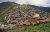
Yushu prefecture is rich in Buddhist monasteries. Being a constituent of the former Nangchen kingdom, the area was, for most of the time, not under domination by the Dalai Lama
’s Gelugpa order in Lhasa. The different balance of power in this part of Kham enabled the older Tibetan Buddhist orders to prevail in Yushu.
Of the 195 pre-1958 lamaseries only 23 belonged to the Gelugpa.
An overwhelming majority of more than 100 monasteries followed and still follow the teachings of the various Kagyupa schools, with some of their sub-sects only found in this part of Tibet. The Sakyapa were and are also strong in Yushu, with many of their 32 monasteries being among the most significant in Kham. The Nyingmapa’s monastic institutions amount to about the same number, while the Bönpo are only met with in one lamasery they share with the Nyingmapa.
Prior to collectivization in 1958, the entire monastic population of present-day Yushu TAP amounted to more than 25,000 Buddhist monks and nuns, with approximately 300 incarnate lamas
among them. On the average about three to five per cent of the population were monastic, with a strikingly higher share in Nangchen county, where monks and nuns made up between 12 and 20 % of the community.
Qinghai
Qinghai ; Oirat Mongolian: ; ; Salar:) is a province of the People's Republic of China, named after Qinghai Lake...
province, Western China
Western China
Western China , refers to the western part of China. In the definition of the Chinese government, Western China covers six provinces: Gansu, Guizhou, Qinghai, Shaanxi, Sichuan, and Yunnan; one municipality: Chongqing; and three autonomous regions: Ningxia, Tibet, and Xinjiang.-Administrative...
. Largely inhabited by Tibetans, the prefecture has an area of 188794 square kilometres (72,893.8 sq mi) and its seat is located in the town of Gyêgu in Yushu County, which is the place of the old Tibetan trade mart of Jyekundo. The official source of the Yellow River
Yellow River
The Yellow River or Huang He, formerly known as the Hwang Ho, is the second-longest river in China and the sixth-longest in the world at the estimated length of . Originating in the Bayan Har Mountains in Qinghai Province in western China, it flows through nine provinces of China and empties into...
lies within the prefecture. Historically, the area belongs to the cultural realm of Kham
Kham
Kham , is a historical region covering a land area largely divided between present-day Tibetan Autonomous Region and Sichuan province, with smaller portions located within Qinghai, Gansu and Yunnan provinces of China. During the Republic of China's rule over mainland China , most of the region was...
in eastern Tibet
Tibet
Tibet is a plateau region in Asia, north-east of the Himalayas. It is the traditional homeland of the Tibetan people as well as some other ethnic groups such as Monpas, Qiang, and Lhobas, and is now also inhabited by considerable numbers of Han and Hui people...
.
On 14 April 2010, an earthquake
2010 Yushu earthquake
The 2010 Yushu earthquake struck on April 14, 2010, and registered a magnitude of 6.9Mw or 7.1Ms . It originated in Yushu, Qinghai, China, at local time. According to the Xinhua News Agency, 2,698 people have been confirmed dead, 270 missing, and 12,135 injured of which 1,434 are severely injured...
struck the prefecture, registering a magnitude of 6.9 (USGS, EMSC
European Alert System
The European Alert System is an earthquake warning system for member states of the Council of Europe's EUR-OPA Major Hazards Agreement....
) or 7.1 (Xinhua). It originated in the Yushu Tibetan Autonomous Prefecture, Qinghai
Qinghai
Qinghai ; Oirat Mongolian: ; ; Salar:) is a province of the People's Republic of China, named after Qinghai Lake...
, at local time.
Geography
Yushu Prefecture occupies most of the southwestern third of Qinghai, with the exception of the province's extreme southwestern corner (Tanggulashan TownTanggulashan Town
Tanggulashan , sometimes simply called Tanggula Town , is a town in the southwest of Qinghai province, Western China. It forms the southern exclave of the county-level city of Golmud, in Haixi Mongol and Tibetan Autonomous Prefecture...
), which is an exclave of the Haixi Mongol and Tibetan Autonomous Prefecture
Haixi Mongol and Tibetan Autonomous Prefecture
Haixi Mongol and Tibetan Autonomous Prefecture is an autonomous prefecture in northern Qinghai province of Western China. It has an area of and its capital is Delingha...
. Almost all of the prefecture is located in the uppermost part of the basins of three of Asia's great rivers - the Yellow River
Yellow River
The Yellow River or Huang He, formerly known as the Hwang Ho, is the second-longest river in China and the sixth-longest in the world at the estimated length of . Originating in the Bayan Har Mountains in Qinghai Province in western China, it flows through nine provinces of China and empties into...
, the Yangtze, and the Mekong
Mekong
The Mekong is a river that runs through China, Burma, Laos, Thailand, Cambodia and Vietnam. It is the world's 10th-longest river and the 7th-longest in Asia. Its estimated length is , and it drains an area of , discharging of water annually....
, although in the remote areas of the far west of the prefecture (the Hoh Xil plateau), and along its northern borders, there are some endorheic
Endorheic
An endorheic basin is a closed drainage basin that retains water and allows no outflow to other bodies of water such as rivers or oceans...
basins as well. A significant portion of the prefecture's territory is incorporated into the Sanjiangyuan National Nature Reserve
Sanjiangyuan National Nature Reserve
The Sanjiangyuan National Nature Reserve The Sanjiangyuan National Nature Reserve The Sanjiangyuan National Nature Reserve (SNNR; ; Tibetan: (གཙང་གསུམ་འབུང་ཁུངས་རང་བྱུང་སྲུང་སྐྱོབ་ཁུལ།) also referred to as the Sanjiangyuan Nature Reserve, or the Three Rivers Nature Reserve, is the area of Qinghai...
, intended to protect the headwaters of the three great rivers.
Most of the prefecture's population lives in its southeastern part: primarily in the valley of the upper Yangtze (whose section within the prefecture is known in Chinese as the Tongtian River
Tongtian River
The Tongtian River is a section of the Yangtze River within China's Qinghai Province. . It is one of the...
, in Tibetan as Drichu ), and some also in the valley of the Mekong (the Dzachu (扎曲) River). The highlands away from these two rivers, as well as the western part of the prefecture, have very little population.
Climate
With elevations above 3600 metres (11,811 ft), the prefecture has a harsh climate, with long, cold winters, and short, rainy, and cool to warm summers. Specifically, in the Köppen systemKöppen climate classification
The Köppen climate classification is one of the most widely used climate classification systems. It was first published by Crimea German climatologist Wladimir Köppen in 1884, with several later modifications by Köppen himself, notably in 1918 and 1936...
, the prefecture ranges from the alpine variation of the subarctic climate
Subarctic climate
The subarctic climate is a climate characterized by long, usually very cold winters, and short, cool to mild summers. It is found on large landmasses, away from the moderating effects of an ocean, generally at latitudes from 50° to 70°N poleward of the humid continental climates...
(Köppen Dwc), to a full alpine climate
Alpine climate
Alpine climate is the average weather for a region above the tree line. This climate is also referred to as mountain climate or highland climate....
(Köppen EH), to a semi-arid climate (Köppen BSk). Most of the annual precipitation occurs from June to September, when on average, a majority of the days each month has some rainfall. The annual mean temperature in Yushu County, at an elevation of 3690 metres (12,106.3 ft), is 3.22 °C (37.8 °F) and in Qumarlêb, in the northeast of the prefecture at 4190 m (13,746.7 ft) elevation, −2.13 °C. Sunshine is generous, ranging from around 2500 hours in the prefecture seat to 2780 hours in Qumarlêb.
Population
Ethnic groups in Yushu, 2005 Yushu Statistical Yearbook:| Nationality | Population | Percentage |
|---|---|---|
| Tibetan Tibetan people The Tibetan people are an ethnic group that is native to Tibet, which is mostly in the People's Republic of China. They number 5.4 million and are the 10th largest ethnic group in the country. Significant Tibetan minorities also live in India, Nepal, and Bhutan... |
288,829 | 97.25% |
| Han Han Chinese Han Chinese are an ethnic group native to China and are the largest single ethnic group in the world.Han Chinese constitute about 92% of the population of the People's Republic of China , 98% of the population of the Republic of China , 78% of the population of Singapore, and about 20% of the... |
7,594 | 2.56% |
| Hui Hui people The Hui people are an ethnic group in China, defined as Chinese speaking people descended from foreign Muslims. They are typically distinguished by their practice of Islam, however some also practice other religions, and many are direct descendants of Silk Road travelers.In modern People's... |
295 | 0.1% |
| Monguor | 138 | <0.1% |
| Salar | 64 | <0.1% |
| Mongol | 50 | <0.1% |
| Manchu Manchu The Manchu people or Man are an ethnic minority of China who originated in Manchuria . During their rise in the 17th century, with the help of the Ming dynasty rebels , they came to power in China and founded the Qing Dynasty, which ruled China until the Xinhai Revolution of 1911, which... |
22 | <0.01% |
| Others | 12 | <0.01% |
This statistics only includes the registered population, not the floating population which is estimated at about 50-60,000 for the entire prefecture.
Subdivisions
The prefecture is subdivided into 6 county-level divisions: 6 counties:| Map | ||||||||
|---|---|---|---|---|---|---|---|---|
| # | Name | Hanzi | Hanyu Pinyin | Tibetan Tibet Tibet is a plateau region in Asia, north-east of the Himalayas. It is the traditional homeland of the Tibetan people as well as some other ethnic groups such as Monpas, Qiang, and Lhobas, and is now also inhabited by considerable numbers of Han and Hui people... |
Wylie Wylie transliteration The Wylie transliteration scheme is a method for transliterating Tibetan script using only the letters available on a typical English language typewriter. It bears the name of Turrell V. Wylie, who described the scheme in an article, A Standard System of Tibetan Transcription, published in 1959... |
Population (2003 est.) |
Area (km²) | Density (/km²) |
| 1 | Yulshul County | 玉树县 | Yùshù Xiàn | yul shul rdzong | 80,000 | 13,462 | 6 | |
| 2 | Zatö County | 杂多县 | Záduō Xiàn | rdza stod rdzong | 40,000 | 33,333 | 1 | |
| 3 | Trindu County | 称多县 | Chēngduō Xiàn | khri 'du rdzong | 40,000 | 13,793 | 3 | |
| 4 | Dritö County | 治多县 | Zhìduō Xiàn | 'bri stod rdzong | 20,000 | 66,667 | <1 | |
| 5 | Nangchen County | 囊谦县 | Nángqiān Xiàn | nang chen rdzong | 70,000 | 11,539 | 6 | |
| 6 | Chumarleb County | 曲麻莱县 | Qūmálái Xiàn | chu dmar leb rdzong | 20,000 | 50,000 | <1 | |
Transportation
China National Highway 214
China National Highway 214 runs from Xining, Qinghai to Jinghong, Yunnan. It is 3,256 kilometres in length and runs south from Xining towards Tibet, and ends in Yunnan Province.-Route and distance:-External links:*...
and the recently constructed (opened 2009) Yushu Batang Airport
Yushu Batang Airport
The Yushu Batang Airport is the airport serving Yushu County in Qinghai Province, China. It is located 18 kilometers to the south of the county seat, Gyêgu, at the 3,890 meters elevation about the sea level, which makes it the highest civilian airport in Qinghai Province, and the third highest...
.
The far western part part of the prefecture, which is hundreds of kilometers away from the prefecture's eastern "core", and has very little population, is crossed by China National Highway 109
China National Highway 109
China National Highway 109 connects Beijing with Lhasa. It runs westwards of Beijing via Datong, Yinchuan and Xining to Golmud before turning southwest to Lhasa...
and the Qinghai-Tibet Railway.
History and traditional culture
MonasticismYushu prefecture is rich in Buddhist monasteries. Being a constituent of the former Nangchen kingdom, the area was, for most of the time, not under domination by the Dalai Lama
Dalai Lama
The Dalai Lama is a high lama in the Gelug or "Yellow Hat" branch of Tibetan Buddhism. The name is a combination of the Mongolian word далай meaning "Ocean" and the Tibetan word bla-ma meaning "teacher"...
’s Gelugpa order in Lhasa. The different balance of power in this part of Kham enabled the older Tibetan Buddhist orders to prevail in Yushu.
Of the 195 pre-1958 lamaseries only 23 belonged to the Gelugpa.
An overwhelming majority of more than 100 monasteries followed and still follow the teachings of the various Kagyupa schools, with some of their sub-sects only found in this part of Tibet. The Sakyapa were and are also strong in Yushu, with many of their 32 monasteries being among the most significant in Kham. The Nyingmapa’s monastic institutions amount to about the same number, while the Bönpo are only met with in one lamasery they share with the Nyingmapa.
Prior to collectivization in 1958, the entire monastic population of present-day Yushu TAP amounted to more than 25,000 Buddhist monks and nuns, with approximately 300 incarnate lamas
Tulku
In Tibetan Buddhism, a tulku is a particular high-ranking lama, of whom the Dalai Lama is one, who can choose the manner of his rebirth. Normally the lama would be reincarnated as a human, and of the same sex as his predecessor. In contrast to a tulku, all other sentient beings including other...
among them. On the average about three to five per cent of the population were monastic, with a strikingly higher share in Nangchen county, where monks and nuns made up between 12 and 20 % of the community.