

Tanggulashan Town
Encyclopedia
Tanggulashan sometimes simply called Tanggula Town (唐古拉镇), is a town
in the southwest of Qinghai
province, Western China
. It forms the southern exclave of the county-level city of Golmud
, in Haixi Mongol and Tibetan Autonomous Prefecture
. Before the local administrative reform of 2005, it was known as Tanggulashan Township (唐古拉山乡).
.
Tanggulashan Town is around 500 kilometres (310.7 mi) away (straight-line distance) both from the central city of Golmud and from the town of Gyêgu, the seat Yushu Prefecture, but it has practical road (and rail) connection only with the former.
As the name indicates, Tanggulashan Town is located in the central part of Tanggula Mountains
, at the elevations from 4700 metres (15,419.9 ft) and up. The most famous local feature is the Geladaindong Peak (at 6621 metres (21,722.4 ft) elevation), near which the source of the Yangtze River
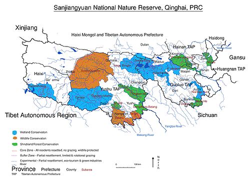
is considered to be located. The area around the peak is protected as part of the Sanjiangyuan National Nature Reserve
.
Tanggulashan Town is administratively divided into 7 village-level units ("administrative villages" (xingzhengcun) and "communities" (xingzhengshe)). The region is sparsely populated, with the registered population of 1,286 (year 2006) and the actually present population estimated at around 1,900. Most of these people live in several small villages located along the Golmud-Lhasa
highway and railway corridor (China National Highway 109
and Qinghai-Tibet Railway).
 188 local residents are members of the Communist Party of China
.
The main of these settlements, and the one that is marked on the maps at "Tanggulashan Town" (or, earlier, "Tanggulashan Township"; presumably, the place where is local government is based) is located near the highway and railway crossing of the Tuotuo River, which is the headwaters of the Yangtze. This settlement is served by the Tuotuohe railway station
. Other settlements in the same highway/railway corridor, further south, are Tongtian Heyan ("Tongtian River
side"), Yanshiping
(雁石坪), Wenquan, and Tanggula Bingzhan ("Tanggula Military Post").
At Tanggula Pass
on the southern border of the province, the railway leaves Qinghai for Tibet, and therefore the Tanggula Railway Station
, which is located a short distance south of the pass, is actually outside of Tanggula Town, and is already within the Tibetan Autonomous Region.
is a concern in the area, as it is throughout the southwestern Qinghai.
Projects are underway to restrict grazing in some areas, and to reduce the livestock population in Tanggulashan Town to what is thought to be the "scientifically sound" target of 53,600.
Besides overgrazing by livestock, the local pasture land also suffers depredation by rats. After some attempts to poison them (with obvious side effects), in 2009 the local authorities started a campaign to attract birds of prey to the area, hoping that they would help to keep the rat population under control. For this purpose, 830 bird perches were erected in the affected areas.
In 2007, it was reported that a factory producing traditional Tibetan carpets opened in the area, employing about 80 people.
Town (China)
When referring to political divisions of China, town is the standard English translation of the Chinese 鎮 . It is a fourth-level administrative unit, i.e...
in the southwest of Qinghai
Qinghai
Qinghai ; Oirat Mongolian: ; ; Salar:) is a province of the People's Republic of China, named after Qinghai Lake...
province, Western China
Western China
Western China , refers to the western part of China. In the definition of the Chinese government, Western China covers six provinces: Gansu, Guizhou, Qinghai, Shaanxi, Sichuan, and Yunnan; one municipality: Chongqing; and three autonomous regions: Ningxia, Tibet, and Xinjiang.-Administrative...
. It forms the southern exclave of the county-level city of Golmud
Golmud
Golmud , sometimes transliterated as Ge'ermu or Geermu, is a county-level city in Qinghai Province, Western China. Administrated by Haixi Mongol and Tibetan Autonomous Prefecture, it is the second largest city in Qinghai and the third largest in the Tibetan Plateau . The population is now about...
, in Haixi Mongol and Tibetan Autonomous Prefecture
Haixi Mongol and Tibetan Autonomous Prefecture
Haixi Mongol and Tibetan Autonomous Prefecture is an autonomous prefecture in northern Qinghai province of Western China. It has an area of and its capital is Delingha...
. Before the local administrative reform of 2005, it was known as Tanggulashan Township (唐古拉山乡).
Geography
Tanggulashan Town as an administrative unit that occupies 47540 square kilometres (18,355.3 sq mi) in the southwestern corner of Qinghai province. It borders on the Tibetan Autonomous Region in the south and west, and on Qinghai's Yushu Tibetan Autonomous Prefecture in the east and north. The western "panhandle" of Yushu Prefecture separates Tanggulashan Town from the rest of Haixi Prefecture, making it an exclave of Golmud City and of the Haixi Mongol and Tibetan Autonomous PrefectureHaixi Mongol and Tibetan Autonomous Prefecture
Haixi Mongol and Tibetan Autonomous Prefecture is an autonomous prefecture in northern Qinghai province of Western China. It has an area of and its capital is Delingha...
.
Tanggulashan Town is around 500 kilometres (310.7 mi) away (straight-line distance) both from the central city of Golmud and from the town of Gyêgu, the seat Yushu Prefecture, but it has practical road (and rail) connection only with the former.
As the name indicates, Tanggulashan Town is located in the central part of Tanggula Mountains
Tanggula Mountains
Tanggula Mountains Shanmai) are a mountain range in the central part of the Tibetan Plateau. Administratvely, the western part of the range is in Nagqu Prefecture of the Tibet Autonomous Region; the highest, central part, in the border area of Nagqu Prefecture and Tanggula Town of the Qinghai...
, at the elevations from 4700 metres (15,419.9 ft) and up. The most famous local feature is the Geladaindong Peak (at 6621 metres (21,722.4 ft) elevation), near which the source of the Yangtze River
Yangtze River
The Yangtze, Yangzi or Cháng Jiāng is the longest river in Asia, and the third-longest in the world. It flows for from the glaciers on the Tibetan Plateau in Qinghai eastward across southwest, central and eastern China before emptying into the East China Sea at Shanghai. It is also one of the...
is considered to be located. The area around the peak is protected as part of the Sanjiangyuan National Nature Reserve
Sanjiangyuan National Nature Reserve
The Sanjiangyuan National Nature Reserve The Sanjiangyuan National Nature Reserve The Sanjiangyuan National Nature Reserve (SNNR; ; Tibetan: (གཙང་གསུམ་འབུང་ཁུངས་རང་བྱུང་སྲུང་སྐྱོབ་ཁུལ།) also referred to as the Sanjiangyuan Nature Reserve, or the Three Rivers Nature Reserve, is the area of Qinghai...
.
Tanggulashan Town is administratively divided into 7 village-level units ("administrative villages" (xingzhengcun) and "communities" (xingzhengshe)). The region is sparsely populated, with the registered population of 1,286 (year 2006) and the actually present population estimated at around 1,900. Most of these people live in several small villages located along the Golmud-Lhasa
Lhasa
Lhasa is the administrative capital of the Tibet Autonomous Region in the People's Republic of China and the second most populous city on the Tibetan Plateau, after Xining. At an altitude of , Lhasa is one of the highest cities in the world...
highway and railway corridor (China National Highway 109
China National Highway 109
China National Highway 109 connects Beijing with Lhasa. It runs westwards of Beijing via Datong, Yinchuan and Xining to Golmud before turning southwest to Lhasa...
and Qinghai-Tibet Railway).
Communist Party of China
The Communist Party of China , also known as the Chinese Communist Party , is the founding and ruling political party of the People's Republic of China...
.
The main of these settlements, and the one that is marked on the maps at "Tanggulashan Town" (or, earlier, "Tanggulashan Township"; presumably, the place where is local government is based) is located near the highway and railway crossing of the Tuotuo River, which is the headwaters of the Yangtze. This settlement is served by the Tuotuohe railway station
Tuotuohe railway station
Tuotuohe railway station is a station on the Chinese Qingzang Railway. It is located near the railway bridge over the Tuotuo River , which is considered the headwaters of China's great Yangtze River...
. Other settlements in the same highway/railway corridor, further south, are Tongtian Heyan ("Tongtian River
Tongtian River
The Tongtian River is a section of the Yangtze River within China's Qinghai Province. . It is one of the...
side"), Yanshiping
Yanshiping
Yanshiping is a small community in the Tanggulashan Town of southwestern Qinghai, and a station of the same name on the Chinese Qingzang Railway.-See also:* Qingzang Railway* List of stations on Qingzang railway...
(雁石坪), Wenquan, and Tanggula Bingzhan ("Tanggula Military Post").
At Tanggula Pass
Tanggula Pass
The Tanggu La or Tanggu Pass is a wide mountain pass over 5000 meters elevation in the People's Republic of China used by the Qinghai–Tibet Highway and Railway to cross the Tanggula Mountains. These mountains form part of the watershed separating the Yangtze River to the north and a zone of...
on the southern border of the province, the railway leaves Qinghai for Tibet, and therefore the Tanggula Railway Station
Tanggula railway station
The Tanggula railway station is a railway station located in Amdo County, Tibet Autonomous Region, China, near the border with the Tanggula Town, Qinghai...
, which is located a short distance south of the pass, is actually outside of Tanggula Town, and is already within the Tibetan Autonomous Region.
Economy
The traditional occupation of the local residents is livestock (sheep) breeding. According to the local authorities in Golmud, overgrazingOvergrazing
Overgrazing occurs when plants are exposed to intensive grazing for extended periods of time, or without sufficient recovery periods. It can be caused by either livestock in poorly managed agricultural applications, or by overpopulations of native or non-native wild animals.Overgrazing reduces the...
is a concern in the area, as it is throughout the southwestern Qinghai.
Projects are underway to restrict grazing in some areas, and to reduce the livestock population in Tanggulashan Town to what is thought to be the "scientifically sound" target of 53,600.
Besides overgrazing by livestock, the local pasture land also suffers depredation by rats. After some attempts to poison them (with obvious side effects), in 2009 the local authorities started a campaign to attract birds of prey to the area, hoping that they would help to keep the rat population under control. For this purpose, 830 bird perches were erected in the affected areas.
In 2007, it was reported that a factory producing traditional Tibetan carpets opened in the area, employing about 80 people.