

Großer Knechtsand
Encyclopedia
Elbe
The Elbe is one of the major rivers of Central Europe. It rises in the Krkonoše Mountains of the northwestern Czech Republic before traversing much of Bohemia , then Germany and flowing into the North Sea at Cuxhaven, 110 km northwest of Hamburg...
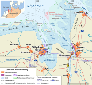
estuaries (in the Elbe-Weser Triangle
Elbe-Weser Triangle
The region between Bremen , Hamburg and Cuxhaven forms the Elbe-Weser Triangle in northern Germany. It is also colloquially referred to as the Nasses Dreieck or "Wet Triangle"...
) in the eastern part of Lower Saxony
Lower Saxony
Lower Saxony is a German state situated in north-western Germany and is second in area and fourth in population among the sixteen states of Germany...
's Wadden Sea
Wadden Sea
The Wadden Sea is an intertidal zone in the southeastern part of the North Sea. It lies between the coast of northwestern continental Europe and the range of Frisian Islands, forming a shallow body of water with tidal flats and wetlands. It is rich in biological diversity...
off the coast of North Germany. It lies between the islands of Mellum
Mellum
Mellum is an uninhabited East Frisian island lying southeast of Wangerooge, off the coastal settlements of Horumersiel and Schillig.Mellum formed as an island off the end of the Butjadingen peninsula – which divides the outflows into the Wadden Sea of the Jade and Weser rivers – only at...
(which is 16 km to the southwest) and Neuwerk
Neuwerk
Neuwerk is a Wadden Sea island on the German North Sea coast and a homonymous quarter of the city of Hamburg, Germany, in the borough Hamburg-Mitte...
(11 km northeast). The central area of the sandbank lies above the high water mark
High water mark
High water mark may refer to:*Ordinary high water mark, a landscape marking such as floodwater staining left by the highest level of water...
, forming the Hochsand of Hoher Knechtsand, which was formerly an island
Island
An island or isle is any piece of sub-continental land that is surrounded by water. Very small islands such as emergent land features on atolls can be called islets, cays or keys. An island in a river or lake may be called an eyot , or holm...
. The Hochsand lies 11 km west of the village of Berensch on the nearest part of the mainland in the in the borough of Cuxhaven) in Land Wursten
Land Wursten
Land Wursten is a Samtgemeinde in the district of Cuxhaven, in Lower Saxony, Germany. It is situated approximately 20 km southwest of Cuxhaven, and 15 km north of Bremerhaven...
.
The Hoher Knechtsand measures 2.5 km in an east-west direction and is between 600 metres wide in the west and 1.6 km wide in the east. The area of the sandbank above the high water mark is about 2.6 km².
The Großer Knechtsand, together with the island of Trischen
Trischen
Trischen is an uninhabited island in the Meldorf Bay, about 14 kilometres off the North Sea coast of Dithmarschen in north Germany – about 12 kilometres from the Trischendamm embankment. The island belongs to the municipality of Friedrichskoog and is only occupied from March to October by a bird...
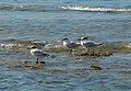
, is one of the most important moulting areas for the shelduck
Common Shelduck
The Common Shelduck is a waterfowl species shelduck genus Tadorna. It is widespread and common in Eurasia, mainly breeding in temperate and wintering in subtropical regions; in winter, it can also be found in the Maghreb...
, and, with Trischen, Norderoog
Norderoog
Norderoog is one of the ten German halligen islands of the North Frisian Islands in the Wadden Sea, which is part of the North Sea off the coast of Germany. It is only temporalily inhabited by a bird warden from March to October. The refuge hut at the northeastern end is called Jens Wand Hütte,...
and Minsener Oog
Minsener Oog
Minsener Oog, also Minser Oog or Minsener Oldeoog, is an uninhabited East Frisian island, that belongs to the parish of Wangerooge in the north German district of Friesland...
, has one of the largest and longest-lasting colonies of Sandwich Terns. Eider duck and common seal also occur here in large numbers.
East of the Großer Knechtsand lie the mudflat
Mudflat
Mudflats or mud flats, also known as tidal flats, are coastal wetlands that form when mud is deposited by tides or rivers. They are found in sheltered areas such as bays, bayous, lagoons, and estuaries. Mudflats may be viewed geologically as exposed layers of bay mud, resulting from deposition of...
s of Spiekaer Barre. To the north and south it is bordered by the tidal channels (Priele) of Westertill, Ostertill and Robins Balje. Further southeast is the Wurster Watt off the coast of Land Wursten.
To enable the population of Heligoland
Heligoland
Heligoland is a small German archipelago in the North Sea.Formerly Danish and British possessions, the islands are located in the Heligoland Bight in the south-eastern corner of the North Sea...
to return to their home, the then Chancellor, Konrad Adenauer
Konrad Adenauer
Konrad Hermann Joseph Adenauer was a German statesman. He was the chancellor of the West Germany from 1949 to 1963. He is widely recognised as a person who led his country from the ruins of World War II to a powerful and prosperous nation that had forged close relations with old enemies France,...
, offered the area around the Großer Knechtsand as an alternative site for military exercises. As a result, from 1952 the area acted as a target for practice bombing sharp explosive and incendiary bombs of the British Royal Air Force
Royal Air Force
The Royal Air Force is the aerial warfare service branch of the British Armed Forces. Formed on 1 April 1918, it is the oldest independent air force in the world...
instead of Heligoland. A few years later, environmental awareness had increased and, when the contract expired in 1957, it was not renewed. This important area for resting and moulting shelduck and other seabirds was designated in 1957 as the largest German nature reserve
Nature reserve
A nature reserve is a protected area of importance for wildlife, flora, fauna or features of geological or other special interest, which is reserved and managed for conservation and to provide special opportunities for study or research...
in Germany. Since 1986 the area has been part of the strictly protected 'quiet zone' of Lower Saxon Wadden Sea National Park
Lower Saxon Wadden Sea National Park
The Lower Saxon Wadden Sea National Park was established in 1986 and embraces the East Frisian Islands, mudflats and salt marshes between the Bay of Dollart on the border with the Netherlands in the west and Cuxhaven as far as the Outer Elbe shipping channel in the east. The national park has an...
.
About 2 km northwest of the Großer Knechtsand lies the sandbanks of Kleine Knechtsände (53°50′N 8°18′E).
Source
- Friedrich, Ernst Andreas (1980). Naturdenkmale Niedersachsens. Hanover, ISBN 3-7842-0227-6.