

Greenville, Jersey City
Encyclopedia
Greenville is the southernmost section of Jersey City
, New Jersey
.
In its broadest definition Greenville encompasses the area south of the West Side Branch
of Hudson-Bergen Light Rail
and north of the city line
with Bayonne
, between the Upper New York Bay
and the Newark Bay
, and corresponds to the postal area zip code
07305. The Claremont Section straddles Greenville and Bergen-Lafayette
.
The central core of Greenville (between Garfield Avenue
and West Side Avenue
) is primarily residential, the housing stock mostly one and two family homes and lowrise apartment buildings. Principal corridors include MLK Drive, Old Bergen Road
and Danforth Avenue
. This part of Greenville is home to the Afro-American Historical and Cultural Society Museum
at the Miller Branch of the Jersey City Public Library, Greenville Hospital, Jewish Hospital, Henry Snyder High School
, and New Jersey City University
all located on the district's main thoroughfare, Kennedy Boulevard
. The Bayview - New York Bay Cemetery is a prominent landmark. The part of Greenville at the city line is known as Curries Woods
.
East of New Jersey Turnpike
Newark Bay
Extension (Interstate 78
) lie the Greenville Yards, an intermodal facility, Port Jersey
, Port Liberté
, (a gated residential community), and the Caven Point Section of Liberty State Park
. Slightly further inland and parallel to the route of the Turnpike, was that of the Morris Canal
until abandoned in the 1920s. A small (filled-in) portion of the canal still exists in Country Village
, a neighborhood near Droyer's Point
and the West Side
.
Besides nearby Liberty State
other parks include Mercer Park
, Bayside, Columbia, and Fricchione. Cochrane Athletic Field is located near the Hudson Waterfront. Audubon Park is a city square.
 The Richard Street
and Danforth Avenue stations of the Hudson-Bergen Light Rail
are located on the district's east side east of Garfield Avenue
, while West Side Branch
Hudson-Bergen Light Rail
stations (including the MLK Station
) are on its northern perimeter, which overlaps Bergen-Lafayette
.
There is bus service along its north south-streets avenues: Ocean Avenue, Old Bergen Road
, Kennedy Boulevard
, and West Side Avenue
operated by
New Jersey Transit buses to Journal Square
, Exchange Place
, and Bayonne
, the Red & Tan buses 99s and 4.
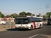
The Greenville Bus Garage on Old Bergen Road is one of the largest in Hudson, housing more than 120 buses for Routes: 6, 43, 80, 81, 87, 120, 126, 99.
and Raritan Indian
s at the time of European contact in the 17th century. They called the area on Bergen Neck
Minkakwa (alternatively spelled Minelque and Minackqua) meaning a place of good crossing. This is likely so because it was the most convenient pass between the two bays on either side of the neck. Interpreted as place where the coves meet, in this case where they are closest to each, it describes a spot advantageous for portage
. First settled by New Netherlander
s in 1647.
the Caven Point settlement on the west shore of the Upper New York Bay
between Pamrapo and Communipaw
was part of Pavonia
, which, upon receiving its municipal charter in 1661 was renamed Bergen
. The name Caven is a anglicisation
of the Dutch word Kewan, which in turn was a "Batavianized
" derivative of an Algonquian
word meaning peninsula.
by an Act of the New Jersey Legislature
on April 14, 1863, from portions of Bergen Town. It was absorbed into Jersey City on February 4, 1873, ending its life as an independent municipality.
As prices soar in other neighborhoods in New York City
and New Jersey, Greenville has become a destination for those who are seeking the next hot neighborhood.
Jersey City, New Jersey
Jersey City is the seat of Hudson County, New Jersey, United States.Part of the New York metropolitan area, Jersey City lies between the Hudson River and Upper New York Bay across from Lower Manhattan and the Hackensack River and Newark Bay...
, New Jersey
New Jersey
New Jersey is a state in the Northeastern and Middle Atlantic regions of the United States. , its population was 8,791,894. It is bordered on the north and east by the state of New York, on the southeast and south by the Atlantic Ocean, on the west by Pennsylvania and on the southwest by Delaware...
.
In its broadest definition Greenville encompasses the area south of the West Side Branch
West Side, Jersey City
The West Side of Jersey City is a made of several diverse neighborhoods on either side of West Side Avenue, one of the city's main shopping streets...
of Hudson-Bergen Light Rail
Hudson-Bergen Light Rail
The Hudson–Bergen Light Rail is a light rail system in Hudson County, New Jersey, United States. Owned by New Jersey Transit and operated by the 21st Century Rail Corporation, it connects the communities of Bayonne, Jersey City, Hoboken, Weehawken, Union City , and North Bergen.The system began...
and north of the city line
Curries Woods
Curries Woods is a neighborhood in the southern part of Greenville in Jersey City, New Jersey bordering Bayonne. It was named after James Curie, who was on the town Committee for Greenville when it was its own Township in the 19th century...
with Bayonne
Bayonne, New Jersey
Bayonne is a city in Hudson County, New Jersey, United States. Located in the Gateway Region, Bayonne is a peninsula that is situated between Newark Bay to the west, the Kill van Kull to the south, and New York Bay to the east...
, between the Upper New York Bay
Upper New York Bay
Upper New York Bay, or Upper Bay, is the traditional heart of the Port of New York and New Jersey, and often called New York Harbor. It is enclosed by the New York City boroughs of Manhattan, Brooklyn, and Staten Island and the Hudson County, New Jersey municipalities of Jersey City and Bayonne.It...
and the Newark Bay
Newark Bay
Newark Bay is a tidal bay at the confluence of the Passaic and Hackensack Rivers in northeastern New Jersey. It is home to the Port Newark-Elizabeth Marine Terminal, the largest container shipping facility in Port of New York and New Jersey, 3rd largest and one of busiest in the United States...
, and corresponds to the postal area zip code
ZIP Code
ZIP codes are a system of postal codes used by the United States Postal Service since 1963. The term ZIP, an acronym for Zone Improvement Plan, is properly written in capital letters and was chosen to suggest that the mail travels more efficiently, and therefore more quickly, when senders use the...
07305. The Claremont Section straddles Greenville and Bergen-Lafayette
Bergen-Lafayette, Jersey City
Bergen-Lafayette is a section of Jersey City, New Jersey.As its name implies, Bergen-Lafayette is made of different neighborhoods. It lies west-southwest of Downtown and Liberty State Park...
.
The central core of Greenville (between Garfield Avenue
Bergen Point Plank Road
The Jersey City and Bergen Point Plank Road was a road in the 19th century in Hudson County, New Jersey which ran between Paulus Hook and Bergen Point. The company which built the road received its charter on March 6, 1850. It has subsequently become Grand Street and Garfield Avenue in Jersey City...
and West Side Avenue
West Side Avenue (HBLR station)
-External links:*...
) is primarily residential, the housing stock mostly one and two family homes and lowrise apartment buildings. Principal corridors include MLK Drive, Old Bergen Road
Old Bergen Road
Old Bergen Road is located in the Greenville Section of Jersey City, New Jersey, and is designated Hudson County Route 601. It runs between Kennedy Boulevard at the north and County Route 707 to the south at Curries Woods...
and Danforth Avenue
Danforth Avenue (Hudson County)
-Station:The Danforth Avenue Station on the Hudson-Bergen Light Rail is located one block east of Garfield Avenue, near the location of the former Central Railroad of New Jersey Greenville station.-Service:...
. This part of Greenville is home to the Afro-American Historical and Cultural Society Museum
Afro-American Historical and Cultural Society Museum
The Afro-American Historical and Cultural Society Museum is located is on the upper floor of the Miller Branch of the Jersey City, New Jersey Public Library, its collection is dedicated to the African American experience....
at the Miller Branch of the Jersey City Public Library, Greenville Hospital, Jewish Hospital, Henry Snyder High School
Henry Snyder High School
Henry Snyder High School is a four-year performing arts public high school located in the Greenville section of Jersey City, New Jersey, United States, operating as part of the Jersey City Public Schools...
, and New Jersey City University
New Jersey City University
New Jersey City University is a public university in Jersey City, New Jersey, USA. It is a member of the New Jersey Association of State Colleges and Universities....
all located on the district's main thoroughfare, Kennedy Boulevard
County Route 501 (New Jersey)
County Route 501 is a county highway in New Jersey in two sections spanning Middlesex, Hudson and Bergen Counties. The southern section runs from South Plainfield to Perth Amboy, the northern section runs from Bayonne to Rockleigh, and the two sections are connected by New York State Route 440...
. The Bayview - New York Bay Cemetery is a prominent landmark. The part of Greenville at the city line is known as Curries Woods
Curries Woods
Curries Woods is a neighborhood in the southern part of Greenville in Jersey City, New Jersey bordering Bayonne. It was named after James Curie, who was on the town Committee for Greenville when it was its own Township in the 19th century...
.
East of New Jersey Turnpike
New Jersey Turnpike
The New Jersey Turnpike is a toll road in New Jersey, maintained by the New Jersey Turnpike Authority. According to the International Bridge, Tunnel and Turnpike Association, the Turnpike is the nation's sixth-busiest toll road and is among one of the most heavily traveled highways in the United...
Newark Bay
Newark Bay Bridge
The Newark Bay Bridge is a steel through arch bridge that is continuous across three spans. It crosses Newark Bay and connects the cities of Newark and Bayonne in New Jersey...
Extension (Interstate 78
Interstate 78 in New Jersey
Interstate 78 is an east–west route stretching from Union Township, Lebanon County, Pennsylvania to New York City. In New Jersey, I-78 is called the Phillipsburg–Newark Expressway and the Newark Bay Extension of the New Jersey Turnpike...
) lie the Greenville Yards, an intermodal facility, Port Jersey
Port Jersey
Port Jersey is an intermodal freight transport facility that includes a container terminal located on the Upper New York Bay in the Port of New York and New Jersey. The municipal border of the Hudson County, New Jersey cities of Jersey City and Bayonne runs along the long pier extending into the bay...
, Port Liberté
Port Liberté, Jersey City
Port Liberté is a section of Jersey City located on Caven Point that used to be one of last natural sand beaches on the Upper New York Bay. The community is a European style village located along the western side of Upper New York Bay. The community has canals, gardens, playgrounds, and even a...
, (a gated residential community), and the Caven Point Section of Liberty State Park
Liberty State Park
Liberty State Park is located on Upper New York Bay in Jersey City, New Jersey, opposite the Statue of Liberty and Ellis Island. The park opened in 1976 to coincide with bicentennial celebrations and is operated and maintained by the New Jersey Division of Parks and Forestry.-Geography and...
. Slightly further inland and parallel to the route of the Turnpike, was that of the Morris Canal
Morris Canal
The Morris Canal was an anthracite-carrying canal that incorporated a series of water-driven inclined planes in its course across northern New Jersey in the United States. It was in use for about a century — from the late 1820s to the 1920s....
until abandoned in the 1920s. A small (filled-in) portion of the canal still exists in Country Village
Country Village, Jersey City
Country Village is an residential enclave in the southwestern corner of the Greenville section of Jersey City, New Jersey that was built as planned community in the early 1960s.-Design and geography:...
, a neighborhood near Droyer's Point
Droyer's Point
Droyer's Point is a section of Jersey City, New Jersey at Newark Bay.-Geography:In the southwestern part of the of the city, Droyer's Point is located on the Newark Bay. Its eastern perimeter is New Jersey Route 440. The point is entered from the highway's intersection with Danforth Avenue...
and the West Side
West Side, Jersey City
The West Side of Jersey City is a made of several diverse neighborhoods on either side of West Side Avenue, one of the city's main shopping streets...
.
Besides nearby Liberty State
Liberty State Park
Liberty State Park is located on Upper New York Bay in Jersey City, New Jersey, opposite the Statue of Liberty and Ellis Island. The park opened in 1976 to coincide with bicentennial celebrations and is operated and maintained by the New Jersey Division of Parks and Forestry.-Geography and...
other parks include Mercer Park
Curries Woods
Curries Woods is a neighborhood in the southern part of Greenville in Jersey City, New Jersey bordering Bayonne. It was named after James Curie, who was on the town Committee for Greenville when it was its own Township in the 19th century...
, Bayside, Columbia, and Fricchione. Cochrane Athletic Field is located near the Hudson Waterfront. Audubon Park is a city square.
Public transportation
Richard Street (HBLR station)
Richard Street is a station on the Hudson-Bergen Light Rail located east of Garfield Avenue adjacent to Bayside Park in the Greenville Section of Jersey City, New Jersey.-Service:...
and Danforth Avenue stations of the Hudson-Bergen Light Rail
Hudson-Bergen Light Rail
The Hudson–Bergen Light Rail is a light rail system in Hudson County, New Jersey, United States. Owned by New Jersey Transit and operated by the 21st Century Rail Corporation, it connects the communities of Bayonne, Jersey City, Hoboken, Weehawken, Union City , and North Bergen.The system began...
are located on the district's east side east of Garfield Avenue
Bergen Point Plank Road
The Jersey City and Bergen Point Plank Road was a road in the 19th century in Hudson County, New Jersey which ran between Paulus Hook and Bergen Point. The company which built the road received its charter on March 6, 1850. It has subsequently become Grand Street and Garfield Avenue in Jersey City...
, while West Side Branch
West Side, Jersey City
The West Side of Jersey City is a made of several diverse neighborhoods on either side of West Side Avenue, one of the city's main shopping streets...
Hudson-Bergen Light Rail
Hudson-Bergen Light Rail
The Hudson–Bergen Light Rail is a light rail system in Hudson County, New Jersey, United States. Owned by New Jersey Transit and operated by the 21st Century Rail Corporation, it connects the communities of Bayonne, Jersey City, Hoboken, Weehawken, Union City , and North Bergen.The system began...
stations (including the MLK Station
Martin Luther King Drive (HBLR station)
Martin Luther King Drive is a street named for Martin Luther King, Jr. in Jersey City, New Jersey with the designation Hudson County Route 609 and the name of the Hudson Bergen Light Rail Station on it...
) are on its northern perimeter, which overlaps Bergen-Lafayette
Bergen-Lafayette, Jersey City
Bergen-Lafayette is a section of Jersey City, New Jersey.As its name implies, Bergen-Lafayette is made of different neighborhoods. It lies west-southwest of Downtown and Liberty State Park...
.
There is bus service along its north south-streets avenues: Ocean Avenue, Old Bergen Road
Old Bergen Road
Old Bergen Road is located in the Greenville Section of Jersey City, New Jersey, and is designated Hudson County Route 601. It runs between Kennedy Boulevard at the north and County Route 707 to the south at Curries Woods...
, Kennedy Boulevard
County Route 501 (New Jersey)
County Route 501 is a county highway in New Jersey in two sections spanning Middlesex, Hudson and Bergen Counties. The southern section runs from South Plainfield to Perth Amboy, the northern section runs from Bayonne to Rockleigh, and the two sections are connected by New York State Route 440...
, and West Side Avenue
West Side, Jersey City
The West Side of Jersey City is a made of several diverse neighborhoods on either side of West Side Avenue, one of the city's main shopping streets...
operated by
New Jersey Transit buses to Journal Square
Journal Square
Journal Square is a business district, residential area, and transportation hub in Jersey City, New Jersey, which takes its name from the newspaper Jersey Journal whose headquarters are located there. The "square" itself is at the intersection of Kennedy Boulevard and Bergen Avenues...
, Exchange Place
Exchange Place, Jersey City
Exchange Place is a district of Downtown Jersey City, New Jersey that is sometimes referred to as "Wall Street West" due to the concentration of financial concerns which have offices there...
, and Bayonne
Bayonne
Bayonne is a city and commune in south-western France at the confluence of the Nive and Adour rivers, in the Pyrénées-Atlantiques department, of which it is a sub-prefecture...
, the Red & Tan buses 99s and 4.
The Greenville Bus Garage on Old Bergen Road is one of the largest in Hudson, housing more than 120 buses for Routes: 6, 43, 80, 81, 87, 120, 126, 99.
Minkakwa, Kewan, and Pamrapo
What became Greenville was the territory of the HackensackHackensack (Native Americans)
Hackensack was the exonym given to a band of Lenape, a Native American people is a European derivation of the Lenape word for what is now the region of northeastern New Jersey along the Hudson and Hackensack Rivers.-Territory and Society:...
and Raritan Indian
Native Americans in the United States
Native Americans in the United States are the indigenous peoples in North America within the boundaries of the present-day continental United States, parts of Alaska, and the island state of Hawaii. They are composed of numerous, distinct tribes, states, and ethnic groups, many of which survive as...
s at the time of European contact in the 17th century. They called the area on Bergen Neck
Bergen Neck
Bergen Neck is a name for the peninsula between the Upper New York Bay and the Newark Bay in the Hudson County, New Jersey municipalities of Bayonne and Jersey City...
Minkakwa (alternatively spelled Minelque and Minackqua) meaning a place of good crossing. This is likely so because it was the most convenient pass between the two bays on either side of the neck. Interpreted as place where the coves meet, in this case where they are closest to each, it describes a spot advantageous for portage
Portage
Portage or portaging refers to the practice of carrying watercraft or cargo over land to avoid river obstacles, or between two bodies of water. A place where this carrying occurs is also called a portage; a person doing the carrying is called a porter.The English word portage is derived from the...
. First settled by New Netherlander
New Netherlander
New Netherlanders were residents of New Netherland, the seventeenth century colonial province of the Republic of the Seven United Netherlands on the northeastern coast of North America, centered around the Hudson River and New York Bay, and at the end of the colony in the Delaware Valley.The...
s in 1647.
the Caven Point settlement on the west shore of the Upper New York Bay
Upper New York Bay
Upper New York Bay, or Upper Bay, is the traditional heart of the Port of New York and New Jersey, and often called New York Harbor. It is enclosed by the New York City boroughs of Manhattan, Brooklyn, and Staten Island and the Hudson County, New Jersey municipalities of Jersey City and Bayonne.It...
between Pamrapo and Communipaw
Communipaw
Communipaw is a section of Jersey City, New Jersey west of Liberty State Park and east of Bergen Hill, and site of one the earliest European settlements in North America. It gives its name to the historic avenue which runs from its eastern end near LSP Station through the neighborhoods of...
was part of Pavonia
Pavonia, New Netherland
Pavonia was the first European settlement on the west bank of the North River that was part of the 17th century province of New Netherland in what would become today's Hudson County, New Jersey.-Hudson and the Hackensack:...
, which, upon receiving its municipal charter in 1661 was renamed Bergen
Bergen, New Netherland
Bergen was a part of the 17th century province of New Netherland, in the area in northeastern New Jersey along the Hudson and Hackensack Rivers that would become contemporary Hudson and Bergen Counties...
. The name Caven is a anglicisation
Anglicisation
Anglicisation, or anglicization , is the process of converting verbal or written elements of any other language into a form that is more comprehensible to an English speaker, or, more generally, of altering something such that it becomes English in form or character.The term most often refers to...
of the Dutch word Kewan, which in turn was a "Batavianized
Batavians
The Batavi were an ancient Germanic tribe, originally part of the Chatti, reported by Tacitus to have lived around the Rhine delta, in the area that is currently the Netherlands, "an uninhabited district on the extremity of the coast of Gaul, and also of a neighbouring island, surrounded by the...
" derivative of an Algonquian
Algonquian languages
The Algonquian languages also Algonkian) are a subfamily of Native American languages which includes most of the languages in the Algic language family. The name of the Algonquian language family is distinguished from the orthographically similar Algonquin dialect of the Ojibwe language, which is a...
word meaning peninsula.
Bergen, Greenville, Jersey
During the British and early American colonial era the area was part of Bergen Township. The 19th century Jersey City and Bergen Point Plank Road (today's Garfield Avenue) ran through Greenville (from Paulus Hook to Bergen Point). Greenville became part of the newly formed Hudson County in 1840. The town grew as a fashionable suburb of New York.Greenville Township was incorporated as a townshipTownship (New Jersey)
A township, in the context of New Jersey local government, refers to one of five types and one of eleven forms of municipal government. As a political entity, a township is a full-fledged municipality, on par with any town, city, borough, or village, collecting property taxes and providing...
by an Act of the New Jersey Legislature
New Jersey Legislature
The New Jersey Legislature is the legislative branch of the government of the U.S. state of New Jersey. In its current form, as defined by the New Jersey Constitution of 1947, the Legislature consists of two houses: the General Assembly and the Senate...
on April 14, 1863, from portions of Bergen Town. It was absorbed into Jersey City on February 4, 1873, ending its life as an independent municipality.
Crime and Gentrification
In 2005, due to a huge surge in murders and crime the city enacted a curfew for business owners on some of Greenville's most crime-ridden streets, including Martin Luther King Drive and Ocean Avenue. Most of the 39 murders in 2005 occurred within the borders of this Jersey City neighborhood. Many drug gangs and street gangs have staked out their territories along this neighborhood's most blighted street, and in 2005 the FBI targeted a group of drug dealers that were entrenched on the corner of Lexington and Bergen Avenues, the base of operations for cocaine distribution and an area where numerous drug- and gang-related murders and shootings had taken place between 1993 and 2002.As prices soar in other neighborhoods in New York City
New York City
New York is the most populous city in the United States and the center of the New York Metropolitan Area, one of the most populous metropolitan areas in the world. New York exerts a significant impact upon global commerce, finance, media, art, fashion, research, technology, education, and...
and New Jersey, Greenville has become a destination for those who are seeking the next hot neighborhood.
Links to articles related to Greenville
- Bergen NeckBergen NeckBergen Neck is a name for the peninsula between the Upper New York Bay and the Newark Bay in the Hudson County, New Jersey municipalities of Bayonne and Jersey City...
- Black Tom
- Canal CrossingCanal Crossing, Jersey CityCanal Crossing is a New Urbanism project on the eastern side of Jersey City, New Jersey between the Greenville Section, Bergen-Lafayette and Liberty State Park...
- Curries WoodsCurries WoodsCurries Woods is a neighborhood in the southern part of Greenville in Jersey City, New Jersey bordering Bayonne. It was named after James Curie, who was on the town Committee for Greenville when it was its own Township in the 19th century...
- Kennedy BoulevardCounty Route 501 (New Jersey)County Route 501 is a county highway in New Jersey in two sections spanning Middlesex, Hudson and Bergen Counties. The southern section runs from South Plainfield to Perth Amboy, the northern section runs from Bayonne to Rockleigh, and the two sections are connected by New York State Route 440...
- Cross-Harbor Rail TunnelCross-Harbor Rail TunnelThe Cross-Harbor Rail Tunnel is a proposed freight rail transport tunnel under Upper New York Bay in the Port of New York and New Jersey between northeastern New Jersey and Long Island, including southern and eastern New York City.-Background:Direct connections for rail freight between Long Island...
- Hackensack RiverWalkHackensack RiverWalkHackensack RiverWalk a is partially constructed greenway along the Newark Bay and Hackensack River on the west side of the Bergen Neck peninsula in Hudson County, New Jersey...
- Hudson River Waterfront WalkwayHudson River Waterfront WalkwayThe Hudson River Waterfront Walkway, also known as the Hudson River Walkway, is an ongoing and incomplete project located on Kill van Kull and the western shore of Upper New York Bay and the Hudson River, implemented as part of a New Jersey state-mandated master plan to connect the municipalities...
- Greenville and Hudson RailwayLehigh Valley Terminal RailwayThe Lehigh Valley Terminal Railway was a Lehigh Valley Railroad company organized in 1891 through the consolidation of the companies that formed the Lehigh Valley's route from South Plainfield through Newark to Jersey City via its bridge across Newark Bay...
- Liberty National Golf ClubLiberty National Golf ClubLiberty National Golf Club is a country club in Jersey City, New Jersey with a 7,346 yard course designed by Robert E. Cupp and Tom Kite. The club cost over $250 million to build, making it one of the most expensive golf courses in history. Club designers added amenities such as an on-site...
- Liberty State ParkLiberty State ParkLiberty State Park is located on Upper New York Bay in Jersey City, New Jersey, opposite the Statue of Liberty and Ellis Island. The park opened in 1976 to coincide with bicentennial celebrations and is operated and maintained by the New Jersey Division of Parks and Forestry.-Geography and...
- List of neighborhoods in Jersey City, New Jersey
- Morris CanalMorris CanalThe Morris Canal was an anthracite-carrying canal that incorporated a series of water-driven inclined planes in its course across northern New Jersey in the United States. It was in use for about a century — from the late 1820s to the 1920s....
- New Jersey City UniversityNew Jersey City UniversityNew Jersey City University is a public university in Jersey City, New Jersey, USA. It is a member of the New Jersey Association of State Colleges and Universities....
- New Jersey Route 185New Jersey Route 185Route 185 is a short state highway in Jersey City in the U.S. state of New Jersey, between Route 440 and Linden Avenue. Route 185 is a freeway in the Greenville neighborhood of Jersey City. It is parallel to Interstate 78 on the eastern side...
- Red & Tan in Hudson County
- Roosevelt StadiumRoosevelt StadiumRoosevelt Stadium was a baseball park at Droyer's Point in Jersey City, New Jersey. It opened in April 1937 and hosted high-minor league baseball, seven major league baseball games, plus championship boxing matches, top-name musical acts, important regional high school football and even soccer...
- Route 440 (New Jersey)Route 440 (New Jersey)Route 440 is a state highway in New Jersey, United States. It is composed of two segments, a freeway in Middlesex County linking Interstate 287 and the New Jersey Turnpike in Edison to the Outerbridge Crossing in Perth Amboy and a four-lane divided highway in Hudson County running from the...