

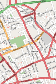
Gray's Inn Road
Encyclopedia
Central London
Central London is the innermost part of London, England. There is no official or commonly accepted definition of its area, but its characteristics are understood to include a high density built environment, high land values, an elevated daytime population and a concentration of regionally,...
, in the London Borough of Camden
London Borough of Camden
In 1801, the civil parishes that form the modern borough were already developed and had a total population of 96,795. This continued to rise swiftly throughout the 19th century, as the district became built up; reaching 270,197 in the middle of the century...
. (The street signs vary, with and without the apostrophe.) It is named after Gray's Inn
Gray's Inn
The Honourable Society of Gray's Inn, commonly known as Gray's Inn, is one of the four Inns of Court in London. To be called to the Bar and practise as a barrister in England and Wales, an individual must belong to one of these Inns...
, one of the main Inns of Court
Inns of Court
The Inns of Court in London are the professional associations for barristers in England and Wales. All such barristers must belong to one such association. They have supervisory and disciplinary functions over their members. The Inns also provide libraries, dining facilities and professional...
. The road starts in Holborn
Holborn
Holborn is an area of Central London. Holborn is also the name of the area's principal east-west street, running as High Holborn from St Giles's High Street to Gray's Inn Road and then on to Holborn Viaduct...
, near Chancery Lane tube station
Chancery Lane tube station
Chancery Lane is a London Underground station in central London. It is on the Central Line between St. Paul's and Holborn stations. The station is located at the junction of High Holborn, Hatton Garden and Gray's Inn Road with subway entrances giving access to the ticket office under the roadway...
and the boundaries of the City of London
City of London
The City of London is a small area within Greater London, England. It is the historic core of London around which the modern conurbation grew and has held city status since time immemorial. The City’s boundaries have remained almost unchanged since the Middle Ages, and it is now only a tiny part of...
and the London Borough of Islington
London Borough of Islington
The London Borough of Islington is a London borough in Inner London. It was formed in 1965 by merging the former metropolitan boroughs of Islington and Finsbury. The borough contains two Westminster parliamentary constituencies, Islington North and Islington South & Finsbury...
. From here it goes north and slightly west, forming the boundary between Clerkenwell
Clerkenwell
Clerkenwell is an area of central London in the London Borough of Islington. From 1900 to 1965 it was part of the Metropolitan Borough of Finsbury. The well after which it was named was rediscovered in 1924. The watchmaking and watch repairing trades were once of great importance...
to the east and Holborn
Holborn
Holborn is an area of Central London. Holborn is also the name of the area's principal east-west street, running as High Holborn from St Giles's High Street to Gray's Inn Road and then on to Holborn Viaduct...
, Bloomsbury
Bloomsbury
-Places:* Bloomsbury is an area in central London.* Bloomsbury , related local government unit* Bloomsbury, New Jersey, New Jersey, USA* Bloomsbury , listed on the NRHP in Maryland...
and finally St Pancras
St Pancras, London
St Pancras is an area of London. For many centuries the name has been used for various officially-designated areas, but now is used informally and rarely having been largely superseded by several other names for overlapping districts.-Ancient parish:...
to the west.
Along its course the road passes the Eastman Dental Hospital
Eastman Dental Hospital
The Eastman Dental Hospital is a specialist hospital for dental treatment in London, United Kingdom and forms a part of the University College London Hospitals NHS Foundation Trust...
and the UCL Eastman Dental Institute
UCL Eastman Dental Institute
The UCL Eastman Dental Institute is an academic department of the Faculty of Medical Sciences of University College London located in London, United Kingdom...
, Gray's Inn
Gray's Inn
The Honourable Society of Gray's Inn, commonly known as Gray's Inn, is one of the four Inns of Court in London. To be called to the Bar and practise as a barrister in England and Wales, an individual must belong to one of these Inns...
, ITN, ITV
ITV
ITV is the major commercial public service TV network in the United Kingdom. Launched in 1955 under the auspices of the Independent Television Authority to provide competition to the BBC, it is also the oldest commercial network in the UK...
and the London Welsh Centre
London Welsh Centre
The London Welsh Centre is a community and arts centre on Gray's Inn Road, in the London Borough of Camden. The Centre is owned and run by the London Welsh Trust....
. Near the north end of the road, where it meets Cromer Street
Cromer Street
Cromer Street is a road in Kings Cross in central London, England, UK. It starts in the west at Judd Street, then goes east, ending at Gray's Inn Road. It gave access from Gray's Inn Road to Greenland Place and a bowling green. It was formerly called Lucas Street but was renamed Cromer Street in...
and Acton Street, it turns into a one-way system heading towards Kings Cross station.
Throughout its route the road keeps to the higher ground, above the valley of the River Fleet
River Fleet
The River Fleet is the largest of London's subterranean rivers. Its two headwaters are two streams on Hampstead Heath; each is now dammed into a series of ponds made in the 18th century, the Hampstead Ponds and the Highgate Ponds. At the south edge of Hampstead Heath these two streams flow...
to the east. In earlier times it was the principal route from London to Hampstead
Hampstead
Hampstead is an area of London, England, north-west of Charing Cross. Part of the London Borough of Camden in Inner London, it is known for its intellectual, liberal, artistic, musical and literary associations and for Hampstead Heath, a large, hilly expanse of parkland...
.
History
The area of Gray's Inn Road was clearly populated from palaeolithic times and a gravelGravel
Gravel is composed of unconsolidated rock fragments that have a general particle size range and include size classes from granule- to boulder-sized fragments. Gravel can be sub-categorized into granule and cobble...
bed off Gray's Inn Lane (see below) was the find spot for the c.350,000 year-old Gray's Inn Lane Hand Axe
Gray's Inn Lane Hand Axe
The Gray's Inn Lane Hand Axe is a pointed flint hand axe, found buried in gravel under Gray's Inn Lane, London, England, by pioneering archaeologist John Conyers in 1679, and now in the British Museum...
in 1679, one of the important artefacts in the emerging consciousness of human antiquity, now in the British Museum
British Museum
The British Museum is a museum of human history and culture in London. Its collections, which number more than seven million objects, are amongst the largest and most comprehensive in the world and originate from all continents, illustrating and documenting the story of human culture from its...
. Given the road's height above the Fleet valley, it may have formed part of an ancient trackway.
The manor of Portpool
Portpool
Portpool was a manor or soke in the district of Holborn, London. It is not recorded in the Domesday Book but references to it occur from the 12th century onwards. For many years it was owned by the Dean and Chapter of St Paul's Cathedral, who let it out to the Grey family...
formerly existed in the same area as Gray's Inn
Gray's Inn
The Honourable Society of Gray's Inn, commonly known as Gray's Inn, is one of the four Inns of Court in London. To be called to the Bar and practise as a barrister in England and Wales, an individual must belong to one of these Inns...
, and although the manor is not mentioned in the Domesday Book
Domesday Book
Domesday Book , now held at The National Archives, Kew, Richmond upon Thames in South West London, is the record of the great survey of much of England and parts of Wales completed in 1086...
it came into possession of the Dean and Chapter of St Paul's Cathedral
St Paul's Cathedral
St Paul's Cathedral, London, is a Church of England cathedral and seat of the Bishop of London. Its dedication to Paul the Apostle dates back to the original church on this site, founded in AD 604. St Paul's sits at the top of Ludgate Hill, the highest point in the City of London, and is the mother...
and may have formed a separate estate of one of the Canons. From at least the 13th century onwards it was in the possession of the Grey
Reginald de Grey, 1st Baron Grey de Wilton
Reginald de Grey, 1st Baron Grey de Wilton was an English nobleman for whom one of the four Inns of Court is named. He was son of Sir John de Grey and grandson of Henry de Grey...
family, after whom Gray's Inn
Gray's Inn
The Honourable Society of Gray's Inn, commonly known as Gray's Inn, is one of the four Inns of Court in London. To be called to the Bar and practise as a barrister in England and Wales, an individual must belong to one of these Inns...
is named.
The name "Purtepol Street" is recorded in the time of Henry III
Henry III of England
Henry III was the son and successor of John as King of England, reigning for 56 years from 1216 until his death. His contemporaries knew him as Henry of Winchester. He was the first child king in England since the reign of Æthelred the Unready...
and this may be the first reference to the current Gray's Inn Road. In a document of 1299 it is called "Street of Pourtepol without London", which is appropriate as it lies only just outside the boundary of the City
City of London
The City of London is a small area within Greater London, England. It is the historic core of London around which the modern conurbation grew and has held city status since time immemorial. The City’s boundaries have remained almost unchanged since the Middle Ages, and it is now only a tiny part of...
. In a document of 1468 the road is called "Graysynlane, otherwise Portpole Lane". Today's Portpool Lane, which leads off Gray's Inn Road to the east, is a separate road which is not mentioned prior to 1641.
On the Agas
Ralph Agas
Ralph Agas , English land surveyor, was born at Stoke-by-Nayland, Suffolk, about 1540, and entered upon the practice of his profession in 1566....
map of c.1570 "Greys ynne la." is shown leading from Holborn Bars to Gray's Inn
Gray's Inn
The Honourable Society of Gray's Inn, commonly known as Gray's Inn, is one of the four Inns of Court in London. To be called to the Bar and practise as a barrister in England and Wales, an individual must belong to one of these Inns...
, from where it becomes an unnamed track leading into the country. John Ogilby
John Ogilby
John Ogilby was a Scottish translator, impresario and cartographer. Best known for publishing the first British road atlas, he was also a successful translator, noted for publishing his work in handsome illustrated editions.-Life:Ogilby was born in or near Killemeare in November 1600...
and William Morgan
William Morgan (cartographer)
William Morgan was a cartographer in England during the 17th century. He was the step-grandson of John Ogilby and, following Ogilby's death in 1676, carried on the cartographic publications that Ogilby had started, including "Britannia" and a large map of the City of London.-Source:*The A to Z of...
's map of 1676 shows "Grayes-Inn Lane" which is clearly built up as far as Elm Street, although that is the limit of the map. John Rocque
John Rocque
John Rocque was a surveyor and cartographer.Rocque was born no later than 1709, since that was the year he moved to England with his parents, who were French Huguenot émigrés...
's map of 1738 depicts "Grays Inn Lane" which clearly applies to the stretch from Holborn to the edge of the built up area (somewhat south of the present Calthorpe Street), but when it passes into the country it is called "Road to Hampstead
Hampstead
Hampstead is an area of London, England, north-west of Charing Cross. Part of the London Borough of Camden in Inner London, it is known for its intellectual, liberal, artistic, musical and literary associations and for Hampstead Heath, a large, hilly expanse of parkland...
and Highgate
Highgate
Highgate is an area of North London on the north-eastern corner of Hampstead Heath.Highgate is one of the most expensive London suburbs in which to live. It has an active conservation body, the Highgate Society, to protect its character....
".
Richard Horwood
Richard Horwood
Richard Horwood was a surveyor and cartographer. In 1795 he published a Plan of the Cities of London and Westminster the Borough of Southwark and Parts adjoining Shewing every House, at a scale of 26 inches to the mile. At the time this was the largest map ever printed in Britain.Horwood also...
's map (updated by William Faden in 1813) calls the whole stretch from Holborn
Holborn
Holborn is an area of Central London. Holborn is also the name of the area's principal east-west street, running as High Holborn from St Giles's High Street to Gray's Inn Road and then on to Holborn Viaduct...
to modern Kings Cross "Grays Inn Lane", but by the mid-19th century it is Gray's Inn Road.
The Bourne Estate
Bourne estate
The Bourne Estate is a housing estate to the east of Gray's Inn Field in Central London. It is bounded by Clerkenwell Road to the north, Gray's Inn Road to the west, Leather Lane to the east and Baldwins Gardens to the south...
is a group of well-regarded Edwardian tenement blocks southeast of the junction with Clerkenwell Road.