

John Rocque
Encyclopedia
John Rocque was a surveyor and cartographer.
Rocque was born no later than 1709, since that was the year he moved to England with his parents, who were French Huguenot
émigrés. He became a godfather in 1728, which suggests he was at least twenty-one years old by that time.
In addition to his work as surveyor and mapmaker, Rocque was an engraver and map-seller. He was also involved in some way in gardening as a young man, living with his brother Bartholomew, who was a landscape gardener, and producing plans for parterre
s, perhaps recording pre-existing designs, but few details of this work are known. Roque produced engraved plans of the gardens at Wrest Park
(1735), Claremont (1738), Charles Hamilton's naturalistic landscape garden at Painshill Park
, Surrey (1744), Wanstead House
(1745) and Wilton House
(1746).
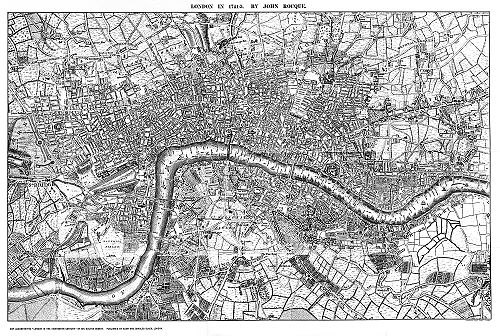
Rocque is now mainly remembered for his map of London. He began work on this in 1737 and it was published in 24 printed sheets in 1747. It was by far the most detailed map of London published up to that time, and remains an important historical resource.
The map of London and his other maps brought him an appointment as cartographer to the Prince of Wales
in 1751. A fire in 1750 destroyed his premises and stock, but by 1753 he was employing ten draughtsmen, and The Small British Atlas: Being a New set of Maps of all the Counties of England and Wales appeared. There was a second edition in 1762.
He also surveyed and published maps of Middlesex, Oxford, Barks, & Buckinghamshire in 1760.
His 1756 map of Dublin featured on an Irish ten pound banknote.
The Area around Dublin city on covered on 4 maps. They extended as far as Skerries and Cardy Rocks to the North, Carton House to the west, Blessington to the south west,and Enniskerry to the south.
The map of the lands around Dublin City is engraved with the following text:
"To The High Puifsant and moft Noble Prince
John - Duke of Bedford
Marquefs of Taviftock and Earl of Bedford
Baron Howland of Stratham, one of the Lords of his
Majefties Most Honourable Privy Council
Lord Lieutenant and Custos Rotulorum of the county
and Town of Bedford. And of the County of Devon. &
City of Exeter. Major General of his Majefties Forces
Knight of the moft Noble Order of the Garter
Lord Lieutenant General and General
Governor of the Kingdom of Ireland
This Actual Survey of
The County of Dublin
is humbly Infcribed. By
His Graces
Most Humble and
Obedient Servant
Jn.e Roque"
The Dublin City maps were on 4 sheets as follows:
No.1 The Phoenix Park to the west to Broadstone in the east including part of the River Liffey.
No.2. The River Liffey as far north as Dorset Street and east as far as the Strand, and west to Inns Quay.
No.3.From Francis Street to the west to Merrion Street to the east and north as far as Dame Street.
No.4. From the Royal Hospital Kilmainham to Francis Street and Dolphins Barn to the south.
Map 1 is inscribed with the following words:
"An Exact Survey of the City and Suburbs
of Dublin in Which is Exprefs'd the Ground Plot
of all the Publick Buildings Dwelling Houses
Ware Houses Stables Courtyards &c by
Iohn Rocque Chorographer to their
Royal Highnesses the Late & Present Prince
of Wales
1756"
These maps are a remarkable record of life in the city and include streets by the following names:
1. Bloody Bridge. (At Ushers Island.)
2. Cuckolds Row.(Off New Market.)
3. Dog and Duck Yard.(Between Thomas Street and the River.)
4. Dirty Lane. (Off Bridgefoot Street.)
5. Turn Again Lane. (Off Bolton Street.)
6. Dung Hill Lane. (Off Watling Street.)
7. Skinner Row. (Near Christ Church Cathedral.)
8. Good Mans Alley. (Near St. Patricks Cathedral.)
9. Murdering Lane. (Near Kilmainham Hospital.)
He married twice. His widow continued the business after his death http://www.isle-of-man.com/manxnotebook/maps/roq1753.htm.
A
Rocque was born no later than 1709, since that was the year he moved to England with his parents, who were French Huguenot
Huguenot
The Huguenots were members of the Protestant Reformed Church of France during the 16th and 17th centuries. Since the 17th century, people who formerly would have been called Huguenots have instead simply been called French Protestants, a title suggested by their German co-religionists, the...
émigrés. He became a godfather in 1728, which suggests he was at least twenty-one years old by that time.
In addition to his work as surveyor and mapmaker, Rocque was an engraver and map-seller. He was also involved in some way in gardening as a young man, living with his brother Bartholomew, who was a landscape gardener, and producing plans for parterre
Parterre
A parterre is a formal garden construction on a level surface consisting of planting beds, edged in stone or tightly clipped hedging, and gravel paths arranged to form a pleasing, usually symmetrical pattern. Parterres need not have any flowers at all...
s, perhaps recording pre-existing designs, but few details of this work are known. Roque produced engraved plans of the gardens at Wrest Park
Wrest Park Gardens
Wrest Park is a country estate located near Silsoe, Bedfordshire, England. It comprises Wrest Park, a Grade I listed country house, and Wrest Park Gardens, also Grade I listed, formal gardens surrounding the mansion...
(1735), Claremont (1738), Charles Hamilton's naturalistic landscape garden at Painshill Park
Painshill Park
Painshill Park , near Cobham, Surrey, England, is one of the finest remaining examples of an 18th century English landscape park. It was designed and created between 1738 and 1773 by the Hon. Charles Hamilton .Painshill Park is owned by Elmbridge Borough Council and managed by the Painshill Park...
, Surrey (1744), Wanstead House
Wanstead Park
Wanstead Park is the name of a grade II listed municipal park covering an area of about 140 acres , located in Wanstead, in the London Borough of Redbridge, historically within the county of Essex...
(1745) and Wilton House
Wilton House
Wilton House is an English country house situated at Wilton near Salisbury in Wiltshire. It has been the country seat of the Earls of Pembroke for over 400 years....
(1746).
Rocque is now mainly remembered for his map of London. He began work on this in 1737 and it was published in 24 printed sheets in 1747. It was by far the most detailed map of London published up to that time, and remains an important historical resource.
The map of London and his other maps brought him an appointment as cartographer to the Prince of Wales
Prince of Wales
Prince of Wales is a title traditionally granted to the heir apparent to the reigning monarch of the United Kingdom of Great Britain and Northern Ireland and the 15 other independent Commonwealth realms...
in 1751. A fire in 1750 destroyed his premises and stock, but by 1753 he was employing ten draughtsmen, and The Small British Atlas: Being a New set of Maps of all the Counties of England and Wales appeared. There was a second edition in 1762.
He also surveyed and published maps of Middlesex, Oxford, Barks, & Buckinghamshire in 1760.
His 1756 map of Dublin featured on an Irish ten pound banknote.
The Area around Dublin city on covered on 4 maps. They extended as far as Skerries and Cardy Rocks to the North, Carton House to the west, Blessington to the south west,and Enniskerry to the south.
The map of the lands around Dublin City is engraved with the following text:
"To The High Puifsant and moft Noble Prince
John - Duke of Bedford
Marquefs of Taviftock and Earl of Bedford
Baron Howland of Stratham, one of the Lords of his
Majefties Most Honourable Privy Council
Lord Lieutenant and Custos Rotulorum of the county
and Town of Bedford. And of the County of Devon. &
City of Exeter. Major General of his Majefties Forces
Knight of the moft Noble Order of the Garter
Lord Lieutenant General and General
Governor of the Kingdom of Ireland
This Actual Survey of
The County of Dublin
is humbly Infcribed. By
His Graces
Most Humble and
Obedient Servant
Jn.e Roque"
The Dublin City maps were on 4 sheets as follows:
No.1 The Phoenix Park to the west to Broadstone in the east including part of the River Liffey.
No.2. The River Liffey as far north as Dorset Street and east as far as the Strand, and west to Inns Quay.
No.3.From Francis Street to the west to Merrion Street to the east and north as far as Dame Street.
No.4. From the Royal Hospital Kilmainham to Francis Street and Dolphins Barn to the south.
Map 1 is inscribed with the following words:
"An Exact Survey of the City and Suburbs
of Dublin in Which is Exprefs'd the Ground Plot
of all the Publick Buildings Dwelling Houses
Ware Houses Stables Courtyards &c by
Iohn Rocque Chorographer to their
Royal Highnesses the Late & Present Prince
of Wales
1756"
These maps are a remarkable record of life in the city and include streets by the following names:
1. Bloody Bridge. (At Ushers Island.)
2. Cuckolds Row.(Off New Market.)
3. Dog and Duck Yard.(Between Thomas Street and the River.)
4. Dirty Lane. (Off Bridgefoot Street.)
5. Turn Again Lane. (Off Bolton Street.)
6. Dung Hill Lane. (Off Watling Street.)
7. Skinner Row. (Near Christ Church Cathedral.)
8. Good Mans Alley. (Near St. Patricks Cathedral.)
9. Murdering Lane. (Near Kilmainham Hospital.)
He married twice. His widow continued the business after his death http://www.isle-of-man.com/manxnotebook/maps/roq1753.htm.
A
External links
- A detailed biography
- Rocque's map of London online
- Clickable map of John Rocque's Post-Roads of Europe
- A Set of Plans and Forts in America, Reduced From Actual Survey. John Rocque. This 1763 volume contains drawings of 29 British forts in colonial America (now Canada and the United States). Digitized by the New York State LibraryNew York State LibraryThe New York State Library is part of the New York State Education Department. The Library and its sister institutions, the New York State Museum and New York State Archives, are housed in the Cultural Education Center...
.