

Glacial geology of the Genesee River
Encyclopedia
The Genesee River
flows northward from its source in northern Pennsylvania to enter Lake Ontario at Rochester, New York
.
The present river valley has been modified extensively from preglacial
river valleys. A lobe of the last glacier (Wisconsonian) pushed southward almost to the Pennsylvania
line, dramatically reshaping the drainage patterns of central and western New York
.
to empty into the preglacial Ontario River (now lake) north of Rochester. The headwaters of the east branch were blocked and diverted southward into the present Susquehanna River
system by huge glacial terminal moraine
s just south of Dansville
. The entire old valley was buried in that area. This left only the small Canaseraga Creek, to flow in the remnant of the large ancient east branch valley from Dansville to Mount Morris.
The current upper Genesee (above Mount Morris) was only the west branch in preglacial times, a tributary river to the original. This branch, which entered the old valley was also dammed in the Nunda
area by moraines. A lake was formed with varve
clay
sediments visible along the valley sides in many spots, but the lake drained as the river found a way to cut a new valley northeastward from Portageville
a little west of the original valley, then drop back into the old valley at Mount Morris. This section of new valley is a spectacular gorge with three scenic waterfall
s, that is now the site of Letchworth State Park
.
Portions of other preglacial valleys can be seen both east and west of the Genesee, occupied now by lake
s. The remnants of these valleys were buried by glacial drift. A drumlin
field can be seen just north of Conesus and Hemlock Lakes
.
Genesee River
The Genesee River is a North American river flowing northward through the Twin Tiers of Pennsylvania and New York. The river provided the original power for the Rochester area's 19th century mills and still provides hydroelectric power for downtown Rochester....
flows northward from its source in northern Pennsylvania to enter Lake Ontario at Rochester, New York
New York
New York is a state in the Northeastern region of the United States. It is the nation's third most populous state. New York is bordered by New Jersey and Pennsylvania to the south, and by Connecticut, Massachusetts and Vermont to the east...
.
The present river valley has been modified extensively from preglacial
Ice age
An ice age or, more precisely, glacial age, is a generic geological period of long-term reduction in the temperature of the Earth's surface and atmosphere, resulting in the presence or expansion of continental ice sheets, polar ice sheets and alpine glaciers...
river valleys. A lobe of the last glacier (Wisconsonian) pushed southward almost to the Pennsylvania
Pennsylvania
The Commonwealth of Pennsylvania is a U.S. state that is located in the Northeastern and Mid-Atlantic regions of the United States. The state borders Delaware and Maryland to the south, West Virginia to the southwest, Ohio to the west, New York and Ontario, Canada, to the north, and New Jersey to...
line, dramatically reshaping the drainage patterns of central and western New York
New York
New York is a state in the Northeastern region of the United States. It is the nation's third most populous state. New York is bordered by New Jersey and Pennsylvania to the south, and by Connecticut, Massachusetts and Vermont to the east...
.
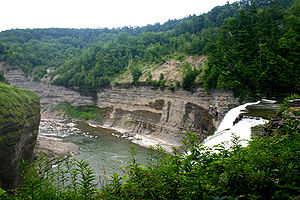
Middle Genesee
The first image shows the evidence of the glacial rerouting for the middle section of the Genesee. The original river had two branches. The east branch runs southeast of Mount Morris. It was much larger than the west branch, flowing from near present day Canisteo, New YorkCanisteo, New York
Canisteo may refer to two municipalities in Steuben County, New York in the United States:*Canisteo , New York*Canisteo , New York, located entirely within the town...
to empty into the preglacial Ontario River (now lake) north of Rochester. The headwaters of the east branch were blocked and diverted southward into the present Susquehanna River
Susquehanna River
The Susquehanna River is a river located in the northeastern United States. At long, it is the longest river on the American east coast that drains into the Atlantic Ocean, and with its watershed it is the 16th largest river in the United States, and the longest river in the continental United...
system by huge glacial terminal moraine
Moraine
A moraine is any glacially formed accumulation of unconsolidated glacial debris which can occur in currently glaciated and formerly glaciated regions, such as those areas acted upon by a past glacial maximum. This debris may have been plucked off a valley floor as a glacier advanced or it may have...
s just south of Dansville
Dansville, New York
Dansville, New York may refer to:* Dansville, Livingston County, New York* Dansville, Steuben County, New York...
. The entire old valley was buried in that area. This left only the small Canaseraga Creek, to flow in the remnant of the large ancient east branch valley from Dansville to Mount Morris.
The current upper Genesee (above Mount Morris) was only the west branch in preglacial times, a tributary river to the original. This branch, which entered the old valley was also dammed in the Nunda
Nunda, New York
Nunda, New York may refer to either the town or the village in the U.S. state of New York:* Nunda , New York* Nunda , New York...
area by moraines. A lake was formed with varve
Varve
A varve is an annual layer of sediment or sedimentary rock.The word 'varve' is derived from the Swedish word varv whose meanings and connotations include 'revolution', 'in layers', and 'circle'. The term first appeared as Hvarfig lera on the first map produced by the Geological Survey of Sweden in...
clay
Clay
Clay is a general term including many combinations of one or more clay minerals with traces of metal oxides and organic matter. Geologic clay deposits are mostly composed of phyllosilicate minerals containing variable amounts of water trapped in the mineral structure.- Formation :Clay minerals...
sediments visible along the valley sides in many spots, but the lake drained as the river found a way to cut a new valley northeastward from Portageville
Portageville, New York
Portageville is a hamlet located in the town of Genesee Falls in Wyoming County, New York, United States. Its name derives from the Native American canoists who would withdraw their craft from the river to avoid going over three waterfalls in the Genesee River gorge...
a little west of the original valley, then drop back into the old valley at Mount Morris. This section of new valley is a spectacular gorge with three scenic waterfall
Waterfall
A waterfall is a place where flowing water rapidly drops in elevation as it flows over a steep region or a cliff.-Formation:Waterfalls are commonly formed when a river is young. At these times the channel is often narrow and deep. When the river courses over resistant bedrock, erosion happens...
s, that is now the site of Letchworth State Park
Letchworth State Park
Letchworth State Park is a New York state park located 35 miles southwest of Rochester and 60 miles southeast of Buffalo in Livingston and Wyoming counties. The park is roughly 17 miles long, covering of land along the Genesee River...
.
Portions of other preglacial valleys can be seen both east and west of the Genesee, occupied now by lake
Lake
A lake is a body of relatively still fresh or salt water of considerable size, localized in a basin, that is surrounded by land. Lakes are inland and not part of the ocean and therefore are distinct from lagoons, and are larger and deeper than ponds. Lakes can be contrasted with rivers or streams,...
s. The remnants of these valleys were buried by glacial drift. A drumlin
Drumlin
A drumlin, from the Irish word droimnín , first recorded in 1833, is an elongated whale-shaped hill formed by glacial ice acting on underlying unconsolidated till or ground moraine.-Drumlin formation:...
field can be seen just north of Conesus and Hemlock Lakes
Finger Lakes
The Finger Lakes are a pattern of lakes in the west-central section of Upstate New York in the United States. They are a popular tourist destination. The lakes are long and thin , each oriented roughly on a north-south axis. The two longest, Cayuga Lake and Seneca Lake, are among the deepest in...
.