
Georgia State Route 100
Encyclopedia
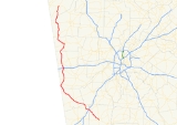
Georgia State Route 100 begins at the intersection of U.S. Route 27 and Georgia State Routes 18, 41 and 109 in Greenville in Meriwether County in west-central Georgia
. Moving north, SR 100 joins SR 54
just east of the interchange
with Interstate 85
east of Hogansville
. Once in Hogansville, SR 100 turns north co-signed with U.S. Route 29
/Georgia State Route 14
for a short distance before continuing northwest alone. Southeast of Franklin, Georgia
, SR 100 joins U.S. Route 27
/Georgia State Route 1. Just west of Franklin, SR 100, along with SR 34
, splits from U.S. 27 and continue west. In less than a mile, SR 100 splits from SR 34 and continues northwest. SR 100 continues north and becomes co-signed with SR 5
for a short time east of the Georgia/Alabama
state line before continuing north. As SR 100 moves toward Tallapoosa
, it crosses Interstate 20
where it is the first eastbound exit in Georgia. Crossing U.S. Route 78
in Tallapoosa, SR 100 becomes co-signed with U.S. Route 27 south of Cedartown, Georgia
. South of Cedartown, SR 100 turns west following U.S. Route 278
for a brief time before resuming a northwestern path. In Cave Spring, Georgia
, SR 100 turns west for a brief distance co-signed with U.S. Route 411
before turning north once again. SR 100 turns west co-signed with Georgia State Route 20
for a short distance before resuming its northern course toward Summerville
. SR 100 ends at the intersection of also U.S. Route 27 and Georgia State Route 114 in Summerville in Chattooga County
in northwest Georgia.
Georgia (U.S. state)
Georgia is a state located in the southeastern United States. It was established in 1732, the last of the original Thirteen Colonies. The state is named after King George II of Great Britain. Georgia was the fourth state to ratify the United States Constitution, on January 2, 1788...
. Moving north, SR 100 joins SR 54
Georgia State Route 54
State Route 54 starts at US 27/SR 1 in Troup County and ends in southwest Atlanta, as University Avenue, at the Downtown Connector .In Clayton County, SR 54 passes by Southlake Mall , a shopping mall....
just east of the interchange
Interchange (road)
In the field of road transport, an interchange is a road junction that typically uses grade separation, and one or more ramps, to permit traffic on at least one highway to pass through the junction without directly crossing any other traffic stream. It differs from a standard intersection, at which...
with Interstate 85
Interstate 85
Interstate 85 is a major interstate highway in the Southeastern United States. Its current southern terminus is at an interchange with Interstate 65 in Montgomery, Alabama; its northern terminus interchanges with Interstate 95 in Petersburg, Virginia, near Richmond...
east of Hogansville
Hogansville, Georgia
Hogansville is a city in Troup County, Georgia, United States. The population was 2,774 at the 2000 census. Hogansville holds an annual Hummingbird Festival in October...
. Once in Hogansville, SR 100 turns north co-signed with U.S. Route 29
U.S. Route 29
U.S. Route 29 is a north–south United States highway that runs for from the western suburbs of Baltimore, Maryland, to Pensacola, Florida. This highway's northern terminus is at Maryland Route 99 in Ellicott City, Maryland...
/Georgia State Route 14
Georgia State Route 14
State Route 14 begins in West Point and ends at Spring Street in southwest Atlanta. It overlaps U.S. 29 for its entire length, except for its last mile in Downtown Atlanta .In south Fulton County, S.R. 14 has a spur route State Route 14 begins in West Point (Troup County) and ends at Spring Street...
for a short distance before continuing northwest alone. Southeast of Franklin, Georgia
Franklin, Georgia
Note: a former Franklin, Georgia is now West Point, Georgia.----Franklin is a city in Heard County, Georgia, United States. The population was 902 at the 2000 census. The city is the county seat of Heard County...
, SR 100 joins U.S. Route 27
U.S. Route 27
U.S. Route 27 is a north–south United States highway in the southern and midwestern United States. The southern terminus is at US 1 in Miami, Florida. The northern terminus is at Interstate 69 in Fort Wayne, Indiana...
/Georgia State Route 1. Just west of Franklin, SR 100, along with SR 34
Georgia State Route 34
State Route 34 begins just west of Franklin at the Georgia–Alabama line and ends at the junction with SR 54 in eastern Coweta County, just west of Peachtree City. The portion extending east from Newnan is a four-lane parkway. Its bypass is Georgia State Route 34 Bypass...
, splits from U.S. 27 and continue west. In less than a mile, SR 100 splits from SR 34 and continues northwest. SR 100 continues north and becomes co-signed with SR 5
Georgia State Route 5
State Route 5 is a route that bisects northern Georgia. It passes through the county seats of Blue Ridge, Ellijay, Jasper, Canton, Marietta, and Douglasville. Along the way, it overlaps one of metro Atlanta's freeways, I-575. From the Cherokee/Pickens County line to Blue Ridge, Georgia 5 is...
for a short time east of the Georgia/Alabama
Alabama
Alabama is a state located in the southeastern region of the United States. It is bordered by Tennessee to the north, Georgia to the east, Florida and the Gulf of Mexico to the south, and Mississippi to the west. Alabama ranks 30th in total land area and ranks second in the size of its inland...
state line before continuing north. As SR 100 moves toward Tallapoosa
Tallapoosa, Georgia
Tallapoosa is a city in Haralson County, Georgia, United States. The population was 2,789 at the 2000 census.-Geography:Tallapoosa, incorporated in 1860, is located in Haralson County, in northwest Georgia, about west of Atlanta, just north of Interstate 20 and east of the Alabama state line...
, it crosses Interstate 20
Interstate 20 in Georgia
In Georgia, Interstate 20 runs from the Alabama border to the Savannah River, which the Georgia-South Carolina border straddles. It passes through the heavily congested Atlanta metropolitan area and exits the state at Augusta...
where it is the first eastbound exit in Georgia. Crossing U.S. Route 78
U.S. Route 78
U.S. Highway 78 is an east–west United States highway that runs for 715 miles from Memphis, Tennessee, to Charleston, South Carolina. Between Memphis and Birmingham, Alabama, it is being upgraded to become Interstate 22....
in Tallapoosa, SR 100 becomes co-signed with U.S. Route 27 south of Cedartown, Georgia
Cedartown, Georgia
Cedartown is a city in Polk County, Georgia, United States. As of the 2010 census, the city had a population of 9,750. The city is the county seat of Polk County...
. South of Cedartown, SR 100 turns west following U.S. Route 278
U.S. Route 278
U.S. Route 278 is a parallel route of U.S. Route 78. It currently runs for 1,074 miles from Hilton Head Island, South Carolina to Wickes, Arkansas at U.S. Highway 71/U.S. Highway 59. It might be notable that it is longer than its parent highway, US Hwy-78. US Hwy-278 passes through the states of...
for a brief time before resuming a northwestern path. In Cave Spring, Georgia
Cave Spring, Georgia
Cave Spring is a city in Floyd County, Georgia, United States. It is located south of Rome, Georgia. The population was 975 at the 2000 census. It is part of the 'Rome, Georgia Metropolitan Statistical Area'. The name of town was named after its cave and water spring hence "Cave Spring". The...
, SR 100 turns west for a brief distance co-signed with U.S. Route 411
U.S. Route 411
U.S. Highway 411 is an alternate parallel-highway associated with U.S. Highway 11. U.S. 411 extends for about 313 miles from U.S. Route 78 in Leeds, Jefferson County, Alabama, to U.S. Highway 25 in Newport, Cocke County, Tennessee. U.S. 411 passes through the northeastern State of Alabama, the...
before turning north once again. SR 100 turns west co-signed with Georgia State Route 20
Georgia State Route 20
State Route 20 is an abnormally-oriented route in roughly the shape of a capital J rotated ninety degrees to the left. Its counterclockwise terminus is at the Alabama state line in Floyd County, and its clockwise terminus occurs in the middle of an overpass over US 19/US 41 and SR 3 in Hampton in...
for a short distance before resuming its northern course toward Summerville
Summerville, Georgia
Summerville is a city in Chattooga County, Georgia, United States. The population was 4,556 at the 2000 census. The city is the county seat of Chattooga County.- Geography :Summerville is located at ....
. SR 100 ends at the intersection of also U.S. Route 27 and Georgia State Route 114 in Summerville in Chattooga County
Chattooga County, Georgia
Chattooga County is a county located in the U.S. state of Georgia. It was created on December 28, 1838. As of 2000, the population was 25,470. The 2007 Census Estimate shows a population of 26,797. The county seat is Summerville.-Geography:...
in northwest Georgia.