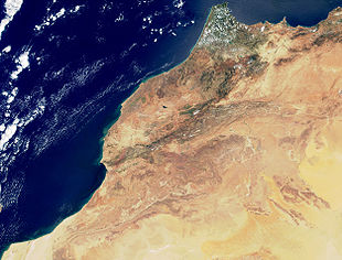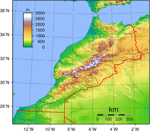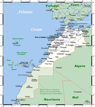
Geography of Morocco
Encyclopedia


Atlantic Ocean
The Atlantic Ocean is the second-largest of the world's oceanic divisions. With a total area of about , it covers approximately 20% of the Earth's surface and about 26% of its water surface area...
, to mountainous areas, to the Sahara
Sahara
The Sahara is the world's second largest desert, after Antarctica. At over , it covers most of Northern Africa, making it almost as large as Europe or the United States. The Sahara stretches from the Red Sea, including parts of the Mediterranean coasts, to the outskirts of the Atlantic Ocean...
(desert). Morocco
Morocco
Morocco , officially the Kingdom of Morocco , is a country located in North Africa. It has a population of more than 32 million and an area of 710,850 km², and also primarily administers the disputed region of the Western Sahara...
is a Northern African country, bordering the North Atlantic Ocean and the Mediterranean Sea
Mediterranean Sea
The Mediterranean Sea is a sea connected to the Atlantic Ocean surrounded by the Mediterranean region and almost completely enclosed by land: on the north by Anatolia and Europe, on the south by North Africa, and on the east by the Levant...
.
A large part of Morocco
Morocco
Morocco , officially the Kingdom of Morocco , is a country located in North Africa. It has a population of more than 32 million and an area of 710,850 km², and also primarily administers the disputed region of the Western Sahara...
is mountainous. The Atlas Mountains
Atlas Mountains
The Atlas Mountains is a mountain range across a northern stretch of Africa extending about through Morocco, Algeria, and Tunisia. The highest peak is Toubkal, with an elevation of in southwestern Morocco. The Atlas ranges separate the Mediterranean and Atlantic coastlines from the Sahara Desert...
are located mainly in the center and the south of the country. The Rif Mountains are located in the north of the country. Both ranges are mainly inhabited by the Berber people
Berber people
Berbers are the indigenous peoples of North Africa west of the Nile Valley. They are continuously distributed from the Atlantic to the Siwa oasis, in Egypt, and from the Mediterranean to the Niger River. Historically they spoke the Berber language or varieties of it, which together form a branch...
.
Geography statistics
Coordinates:
32°00′N 5°00′W
Map references:
Africa
Area:
total:
446,550 km²
land:
446,550 km²
water:
250 km²
Area - comparative:
slightly larger than California
California
California is a state located on the West Coast of the United States. It is by far the most populous U.S. state, and the third-largest by land area...
Land boundaries:
total:
2 017.9 km
border countries:
Algeria
Algeria
Algeria , officially the People's Democratic Republic of Algeria , also formally referred to as the Democratic and Popular Republic of Algeria, is a country in the Maghreb region of Northwest Africa with Algiers as its capital.In terms of land area, it is the largest country in Africa and the Arab...
1 559 km, Mauritania
Mauritania
Mauritania is a country in the Maghreb and West Africa. It is bordered by the Atlantic Ocean in the west, by Western Sahara in the north, by Algeria in the northeast, by Mali in the east and southeast, and by Senegal in the southwest...
1561 km, Spain
Spain
Spain , officially the Kingdom of Spain languages]] under the European Charter for Regional or Minority Languages. In each of these, Spain's official name is as follows:;;;;;;), is a country and member state of the European Union located in southwestern Europe on the Iberian Peninsula...
(Ceuta
Ceuta
Ceuta is an autonomous city of Spain and an exclave located on the north coast of North Africa surrounded by Morocco. Separated from the Iberian peninsula by the Strait of Gibraltar, Ceuta lies on the border of the Mediterranean Sea and the Atlantic Ocean. Ceuta along with the other Spanish...
) 6.3 km, Spain (Melilla
Melilla
Melilla is a autonomous city of Spain and an exclave on the north coast of Morocco. Melilla, along with the Spanish exclave Ceuta, is one of the two Spanish territories located in mainland Africa...
) 9.6 km
Coastline:
1 835 km
Maritime claims:
contiguous zone:
24 nmi (44.4 km; 27.6 mi)
continental shelf:
200-m depth or to the depth of exploitation
exclusive economic zone:
200 nmi (370.4 km; 230.2 mi)
territorial sea:
12 nmi (22.2 km; 13.8 mi)
Physical geography
Mediterranean, becoming more extreme in the interiorTerrain:
northern coast and interior are mountainous with large areas of bordering plateaus, intermontane valleys, and rich coastal plains
Geography - note:
strategic location along Strait of Gibraltar
Strait of Gibraltar
The Strait of Gibraltar is a narrow strait that connects the Atlantic Ocean to the Mediterranean Sea and separates Spain in Europe from Morocco in Africa. The name comes from Gibraltar, which in turn originates from the Arabic Jebel Tariq , albeit the Arab name for the Strait is Bab el-Zakat or...
Elevation extremes:
lowest point:
Sebkha Tah -55 m
highest point:
Jbel Toubkal 4165 m
Land use and natural resources
Natural resources:phosphates, iron
Iron
Iron is a chemical element with the symbol Fe and atomic number 26. It is a metal in the first transition series. It is the most common element forming the planet Earth as a whole, forming much of Earth's outer and inner core. It is the fourth most common element in the Earth's crust...
ore, manganese
Manganese
Manganese is a chemical element, designated by the symbol Mn. It has the atomic number 25. It is found as a free element in nature , and in many minerals...
, lead
Lead
Lead is a main-group element in the carbon group with the symbol Pb and atomic number 82. Lead is a soft, malleable poor metal. It is also counted as one of the heavy metals. Metallic lead has a bluish-white color after being freshly cut, but it soon tarnishes to a dull grayish color when exposed...
, zinc
Zinc
Zinc , or spelter , is a metallic chemical element; it has the symbol Zn and atomic number 30. It is the first element in group 12 of the periodic table. Zinc is, in some respects, chemically similar to magnesium, because its ion is of similar size and its only common oxidation state is +2...
, fish
Fish
Fish are a paraphyletic group of organisms that consist of all gill-bearing aquatic vertebrate animals that lack limbs with digits. Included in this definition are the living hagfish, lampreys, and cartilaginous and bony fish, as well as various extinct related groups...
, salt
Salt
In chemistry, salts are ionic compounds that result from the neutralization reaction of an acid and a base. They are composed of cations and anions so that the product is electrically neutral...
Land use:
arable land:
21%
permanent crops:
1%
permanent pastures:
47%
forests and woodland:
20%
other:
11% (1993 est.)
Irrigated land:
12 580 km² (1993 est.)
Natural hazards:
northern mountains geologically unstable and subject to earthquakes; periodic droughts
Mediterranean forests, woodlands, and scrubMediterranean forests, woodlands, and scrubMediterranean forests, woodlands, and scrub biome, defined by the World Wildlife Fund, characterized by dry summers and rainy winters. Summers are typically hot in low-lying inland locations but can be cool near some seas, as near San Francisco, which have a sea of cool waters...
- Mediterranean dry woodlands and steppeMediterranean dry woodlands and steppeThe Mediterranean dry woodlands and steppe is a Mediterranean forests, woodlands, and scrub ecoregion of North Africa. It occupies interior plateaus and mountain ranges of the Maghreb region, lying generally between the coastal Mediterranean woodlands and forests to the north and the Sahara to the...
- Mediterranean woodlands and forestsMediterranean woodlands and forestsThe Mediterranean woodlands and forests is an ecoregion, of the Mediterranean forests, woodlands, and scrub Biome, in the coastal plains, hills, and mountains bordering the Mediterranean Sea and Atlantic Ocean in North Africa.-Geography:...
- Mediterranean acacia-argania dry woodlands and succulent thickets
Current environmental issues
Land degradation/desertification (soil erosion resulting from farming of marginal areas, overgrazing, destruction of vegetation); water supplies contaminated by raw sewage; siltation of reservoirs; oil pollution of coastal watersInternational environmental agreements
Morocco is party to:Biodiversity
Biodiversity
Biodiversity is the degree of variation of life forms within a given ecosystem, biome, or an entire planet. Biodiversity is a measure of the health of ecosystems. Biodiversity is in part a function of climate. In terrestrial habitats, tropical regions are typically rich whereas polar regions...
, Climate Change
United Nations Framework Convention on Climate Change
The United Nations Framework Convention on Climate Change is an international environmental treaty produced at the United Nations Conference on Environment and Development , informally known as the Earth Summit, held in Rio de Janeiro from June 3 to 14, 1992...
, Desertification
Desertification
Desertification is the degradation of land in drylands. Caused by a variety of factors, such as climate change and human activities, desertification is one of the most significant global environmental problems.-Definitions:...
, Endangered Species
Endangered species
An endangered species is a population of organisms which is at risk of becoming extinct because it is either few in numbers, or threatened by changing environmental or predation parameters...
, Hazardous Wastes, Marine Dumping, Nuclear Test Ban, Ozone Layer Protection, Ship Pollution (MARPOL 73/78
MARPOL 73/78
Marpol 73/78 is the International Convention for the Prevention of Pollution From Ships, 1973 as modified by the Protocol of 1978....
), Wetlands
signed, but not ratified:
Environmental Modification, Law of the Sea
Law of the sea
Law of the sea may refer to:* United Nations Convention on the Law of the Sea* Admiralty law* The Custom of the Sea...
Extreme points
This is a list of the extreme points of MoroccoMorocco
Morocco , officially the Kingdom of Morocco , is a country located in North Africa. It has a population of more than 32 million and an area of 710,850 km², and also primarily administers the disputed region of the Western Sahara...
, the points that are farther north, south, east or west than any other location (excluding the disputed estern Sahara] area]).
- Northern-most point – Punta Cires, Tangier-TétouanTangier-TetouanTangier-Tetouan is one of the sixteen regions of Morocco. It is situated in north-western Morocco. It covers an area of 11,570 km² and has a population of 2,470,372...
region - Eastern-most point – unnamed point on the border with AlgeriaAlgeriaAlgeria , officially the People's Democratic Republic of Algeria , also formally referred to as the Democratic and Popular Republic of Algeria, is a country in the Maghreb region of Northwest Africa with Algiers as its capital.In terms of land area, it is the largest country in Africa and the Arab...
immediately east of the town of Iche, Oriental region - Southern-most point – the border with Western SaharaWestern SaharaWestern Sahara is a disputed territory in North Africa, bordered by Morocco to the north, Algeria to the northeast, Mauritania to the east and south, and the Atlantic Ocean to the west. Its surface area amounts to . It is one of the most sparsely populated territories in the world, mainly...
, Guelmim-Es SemaraGuelmim-Es SemaraGuelmim-Es Semara is one of the sixteen regions of Morocco. It covers an area of 122,825 km² and has a population of 462,410 . The capital is Guelmim. The southern half of the region forms part of the Western Sahara....
region* - Western-most point - the point at which the border with Western SaharaWestern SaharaWestern Sahara is a disputed territory in North Africa, bordered by Morocco to the north, Algeria to the northeast, Mauritania to the east and south, and the Atlantic Ocean to the west. Its surface area amounts to . It is one of the most sparsely populated territories in the world, mainly...
enters the Atlantic OceanAtlantic OceanThe Atlantic Ocean is the second-largest of the world's oceanic divisions. With a total area of about , it covers approximately 20% of the Earth's surface and about 26% of its water surface area...
, Guelmim-Es SemaraGuelmim-Es SemaraGuelmim-Es Semara is one of the sixteen regions of Morocco. It covers an area of 122,825 km² and has a population of 462,410 . The capital is Guelmim. The southern half of the region forms part of the Western Sahara....
region
- *Note: Morocco does not have a southern-most point, the border being formed by a straight horizontal line
External links
- European Digital Archive on the Soil Maps of the world Soil Maps of Morocco

