

Geography of Kyrgyzstan
Encyclopedia
Kyrgyzstan
is a landlocked nation in Central Asia
, west of the People's Republic of China
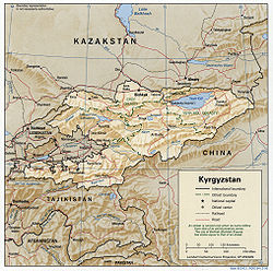
. Less than a seventh the size of Mongolia, at 199,951 square kilometers, Kyrgyzstan is one of the smaller Central Asian states. The national territory extends about 900 kilometers from east to west and 410 kilometers from north to south.
Kyrgyzstan is bordered on the east and southeast by China, on the north by Kazakhstan
, on the west by Uzbekistan
and on the south by Tajikistan
. The borders with Uzbekistan and Tadjikistan in the Ferghana valley are rather difficult. One consequence of the Stalinist division of Central Asia into five republics is that many ethnic Kyrgyz do not live in Kyrgyzstan. Three enclaves, legally part of the territory of Kyrgyzstan but geographically removed by several kilometers, have been established, two in Uzbekistan and one in Tajikistan.
The terrain of Kyrgyzstan is dominated by the Tian Shan and Pamir mountain systems, which together occupy about 65 % of the national territory. The Alay range
portion of the Tian Shan
system dominates the southwestern crescent of the country, and, to the east, the main Tian Shan range runs along the boundary between southern Kyrgyzstan and China before extending farther east into China's Xinjiang Uygur Autonomous Region
. Kyrgyzstan's average elevation is 2,750 meters, ranging from 7,439 meters at Peak Jengish Chokusu to 394 meters in the Fergana Valley
near Osh
. Almost 90 % of the country lies more than 1,500 meters above sea level.

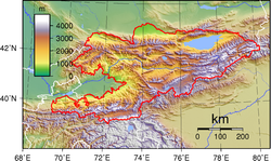 The mountains of Kyrgyzstan are geologically young, so that the physical terrain is marked by sharply uplifted peaks separated by deep valleys. There is also considerable glaciation. Kyrgyzstan's 6,500 distinct glaciers are estimated to hold about 650 cubic kilometers of water. Only around the Chui, Talas, and Fergana valleys is there relatively flat land suitable for large-scale agriculture.
Because the high peaks function as moisture catchers, Kyrgyzstan is relatively well watered by the streams that descend from them. None of the rivers of Kyrgyzstan are navigable, however. The majority are small, rapid, runoff streams. Most of Kyrgyzstan's rivers are tributaries of the Syrdariya, which has its headwaters in the western Tian Shan along the Chinese border. Another large runoff system forms the Chui River, which arises in northern Kyrgyzstan, then flows northwest and disappears into the deserts of southern Kazakhstan. Ysyk-Köl
is the second largest body of water in Central Asia, after the Aral Sea
, but the saline lake has been shrinking steadily, and its mineral content has been rising gradually. Kyrgyzstan has a total of about 2,000 lakes with a total surface area of 7,000 km², mostly located at altitudes of 3,000 to 4,000 meters. Only the largest three, however, occupy more than 100 km² each. The second- and third-largest lakes, Songköl
and Chatyr-Köl
(the latter of which also is saline), are located in the Naryn River Basin
.
Natural disasters have been frequent and varied. Overgrazing and deforestation of steep mountain slopes have increased the occurrence of mudslides and avalanches, which occasionally have swallowed entire villages. In August 1992, a severe earthquake left several thousand people homeless in the southwestern city of Jalal-Abad
.
Natural hazards: prone to earthquakes, major flooding during the snow melt.
 Although Kyrgyzstan has abundant water running through it, its water supply is determined by a post-Soviet sharing agreement among the five Central Asian republics. As in the Soviet era, Kyrgyzstan has the right to 25 % of the water that originates in its territory, but the new agreement allows Turkmenistan and Uzbekistan unlimited use of the water that flows into them from Kyrgyzstan, with no compensation for the nation at the source. Kyrgyzstan uses the entire amount to which the agreement entitles it, but utilization is skewed heavily in favor of agricultural irrigation. In 1994 agriculture accounted for about 88 % of total water consumption, compared with 8 % by industry and 4 % by municipal water distribution systems. According to World Bank experts, Kyrgyzstan has an adequate supply of high-quality water for future use, provided the resource is prudently managed.
Irrigation is extremely wasteful of water because the distribution infrastructure is old and poorly maintained. In 1993 only an estimated 5 % of required maintenance expenditures was allocated. Overall, an estimated 70 % of the nation's water supply network is in need of repair or replacement. The quality of drinking water from this aging system is poorly monitored—the water management staff has been cut drastically because of inadequate funds. Further, there is no money to buy new water disinfection equipment when it is needed. Some aquifers near industrial and mining centers have been contaminated by heavy metals, oils, and sanitary wastes. In addition, many localities rely on surface sources, making users vulnerable to agricultural runoff and livestock waste, which seep gradually downward from the surface. The areas of lowest water quality are the heavily populated regions of the Chui Valley and Osh
and Jalal-Abad
provinces, and areas along the rivers flowing into Ysyk-Köl.
In towns, wastewater collection provides about 70 % of the water supply. Although towns have biological treatment equipment, as much as 50 % of such equipment is rated as ineffective. The major sources of toxic waste in the water supply are the mercury
mining combine at Haidarkan; the antimony
mine at Kadamzai; the Kadzyi Sai uranium
mine, which ceased extraction in 1967 but which continues to leach toxic materials into nearby Ysyk Köl; the Kara-Balta Uranium
Recovery Plant; the Min Kush deposit of mine tailings; and the Kyrgyz Mining and Metallurgy Plant at Orlovka.
 The most important problems in land use are soil erosion and salinization in improperly irrigated farmland. An estimated 60 % of Kyrgyzstan's land is affected by topsoil loss, and 6 % by salinization, both problems with more serious long-term than short-term effects. In 1994 the size of livestock herds averaged twice the carrying capacity of pasturage land, continuing the serious overgrazing problem and consequent soil erosion that began when the herds were at their peak in the late 1980s. Uncertain land tenure and overall financial insecurity have caused many private farmers to concentrate their capital in the traditional form—livestock—thus subjecting new land to the overgrazing problem.
The inherent land shortage in Kyrgyzstan is exacerbated by the flooding of agricultural areas for hydroelectric projects. The creation of Toktogul
Reservoir on the Naryn River, for example, involved the flooding of 130 km² of fertile land. Such projects have the additional effect of constricting downstream water supply; Toktogul deprives the lower reaches of the Syr Darya in Uzbekistan and the Aral Sea Basin of substantial amounts of water. Because the Naryn Basin, where many hydroelectric projects are located, is very active seismically, flooding is also a danger should a dam be broken by an earthquake. Several plants are now in operation in zones where Richter Scale readings may reach eleven.
Environment - current issues: Nuclear waste, left behind by the Soviet Union in many open-air pits in hazardous locations. Water pollution
; many people get their water directly from contaminated streams and wells; as a result, water-borne diseases are prevalent; increasing soil salinity from faulty irrigation practices. Illegal hunting of very rare species such as the snow leopard
and the Marco Polo sheep
.
Environment - international agreements:
party to: Biodiversity
, Desertification
, Hazardous Wastes
signed, but not ratified: none of the selected agreements
, the five states sharing the Aral Sea Basin (Kazakhstan, Kyrgyzstan, Tajikistan, Turkmenistan, and Uzbekistan) are developing a strategy to end the crisis. The World Bank and agencies of the United Nations (UN) have developed an Aral Sea Program, the first stage of which is funded by the five countries and external donors. That stage has seven areas of focus, one of which—land and water management in the upper watersheds—is of primary concern to Kyrgyzstan. Among the conditions detrimental to the Aral Sea's environment are erosion from deforestation and overgrazing, contamination from poorly managed irrigation systems, and uncontrolled waste from mining and municipal effluents. Kyrgyzstan's National Environmental Action Plan (NEAP) has addressed these problems as part of its first-phase priorities in cooperation with the Aral Sea Program.
 The NEAP, adopted in 1994, is the basic blueprint for environmental protection. The plan focuses on solving a small number of critical problems, collecting reliable information to aid in that process, and integrating environmental measures with economic and social development strategy. The initial planning period is to end in 1997. The main targets of that phase are inefficient water resource management, land degradation, overexploitation
of forest reserves, loss of biodiversity
, and pollution from inefficient mining and refining practices.
Because of severe budget constraints, most of the funds for NEAP operations come from international sources, including official institutions such as the World Bank and the Asian Development Bank and numerous international nongovernmental organizations. Implementation is guided by a committee of state ministers and by a NEAP Expert Working Group, both established in 1994 by executive order. A NEAP office in Bishkek was set up with funds from Switzerland.
The main environmental protection agency of the Kyrgyzstan government is the State Committee on Environmental Protection, still known by its Soviet-era acronym, Goskompriroda. Established by the old regime in 1988, the agency's post-Soviet responsibilities have been described in a series of decrees beginning in 1991. In 1994 the state committee had a central office in Bishkek, one branch in each of the seven provinces, and a total staff of about 150 persons. Because of poorly defined lines of responsibility, administrative conflicts often occur between local and national authorities of Goskompriroda and between Goskompriroda and a second national agency, the Hydrometeorological Administration (Gidromet), which is the main monitoring agency for air, water, and soil quality. In general, the vertical hierarchy structure, a relic of Soviet times, has led to poor coordination and duplication of effort among environmental protection agencies.
 Area:
Area:
total: 198,500 km²
land: 191,300 km²
water: 7,200 km²
Land boundaries:
total: 3,878 km
border countries: the People's Republic of China
858 km, Kazakhstan
1,051 km, Tajikistan
870 km, Uzbekistan
1,099 km
Coastline: 0 km (landlocked)
Maritime claims: none (landlocked)
Elevation extremes:
lowest point: Kara-Darya 132 m
highest point: Peak Jengish Chokusu 7,439 m
 Natural resources: abundant hydropower
; significant deposits of gold
and rare earth metals; locally exploitable coal
, petroleum
, and natural gas
; other deposits of nepheline
, mercury
, bismuth
, lead
, and zinc
.
Land use:
arable land: 7%
permanent crops: 0%
permanent pastures: 44%
forests and woodland: 4%
other: 45% (1993 est.)
note:
Kyrgyzstan has the world's largest natural growth walnut
forest, Arslanbob
, located in Jalal-Abad Province
with an enormous variety of different genetic characteristics. It is believed that most of the world's walnut varieties derive from the original species still found here.
Irrigated land: 9,000 km² (1993 est.)
Kyrgyzstan
Kyrgyzstan , officially the Kyrgyz Republic is one of the world's six independent Turkic states . Located in Central Asia, landlocked and mountainous, Kyrgyzstan is bordered by Kazakhstan to the north, Uzbekistan to the west, Tajikistan to the southwest and China to the east...
is a landlocked nation in Central Asia
Central Asia
Central Asia is a core region of the Asian continent from the Caspian Sea in the west, China in the east, Afghanistan in the south, and Russia in the north...
, west of the People's Republic of China
People's Republic of China
China , officially the People's Republic of China , is the most populous country in the world, with over 1.3 billion citizens. Located in East Asia, the country covers approximately 9.6 million square kilometres...
. Less than a seventh the size of Mongolia, at 199,951 square kilometers, Kyrgyzstan is one of the smaller Central Asian states. The national territory extends about 900 kilometers from east to west and 410 kilometers from north to south.
Kyrgyzstan is bordered on the east and southeast by China, on the north by Kazakhstan
Kazakhstan
Kazakhstan , officially the Republic of Kazakhstan, is a transcontinental country in Central Asia and Eastern Europe. Ranked as the ninth largest country in the world, it is also the world's largest landlocked country; its territory of is greater than Western Europe...
, on the west by Uzbekistan
Uzbekistan
Uzbekistan , officially the Republic of Uzbekistan is a doubly landlocked country in Central Asia and one of the six independent Turkic states. It shares borders with Kazakhstan to the west and to the north, Kyrgyzstan and Tajikistan to the east, and Afghanistan and Turkmenistan to the south....
and on the south by Tajikistan
Tajikistan
Tajikistan , officially the Republic of Tajikistan , is a mountainous landlocked country in Central Asia. Afghanistan borders it to the south, Uzbekistan to the west, Kyrgyzstan to the north, and China to the east....
. The borders with Uzbekistan and Tadjikistan in the Ferghana valley are rather difficult. One consequence of the Stalinist division of Central Asia into five republics is that many ethnic Kyrgyz do not live in Kyrgyzstan. Three enclaves, legally part of the territory of Kyrgyzstan but geographically removed by several kilometers, have been established, two in Uzbekistan and one in Tajikistan.
The terrain of Kyrgyzstan is dominated by the Tian Shan and Pamir mountain systems, which together occupy about 65 % of the national territory. The Alay range
Alay Mountains
The Alay or Alai Mountains is a mountain range that extends from the Tien Shan mountain range in Kyrgyzstan west into Tajikistan. It is part of the Pamir-Alay mountain system. The range runs approximately east to west. Its highest summit is Pik Tandykul , 5544 m. The southern slopes of the range...
portion of the Tian Shan
Tian Shan
The Tian Shan , also spelled Tien Shan, is a large mountain system located in Central Asia. The highest peak in the Tian Shan is Victory Peak , ....
system dominates the southwestern crescent of the country, and, to the east, the main Tian Shan range runs along the boundary between southern Kyrgyzstan and China before extending farther east into China's Xinjiang Uygur Autonomous Region
Xinjiang
Xinjiang is an autonomous region of the People's Republic of China. It is the largest Chinese administrative division and spans over 1.6 million km2...
. Kyrgyzstan's average elevation is 2,750 meters, ranging from 7,439 meters at Peak Jengish Chokusu to 394 meters in the Fergana Valley
Fergana Valley
The Fergana Valley or Farghana Valley is a region in Central Asia spreading across eastern Uzbekistan, Kyrgyzstan and Tajikistan. Divided across three subdivisions of the former Soviet Union, the valley is ethnically diverse, and in the early 21st century was the scene of ethnic conflict...
near Osh
Osh
Osh is the second largest city in Kyrgyzstan, located in the Fergana Valley in the south of the country and often referred to as the "capital of the south". The city is at least 3,000 years old, and has served as the administrative center of Osh Province since 1939...
. Almost 90 % of the country lies more than 1,500 meters above sea level.
Topography and drainage
Because the high peaks function as moisture catchers, Kyrgyzstan is relatively well watered by the streams that descend from them. None of the rivers of Kyrgyzstan are navigable, however. The majority are small, rapid, runoff streams. Most of Kyrgyzstan's rivers are tributaries of the Syrdariya, which has its headwaters in the western Tian Shan along the Chinese border. Another large runoff system forms the Chui River, which arises in northern Kyrgyzstan, then flows northwest and disappears into the deserts of southern Kazakhstan. Ysyk-Köl
Issyk Kul
Issyk Kul is an endorheic lake in the northern Tian Shan mountains in eastern Kyrgyzstan. It is the tenth largest lake in the world by volume and the second largest saline lake after the Caspian Sea. Although it is surrounded by snow-capped peaks, it never freezes; hence its name, which means "hot...
is the second largest body of water in Central Asia, after the Aral Sea
Aral Sea
The Aral Sea was a lake that lay between Kazakhstan in the north and Karakalpakstan, an autonomous region of Uzbekistan, in the south...
, but the saline lake has been shrinking steadily, and its mineral content has been rising gradually. Kyrgyzstan has a total of about 2,000 lakes with a total surface area of 7,000 km², mostly located at altitudes of 3,000 to 4,000 meters. Only the largest three, however, occupy more than 100 km² each. The second- and third-largest lakes, Songköl
Son-Kul
Song Köl is an alpine lake in northern Naryn Province, Kyrgyzstan. It is the second largest lake in Kyrgyzstan after Issyk Kul Lake. Its name, meaning "following lake", is popularly considered to refer to this relation...
and Chatyr-Köl
Chatyr-Kul
Chatyr-Kul is an endorheic alpine lake in the Tian Shan mountains in At-Bashi District of Naryn Province, Kyrgyzstan; it lies in the lower part of Chatyr-Kul Depression near the Torugart Pass border crossing into China. The name of the lake means “Celestial Lake” in Kyrgyz...
(the latter of which also is saline), are located in the Naryn River Basin
Naryn River
The Naryn River rises in the Tian Shan mountains in Kyrgyzstan, Central Asia, flowing west through the Fergana Valley into Uzbekistan. Here it merges with the Kara Darya River to form the Syr Darya...
.
Natural disasters have been frequent and varied. Overgrazing and deforestation of steep mountain slopes have increased the occurrence of mudslides and avalanches, which occasionally have swallowed entire villages. In August 1992, a severe earthquake left several thousand people homeless in the southwestern city of Jalal-Abad
Jalal-Abad
Jalalabat is the administrative and economic centre of Jalal-Abad Province in southwestern Kyrgyzstan, with a population of about 150,000...
.
Climate
The country's climate is influenced chiefly by the mountains, Kyrgyzstan's position near the middle of the Eurasian landmass, and the absence of any body of water large enough to influence weather patterns. Those factors create a distinctly continental climate that has significant local variations. Although the mountains tend to collect clouds and block sunlight (reducing some narrow valleys at certain times of year to no more than three or four hours of sunlight per day), the country is generally sunny, receiving as much as 2,900 hours of sunlight per year in some areas. The same conditions also affect temperatures, which can vary significantly from place to place. In January the warmest average temperature (-4 °C) occurs around the southern city of Osh, and around Ysyk-Köl. The latter, which has a volume of 1738 cubic kilometres (417 cu mi), does not freeze in winter. Indeed, its name means "hot lake" in Kyrgyz. The coldest temperatures are in mountain valleys. There, readings can fall to -30 °C or lower; the record is -53.6 °C. The average temperature for July similarly varies from 27 °C (80.6 °F) in the Fergana Valley, where the record high is 44 °C (111.2 °F), to a low of -10 °C on the highest mountain peaks. Precipitation varies from 2000 millimetres (78.7 in) per year in the mountains above the Fergana Valley to less than 100 millimetres (3.9 in) per year on the west bank of Ysyk-Köl.Environmental issues
Kyrgyzstan has been spared many of the enormous environmental problems faced by its Central Asian neighbors, primarily because its designated roles in the Soviet system involved neither heavy industry nor large-scale cotton production. Also, the economic downturn of the early 1990s reduced some of the more serious effects of industrial and agricultural policy. Nevertheless, Kyrgyzstan has serious problems because of inefficient use and pollution of water resources, land degradation, and improper agricultural practices.Natural hazards: prone to earthquakes, major flooding during the snow melt.
Water resources
Irrigation is extremely wasteful of water because the distribution infrastructure is old and poorly maintained. In 1993 only an estimated 5 % of required maintenance expenditures was allocated. Overall, an estimated 70 % of the nation's water supply network is in need of repair or replacement. The quality of drinking water from this aging system is poorly monitored—the water management staff has been cut drastically because of inadequate funds. Further, there is no money to buy new water disinfection equipment when it is needed. Some aquifers near industrial and mining centers have been contaminated by heavy metals, oils, and sanitary wastes. In addition, many localities rely on surface sources, making users vulnerable to agricultural runoff and livestock waste, which seep gradually downward from the surface. The areas of lowest water quality are the heavily populated regions of the Chui Valley and Osh
Osh Province
Osh Province is a province of Kyrgyzstan. Its capital is Osh. It is bounded by Jalal-Abad Province, Naryn Province, Xinjiang, China, Tajikistan, Batken Province and Uzbekistan.-Geography:...
and Jalal-Abad
Jalal-Abad Province
Jalal-Abad Province, also known as Jalalabat , is a province of Kyrgyzstan. Its capital is the city of the same name, Jalal-Abad. It is surrounded by Talas Province, Chui Province, Naryn Province, Osh Province and Uzbekistan. The Jalal-Abad Province was established on November 21, 1939...
provinces, and areas along the rivers flowing into Ysyk-Köl.
In towns, wastewater collection provides about 70 % of the water supply. Although towns have biological treatment equipment, as much as 50 % of such equipment is rated as ineffective. The major sources of toxic waste in the water supply are the mercury
Mercury (element)
Mercury is a chemical element with the symbol Hg and atomic number 80. It is also known as quicksilver or hydrargyrum...
mining combine at Haidarkan; the antimony
Antimony
Antimony is a toxic chemical element with the symbol Sb and an atomic number of 51. A lustrous grey metalloid, it is found in nature mainly as the sulfide mineral stibnite...
mine at Kadamzai; the Kadzyi Sai uranium
Uranium
Uranium is a silvery-white metallic chemical element in the actinide series of the periodic table, with atomic number 92. It is assigned the chemical symbol U. A uranium atom has 92 protons and 92 electrons, of which 6 are valence electrons...
mine, which ceased extraction in 1967 but which continues to leach toxic materials into nearby Ysyk Köl; the Kara-Balta Uranium
Uranium
Uranium is a silvery-white metallic chemical element in the actinide series of the periodic table, with atomic number 92. It is assigned the chemical symbol U. A uranium atom has 92 protons and 92 electrons, of which 6 are valence electrons...
Recovery Plant; the Min Kush deposit of mine tailings; and the Kyrgyz Mining and Metallurgy Plant at Orlovka.
Land management
The inherent land shortage in Kyrgyzstan is exacerbated by the flooding of agricultural areas for hydroelectric projects. The creation of Toktogul
Toktogul
Toktogul is an urban-type settlement in the Jalal-Abad Province of Kyrgyzstan. There are an estimated 15,943 inhabitants. It is named after its most famous son - the musician Toktogul Satilganov. It is located on the northern shore of the Toktogul reservoir. To the south, highway M41 curves around...
Reservoir on the Naryn River, for example, involved the flooding of 130 km² of fertile land. Such projects have the additional effect of constricting downstream water supply; Toktogul deprives the lower reaches of the Syr Darya in Uzbekistan and the Aral Sea Basin of substantial amounts of water. Because the Naryn Basin, where many hydroelectric projects are located, is very active seismically, flooding is also a danger should a dam be broken by an earthquake. Several plants are now in operation in zones where Richter Scale readings may reach eleven.
Environment - current issues: Nuclear waste, left behind by the Soviet Union in many open-air pits in hazardous locations. Water pollution
Water pollution
Water pollution is the contamination of water bodies . Water pollution occurs when pollutants are discharged directly or indirectly into water bodies without adequate treatment to remove harmful compounds....
; many people get their water directly from contaminated streams and wells; as a result, water-borne diseases are prevalent; increasing soil salinity from faulty irrigation practices. Illegal hunting of very rare species such as the snow leopard
Snow Leopard
The snow leopard is a moderately large cat native to the mountain ranges of South Asia and Central Asia...
and the Marco Polo sheep
Marco Polo sheep
The Marco Polo sheep is a subspecies of argali sheep, named after Marco Polo. Their habitat is the mountainous regions of Central Asia. Marco Polo sheep are distinguishable mostly by their large size and spiraling horns. Their conservation status is "near threatened" and efforts have been made to...
.
Environment - international agreements:
party to: Biodiversity
Biodiversity
Biodiversity is the degree of variation of life forms within a given ecosystem, biome, or an entire planet. Biodiversity is a measure of the health of ecosystems. Biodiversity is in part a function of climate. In terrestrial habitats, tropical regions are typically rich whereas polar regions...
, Desertification
Desertification
Desertification is the degradation of land in drylands. Caused by a variety of factors, such as climate change and human activities, desertification is one of the most significant global environmental problems.-Definitions:...
, Hazardous Wastes
signed, but not ratified: none of the selected agreements
The Aral Sea
In response to the internationally recognized environmental crisis of the rapid desiccation of the Aral SeaAral Sea
The Aral Sea was a lake that lay between Kazakhstan in the north and Karakalpakstan, an autonomous region of Uzbekistan, in the south...
, the five states sharing the Aral Sea Basin (Kazakhstan, Kyrgyzstan, Tajikistan, Turkmenistan, and Uzbekistan) are developing a strategy to end the crisis. The World Bank and agencies of the United Nations (UN) have developed an Aral Sea Program, the first stage of which is funded by the five countries and external donors. That stage has seven areas of focus, one of which—land and water management in the upper watersheds—is of primary concern to Kyrgyzstan. Among the conditions detrimental to the Aral Sea's environment are erosion from deforestation and overgrazing, contamination from poorly managed irrigation systems, and uncontrolled waste from mining and municipal effluents. Kyrgyzstan's National Environmental Action Plan (NEAP) has addressed these problems as part of its first-phase priorities in cooperation with the Aral Sea Program.
Environmental policy making
Overexploitation
Overexploitation, also called overharvesting, refers to harvesting a renewable resource to the point of diminishing returns. Sustained overexploitation can lead to the destruction of the resource...
of forest reserves, loss of biodiversity
Biodiversity
Biodiversity is the degree of variation of life forms within a given ecosystem, biome, or an entire planet. Biodiversity is a measure of the health of ecosystems. Biodiversity is in part a function of climate. In terrestrial habitats, tropical regions are typically rich whereas polar regions...
, and pollution from inefficient mining and refining practices.
Because of severe budget constraints, most of the funds for NEAP operations come from international sources, including official institutions such as the World Bank and the Asian Development Bank and numerous international nongovernmental organizations. Implementation is guided by a committee of state ministers and by a NEAP Expert Working Group, both established in 1994 by executive order. A NEAP office in Bishkek was set up with funds from Switzerland.
The main environmental protection agency of the Kyrgyzstan government is the State Committee on Environmental Protection, still known by its Soviet-era acronym, Goskompriroda. Established by the old regime in 1988, the agency's post-Soviet responsibilities have been described in a series of decrees beginning in 1991. In 1994 the state committee had a central office in Bishkek, one branch in each of the seven provinces, and a total staff of about 150 persons. Because of poorly defined lines of responsibility, administrative conflicts often occur between local and national authorities of Goskompriroda and between Goskompriroda and a second national agency, the Hydrometeorological Administration (Gidromet), which is the main monitoring agency for air, water, and soil quality. In general, the vertical hierarchy structure, a relic of Soviet times, has led to poor coordination and duplication of effort among environmental protection agencies.
Specially protected areas
A number of protected nature areas have been designated by the government of the republic. As of the end of 2004, they included:- 8 state nature reserveNature reserveA nature reserve is a protected area of importance for wildlife, flora, fauna or features of geological or other special interest, which is reserved and managed for conservation and to provide special opportunities for study or research...
s (zapovedniks), with the total area of 2,880 km²; - 9 state nature national parkNational parkA national park is a reserve of natural, semi-natural, or developed land that a sovereign state declares or owns. Although individual nations designate their own national parks differently A national park is a reserve of natural, semi-natural, or developed land that a sovereign state declares or...
s (2,760 km²); - 10 forest, 23 floral, 18 geological, and 2 general-purpose protected areas (zakaznikZakaznikZakaznik is a type of protected area in Russia and other former Soviet republics such as Ukraine that meets World Conservation Union's category III, or more frequently category VII criteria....
s), as well as 14 game reserveGame reserveA game reserve is an area of land set aside for maintenance of wildlife for tourism or hunting purposes. Many game reserves are located in Africa. Most are open to the public, and tourists commonly take sightseeing safaris or hunt wild game....
s, with the total area of 3,250 km²; - Lake Issyk KulIssyk KulIssyk Kul is an endorheic lake in the northern Tian Shan mountains in eastern Kyrgyzstan. It is the tenth largest lake in the world by volume and the second largest saline lake after the Caspian Sea. Although it is surrounded by snow-capped peaks, it never freezes; hence its name, which means "hot...
biosphere reserveBiosphere reserveThe Man and the Biosphere Programme of UNESCO was established in 1971 to promote interdisciplinary approaches to management, research and education in ecosystem conservation and sustainable use of natural resources.-Development:...
, so designated since 2000, and occupying the area of 43,144 km².
Area and boundaries
total: 198,500 km²
land: 191,300 km²
water: 7,200 km²
Land boundaries:
total: 3,878 km
border countries: the People's Republic of China
People's Republic of China
China , officially the People's Republic of China , is the most populous country in the world, with over 1.3 billion citizens. Located in East Asia, the country covers approximately 9.6 million square kilometres...
858 km, Kazakhstan
Kazakhstan
Kazakhstan , officially the Republic of Kazakhstan, is a transcontinental country in Central Asia and Eastern Europe. Ranked as the ninth largest country in the world, it is also the world's largest landlocked country; its territory of is greater than Western Europe...
1,051 km, Tajikistan
Tajikistan
Tajikistan , officially the Republic of Tajikistan , is a mountainous landlocked country in Central Asia. Afghanistan borders it to the south, Uzbekistan to the west, Kyrgyzstan to the north, and China to the east....
870 km, Uzbekistan
Uzbekistan
Uzbekistan , officially the Republic of Uzbekistan is a doubly landlocked country in Central Asia and one of the six independent Turkic states. It shares borders with Kazakhstan to the west and to the north, Kyrgyzstan and Tajikistan to the east, and Afghanistan and Turkmenistan to the south....
1,099 km
Coastline: 0 km (landlocked)
Maritime claims: none (landlocked)
Elevation extremes:
lowest point: Kara-Darya 132 m
highest point: Peak Jengish Chokusu 7,439 m
Resources and land use
Hydropower
Hydropower, hydraulic power, hydrokinetic power or water power is power that is derived from the force or energy of falling water, which may be harnessed for useful purposes. Since ancient times, hydropower has been used for irrigation and the operation of various mechanical devices, such as...
; significant deposits of gold
Gold
Gold is a chemical element with the symbol Au and an atomic number of 79. Gold is a dense, soft, shiny, malleable and ductile metal. Pure gold has a bright yellow color and luster traditionally considered attractive, which it maintains without oxidizing in air or water. Chemically, gold is a...
and rare earth metals; locally exploitable coal
Coal
Coal is a combustible black or brownish-black sedimentary rock usually occurring in rock strata in layers or veins called coal beds or coal seams. The harder forms, such as anthracite coal, can be regarded as metamorphic rock because of later exposure to elevated temperature and pressure...
, petroleum
Petroleum
Petroleum or crude oil is a naturally occurring, flammable liquid consisting of a complex mixture of hydrocarbons of various molecular weights and other liquid organic compounds, that are found in geologic formations beneath the Earth's surface. Petroleum is recovered mostly through oil drilling...
, and natural gas
Natural gas
Natural gas is a naturally occurring gas mixture consisting primarily of methane, typically with 0–20% higher hydrocarbons . It is found associated with other hydrocarbon fuel, in coal beds, as methane clathrates, and is an important fuel source and a major feedstock for fertilizers.Most natural...
; other deposits of nepheline
Nepheline
Nepheline, also called nephelite , is a feldspathoid: a silica-undersaturated aluminosilicate, Na3KAl4Si4O16, that occurs in intrusive and volcanic rocks with low silica, and in their associated pegmatites...
, mercury
Mercury (element)
Mercury is a chemical element with the symbol Hg and atomic number 80. It is also known as quicksilver or hydrargyrum...
, bismuth
Bismuth
Bismuth is a chemical element with symbol Bi and atomic number 83. Bismuth, a trivalent poor metal, chemically resembles arsenic and antimony. Elemental bismuth may occur naturally uncombined, although its sulfide and oxide form important commercial ores. The free element is 86% as dense as lead...
, lead
Lead
Lead is a main-group element in the carbon group with the symbol Pb and atomic number 82. Lead is a soft, malleable poor metal. It is also counted as one of the heavy metals. Metallic lead has a bluish-white color after being freshly cut, but it soon tarnishes to a dull grayish color when exposed...
, and zinc
Zinc
Zinc , or spelter , is a metallic chemical element; it has the symbol Zn and atomic number 30. It is the first element in group 12 of the periodic table. Zinc is, in some respects, chemically similar to magnesium, because its ion is of similar size and its only common oxidation state is +2...
.
Land use:
arable land: 7%
permanent crops: 0%
permanent pastures: 44%
forests and woodland: 4%
other: 45% (1993 est.)
note:
Kyrgyzstan has the world's largest natural growth walnut
Walnut
Juglans is a plant genus of the family Juglandaceae, the seeds of which are known as walnuts. They are deciduous trees, 10–40 meters tall , with pinnate leaves 200–900 millimetres long , with 5–25 leaflets; the shoots have chambered pith, a character shared with the wingnuts , but not the hickories...
forest, Arslanbob
Arslanbob
Arslanbob is small town, sub district, valley, mountain range, and a large wild walnut forest in the Jalal-Abad Province of Kyrgyzstan. Kyrgyzstan's first known export to Europe was the Arslanbob walnut...
, located in Jalal-Abad Province
Jalal-Abad Province
Jalal-Abad Province, also known as Jalalabat , is a province of Kyrgyzstan. Its capital is the city of the same name, Jalal-Abad. It is surrounded by Talas Province, Chui Province, Naryn Province, Osh Province and Uzbekistan. The Jalal-Abad Province was established on November 21, 1939...
with an enormous variety of different genetic characteristics. It is believed that most of the world's walnut varieties derive from the original species still found here.
Irrigated land: 9,000 km² (1993 est.)