

GeaBios
Encyclopedia
GeaBios is a free “Slovene Citizen Oriented Information Service” and the name stands for Geo Enabled And Better Internet Oriented Services.
People backing up the service come from a variety of businesses, institutions and different countries, but mostly from Slovenia
. All the information are somehow connected to the Earth
and Space
(geocoded
). The Internet
applications, which are running mostly on client side, enable the viewing of maps, aerial photography and satellite imagery. They reveal the Earth
from above and the Space
from below. Many specific layers of different content can be pasted over those maps and images. Time dependent information is calculated on-line.
Motto: GeaBios is a process not a fixed solution.
came out. It was created in Javascript
(DHTML) with additional ActiveX
/OpenGL
plug-in. The application had little uptake, as Netscape Communicator
, which did not support ActiveX, had a large market share at that time. Users complained because they were not able to use the 3D modules. To avoid that, developers created 2D Java
1.1 based interface and soon removed ActiveX application. For Internet Explorer
users with Microsoft
's JRE 1.1 the applications are still written in Java 1.1. Due to well known problems of Gecko's Java Live Connect the applications are being gradually transferred to Flash.
 Information is provided in a wide range of displays, which include text, images, photographs, maps all of them inter related, and a lot of them time dependent. It is possible to locate information either from a graphical image (e.g. map) or from text. Applications are inter-connected and influence each other, for example, pre-defined flight over Julian Alps can drive a two-dimensional map (if available) to show the position and view angle. The same technique is used for GPS navigation. Most importantly, the applications act as components, they can work alone or together.
 The information service contains data of two main types:
Maps and geocoded data were obtained legally from the following companies and institutions:
. The content is loaded in the background, javascript methods are changing the DOM
of the main page, which acts like a layout manager with so called floating windows. Different applications run concurrently in the environment of the web page and communicate among each other. The applications are built as pure javascript
, java
applets and flash applets.
Ltd is funding the GeaBios project entirely from its own sources.
People backing up the service come from a variety of businesses, institutions and different countries, but mostly from Slovenia
Slovenia
Slovenia , officially the Republic of Slovenia , is a country in Central and Southeastern Europe touching the Alps and bordering the Mediterranean. Slovenia borders Italy to the west, Croatia to the south and east, Hungary to the northeast, and Austria to the north, and also has a small portion of...
. All the information are somehow connected to the Earth
Earth
Earth is the third planet from the Sun, and the densest and fifth-largest of the eight planets in the Solar System. It is also the largest of the Solar System's four terrestrial planets...
and Space
Space
Space is the boundless, three-dimensional extent in which objects and events occur and have relative position and direction. Physical space is often conceived in three linear dimensions, although modern physicists usually consider it, with time, to be part of a boundless four-dimensional continuum...
(geocoded
Geocoding
Geocoding is the process of finding associated geographic coordinates from other geographic data, such as street addresses, or zip codes...
). The Internet
Internet
The Internet is a global system of interconnected computer networks that use the standard Internet protocol suite to serve billions of users worldwide...
applications, which are running mostly on client side, enable the viewing of maps, aerial photography and satellite imagery. They reveal the Earth
Earth
Earth is the third planet from the Sun, and the densest and fifth-largest of the eight planets in the Solar System. It is also the largest of the Solar System's four terrestrial planets...
from above and the Space
Space
Space is the boundless, three-dimensional extent in which objects and events occur and have relative position and direction. Physical space is often conceived in three linear dimensions, although modern physicists usually consider it, with time, to be part of a boundless four-dimensional continuum...
from below. Many specific layers of different content can be pasted over those maps and images. Time dependent information is calculated on-line.
Motto: GeaBios is a process not a fixed solution.
Development
In 1999 the first application named Aviator 2000 2D/3D map over InternetInternet
The Internet is a global system of interconnected computer networks that use the standard Internet protocol suite to serve billions of users worldwide...
came out. It was created in Javascript
JavaScript
JavaScript is a prototype-based scripting language that is dynamic, weakly typed and has first-class functions. It is a multi-paradigm language, supporting object-oriented, imperative, and functional programming styles....
(DHTML) with additional ActiveX
ActiveX
ActiveX is a framework for defining reusable software components in a programming language-independent way. Software applications can then be composed from one or more of these components in order to provide their functionality....
/OpenGL
OpenGL
OpenGL is a standard specification defining a cross-language, cross-platform API for writing applications that produce 2D and 3D computer graphics. The interface consists of over 250 different function calls which can be used to draw complex three-dimensional scenes from simple primitives. OpenGL...
plug-in. The application had little uptake, as Netscape Communicator
Netscape Communicator
Netscape Communicator was an Internet suite produced by Netscape Communications Corporation. Initially released in June 1997, Netscape Communicator 4.0 was the successor to Netscape Navigator 3.x and included more groupware features intended to appeal to enterprises.- Editions :Netscape...
, which did not support ActiveX, had a large market share at that time. Users complained because they were not able to use the 3D modules. To avoid that, developers created 2D Java
Java (programming language)
Java is a programming language originally developed by James Gosling at Sun Microsystems and released in 1995 as a core component of Sun Microsystems' Java platform. The language derives much of its syntax from C and C++ but has a simpler object model and fewer low-level facilities...
1.1 based interface and soon removed ActiveX application. For Internet Explorer
Internet Explorer
Windows Internet Explorer is a series of graphical web browsers developed by Microsoft and included as part of the Microsoft Windows line of operating systems, starting in 1995. It was first released as part of the add-on package Plus! for Windows 95 that year...
users with Microsoft
Microsoft
Microsoft Corporation is an American public multinational corporation headquartered in Redmond, Washington, USA that develops, manufactures, licenses, and supports a wide range of products and services predominantly related to computing through its various product divisions...
's JRE 1.1 the applications are still written in Java 1.1. Due to well known problems of Gecko's Java Live Connect the applications are being gradually transferred to Flash.
Contents
The basic principle in the design of the service is to “Keep it as simple as possible, but not more than that”. Through offering a wide range of general interest data and useful services free of charge, the service is attractive for users in spite the fact that it is not always simple to use. GeaBios offers a variety of information and services, adding new ones constantly. Some of them are:- Maps of Slovenia, Information about Slovenia (Slovenia in Brief), search for: addresses and other categories.
- On-line information about the SpaceSpaceSpace is the boundless, three-dimensional extent in which objects and events occur and have relative position and direction. Physical space is often conceived in three linear dimensions, although modern physicists usually consider it, with time, to be part of a boundless four-dimensional continuum...
, the SkySkyThe sky is the part of the atmosphere or outer space visible from the surface of any astronomical object. It is difficult to define precisely for several reasons. During daylight, the sky of Earth has the appearance of a pale blue surface because the air scatters the sunlight. The sky is sometimes...
and the EarthEarthEarth is the third planet from the Sun, and the densest and fifth-largest of the eight planets in the Solar System. It is also the largest of the Solar System's four terrestrial planets...
, Solar SystemSolar SystemThe Solar System consists of the Sun and the astronomical objects gravitationally bound in orbit around it, all of which formed from the collapse of a giant molecular cloud approximately 4.6 billion years ago. The vast majority of the system's mass is in the Sun...
simulator, - Easy GPS navigation and Tracking Online,
- Access to online weather forecasts including satellite and radar pictures,
- TideTideTides are the rise and fall of sea levels caused by the combined effects of the gravitational forces exerted by the moon and the sun and the rotation of the Earth....
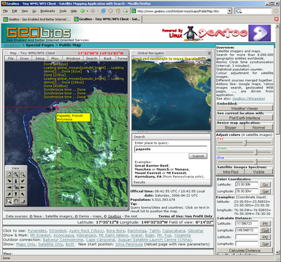
tables for Mediterranean, - Satellite imagery and maps with search for more than 8.000.000 geographic entities worldwide,
- Atomic ClockAtomic clockAn atomic clock is a clock that uses an electronic transition frequency in the microwave, optical, or ultraviolet region of the electromagnetic spectrum of atoms as a frequency standard for its timekeeping element...
synchronization, - Tools such as a Unit Converter, English Dictionary OnLine, ...
Features
Data used
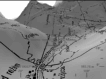
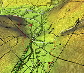
- Raster maps, starting from scale 1:5,000 to the scale 1:2,500,000. Software enables smooth zooming and panning through all scales.
- Geocoded data are represented by entities, which act as points, lines, polylines or areas. 2D and 3D. All information contained in the information service is geocoded. e.g. displayed on map.
Maps and geocoded data were obtained legally from the following companies and institutions:
- Ministry of Environment – Surveying and Mapping Authority of the Republic of Slovenia,
- Geodetic Institute of Republic of Slovenia,
- SAZU - Slovenian Academy of Sciences and ArtsSlovenian Academy of Sciences and ArtsThe Slovenian Academy of Sciences and Arts is the national academy of Slovenia, which encompasses science and the arts and brings together the top Slovene researchers and artists as members of the academy....
, - Geological Institute of Republic of Slovenia,
- Statistical Office of the Republic of SloveniaStatistical Office of the Republic of SloveniaStatistical Office of the Republic of Slovenia is an independent Slovenian state institution in charge of official statistical surveying. It is responsible directly to the Prime Minister of Slovenia...
, - Nasa - Jet Propulsion Laboratory
- AcademaAcademaACADEMA is a Slovenian software development company. The name of the company is an acronym forAdvanced Computer Aided Design Engineering Manufacturing Agency....
Ltd
Technology used
The web page is created as RIARich Internet application
A Rich Internet Application is a Web application that has many of the characteristics of desktop application software, typically delivered either by way of a site-specific browser, via a browser plug-in, independent sandboxes, extensive use of JavaScript, or virtual machines...
. The content is loaded in the background, javascript methods are changing the DOM
Document Object Model
The Document Object Model is a cross-platform and language-independent convention for representing and interacting with objects in HTML, XHTML and XML documents. Aspects of the DOM may be addressed and manipulated within the syntax of the programming language in use...
of the main page, which acts like a layout manager with so called floating windows. Different applications run concurrently in the environment of the web page and communicate among each other. The applications are built as pure javascript
JavaScript
JavaScript is a prototype-based scripting language that is dynamic, weakly typed and has first-class functions. It is a multi-paradigm language, supporting object-oriented, imperative, and functional programming styles....
, java
Java (programming language)
Java is a programming language originally developed by James Gosling at Sun Microsystems and released in 1995 as a core component of Sun Microsystems' Java platform. The language derives much of its syntax from C and C++ but has a simpler object model and fewer low-level facilities...
applets and flash applets.
History
Major changes:- May 1999, Aviator 2D/3D interactive maps (DHTML interface and ActiveXActiveXActiveX is a framework for defining reusable software components in a programming language-independent way. Software applications can then be composed from one or more of these components in order to provide their functionality....
/OpenGLOpenGLOpenGL is a standard specification defining a cross-language, cross-platform API for writing applications that produce 2D and 3D computer graphics. The interface consists of over 250 different function calls which can be used to draw complex three-dimensional scenes from simple primitives. OpenGL...
plug-in) - August 2000, 2D maps JavaJava (programming language)Java is a programming language originally developed by James Gosling at Sun Microsystems and released in 1995 as a core component of Sun Microsystems' Java platform. The language derives much of its syntax from C and C++ but has a simpler object model and fewer low-level facilities...
based interface, search for Slovenian addresses, restaurants, ... - May 2001, astronomyAstronomyAstronomy is a natural science that deals with the study of celestial objects and phenomena that originate outside the atmosphere of Earth...
, Aviator 2D/3D was removed (reason: support of MS IE only - criticism of NetscapeNetscapeNetscape Communications is a US computer services company, best known for Netscape Navigator, its web browser. When it was an independent company, its headquarters were in Mountain View, California...
users) - February 2002, Information kiosk system support
- May 2003, weatherWeatherWeather is the state of the atmosphere, to the degree that it is hot or cold, wet or dry, calm or stormy, clear or cloudy. Most weather phenomena occur in the troposphere, just below the stratosphere. Weather refers, generally, to day-to-day temperature and precipitation activity, whereas climate...
viewer modules added - July 2004, new design, more applications are running simultaneously
- June 2005, satellite imagerySatellite imagerySatellite imagery consists of photographs of Earth or other planets made by means of artificial satellites.- History :The first images from space were taken on sub-orbital flights. The U.S-launched V-2 flight on October 24, 1946 took one image every 1.5 seconds...
, mapsMAPSMaps is the plural of map, a visual representation of an area.As an acronym, MAPS may refer to:* Mail Abuse Prevention System, an organisation that provides anti-spam support...
and search for geographic entities worldwide added - September 2006, GeoRSSGeoRSSGeoRSS is an emerging standard for encoding location as part of a Web feed. GeoRSS is an emerging standard for encoding location as part of a Web feed. GeoRSS is an emerging standard for encoding location as part of a Web feed. (Web feeds are used to describe feeds ("channels") of content, such as...
Feed added - June 2007, Experimental video geo-search
Funding
A private company AcademaAcadema
ACADEMA is a Slovenian software development company. The name of the company is an acronym forAdvanced Computer Aided Design Engineering Manufacturing Agency....
Ltd is funding the GeaBios project entirely from its own sources.
External links
Special pages
- Satellite Mapping Application - Tiny WMS/WFS Client
- Overview: Satellite imagery and maps. Search for more than 8,000,000 geographic entities worldwide. Different sources merged together. Addons like: Google maps, Yahoo images search, geolocated Web pages, ..., are driven from the application. It is based on Open Geospatial ConsortiumOpen Geospatial ConsortiumThe Open Geospatial Consortium , an international voluntary consensus standards organization, originated in 1994. In the OGC, more than 400 commercial, governmental, nonprofit and research organizations worldwide collaborate in a consensus process encouraging development and implementation of open...
standards, and is created with Open Laszlo (open sourceOpen sourceThe term open source describes practices in production and development that promote access to the end product's source materials. Some consider open source a philosophy, others consider it a pragmatic methodology...
development platform) and DHTML. - Overview: Weather models from different sources merged together, time dependent animation, dynamic zoom, visual comparator, data gluing ability, ... The application is created as pure DHTML.
Web sites using GeaBios
- Mindat.org - mineralMineralA mineral is a naturally occurring solid chemical substance formed through biogeochemical processes, having characteristic chemical composition, highly ordered atomic structure, and specific physical properties. By comparison, a rock is an aggregate of minerals and/or mineraloids and does not...
location database - Mineralienatlas.de - mineralMineralA mineral is a naturally occurring solid chemical substance formed through biogeochemical processes, having characteristic chemical composition, highly ordered atomic structure, and specific physical properties. By comparison, a rock is an aggregate of minerals and/or mineraloids and does not...
and fossilFossilFossils are the preserved remains or traces of animals , plants, and other organisms from the remote past...
location database - Moodle - free, open sourceOpen sourceThe term open source describes practices in production and development that promote access to the end product's source materials. Some consider open source a philosophy, others consider it a pragmatic methodology...
course management system for online learning (see MoodleMoodleMoodle is a free source e-learning software platform, also known as a Course Management System, Learning Management System, or Virtual Learning Environment...
) - Ordinacija.net - the healthcare protection and service
- Wikipedia - external map source