
Gaviota State Park
Encyclopedia
Gaviota State Park is a California State Park located in southern Santa Barbara County, California
, U.S.
, about 33 miles (53 km) west of the city of Santa Barbara
. It consists of 2,790 acres (1,130 ha) extending from the Pacific
coast to the crest of the Santa Ynez Mountains
, and is adjacent to Los Padres National Forest
.
 The park is bisected by U.S. Route 101
, which turns north from the coast at Gaviota
, passing through the Gaviota Tunnel
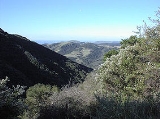
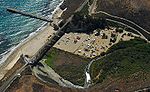
and Gaviota Pass, which is actually a deep canyon cut entirely through the southern branch of the Santa Ynez Mountains at this point. Gaviota State Park consists of two units, one on each side of the highway, as well as a State Beach. The state beach and its associated campground receives most of the park's visitors.
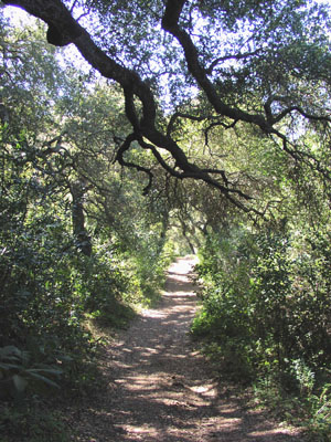 Both sections of the park contain trails for hiking, horseback riding, and mountain biking. The most heavily traveled trail is a short dirt road leading to a popular hot springs on the eastern side of the highway. A more substantial trail beginning at the same trailhead leads to the summit of Gaviota Peak
, the highest mountain in the vicinity at 2458 ft (749 m). While not exceptionally high, because it is an isolated peak the views are spectacular in all directions; on a clear day it is possible to see much of Santa Barbara County, as well as the coast as far south as the Santa Monica Mountains
.
Mountain lions may be encountered in the park, and warning signs are prominently posted. The park was closed for a month in 1992 following a near-fatal attack by a lion on a 10 year old boy.
in the upland regions, oak woodlands
elsewhere, and both native prairie
and non-native grassland
s. They are part of the California coastal sage and chaparral ecoregion
. The portion of Gaviota Creek that passes through the park includes one of the highest quality riparian habitat
s remaining in southern Santa Barbara County, and is receives strict environmental protection.
Much of the park vegetation was burned in a large brushfire in June 2004, with fire a natural part of the chaparral ecosystem.
, which extends for almost the entire distance to Point Conception
(where the California coast turns to the north). Access to this portion of the coast is tightly secured, and possible only by water for non-residents. Singer Jackson Browne
owns a ranch adjacent to the park on the west.
, with mild, rainy winters, and sunny summers, commonly with morning clouds. Temperatures below freezing are rare, and summertime high temperatures rise with increasing distance from the coast. Because of the topographical peculiarity of the region, a single deep canyon cut through the mountains, at certain times of year, most frequently in late spring, winds blow through the canyon with great force. These winds, known as Sundowners
, are common all along the south coast of Santa Barbara County, but are frequently most violent in the Gaviota area.
California
California is a state located on the West Coast of the United States. It is by far the most populous U.S. state, and the third-largest by land area...
, U.S.
United States
The United States of America is a federal constitutional republic comprising fifty states and a federal district...
, about 33 miles (53 km) west of the city of Santa Barbara
Santa Barbara, California
Santa Barbara is the county seat of Santa Barbara County, California, United States. Situated on an east-west trending section of coastline, the longest such section on the West Coast of the United States, the city lies between the steeply-rising Santa Ynez Mountains and the Pacific Ocean...
. It consists of 2,790 acres (1,130 ha) extending from the Pacific
Pacific Ocean
The Pacific Ocean is the largest of the Earth's oceanic divisions. It extends from the Arctic in the north to the Southern Ocean in the south, bounded by Asia and Australia in the west, and the Americas in the east.At 165.2 million square kilometres in area, this largest division of the World...
coast to the crest of the Santa Ynez Mountains
Santa Ynez Mountains
The Santa Ynez Mountains are a portion of the Transverse Ranges, part of the Pacific Coast Ranges of the west coast of North America, and are one of the northernmost mountain ranges in Southern California.-Geography:...
, and is adjacent to Los Padres National Forest
Los Padres National Forest
Los Padres National Forest is a forest located in southern and central California, which includes most of the mountainous land along the California coast from Ventura to Monterey, extending inland...
.
Location and geography
U.S. Route 101
U.S. Route 101, or U.S. Highway 101, is an important north–south U.S. highway that runs through the states of California, Oregon, and Washington, on the West Coast of the United States...
, which turns north from the coast at Gaviota
Gaviota, California
Gaviota is an unincorporated town in Santa Barbara County, California located about west of Santa Barbara and south of Buellton. Approximately 35 people live in and near Gaviota. The ZIP Code is 93117, and the community is inside area code 805....
, passing through the Gaviota Tunnel
Gaviota Tunnel
The Gaviota Tunnel is a tunnel on U.S. Route 101 completed in 1953 north of Gaviota State Park, 33 miles northwest of Santa Barbara, California. It is long and tall. Only the northbound lanes of U.S...
and Gaviota Pass, which is actually a deep canyon cut entirely through the southern branch of the Santa Ynez Mountains at this point. Gaviota State Park consists of two units, one on each side of the highway, as well as a State Beach. The state beach and its associated campground receives most of the park's visitors.
Trails
Gaviota Peak
Gaviota Peak is a summit in the Santa Ynez Mountains in Santa Barbara County, California. It is located west of Santa Barbara, east of Point Conception and from of the Pacific Ocean....
, the highest mountain in the vicinity at 2458 ft (749 m). While not exceptionally high, because it is an isolated peak the views are spectacular in all directions; on a clear day it is possible to see much of Santa Barbara County, as well as the coast as far south as the Santa Monica Mountains
Santa Monica Mountains
The Santa Monica Mountains are a Transverse Range in Southern California, along the coast of the Pacific Ocean in the United States.-Geography:...
.
Mountain lions may be encountered in the park, and warning signs are prominently posted. The park was closed for a month in 1992 following a near-fatal attack by a lion on a 10 year old boy.
Ecology
Plant communities in the park include chaparralChaparral
Chaparral is a shrubland or heathland plant community found primarily in the U.S. state of California and in the northern portion of the Baja California peninsula, Mexico...
in the upland regions, oak woodlands
California oak woodland
California oak woodland is a plant community found throughout the California chaparral and woodlands ecoregion of California in the United States and northwestern Baja California in Mexico...
elsewhere, and both native prairie
California coastal prairie
California coastal prairie, also known as northern coastal grassland, is a grassland plant community of California and Oregon in the Temperate grasslands, savannas, and shrublands Biome...
and non-native grassland
Grassland
Grasslands are areas where the vegetation is dominated by grasses and other herbaceous plants . However, sedge and rush families can also be found. Grasslands occur naturally on all continents except Antarctica...
s. They are part of the California coastal sage and chaparral ecoregion
Ecoregion
An ecoregion , sometimes called a bioregion, is an ecologically and geographically defined area that is smaller than an ecozone and larger than an ecosystem. Ecoregions cover relatively large areas of land or water, and contain characteristic, geographically distinct assemblages of natural...
. The portion of Gaviota Creek that passes through the park includes one of the highest quality riparian habitat
Habitat
* Habitat , a place where a species lives and grows*Human habitat, a place where humans live, work or play** Space habitat, a space station intended as a permanent settlement...
s remaining in southern Santa Barbara County, and is receives strict environmental protection.
Much of the park vegetation was burned in a large brushfire in June 2004, with fire a natural part of the chaparral ecosystem.
Region
Adjacent to the park on the west is a large region of private ranches and ranchettes known as Hollister RanchHollister Ranch
The region presently known as the Hollister Ranch is defined by of fallow and fertile fields, mountains and valleys along the Pacific Ocean of California between Gaviota State Park and Point Conception. It was the site of some of the oldest known human settlements in the new world, the last...
, which extends for almost the entire distance to Point Conception
Point Conception
Point Conception is a headland along the Pacific coast of U.S. state of California, located in southwestern Santa Barbara County. It is the point where the Santa Barbara Channel meets the Pacific Ocean, and as the corner between the mostly north-south trending portion of coast to the north and the...
(where the California coast turns to the north). Access to this portion of the coast is tightly secured, and possible only by water for non-residents. Singer Jackson Browne
Jackson Browne
Jackson Browne is an American singer-songwriter and musician who has sold over 17 million albums in the United States alone....
owns a ranch adjacent to the park on the west.
Campground
The park includes a beach campground, which contains 39 campsites for RVs (up to 25 feet for most sites) and for tents. There is also a fishing pier which includes a small boat hoist; also nearby are some favorite surfing locations. There are no hook-ups or dump station.Climate
The park is subject to a Mediterranean climateMediterranean climate
A Mediterranean climate is the climate typical of most of the lands in the Mediterranean Basin, and is a particular variety of subtropical climate...
, with mild, rainy winters, and sunny summers, commonly with morning clouds. Temperatures below freezing are rare, and summertime high temperatures rise with increasing distance from the coast. Because of the topographical peculiarity of the region, a single deep canyon cut through the mountains, at certain times of year, most frequently in late spring, winds blow through the canyon with great force. These winds, known as Sundowners
Sundowner (wind)
A sundowner is an offshore northerly Foehn wind in Santa Barbara, California. It occurs when a region of high pressure is directly north of the area, whose coast trends east–west. This contrasts with the more typical onshore flow...
, are common all along the south coast of Santa Barbara County, but are frequently most violent in the Gaviota area.