
Gateway Boulevard
Encyclopedia
Gateway Boulevard is a one-way major arterial
in south Edmonton
, Alberta
, Canada
. It is a major commuter route for communities south of Edmonton, such Leduc
.
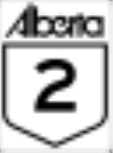
Gateway Boulevard runs in a northbound direction, beginning at the City of Edmonton limits as Alberta Highway 2. It continues past South Edmonton Common
as a two-way freeway separated by a median
; for this portion, the roadway actually has two names, the southbound Calgary Trail
, and northbound Gateway Boulevard. Near 31 Avenue, Calgary Trail and Gateway Boulevard separate and become one-way
arterials. Highway 2 continues along Whitemud Drive west, while Gateway Boulevard continues towards the city centre. Calgary Trail (104 Street) and Gateway Boulevard continue to run parallel through Old Strathcona
to Saskatchewan Drive, where they end.
following the rail lines. The rails no longer continue north past Whyte Avenue, however CPR
still has a rail yard serving the industrial district along the east side of Gateway Boulevard.
Arterial road
An arterial road, or arterial thoroughfare, is a high-capacity urban road. The primary function of an arterial road is to deliver traffic from collector roads to freeways, and between urban centres at the highest level of service possible. As such, many arteries are limited-access roads, or feature...
in south Edmonton
Edmonton
Edmonton is the capital of the Canadian province of Alberta and is the province's second-largest city. Edmonton is located on the North Saskatchewan River and is the centre of the Edmonton Capital Region, which is surrounded by the central region of the province.The city and its census...
, Alberta
Alberta
Alberta is a province of Canada. It had an estimated population of 3.7 million in 2010 making it the most populous of Canada's three prairie provinces...
, Canada
Canada
Canada is a North American country consisting of ten provinces and three territories. Located in the northern part of the continent, it extends from the Atlantic Ocean in the east to the Pacific Ocean in the west, and northward into the Arctic Ocean...
. It is a major commuter route for communities south of Edmonton, such Leduc
Leduc, Alberta
- Demographics :The population of the City of Leduc according to its 2011 municipal census is 24,139, a 3.6% increase over its 2010 municipal census population of 23,293....
.
Gateway Boulevard runs in a northbound direction, beginning at the City of Edmonton limits as Alberta Highway 2. It continues past South Edmonton Common
South Edmonton Common
South Edmonton Common is Canada's largest retail power centre, and when fully developed, it will spread over and contain some of retail space, making it the largest open-air retail development in North America. It is located in south Edmonton, Alberta at 23 Avenue NW and Gateway Boulevard.This...
as a two-way freeway separated by a median
Central reservation
On divided roads, such as divided highways or freeways/motorways, the central reservation , median, parkway , median strip or central nature strip is the area which separates opposing lanes of traffic...
; for this portion, the roadway actually has two names, the southbound Calgary Trail
Calgary Trail
Calgary Trail is a major one-way arterial in south Edmonton, Alberta, Canada. It is a major commuter route for communities south of Edmonton, such as Leduc....
, and northbound Gateway Boulevard. Near 31 Avenue, Calgary Trail and Gateway Boulevard separate and become one-way
One-way traffic
One-way traffic is traffic that moves in a single direction. A one-way street is a street either facilitating only one-way traffic, or designed to direct vehicles to move in one direction.-General signs:...
arterials. Highway 2 continues along Whitemud Drive west, while Gateway Boulevard continues towards the city centre. Calgary Trail (104 Street) and Gateway Boulevard continue to run parallel through Old Strathcona
Old Strathcona
Old Strathcona is an historic district located in south-central Edmonton, Alberta, Canada. Once the commercial core of the separate city of Strathcona, the area is now Edmonton's main arts and entertainment district, and in 2007 was named Alberta's second "Provincial Historic Area"...
to Saskatchewan Drive, where they end.
History
Gateway Boulevard was formerly known as Calgary Trail Northbound (south of 55 Avenue) and 103 Street (between 55 Avenue and Saskatchewan Drive), but in 2001, the entire stretch was renamed. Initially, the name change met with some controversy. The name Calgary Trail stood for many years, as this was Alberta's primary highway to CalgaryCalgary
Calgary is a city in the Province of Alberta, Canada. It is located in the south of the province, in an area of foothills and prairie, approximately east of the front ranges of the Canadian Rockies...
following the rail lines. The rails no longer continue north past Whyte Avenue, however CPR
Canadian Pacific Railway
The Canadian Pacific Railway , formerly also known as CP Rail between 1968 and 1996, is a historic Canadian Class I railway founded in 1881 and now operated by Canadian Pacific Railway Limited, which began operations as legal owner in a corporate restructuring in 2001...
still has a rail yard serving the industrial district along the east side of Gateway Boulevard.
Neighbourhoods
List of neighbourhoods Gateway Boulevard runs through, in order from south to north.- Blackmud CreekBlackmud Creek, EdmontonBlackmud Creek is a new residential neighbourhood in south west Edmonton, Alberta, Canada.The neighbourhood is bounded on the west by the James Mowat Trail , and on the north by Ellerslie Road...
- BlackburneBlackburne, EdmontonBlackburne is a newer neighbourhood in south west Edmonton, Alberta, Canada. It is an irregularly shaped neighbourhood whose south west boundary overlooks the Blackmud Creek Ravine. It is bounded by Anthony Henday Drive to the north and by Calgary Trail to the east...
- BearspawBearspaw, EdmontonBearspaw, a residential neighbourhood located in south west Edmonton, Alberta, Canada, is named after the Stony Indian Chief Masgwaahisd . It is located close to the shopping and services located in Century Park, Gateway Boulevard, and South Edmonton Common.According to the 2001 federal census,...
- KeheewinKeheewin, EdmontonKeheewin is a residential neighbourhood located in south west Edmonton, Alberta, Canada. The name means "eagle" in the Cree language.The neighbourhood is bounded on the west by 111 Street, on the east by Calgary Trail/Gateway Boulevard, and on the north by 23 Avenue. The south boundary is located...
- ErmineskinErmineskin, EdmontonErmineskin is a residential neighbourhood in south west Edmonton, Alberta, Canada. The neighbourhood is named for Chief Ermineskin of Hobbema.The neighbourhood is bounded on the west by 111 Street, on the south by 23 Avenue, and on the east by Calgary Trail and Gateway Boulevard...
- SteinhauerSteinhauer, EdmontonSteinhauer is a residential neighbourhood in SW Edmonton. "The neighbourhood is named for a missionary who settled in Alberta during the mid-1800s," Henry Bird Steinhauer....
- DugganDuggan, EdmontonDuggan is a residential neighbourhood in south Edmonton, Alberta, Canada. The neighbourhood is "named for J.J. Duggan "....
- Rideau ParkRideau Park, EdmontonRideau Park is a residential neighbourhood in south west Edmonton, Alberta, Canada. The name Rideau means curtain in the French Language.The neighbourhood is bounded on the west by 111 Street, on the east by Calgary Trail, on the north by Whitemud Drive, and on the south by 40 Avenue, 106 Street,...
- Empire ParkEmpire Park, EdmontonEmpire Park is a residential neighbourhood in south west Edmonton, Alberta, Canada. A major shopping centre, Southgate Centre, is located at the west end of the neighbourhood....
- PleasantviewPleasantview, EdmontonPleasantview is a residential neighbourhood in south west Edmonton, Alberta, Canada.The neighbourhood is bounded on the west by 111 Street, on the east by 104 Street/Calgary Trail, on the south by 51 Avenue and on the north by 61 Avenue....
- AllendaleAllendale, EdmontonAllendale is a residential neighbourhood located in south west Edmonton, Alberta, Canada. The neighbourhood is named for the Allen family, who farmed the area before it was annexed by the City of Strathcona in 1907....
- Queen AlexandraQueen Alexandra, EdmontonQueen Alexandra is a mixed residential and commercial neighbourhood in south west Edmonton, Alberta, Canada. The neighbourhood, once part of the City of Strathcona, is named for Alexandra, the wife of Edward VII of England...
- StrathconaStrathcona, EdmontonStrathcona is a residential neighbourhood in south central Edmonton, Alberta, Canada. It is a part of, and should not be confused with, Old Strathcona, although much of the Strathcona neighbourhood is in Old Strathcona...
Interchanges and intersections
This is a list of major intersections, starting at the south end of Gateway Boulevard.| Direction | Intersecting road | Current intersection type | Coordinates |
|---|---|---|---|
| South-North | 41 Avenue SW | At-grade | 53°23′45"N 113°30′29"W |
| Ellerslie Road (9 Avenue SW) Ellerslie Road Ellerslie Road is a major arterial road in south Edmonton, Alberta, Canada. Before the City of Edmonton expanded this far south, it was rural grid road Township Road 514, earning the nickname Ellerslie Road... |
Diamond interchange Diamond interchange A diamond interchange is a common type of road junction, used where a freeway crosses a minor road. The freeway itself is grade-separated from the minor road, one crossing the other over a bridge... |
53°25′29"N 113°29′35"W | |
| Anthony Henday Drive | Stack interchange Stack interchange A stack interchange is a free-flowing grade separated junction between two roads.In countries where one drives on the right, left turns are handled by semi-directional flyover/under ramps... |
53°26′14"N 113°29′25"W | |
| 19 Avenue NW | At-grade (northbound exit only) | 53°26′48"N 113°29′33"W | |
| 23 Avenue NW 23 Avenue, Edmonton 23 Avenue NW is a major arterial road in south Edmonton. It runs through several neighbourhoods including Mill Woods and The Meadows, and commercial areas including South Edmonton Common, and Mill Woods Town Centre Mall. In mid-2007 construction of an interchange started at the intersection with... |
Diamond interchange Diamond interchange A diamond interchange is a common type of road junction, used where a freeway crosses a minor road. The freeway itself is grade-separated from the minor road, one crossing the other over a bridge... |
53°27′14"N 113°29′33"W | |
| Calgary Trail Calgary Trail Calgary Trail is a major one-way arterial in south Edmonton, Alberta, Canada. It is a major commuter route for communities south of Edmonton, such as Leduc.... |
(South end of diamond) | 53°27′39"N 113°29′33"W | |
| 34 Avenue NW 34 Avenue, Edmonton 34 Avenue NW is a major arterial road in south Edmonton, Alberta, Canada. It mostly runs through residential neighborhoods, with the exception of an area between 91 Street and Calgary Trail, sometimes called "Auto Row", due to all the car dealerships along the route... |
At-grade (traffic lights) | 53°28′4"N 113°29′31"W | |
| G.A. MacDonald Avenue | At-grade (traffic lights) | 53°28′33"N 113°29′31"W | |
| Whitemud Drive Whitemud Drive Whitemud Drive is the main east-west freeway in southern Edmonton, Alberta, Canada. It is one of few roads in Edmonton that has controlled access and limited at-grade intersections with traffic signals. It currently functions as a freeway between Anthony Henday Drive in the west and Anthony Henday... |
Diamond interchange | 53°28′50"N 113°29′31"W | |
| 51 Avenue | At-grade (traffic lights) | 53°29′17"N 113°29′31"W | |
| 54 Avenue | At-grade | 53°29′26"N 113°29′31"W | |
| 61 Avenue | At-grade | 53°29′56"N 113°29′35"W | |
| Allendale Road / 63 Avenue | At-grade (traffic lights) | 53°30′0"N 113°29′38"W | |
| University Avenue University Avenue (Edmonton) University Avenue was an arterial road in west Strathcona, Alberta, Canada. It was formed along the backs of farm lots west of the yet to be incorporated town of Strathcona, causing it to run parallel with the North Saskatchewan River to the north. The farm lots later became the University of... |
At-grade | 53°30′40"N 113°29′40"W | |
| Whyte (82) Avenue | At-grade (traffic lights) | 53°31′5"N 113°29′42"W | |
| Saskatchewan Drive Saskatchewan Drive Saskatchewan Drive / Scona Road is a river valley road on the south side of the North Saskatchewan River in Edmonton, Alberta, Canada. It was formed on the banks of the river when the area was known as the City of Strathcona... |
At-grade | 53°31′25"N 113°29′45"W |