
GPS navigation device
Encyclopedia
A GPS navigation device is any device that receives Global Positioning System
(GPS) signals for the purpose of determining the device's current location on Earth. GPS devices provide latitude
and longitude
information, and some may also calculate altitude
, although this is not considered sufficiently accurate or continuously available enough (due to the possibility of signal blockage and other factors) to rely on exclusively to pilot aircraft. GPS devices are used in military, aviation, marine and consumer product applications.
GPS devices may also have additional capabilities such as:
In other words, all GPS devices can answer the question "Where am I?", and may also be able to answer:
 Dedicated devices have various degrees of mobility. Hand-held, outdoor, or sport receivers have replaceable batteries that can run them for several hours, making them suitable for hiking
, bicycle touring
and other activities far from an electric power source. Their screens are small, and some do not show color, in part to save power. Cases are rugged and some are water resistant.
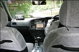
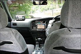
Other receivers, often called mobile are intended primarily for use in a car, but have a small rechargeable internal battery that can power them for an hour or two away from the car. Special purpose devices for use in a car may be permanently installed and depend entirely on the automotive electrical system.
The pre-installed embedded software of early receivers did not display maps; 21st century ones commonly show interactive street maps (of certain regions) that may also show points of interest
, route information and step-by-step routing directions, often in spoken form with a feature called "text to speech".
Manufacturers include:
, including E911, the majority of GPS receivers are built into mobile telephones, with varying degrees of coverage and user accessibility. Commercial navigation software is available for most 21st century smartphone
s as well as some Java
-enabled phones that allows them to use an internal or external GPS receiver (in the latter case, connecting via serial
or Bluetooth
). Some phones with GPS capability work by assisted GPS
(A-GPS) only, and do not function when out of range of their carrier's cell towers. Others can navigate worldwide with satellite GPS signals as a dedicated portable GPS receiver does, upgrading their operation to A-GPS mode when in range. Still others have a hybrid positioning system
that can use other signals when GPS signals are inadequate.
More bespoke
solutions also exist for smartphone
s with inbuilt GPS capabilities. Some such phones can use tethering to double as a wireless modem
for a laptop
, while allowing GPS-navigation/localisation as well. One such example is marketed by Verizon Wireless
in the United States
, and is called VZ Navigator
. The system uses gpsOne
technology to determine the location, and then uses the mobile phone's data connection to download maps and calculate navigational routes. Other products including iPhone
are used to provide similar services. Nokia
gives Ovi Maps free on its smartphones and maps can be preloaded. According to market research from the independent analyst firm Berg Insight, the sales of GPS-enabled GSM/WCDMA handsets was 150 million units in 2009, while only 40 million separate GPS receivers were sold.
GPS navigation applications for mobile phones include Waze
and Google Maps Navigation. Google Maps Navigation included with Android means most smartphone users only need their phone to have a personal navigation assistant
.
programs for in-vehicle use on laptop computers. Benefits of GPS on a laptop include larger map overview, ability to use the keyboard to control GPS functions, and some GPS software for laptops offers advanced trip-planning features not available on other platforms.
.jpg) Other GPS devices need to be connected to a computer in order to work. This computer can be a home computer
Other GPS devices need to be connected to a computer in order to work. This computer can be a home computer
, laptop
or even a PDAs
, or smartphone
s. Depending on the type of computer and available connectors, connections can be made through a serial
or USB
cable, as well as Bluetooth
, CompactFlash
, SD
, PCMCIA
and the newer ExpressCard
. Some PCMCIA/ExpressCard GPS units also include a wireless modem
. Devices usually do not come with pre-installed GPS navigation software
, thus, once purchased, the user must install or write their own software. As the user can choose which software to use, it can be better matched to their personal taste. It is very common for a PC-based GPS receiver to come bundled with a navigation software suite. Also, GPS modules are significantly cheaper than complete stand-alone systems (around €
50 to €100). The software may include maps only for a particular region, or the entire world, if softwares such as Google Maps, Networks in Motion's AtlasBook mobile navigation platform
, etc., are used.
Some hobbyists have also made some GPS devices and open-sourced the plans. Examples include the Elektor GPS units. These are based around a SiRFstarIII chip and are comparable to their commercial counterparts.
, course information and correction displays to the pilots, and course tracking and recording devices.
Global Positioning System
The Global Positioning System is a space-based global navigation satellite system that provides location and time information in all weather, anywhere on or near the Earth, where there is an unobstructed line of sight to four or more GPS satellites...
(GPS) signals for the purpose of determining the device's current location on Earth. GPS devices provide latitude
Latitude
In geography, the latitude of a location on the Earth is the angular distance of that location south or north of the Equator. The latitude is an angle, and is usually measured in degrees . The equator has a latitude of 0°, the North pole has a latitude of 90° north , and the South pole has a...
and longitude
Longitude
Longitude is a geographic coordinate that specifies the east-west position of a point on the Earth's surface. It is an angular measurement, usually expressed in degrees, minutes and seconds, and denoted by the Greek letter lambda ....
information, and some may also calculate altitude
Altitude
Altitude or height is defined based on the context in which it is used . As a general definition, altitude is a distance measurement, usually in the vertical or "up" direction, between a reference datum and a point or object. The reference datum also often varies according to the context...
, although this is not considered sufficiently accurate or continuously available enough (due to the possibility of signal blockage and other factors) to rely on exclusively to pilot aircraft. GPS devices are used in military, aviation, marine and consumer product applications.
GPS devices may also have additional capabilities such as:
- containing maps, which may be displayed in human readable format via text or in a graphical format
- providing suggested directions to a human in charge of a vehicle or vessel via text or speech
- providing directions directly to an autonomous vehicleDriverless carAn autonomous car, also known as robotic or informally as driverless, is an autonomous vehicle capable of fulfilling the human transportation capabilities of a traditional car. As an autonomous vehicle, it is capable of sensing its environment and navigating on its own...
such as a robotic probe - providing information on traffic conditions (either via historical or real time data) and suggesting alternative directions
- providing information on nearby amenities such as restaurants, fueling stations, etc.
In other words, all GPS devices can answer the question "Where am I?", and may also be able to answer:
- which roads or paths are available to me now?
- which roads or paths should I take in order to get to my desired destination?
- if some roads are usually busy at this time or are busy right now, what would be a better route to take?
- where can I get something to eat nearby or where can I get fuel for my vehicle?
Consumer applications
Consumer GPS navigation devices include:- Dedicated GPS navigation devices
- GPS modules that need to be connected to a computer to be used
- GPS loggers that record trip information for download. Such GPS trackingGPS trackingA GPS tracking unit is a device that uses the Global Positioning System to determine the precise location of a vehicle, person, or other asset to which it is attached and to record the position of the asset at regular intervals...
is useful for trailblazing, mapping by hikers and cyclists, and the production of geocoded photographs. - Converged devices, including GPS Phones and GPS camerasAuto-geotaggingReal-time geotagging is a name given to the automatic technique of acquiring media , associating a specific location with the media, transferring the media to an online map and publishing the media in real time...
, in which GPS is a feature rather than the main purpose of the device. Those devices are the majority, and may use assisted GPSAssisted GPSAssisted GPS, generally abbreviated as A-GPS or aGPS, is a system which can, under certain conditions, improve the startup performance, or time-to-first-fix of a GPS satellite-based positioning system. It is used extensively with GPS-capable cellular phones as its development was accelerated by...
or standalone (not network dependent) or both. The vulnerability of consumer GPS to radio frequency interference from planned wireless data services is controversial.
Dedicated GPS navigation devices
Hiking
Hiking is an outdoor activity which consists of walking in natural environments, often in mountainous or other scenic terrain. People often hike on hiking trails. It is such a popular activity that there are numerous hiking organizations worldwide. The health benefits of different types of hiking...
, bicycle touring
Bicycle touring
Bicycle touring is cycling over long distances – prioritizing pleasure and endurance over utility or speed. Touring can range from single day 'supported' rides — e.g., rides to benefit charities — where provisions are available to riders at stops along the route, to multi-day...
and other activities far from an electric power source. Their screens are small, and some do not show color, in part to save power. Cases are rugged and some are water resistant.
Other receivers, often called mobile are intended primarily for use in a car, but have a small rechargeable internal battery that can power them for an hour or two away from the car. Special purpose devices for use in a car may be permanently installed and depend entirely on the automotive electrical system.
The pre-installed embedded software of early receivers did not display maps; 21st century ones commonly show interactive street maps (of certain regions) that may also show points of interest
Point of interest
A point of interest, or POI, is a specific point location that someone may find useful or interesting. An example is a point on the Earth representing the location of the Space Needle, or a point on Mars representing the location of the mountain, Olympus Mons.The term is widely used in...
, route information and step-by-step routing directions, often in spoken form with a feature called "text to speech".
Manufacturers include:
- Navman products
- TomTom products
- Garmin products
- Mio productsMio TechnologyMio Technology Corporation, a subsidiary of Mitac Int'l Corp., is a Taiwanese electronics maker that manufactures and markets Pocket PCs, Personal Digital Assistants , smartphones and Personal Navigation Devices...
- Navigon products
- Magellan Navigation consumer products
- TeleType products
Mobile phones with GPS capability
Due in part to regulations encouraging mobile phone trackingMobile phone tracking
Mobile phone tracking refers to the attaining of the current position of a mobile phone, stationary or moving. Localization may occur either via multilateration of radio signals between radio towers of the network and the phone, or simply via GPS...
, including E911, the majority of GPS receivers are built into mobile telephones, with varying degrees of coverage and user accessibility. Commercial navigation software is available for most 21st century smartphone
Smartphone
A smartphone is a high-end mobile phone built on a mobile computing platform, with more advanced computing ability and connectivity than a contemporary feature phone. The first smartphones were devices that mainly combined the functions of a personal digital assistant and a mobile phone or camera...
s as well as some Java
Java (programming language)
Java is a programming language originally developed by James Gosling at Sun Microsystems and released in 1995 as a core component of Sun Microsystems' Java platform. The language derives much of its syntax from C and C++ but has a simpler object model and fewer low-level facilities...
-enabled phones that allows them to use an internal or external GPS receiver (in the latter case, connecting via serial
Serial communications
In telecommunication and computer science, serial communication is the process of sending data one bit at a time, sequentially, over a communication channel or computer bus. This is in contrast to parallel communication, where several bits are sent as a whole, on a link with several parallel channels...
or Bluetooth
Bluetooth
Bluetooth is a proprietary open wireless technology standard for exchanging data over short distances from fixed and mobile devices, creating personal area networks with high levels of security...
). Some phones with GPS capability work by assisted GPS
Assisted GPS
Assisted GPS, generally abbreviated as A-GPS or aGPS, is a system which can, under certain conditions, improve the startup performance, or time-to-first-fix of a GPS satellite-based positioning system. It is used extensively with GPS-capable cellular phones as its development was accelerated by...
(A-GPS) only, and do not function when out of range of their carrier's cell towers. Others can navigate worldwide with satellite GPS signals as a dedicated portable GPS receiver does, upgrading their operation to A-GPS mode when in range. Still others have a hybrid positioning system
Hybrid positioning system
Hybrid positioning systems are systems for finding the location of a mobile device using several different positioning technologies. Usually GPS is one major component of such systems, combined with cell tower signals, wireless internet signals, Bluetooth sensors or other local Positioning...
that can use other signals when GPS signals are inadequate.
More bespoke
Bespoke
Bespoke is a term employed in a variety of applications to mean an item custom-made to the buyer's specification...
solutions also exist for smartphone
Smartphone
A smartphone is a high-end mobile phone built on a mobile computing platform, with more advanced computing ability and connectivity than a contemporary feature phone. The first smartphones were devices that mainly combined the functions of a personal digital assistant and a mobile phone or camera...
s with inbuilt GPS capabilities. Some such phones can use tethering to double as a wireless modem
Wireless modem
A wireless modem is a type of modulator-demodulator which connects to a wireless network instead of using telephone or cable television lines...
for a laptop
Laptop
A laptop, also called a notebook, is a personal computer for mobile use. A laptop integrates most of the typical components of a desktop computer, including a display, a keyboard, a pointing device and speakers into a single unit...
, while allowing GPS-navigation/localisation as well. One such example is marketed by Verizon Wireless
Verizon Wireless
Cellco Partnership, doing business as Verizon Wireless, is one of the largest mobile network operators in the United States. The network has 107.7 million subscribers as of 2011, making it the largest wireless service provider in America....
in the United States
United States
The United States of America is a federal constitutional republic comprising fifty states and a federal district...
, and is called VZ Navigator
VZ Navigator
VZ Navigator is a GPS navigation software for Verizon Wireless phones that turns the phone into a GPS navigation device. It is a white label product based on Networks in Motion's AtlasBook mobile navigation platform. It is compatible with many recent Verizon GPS Phones, and available through Get It...
. The system uses gpsOne
GpsOne
gpsOne is the brand name for a cellphone chipset manufactured by Qualcomm that allows cell phones to more accurately plot a user's position, using a technology referred to as A-GPS or Assisted-GPS...
technology to determine the location, and then uses the mobile phone's data connection to download maps and calculate navigational routes. Other products including iPhone
IPhone
The iPhone is a line of Internet and multimedia-enabled smartphones marketed by Apple Inc. The first iPhone was unveiled by Steve Jobs, then CEO of Apple, on January 9, 2007, and released on June 29, 2007...
are used to provide similar services. Nokia
Nokia
Nokia Corporation is a Finnish multinational communications corporation that is headquartered in Keilaniemi, Espoo, a city neighbouring Finland's capital Helsinki...
gives Ovi Maps free on its smartphones and maps can be preloaded. According to market research from the independent analyst firm Berg Insight, the sales of GPS-enabled GSM/WCDMA handsets was 150 million units in 2009, while only 40 million separate GPS receivers were sold.
GPS navigation applications for mobile phones include Waze
Waze
Waze is a free GPS application featuring turn-by-turn navigation, developed by the Israeli start-up Waze Mobile for mobile phones. It currently supports iOS, Android, Windows Mobile, Symbian, and BlackBerry. Waze differs from traditional GPS navigation software as it is a community-driven...
and Google Maps Navigation. Google Maps Navigation included with Android means most smartphone users only need their phone to have a personal navigation assistant
Personal navigation assistant
A Personal Navigation Assistant also known as Personal Navigation Device or Portable Navigation Device is a portable electronic product which combines a positioning capability and navigation functions....
.
Laptop PC GPS
Various software companies have made available GPS navigation softwareGPS navigation software
GPS navigation software usually falls into one of the following two categories:# Navigation with route calculation and directions from the software to the user of the route to take, based on a vector-based map, normally for motorised vehicles with some motorised forms added on as an afterthought.#...
programs for in-vehicle use on laptop computers. Benefits of GPS on a laptop include larger map overview, ability to use the keyboard to control GPS functions, and some GPS software for laptops offers advanced trip-planning features not available on other platforms.
GPS modules
Home computer
Home computers were a class of microcomputers entering the market in 1977, and becoming increasingly common during the 1980s. They were marketed to consumers as affordable and accessible computers that, for the first time, were intended for the use of a single nontechnical user...
, laptop
Laptop
A laptop, also called a notebook, is a personal computer for mobile use. A laptop integrates most of the typical components of a desktop computer, including a display, a keyboard, a pointing device and speakers into a single unit...
or even a PDAs
Personal digital assistant
A personal digital assistant , also known as a palmtop computer, or personal data assistant, is a mobile device that functions as a personal information manager. Current PDAs often have the ability to connect to the Internet...
, or smartphone
Smartphone
A smartphone is a high-end mobile phone built on a mobile computing platform, with more advanced computing ability and connectivity than a contemporary feature phone. The first smartphones were devices that mainly combined the functions of a personal digital assistant and a mobile phone or camera...
s. Depending on the type of computer and available connectors, connections can be made through a serial
Serial cable
A serial cable is a cable that can be used to transfer information between two devices using serial communication. The form of connectors depends on the particular PHY used...
or USB
Universal Serial Bus
USB is an industry standard developed in the mid-1990s that defines the cables, connectors and protocols used in a bus for connection, communication and power supply between computers and electronic devices....
cable, as well as Bluetooth
Bluetooth
Bluetooth is a proprietary open wireless technology standard for exchanging data over short distances from fixed and mobile devices, creating personal area networks with high levels of security...
, CompactFlash
CompactFlash
CompactFlash is a mass storage device format used in portable electronic devices. Most CompactFlash devices contain flash memory in a standardized enclosure. The format was first specified and produced by SanDisk in 1994...
, SD
Secure Digital card
Secure Digital is a non-volatile memory card format developed by the SD Card Association for use in portable devices. The SD technology is used by more than 400 brands across dozens of product categories and more than 8,000 models, and is considered the de-facto industry standard.Secure Digital...
, PCMCIA
PC Card
In computing, PC Card is the form factor of a peripheral interface designed for laptop computers. The PC Card standard was defined and developed by the Personal Computer Memory Card International Association which itself was created by a number of computer industry companies in the United States...
and the newer ExpressCard
ExpressCard
ExpressCard is an interface to allow peripheral devices to be connected to a computer, usually a laptop computer. Formerly called NEWCARD, the ExpressCard standard specifies the design of slots built into the computer and of cards which can be inserted into ExpressCard slots. The cards contain...
. Some PCMCIA/ExpressCard GPS units also include a wireless modem
Wireless modem
A wireless modem is a type of modulator-demodulator which connects to a wireless network instead of using telephone or cable television lines...
. Devices usually do not come with pre-installed GPS navigation software
GPS navigation software
GPS navigation software usually falls into one of the following two categories:# Navigation with route calculation and directions from the software to the user of the route to take, based on a vector-based map, normally for motorised vehicles with some motorised forms added on as an afterthought.#...
, thus, once purchased, the user must install or write their own software. As the user can choose which software to use, it can be better matched to their personal taste. It is very common for a PC-based GPS receiver to come bundled with a navigation software suite. Also, GPS modules are significantly cheaper than complete stand-alone systems (around €
Euro
The euro is the official currency of the eurozone: 17 of the 27 member states of the European Union. It is also the currency used by the Institutions of the European Union. The eurozone consists of Austria, Belgium, Cyprus, Estonia, Finland, France, Germany, Greece, Ireland, Italy, Luxembourg,...
50 to €100). The software may include maps only for a particular region, or the entire world, if softwares such as Google Maps, Networks in Motion's AtlasBook mobile navigation platform
VZ Navigator
VZ Navigator is a GPS navigation software for Verizon Wireless phones that turns the phone into a GPS navigation device. It is a white label product based on Networks in Motion's AtlasBook mobile navigation platform. It is compatible with many recent Verizon GPS Phones, and available through Get It...
, etc., are used.
Some hobbyists have also made some GPS devices and open-sourced the plans. Examples include the Elektor GPS units. These are based around a SiRFstarIII chip and are comparable to their commercial counterparts.
Commercial aviation
Commercial aviation applications include GPS devices that calculate location and feed that information to large multi-input navigational computers for autopilotAutopilot
An autopilot is a mechanical, electrical, or hydraulic system used to guide a vehicle without assistance from a human being. An autopilot can refer specifically to aircraft, self-steering gear for boats, or auto guidance of space craft and missiles...
, course information and correction displays to the pilots, and course tracking and recording devices.
Military
Military applications include devices similar to consumer sport products for foot soldiers (commanders and regular soldiers), small vehicles and ships, and devices similar to commercial aviation applications for aircraft and missiles. Examples are the United States military's Commander's Digital Assistant and the Soldier Digital Assistant.See also
- Defense Advanced GPS ReceiverDefense Advanced GPS ReceiverThe Defense Advanced GPS Receiver is a handheld GPS receiver used by the United States Department of Defense and select foreign military services...
- Precision Lightweight GPS ReceiverPrecision Lightweight GPS ReceiverThe Precision Lightweight GPS Receiver is a ruggedized, hand-held, single-frequency GPS receiver fielded by the US military...
- GPS Clocks