
Fort-Liberté
Encyclopedia
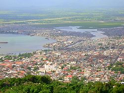
Fort-Liberté is the administrative capital of the Nord-Est Department
, Haiti
. It is close to the border of the Dominican Republic
and is one of the oldest cities in the country. Haiti's independence was proclaimed here on November 29, 1803. The area around Fort-Liberté was originally inhabited by Indians
, and later by colonists, starting with the Spanish. It was founded as a city in 1578 by the French, was occupied by the British in 1790, captured
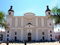
by the Spanish forces in 1794 and restored to the French in 1801 until independence in 1803. The city has undergone a succession of name changes, in the order of Bayaha (1578), Fort-Dauphin (1732), Fort St. Joseph (1804), Fort-Royal (1811) and finally as Fort-Liberté since 1820. The town is part of the Roman Catholic Diocese of Fort-Liberté
.
is spoken in this area with the more educated speaking French. Religion is Roman Catholic and Haitian Vodou. Educational institutions have been established from time to time in various parts of the island.
, which borders the Dominican Republic. Nord-Est (North-East) is one of the ten departments (départements) of Haiti
. Nord-Est has an area of 1805 square kilometre and a population of 283,800 (2002). The arrondissement
consists of the three municipalities of Fort-Liberté, Ferrier
and Perches
. In the colonial era, it was a major plantation area and remains an important coffee producing area. Its pine forests are heavily exploited for charcoal. In addition, several era colonial forts, mostly in ruins, are situated here.
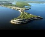
Fort-Liberté is a natural harbour of the Saint Domingue. It is strategically located in the centre of the bay facing the Atlantic Ocean. It was once a strategic naval base of the French, which was established by them in 1731. The town was militarily fortified by the French with four fort structural bases that "guarded the bay like beads on a string." Two of the larger forts are Fort Lachatre and Fort Labourque
. The fort was captured by Toussaint Louverture (May 20, 1743 – April 7, 1803), the leader of the Haitian Revolution
, in 1793 who later proceeded to the north and conquered the Spanish. Its historic importance is also because it served as the antislavery movement that started here. Now, it is an economically weak territory.
The fort is 40 nautical miles (74.1 km) from Port-de-Paix
(the capital of the Nord-Ouest Department) and290 kilometres (180.2 mi) from Port-au-Prince
(capital of Haiti). The average elevation of the town is about1 metres (3.3 ft).
.jpg) Between 1503 and 1505, Nicolás de Ovando
Between 1503 and 1505, Nicolás de Ovando
, Spanish governor
of Hispaniola
, founded the town of Puerto Real
("Royal Port"), which today lies around the town of Caracol, to the west of Fort-Liberté. However, soon this town was abandoned and the people moved to the east and in 1578 a new town was founded with the Taíno
name of the region, Bayajá. Caracol was thought to be near the location where Santa Maria, Columbus's flagship struck a reef and sank on Christmas Day in 1492. The shipwreck was salvaged for its wood to build settlements known as La Navidad
, which was decimated by Taino Indians after Columbus left the place. This was discovered by the American Archaeologist William Hodges
while excavating at Puerto Real, a city founded at the same spot years later. Relics gathered from this site are displayed at museum Limbe
. However, no trace of the site is visible at the location.
In 1606, the persons living in the old Spanish towns of Bayajá and Yaguana under the orders of the Spanish king, moved to the eastern part of the island, to a new town called Bayaguana
, combining the two old names. Thus, the Spaniards founded the city of Bayaha, now known as Fort-Liberté, one of the several towns of Hispaniola. It bore other names such as the Fort–Royal and Fort Dauphin. The location became the historic site of Fort-Liberté as it was built in 1731 under the orders of Louis XV, King of France. Successive changes happened in the naming of the town reflecting the shift of power from Spanish to French colonization. The town was witness to the Haiti's first declaration of independence on November 29, 1803.
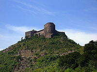 The fort, as such, within the city limits was constructed in 1731 at the port near the land end facing the bay, built under the directive of Louis XV, King of France, in order to defend against invasions. Fort-Liberté is on the southern shore of the bay. It is about 0.5 mile (0.80467 km) north from the city centre. The shoal in front of the fort is steep and extends to about 20 yard. Now, only the fort ruins are seen as evidence of the ingenious design of the architects who selected the most strategic point on the island to build it overlooking the turquoise blue ocean waters. However, efforts have been made during the middle of 1990s to restore the fort and the structures within it. Pilferage has seen the loss of the cannons and the cannon balls, apart from removal of stones imported from Nantes
, France for pecuniary benefits without realising the gravity of the vandalism act. An issue of concern is the appearance of fissures in the fort walls, which are endangering the protection of forts from rains.
The fort has a colonial cathedral, which is now the renovated entrance to the city. It is called the "Belle Entrée(Beautiful Gate). In the vicinity, other forts are the Fort la Bouque
, the Batterie de l'Anse, the Fort Saint Charles and the Fort Saint Frédérique. Bayau Island is also another important place.
The Ministry of Tourism, the Ministry of Culture, the Haitian representatives and the Royal Caribbean officials have launched a project to encourage tourism to Fort-Liberté and its fort and Port-au-Prince
by building facilities of hotels and other infrastructure.
plantation until nylon
was invented. From the time of colonization, the economy of the island has been essentially agriculture centric. Plantation tillage has been the main occupation which encompasses sugar-cane, coffee, cocoa, and cotton. In 1789, in the French part of the island there were 793 sugar plantations, 3,117 coffee plantations, 789 cotton plantations, and 182 establishments for making rum, besides other minor factories and workshops. In 1791, investments were largely oriented towards these cultivations. Trade and economy of the city and its precincts, at present are – coffee
, cacao, honey
, logwood
, pineapple
, and sisal, which are the principal products.
 History of Haiti has a tumultuous past. The antislave movement is traced to the Cap-Haïtien
(also spelt ‘cap’ or ‘o’ Kap). Cap Haiten derives its name from the 3 metres (9.8 ft) high cape on the south-eastern side. It is Haiti's second biggest city – once one of the richest colonial ports in the world laid out in a square grid pattern. It was the capital of the colonial times when it was known as Cap Français, called the "Paris of the Antilles". It was the biggest port (called the mother of all ports) in the north and commercial centre of the northern plains, the biggest sugar-producing region. The city was torched three times, during 1734, 1798 and 1802, the last time by Christopher to prevent it falling into the hands of the French. It was destroyed again by an earthquake in 1842 when more than half its population perished. The city is now influenced by Spanish architecture with barrel tile roofs, porches, arcades and interior courtyards. A castle perched on a hill Fort Lierte is to the east part of France's was a futile effort to keep hold of its colony. Independence was declared in Gonaïves
on the road back to Port-au-Prince. To the west lies the Isle de lau Tortue (Tortuga (Haiti) Island) known for its pirate adventurers. The city retains a parochial and relaxed atmosphere. The sugar plantation named Habitation Le Normand de Mezy known for the many slave labourers who worked on the plantations is located 8 kilometres (5 mi) southwest of Cap. It has ruins of two aqueducts and walls to its west, near the town of Plaine Du Nord.
Bois Caïman
(Haitian Creole: Bwa Kayiman), 3 kilometres (1.9 mi) south of road RN 1, is the village where Vodoo rites were performed under a tree. This was the venue where Dutty Boukman
(a magician) held the first antislavery movement secretly on August 14, 1791 and a Vodoo, a planned uprising ceremony, was also performed. Haiti's famous antislave leader African chief's son was Mackandal called Dutty Boukman who became an Houngan
and led a brigand of maroons. Following this rite, the insurrection was started on the night of August 22–23, 1791. He terrorized the northern plain area by poisoning food and water. He was captured and burned alive in January 1758. Another leader who followed Boukman was Jean-François. This was the beginning of the uprising by the slaves, which is said to be the Haitian equivalent of the storming of the Bastille
. During this uprising, the plantation and cane fields were torched and French settlers were massacred. This was a successful revolt that led to the independence of Haiti. The place is now identified only by a ficus
tree. Adjoining it is a colonial well, which is credited with mystic powers.
Vertières
Vertières is an outlying district on the Port-au-Prince Road where French were defeated by Dessalines
army on November 18, 1803 in the Battle of Vertières
. French left the place after 12 days and a monument erected here records the historic event. It is very ill maintained town with no municipal facilities with hardly any semblance of municipal administration. To the south and east of the Cap, there were thousand plantation houses of the colonial period.
Beaches in Cap
Beaches in Cap are good but maintained badly – Cormeier Plage and Labadee are the well-known beaches. Labadee
(also Labadie) is a port and a beach located on the northern coast of Haiti. It is a private resort leased to the Royal Caribbean International
. Belli Beach is a small sandy cove with boats and hotels. Labadie village could be visited from here.
Morne Rouge
Morne Rouge is 8 kilometres (5 mi) to the south of Cap. It is the "Habitation Le Normand de Mezy", a sugar plantation known for the several slaves who led rebellion against the French.
.jpg) The town of Plaine-du-Nord
The town of Plaine-du-Nord
, 12 kilometres (7.5 mi) southwest of Cap is a pilgrimage centre where a Catholic festival of St James who is linked to Ogou is held on 24–25 July. People from all over Haiti camp here on the road celebrating by continuous drumming and dancing. The revellers then move on to Limonade
, 15 kilometres (9.3 mi) south west of Cap for another night of celebrations.
Nord-Est Department
Nord-Est is one of the ten departments of Haiti. It has an area of 1,805 km² and a population of 283,800 . Its capital is Fort-Liberté. It used to be part of Nord Department...
, Haiti
Haiti
Haiti , officially the Republic of Haiti , is a Caribbean country. It occupies the western, smaller portion of the island of Hispaniola, in the Greater Antillean archipelago, which it shares with the Dominican Republic. Ayiti was the indigenous Taíno or Amerindian name for the island...
. It is close to the border of the Dominican Republic
Dominican Republic
The Dominican Republic is a nation on the island of La Hispaniola, part of the Greater Antilles archipelago in the Caribbean region. The western third of the island is occupied by the nation of Haiti, making Hispaniola one of two Caribbean islands that are shared by two countries...
and is one of the oldest cities in the country. Haiti's independence was proclaimed here on November 29, 1803. The area around Fort-Liberté was originally inhabited by Indians
Indigenous peoples of the Americas
The indigenous peoples of the Americas are the pre-Columbian inhabitants of North and South America, their descendants and other ethnic groups who are identified with those peoples. Indigenous peoples are known in Canada as Aboriginal peoples, and in the United States as Native Americans...
, and later by colonists, starting with the Spanish. It was founded as a city in 1578 by the French, was occupied by the British in 1790, captured
Capture of Fort-Dauphin (1794)
The Capture of Fort-Dauphin was a bloodless encounter of the French Revolutionary Wars on which a Spanish expedition under Gabriel de Aristizábal seized Fort-Liberté, then named Fort-Dauphin, from Revolutionary France...
by the Spanish forces in 1794 and restored to the French in 1801 until independence in 1803. The city has undergone a succession of name changes, in the order of Bayaha (1578), Fort-Dauphin (1732), Fort St. Joseph (1804), Fort-Royal (1811) and finally as Fort-Liberté since 1820. The town is part of the Roman Catholic Diocese of Fort-Liberté
Roman Catholic Diocese of Fort-Liberté
The Roman Catholic Diocese of Fort-Liberté is a suffragan of the Archdiocese of Cap-Haïtien.-External links and references:...
.
Demographics and social norms
Population of Fort-Liberté is 11,465. The Haitian Creole languageHaitian Creole language
Haitian Creole language , often called simply Creole or Kreyòl, is a language spoken in Haiti by about twelve million people, which includes all Haitians in Haiti and via emigration, by about two to three million speakers residing in the Bahamas, Cuba, Canada, France, Cayman Islands, French...
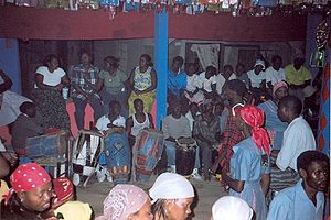
is spoken in this area with the more educated speaking French. Religion is Roman Catholic and Haitian Vodou. Educational institutions have been established from time to time in various parts of the island.
Geography
Fort-Liberté is part of Nord-Est DepartmentNord-Est Department
Nord-Est is one of the ten departments of Haiti. It has an area of 1,805 km² and a population of 283,800 . Its capital is Fort-Liberté. It used to be part of Nord Department...
, which borders the Dominican Republic. Nord-Est (North-East) is one of the ten departments (départements) of Haiti
Departments of Haiti
The Communes of Haiti are the third-level divisions of Haiti. The 10 departments have 42 arrondissements which are divided into 140 communes.-Artibonite Department:*Dessalines Arrondissement**Desdunes**Dessalines**Grande Saline...
. Nord-Est has an area of 1805 square kilometre and a population of 283,800 (2002). The arrondissement
Arrondissement
Arrondissement is any of various administrative divisions of France, certain other Francophone countries, and the Netherlands.-France:The 101 French departments are divided into 342 arrondissements, which may be translated into English as districts. The capital of an arrondissement is called a...
consists of the three municipalities of Fort-Liberté, Ferrier
Ferrier, Nord-Est
Ferrier is a municipality in the Fort-Liberté Arrondissement, in the Nord-Est Department of Haiti.It has 13,096 inhabitants....
and Perches
Perches, Nord-Est
Perches is a municipality in the Fort-Liberté Arrondissement, in the Nord-Est Department of Haiti.It has 8,344 inhabitants....
. In the colonial era, it was a major plantation area and remains an important coffee producing area. Its pine forests are heavily exploited for charcoal. In addition, several era colonial forts, mostly in ruins, are situated here.
Fort-Liberté is a natural harbour of the Saint Domingue. It is strategically located in the centre of the bay facing the Atlantic Ocean. It was once a strategic naval base of the French, which was established by them in 1731. The town was militarily fortified by the French with four fort structural bases that "guarded the bay like beads on a string." Two of the larger forts are Fort Lachatre and Fort Labourque
Labourque
Fort la Bouque is one of three colonial forts in the North East area of Haiti or more specifically the Arrondissement of Fort-Liberte. The fort is located at the following coordinates Fort-Liberté is Chef Lieu of the North East Department and its own Arrondissement by the same name...
. The fort was captured by Toussaint Louverture (May 20, 1743 – April 7, 1803), the leader of the Haitian Revolution
Haitian Revolution
The Haitian Revolution was a period of conflict in the French colony of Saint-Domingue, which culminated in the elimination of slavery there and the founding of the Haitian republic...
, in 1793 who later proceeded to the north and conquered the Spanish. Its historic importance is also because it served as the antislavery movement that started here. Now, it is an economically weak territory.
The fort is 40 nautical miles (74.1 km) from Port-de-Paix
Port-de-Paix
Port-de-Paix is a city and the capital of the département of Nord-Ouest in Haïti on the Atlantic coast. It has a population of 250,000 ....
(the capital of the Nord-Ouest Department) and290 kilometres (180.2 mi) from Port-au-Prince
Port-au-Prince
Port-au-Prince is the capital and largest city of the Caribbean nation of Haiti. The city's population was 704,776 as of the 2003 census, and was officially estimated to have reached 897,859 in 2009....
(capital of Haiti). The average elevation of the town is about1 metres (3.3 ft).
Fort-Liberté Bay
The coast line between Fort-Liberté Bay and Point Yaquezi is about 8 miles (12.9 km). It has a low sandy beach. It has reefs with mangrove forests, and two hills (spaced at 0.5 mile (0.80467 km)) about 3.5 miles (5.6 km) to the west of the entrance to the bay. The hills are the markers for the entrance to the port. Land locked, Fort-Liberté Bay is spread over a length of5 miles (8 km) in the east west direction and has a breadth of about of 1 miles (1.6 km). The shallow waters that extends to 1 miles (1.6 km) provides for adequate draft and safe anchorage conditions. The entrance to the fort is stated to be "about 1.25 miles (2 km) long with not less than 15 fathoms depth of water in the fairway but is narrow and tortuous, so that a sailing vessel entering requires the wind to be well to the northward of east, and its leaving must have a commanding land breeze." The coast line from the entrance to the bay extends to 6.5 miles (10.5 km) in an easterly direction extending to Manzanillo Bay. There is no wharf. The tides are high – spring rise is 5.75 feet (1.8 m) and neap is 3.5 feet (1.1 m). Vessels anchor at the port in 12 fathoms deep water which provides manoeuvring space of 600 yard on the east and northeast direction of the Bayon Islet, which is in the midst of the bay. Another anchorage point with 9 fathoms depth is found to the east of the fort. The tidal current at the entrance is said to be low in the morning hours when it is the best time to enter the port.Fresh water resource
Marion River empties into the bay about 1 miles (1.6 km) to the west of the Fort-Liberté and is the source of water supply to the town.Climate
The city has a pleasant climate with a cool ocean breeze and an average temperature of 86 °F (30 °C). Hispionala island as a whole is subject to varying weather changes, which result in severe storms such as hurricanes and sunshine. It is the typical intensity of tropical climate which exasperates the natives.History
Nicolás de Ovando
Fray Nicolás de Ovando y Cáceres was a Spanish soldier from a noble family and a Knight of the Order of Alcántara. He was Governor of the Indies from 1502 until 1509...
, Spanish governor
Governor
A governor is a governing official, usually the executive of a non-sovereign level of government, ranking under the head of state...
of Hispaniola
Hispaniola
Hispaniola is a major island in the Caribbean, containing the two sovereign states of the Dominican Republic and Haiti. The island is located between the islands of Cuba to the west and Puerto Rico to the east, within the hurricane belt...
, founded the town of Puerto Real
Puerto Real
Puerto Real is a seaport in southern Spain, in the province of Cádiz and the autonomous region of Andalusia. , it had a population 40,667....
("Royal Port"), which today lies around the town of Caracol, to the west of Fort-Liberté. However, soon this town was abandoned and the people moved to the east and in 1578 a new town was founded with the Taíno
Taíno people
The Taínos were pre-Columbian inhabitants of the Bahamas, Greater Antilles, and the northern Lesser Antilles. It is thought that the seafaring Taínos are relatives of the Arawak people of South America...
name of the region, Bayajá. Caracol was thought to be near the location where Santa Maria, Columbus's flagship struck a reef and sank on Christmas Day in 1492. The shipwreck was salvaged for its wood to build settlements known as La Navidad
La Navidad
La Navidad was a settlement that Christopher Columbus and his men established in present day Haiti in 1492 from the remains of the Spanish ship, the Santa María...
, which was decimated by Taino Indians after Columbus left the place. This was discovered by the American Archaeologist William Hodges
William Hodges
William Hodges RA was an English painter. He was a member of James Cook's second voyage to the Pacific Ocean, and is best known for the sketches and paintings of locations he visited on that voyage, including Table Bay, Tahiti, Easter Island, and the Antarctic.Hodges was born in London. He was a...
while excavating at Puerto Real, a city founded at the same spot years later. Relics gathered from this site are displayed at museum Limbe
Limbé Arrondissement
Limbé is an arrondissement in the Nord Department of Haiti.It has 84,951 inhabitants.Postal codes in the Limbé Arrondissement start with the number 16.The arondissement consists of the following municipalities:* Limbé* Bas-Limbé...
. However, no trace of the site is visible at the location.
In 1606, the persons living in the old Spanish towns of Bayajá and Yaguana under the orders of the Spanish king, moved to the eastern part of the island, to a new town called Bayaguana
Bayaguana
Bayaguana is a municipality of the Monte Plata province in the Dominican Republic.As of the Dominican Republic's 2002 census, the municipality had a total population of 33,122 inhabitants, of which 19,351 resided in urban areas and 13,771 in rural areas.Bayaguana was founded in 1606, when Spain...
, combining the two old names. Thus, the Spaniards founded the city of Bayaha, now known as Fort-Liberté, one of the several towns of Hispaniola. It bore other names such as the Fort–Royal and Fort Dauphin. The location became the historic site of Fort-Liberté as it was built in 1731 under the orders of Louis XV, King of France. Successive changes happened in the naming of the town reflecting the shift of power from Spanish to French colonization. The town was witness to the Haiti's first declaration of independence on November 29, 1803.
Fort
Nantes
Nantes is a city in western France, located on the Loire River, from the Atlantic coast. The city is the 6th largest in France, while its metropolitan area ranks 8th with over 800,000 inhabitants....
, France for pecuniary benefits without realising the gravity of the vandalism act. An issue of concern is the appearance of fissures in the fort walls, which are endangering the protection of forts from rains.
The fort has a colonial cathedral, which is now the renovated entrance to the city. It is called the "Belle Entrée(Beautiful Gate). In the vicinity, other forts are the Fort la Bouque
Labourque
Fort la Bouque is one of three colonial forts in the North East area of Haiti or more specifically the Arrondissement of Fort-Liberte. The fort is located at the following coordinates Fort-Liberté is Chef Lieu of the North East Department and its own Arrondissement by the same name...
, the Batterie de l'Anse, the Fort Saint Charles and the Fort Saint Frédérique. Bayau Island is also another important place.
The Ministry of Tourism, the Ministry of Culture, the Haitian representatives and the Royal Caribbean officials have launched a project to encourage tourism to Fort-Liberté and its fort and Port-au-Prince
Port-au-Prince
Port-au-Prince is the capital and largest city of the Caribbean nation of Haiti. The city's population was 704,776 as of the 2003 census, and was officially estimated to have reached 897,859 in 2009....
by building facilities of hotels and other infrastructure.
Economy
The bay was the site of Caribbean's largest sisalSisal
Sisal is an agave that yields a stiff fibre traditionally used in making twine, rope and also dartboards. The term may refer either to the plant or the fibre, depending on context...
plantation until nylon
Nylon
Nylon is a generic designation for a family of synthetic polymers known generically as polyamides, first produced on February 28, 1935, by Wallace Carothers at DuPont's research facility at the DuPont Experimental Station...
was invented. From the time of colonization, the economy of the island has been essentially agriculture centric. Plantation tillage has been the main occupation which encompasses sugar-cane, coffee, cocoa, and cotton. In 1789, in the French part of the island there were 793 sugar plantations, 3,117 coffee plantations, 789 cotton plantations, and 182 establishments for making rum, besides other minor factories and workshops. In 1791, investments were largely oriented towards these cultivations. Trade and economy of the city and its precincts, at present are – coffee
Coffee
Coffee is a brewed beverage with a dark,init brooo acidic flavor prepared from the roasted seeds of the coffee plant, colloquially called coffee beans. The beans are found in coffee cherries, which grow on trees cultivated in over 70 countries, primarily in equatorial Latin America, Southeast Asia,...
, cacao, honey
Honey
Honey is a sweet food made by bees using nectar from flowers. The variety produced by honey bees is the one most commonly referred to and is the type of honey collected by beekeepers and consumed by humans...
, logwood
Logwood
Haematoxylum campechianum is a species of flowering tree in the legume family, Fabaceae, that is native to southern Mexico and northern Central America. It has been and to a lesser extent remains of great economic importance. The modern nation of Belize grew from 17th century English logwood...
, pineapple
Pineapple
Pineapple is the common name for a tropical plant and its edible fruit, which is actually a multiple fruit consisting of coalesced berries. It was given the name pineapple due to its resemblance to a pine cone. The pineapple is by far the most economically important plant in the Bromeliaceae...
, and sisal, which are the principal products.
Other historical places of interest in the vicinity
Haiti island has many historic cities linked to the turbulent historic events which evolved in both parts of Haiti namely, the eastern part under the Spaniards and the west and south with the French. Some of the most prominent towns, villages and historical sites are the following.Cap-Haïtien
Cap-Haïtien
Cap-Haïtien is a city of about 190,000 people on the north coast of Haiti and capital of the Department of Nord...
(also spelt ‘cap’ or ‘o’ Kap). Cap Haiten derives its name from the 3 metres (9.8 ft) high cape on the south-eastern side. It is Haiti's second biggest city – once one of the richest colonial ports in the world laid out in a square grid pattern. It was the capital of the colonial times when it was known as Cap Français, called the "Paris of the Antilles". It was the biggest port (called the mother of all ports) in the north and commercial centre of the northern plains, the biggest sugar-producing region. The city was torched three times, during 1734, 1798 and 1802, the last time by Christopher to prevent it falling into the hands of the French. It was destroyed again by an earthquake in 1842 when more than half its population perished. The city is now influenced by Spanish architecture with barrel tile roofs, porches, arcades and interior courtyards. A castle perched on a hill Fort Lierte is to the east part of France's was a futile effort to keep hold of its colony. Independence was declared in Gonaïves
Gonaïves
Gonaïves is a city in northern Haiti, the capital of the Artibonite Department. It has a population of about 104,825 people . The city's name derives from the original Amerindian name of Gonaibo. It is also known as Haïti's "independence city"...
on the road back to Port-au-Prince. To the west lies the Isle de lau Tortue (Tortuga (Haiti) Island) known for its pirate adventurers. The city retains a parochial and relaxed atmosphere. The sugar plantation named Habitation Le Normand de Mezy known for the many slave labourers who worked on the plantations is located 8 kilometres (5 mi) southwest of Cap. It has ruins of two aqueducts and walls to its west, near the town of Plaine Du Nord.
Bois Caïman and Vodoo
Bois Caïman
Bois Caïman
Bois Caïman is the site of the Vodou ceremony presided over by Dutty Boukman on August 14, 1791. The stated purpose of the ritual was to attempt to overthrow French rule, which was based on slave labor....
(Haitian Creole: Bwa Kayiman), 3 kilometres (1.9 mi) south of road RN 1, is the village where Vodoo rites were performed under a tree. This was the venue where Dutty Boukman
Dutty Boukman
Dutty Boukman ' was a Jamaican born houngan, or Haitian priest who conducted a religious ceremony in Haiti in which a freedom covenant was affirmed; this ceremony is considered a catalyst to the slave uprising that marked the beginning of the Haïtian Revolution.-Background:Boukman Dutty was a self...
(a magician) held the first antislavery movement secretly on August 14, 1791 and a Vodoo, a planned uprising ceremony, was also performed. Haiti's famous antislave leader African chief's son was Mackandal called Dutty Boukman who became an Houngan
Houngan
Houngan is the term for a male priest in the voodoo religion in Haiti . The term is derived from the Fon word "hùn gan". There are two ranks of houngan, houngan asogwe and houngan sur pwen...
and led a brigand of maroons. Following this rite, the insurrection was started on the night of August 22–23, 1791. He terrorized the northern plain area by poisoning food and water. He was captured and burned alive in January 1758. Another leader who followed Boukman was Jean-François. This was the beginning of the uprising by the slaves, which is said to be the Haitian equivalent of the storming of the Bastille
Storming of the Bastille
The storming of the Bastille occurred in Paris on the morning of 14 July 1789. The medieval fortress and prison in Paris known as the Bastille represented royal authority in the centre of Paris. While the prison only contained seven inmates at the time of its storming, its fall was the flashpoint...
. During this uprising, the plantation and cane fields were torched and French settlers were massacred. This was a successful revolt that led to the independence of Haiti. The place is now identified only by a ficus
Ficus
Ficus is a genus of about 850 species of woody trees, shrubs, vines, epiphytes, and hemiepiphyte in the family Moraceae. Collectively known as fig trees or figs, they are native throughout the tropics with a few species extending into the semi-warm temperate zone. The Common Fig Ficus is a genus of...
tree. Adjoining it is a colonial well, which is credited with mystic powers.
Vertières
Vertières is an outlying district on the Port-au-Prince Road where French were defeated by Dessalines
Dessalines
Dessalines can refer to:* Jean-Jacques Dessalines, a general and statesman of Haiti.** La Dessalinienne, the national anthem of Haiti named in his honor.** Arrondissement of Dessalines, a Haitian arrondissement in the Artibonite Department...
army on November 18, 1803 in the Battle of Vertières
Battle of Vertières
The Battle of Vertières , the last major battle of the Second War of Haitian Independence, the final part of the Haitian Revolution under François Capois. It was fought between Haitian rebels and French expeditionary forces on 18 November 1803 at Vertières...
. French left the place after 12 days and a monument erected here records the historic event. It is very ill maintained town with no municipal facilities with hardly any semblance of municipal administration. To the south and east of the Cap, there were thousand plantation houses of the colonial period.
Beaches in Cap
Beaches in Cap are good but maintained badly – Cormeier Plage and Labadee are the well-known beaches. Labadee
Labadee
Labadee is a port located on the northern coast of Haiti. It is a private resort leased to Royal Caribbean International. Royal Caribbean International has contributed the largest proportion of tourist revenue to Haiti since 1986, employing 300 locals, allowing another 200 to sell their wares on...
(also Labadie) is a port and a beach located on the northern coast of Haiti. It is a private resort leased to the Royal Caribbean International
Royal Caribbean International
Royal Caribbean International is a Norwegian and American cruise line brand based in Miami, Florida and owned by Royal Caribbean Cruises Ltd.. With 42 ships in service under 5 different brands and one more under construction, it controls a 25.6% share of the world cruise market...
. Belli Beach is a small sandy cove with boats and hotels. Labadie village could be visited from here.
Morne Rouge
Morne Rouge is 8 kilometres (5 mi) to the south of Cap. It is the "Habitation Le Normand de Mezy", a sugar plantation known for the several slaves who led rebellion against the French.
Plaine Du Nord
Plaine-du-Nord
Plaine-du-Nord is a municipality in the Acul-du-Nord Arrondissement, in the Nord Department of Haiti.It has 28,544 inhabitants....
, 12 kilometres (7.5 mi) southwest of Cap is a pilgrimage centre where a Catholic festival of St James who is linked to Ogou is held on 24–25 July. People from all over Haiti camp here on the road celebrating by continuous drumming and dancing. The revellers then move on to Limonade
Limonade
Limonade is a municipality in the Cap-Haïtien Arrondissement, in the Nord Department of Haiti.It has 69,256 inhabitants. Christopher Columbus and his crew celebrated the first Christmas in the Americas at Limonade in 1492. Limonade is also the city in which François Capois, a renowned hero of the...
, 15 kilometres (9.3 mi) south west of Cap for another night of celebrations.