

Formartine and Buchan Way
Encyclopedia
Scotland
Scotland is a country that is part of the United Kingdom. Occupying the northern third of the island of Great Britain, it shares a border with England to the south and is bounded by the North Sea to the east, the Atlantic Ocean to the north and west, and the North Channel and Irish Sea to the...
, extending from Dyce
Dyce
Dyce is a civil parish and suburb of Aberdeen, Scotland, about north west of Aberdeen city centre, and best known as the location of the city's airport. It is on the River Don.- History :...
north to Peterhead
Peterhead
Peterhead is a town in Aberdeenshire, Scotland. It is Aberdeenshire's biggest settlement , with a population of 17,947 at the 2001 Census and estimated to have fallen to 17,330 by 2006....
and Fraserburgh
Fraserburgh
Fraserburgh is a town in Aberdeenshire, Scotland with a population recorded in the 2001 Census at 12,454 and estimated at 12,630 in 2006. It lies at the extreme northeast corner of Aberdeenshire, around north of Aberdeen, and north of Peterhead...
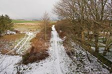
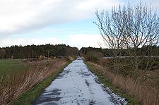
. It follows the track of a former railway line, the Formartine and Buchan Railway
Formartine and Buchan Railway
The Formartine and Buchan Railway was a railway in the north east of Scotland. It was built to link Fraserburgh and Peterhead with Aberdeen. It had a junction with the main line of the Great North of Scotland Railway at Dyce.-History:...
, and is open to walkers and cyclists. Horse riders are also welcome on parts of the track but may require a permit. The railway closed in 1979 (Fraserburgh) and 1970 (Maud-Peterhead). The walkway opened in the early 1990s.
Accessibility
The path is around 53 miles (85.3 km) long and can be accessed relatively easily by public transport or car. Only the Maud station is less accessible by bus. A map of the Formatine and Buchan way is no longer available from local tourist offices, but it is marked on OSOrdnance Survey
Ordnance Survey , an executive agency and non-ministerial government department of the Government of the United Kingdom, is the national mapping agency for Great Britain, producing maps of Great Britain , and one of the world's largest producers of maps.The name reflects its creation together with...
maps.
Route
The path starts at DyceDyce
Dyce is a civil parish and suburb of Aberdeen, Scotland, about north west of Aberdeen city centre, and best known as the location of the city's airport. It is on the River Don.- History :...
which is on the outskirts of Aberdeen
Aberdeen
Aberdeen is Scotland's third most populous city, one of Scotland's 32 local government council areas and the United Kingdom's 25th most populous city, with an official population estimate of ....
City. It passes to the east of Newmachar
Newmachar
Newmachar is a village in the north-east of Scotland located within the Aberdeenshire local authority. Situated 10 miles to the north-west of Aberdeen, the settlement has an estimated population of 2,400.-Overview:...
and through Udny Station
Udny Station
Udny Station is a small village in Aberdeenshire, Scotland which is 5 miles east of Oldmeldrum and 5 miles south west of Ellon. It is part of the parish of Udny, along with another small settlement, Udny Green....
before reaching Ellon
Ellon, Aberdeenshire
Ellon is a town in Aberdeenshire, Scotland, approximately north of Aberdeen, lying on the River Ythan which has one of the few undeveloped river estuaries on the Eastern coast of Scotland. It is in the ancient region of Formartine...
after 13 miles (20.9 km). It continues north through Auchnagatt
Auchnagatt
Auchnagatt is a village and rural area in Buchan, Aberdeenshire, Scotland, situated on the Ebrie Burn and on the A948 road between Ellon and New Deer.- Schools :...
before reaching the crossroads of Maud
Maud, Aberdeenshire
Maud is a small town in the Buchan area of the Scottish county of Aberdeenshire. Population 780 . Located 13 miles west of Peterhead on the South Ugie Water, Maud rose to prosperity in the nineteenth century as a railway junction of the Formartine and Buchan Railway that ran through Maud to...
. The Ellon to Maud section is 12.5 miles (20.1 km) long. At Maud the Way goes east to Peterhead
Peterhead
Peterhead is a town in Aberdeenshire, Scotland. It is Aberdeenshire's biggest settlement , with a population of 17,947 at the 2001 Census and estimated to have fallen to 17,330 by 2006....
and north to Fraserburgh
Fraserburgh
Fraserburgh is a town in Aberdeenshire, Scotland with a population recorded in the 2001 Census at 12,454 and estimated at 12,630 in 2006. It lies at the extreme northeast corner of Aberdeenshire, around north of Aberdeen, and north of Peterhead...
It is 13 miles (20.9 km) to Peterhead and 15.5 to Fraserburgh.
Places of interest
Places of interest along the way include Drinnes Wood Observatory, Strichen Stone CircleStrichen Stone Circle
Strichen Stone Circle is a small Megalithic period stone circle located in the north east of Scotland, near to Strichen, Aberdeenshire.The circle has been destroyed at least twice: once by a tenant farmer who was ordered to put it back in place by his landlord.It has been restored as recently as...
, Aden Country Park
Aden Country Park
Aden Country Park is located in Mintlaw, Aberdeenshire, Scotland. The park has a caravan area with camping, a small shop, a small cafe near the agricultural museum, a play area, a nature garden and a barbecue area. Aden Park can be accessed from Mintlaw by Station Road or Nether Aden Road.It is...
, Deer Abbey
Deer Abbey
Deer Abbey was a Cistercian monastery in Buchan, Scotland. It was founded by 1219 AD with the patronage William Comyn, jure uxoris Earl of Buchan, who is also buried there. There was an earlier community of Scottish monks or priests...
and The White Horse at Strichen.
Signage and condition of way
The path is well signposted and is easy to follow. The track is relatively flat and undulates only when roads have to be crossed. It is well maintained, and few parts are overgrown. However, the Maud to Strichen section has a detour because of overgrown shrubbery, marshy conditions and numerous problems such as gates and fences blocking access.Users
Many cyclists use the way as a commuting route into Dyce, Fraserburgh and Peterhead. Dog walkers are also a common sight.Related local railway walks
Many walkers and cyclists in the local area also use the Deeside WayDeeside Way
The Deeside Way , is a pathway that travels along the bed of the now removed Deeside Railway, along the north bank of the River Dee in Aberdeenshire.While in operation, the railway was used by the British Royal Family during travel to their Scottish retreat at Balmoral,...
. It is open between Aberdeen and Culter and has recently been extended to Banchory
Banchory
Banchory is a burgh or town in Aberdeenshire, Scotland, lying approximately 18 miles west of Aberdeen, near where the Feugh River meets the River Dee.- Overview :...
using a mix of minor roads and railway track.
Closure of the railway and proposal for re-opening
The Peterhead-Maud section of the railway closed in 1970. The Dyce-Fraserburgh route closed as late as 1979. This closure was particularly controversial. The closure happened just as the oil boom was taking off and housing in towns like Ellon in particular was taking off. Ellon has 50% more inhabitants now than in 1979, and the lack of a Buchan Railway leads to terrible traffic problems on the A90A90 road
The A90 road is a major north to south road in eastern Scotland, running from Edinburgh to Fraserburgh in Aberdeenshire.From Edinburgh, it travels west and over the Forth Road Bridge, before turning into the M90 motorway. At Perth, the M90 again becomes the A90, now running north east to Dundee...
.
Transport Scotland is accessing the Aberdeen Crossrail
Aberdeen Crossrail
Aberdeen Crossrail is a proposed railway development in north-east Scotland, first proposed within the 2003 Scottish Strategic Rail Study. It is supported by NESTRANS the north-east's voluntary regional transport partnership....
project with through trains from Stonehaven to Inverurie. Part of the scope of this is to consider the re-opening of sections of the Buchan line. The cost is estimated to £400 million, a comparatively small amount compared to many roadbuilding schemes.
External links
- Formartine and Buchan Way guide and mapping on Walkhighlands
- Aberdeenshire Council's F & BW website
- Tourist info on the Way
- Information about the former railway