

Maud, Aberdeenshire
Encyclopedia
Buchan
Buchan is one of the six committee areas and administrative areas of Aberdeenshire Council, Scotland. These areas were created by the council in 1996, when the Aberdeenshire unitary council area was created under the Local Government etc Act 1994...
area of the Scottish
Scotland
Scotland is a country that is part of the United Kingdom. Occupying the northern third of the island of Great Britain, it shares a border with England to the south and is bounded by the North Sea to the east, the Atlantic Ocean to the north and west, and the North Channel and Irish Sea to the...
county of Aberdeenshire
Aberdeenshire
Aberdeenshire is one of the 32 unitary council areas in Scotland and a lieutenancy area.The present day Aberdeenshire council area does not include the City of Aberdeen, now a separate council area, from which its name derives. Together, the modern council area and the city formed historic...
. Population 780 (2006 estimate). Located 13 miles west of Peterhead
Peterhead
Peterhead is a town in Aberdeenshire, Scotland. It is Aberdeenshire's biggest settlement , with a population of 17,947 at the 2001 Census and estimated to have fallen to 17,330 by 2006....
on the South Ugie Water
South Ugie Water
The South Ugie Water is a tributary of the Ugie Water in northeastern Aberdeenshire, Scotland. To the south of the Ugie Water are a number of prehistoric monuments, evidencing the habitation of early man in the northeast of Scotland; for example, the Catto Long Barrow and a number of tumuli are...
, Maud rose to prosperity in the nineteenth century as a railway junction of the Formartine and Buchan Railway
Formartine and Buchan Railway
The Formartine and Buchan Railway was a railway in the north east of Scotland. It was built to link Fraserburgh and Peterhead with Aberdeen. It had a junction with the main line of the Great North of Scotland Railway at Dyce.-History:...
that ran through Maud to Fraserburgh and Peterhead, but has always been the meeting place of six roads. It has had a variety of names:
- Bank of Behitch
- Brucklay
- New Maud
the 'New' falling out of use leading to its current name.
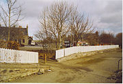
The Village
Maud features an old railway station, which closed to passengers in 1965. Walks can be taken along the old railway lines; the railway tracks were removed following the ending of freight trains in 1979. There was a mart or livestock market until recently, selling local livestock. There is also a hospital for the elderly, which was formerly a poorhousePoorhouse
A poorhouse or workhouse was a government-run facility in the past for the support and housing of dependent or needy persons, typically run by a local government entity such as a county or municipality....
that opened in about 1868.
History
The local area to the immediate south is rich with prehistoryPrehistory
Prehistory is the span of time before recorded history. Prehistory can refer to the period of human existence before the availability of those written records with which recorded history begins. More broadly, it refers to all the time preceding human existence and the invention of writing...
and historical features. There are found a number of prehistoric monuments including Catto Long Barrow
Catto Long Barrow
Catto Long Barrow is a prehistoric site in Aberdeenshire, Scotland. The site is known locally as Cairn Catto. The extant monument extends for a length of 49 metres.-References:* United Kingdom Ordnance Survey Map 1:50,000 scale, Landranger series...
, Silver Cairn and numerous tumuli. In that same vicinity of the Laeca Burn
Laeca Burn
Laeca Burn is a stream in northeastern Aberdeenshire, Scotland. There are numerous archaeological sites in the Laeca Burn watershed, "especially on the eastern side of Laeca Burn", where Catto Long Barrow is situated.-References:...
watershed is the point d'appui
Point d'appui
A point d'appui, in military theory, is a location where troops are assembled prior to a battle. Often a monument is erected to commemorate the point d'appui for notable battles...
of historic battles between invading Danes and indigenous Pict
PICT
PICT is a graphics file format introduced on the original Apple Macintosh computer as its standard metafile format. It allows the interchange of graphics , and some limited text support, between Mac applications, and was the native graphics format of QuickDraw.The original version, PICT 1, was...
s.
In the era of the railroad, the New Maud junction station was situated 298 feet above sea level, with the vicinity rail line being noted for several embankments and shallow rock cuts.