

Deeside Way
Encyclopedia
Trail
A trail is a path with a rough beaten or dirt/stone surface used for travel. Trails may be for use only by walkers and in some places are the main access route to remote settlements...
that travels along the bed of the now removed Deeside Railway, along the north bank of the River Dee
River Dee, Aberdeenshire
The River Dee is a river in Aberdeenshire, Scotland. It rises in the Cairngorms and flows through Strathdee to reach the North Sea at Aberdeen...
in Aberdeenshire
Aberdeenshire
Aberdeenshire is one of the 32 unitary council areas in Scotland and a lieutenancy area.The present day Aberdeenshire council area does not include the City of Aberdeen, now a separate council area, from which its name derives. Together, the modern council area and the city formed historic...
.
While in operation, the railway was used by the British Royal Family
British Royal Family
The British Royal Family is the group of close relatives of the monarch of the United Kingdom. The term is also commonly applied to the same group of people as the relations of the monarch in her or his role as sovereign of any of the other Commonwealth realms, thus sometimes at variance with...
during travel to their Scottish retreat at Balmoral
Balmoral Castle
Balmoral Castle is a large estate house in Royal Deeside, Aberdeenshire, Scotland. It is located near the village of Crathie, west of Ballater and east of Braemar. Balmoral has been one of the residences of the British Royal Family since 1852, when it was purchased by Queen Victoria and her...
, hence the local name the Royal Deeside Line.
Deeside Railway
The Deeside Railway was a line that travelled from AberdeenAberdeen
Aberdeen is Scotland's third most populous city, one of Scotland's 32 local government council areas and the United Kingdom's 25th most populous city, with an official population estimate of ....
to Ballater
Ballater
Ballater is a burgh in Aberdeenshire, Scotland on the River Dee, immediately east of the Cairngorm Mountains. Situated at a height of 123m in elevation, Ballater is a centre for hikers and known for its spring water, once said to cure scrofula.-History:The medieval pattern of development along...
as a stretch of the Great North of Scotland Railway
Great North of Scotland Railway
The Great North of Scotland Railway was one of the smaller Scottish railways before the grouping, operating in the far north-east of the country. It was formed in 1845 and received its Parliamentary approval on June 26, 1846, following over two years of local meetings...
.
Its tracks have since been removed in their entirety and the path opened as a track to the public. However Royal Deeside Railway
Royal Deeside Railway
The Royal Deeside Railway was formed in 1996 with the intention of reclaiming part of the former branch line from Aberdeen to Ballater, constructed between 1853 and 1856 by the Deeside Railway company and closed by British Railways in 1966...
preservation society are reclaiming part of the line to build a heritage railway from Banchory
Banchory
Banchory is a burgh or town in Aberdeenshire, Scotland, lying approximately 18 miles west of Aberdeen, near where the Feugh River meets the River Dee.- Overview :...
to Milton of Crathes
Milton of Crathes
Milton of Crathes is a restored set of 17th century stone buildings, presently used for retail and restaurant purposes. The historic site is associated with, and was previously an outlier of Crathes Castle...
.
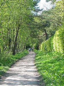
Deeside Way (Pathway)
The pathway is easily usable and shared by walkers, cyclists and horse riders alike, and runs from Duthie ParkDuthie Park
Duthie park, situated in Aberdeen, Scotland, by the banks of the River Dee, comprises of land gifted to the council in 1881 by Lady Elizabeth Duthie of Ruthrieston, in memory of her uncle and of her brother...
, Aberdeen to Peterculter
Peterculter
Peterculter , also known as Culter, is a suburb of Aberdeen, Scotland approximately eight miles inland from Aberdeen city centre. Peterculter is situated along the northern banks of the River Dee in the vicinity of the confluences with Crynoch Burn and Leuchar Burn...
with two breaks across quiet country roads and a larger one at the busy Milltimber Brae. It then breaks again for around a mile along Coalford Croft (there is some signposting to help guide), until it picks up and there is a narrow path to Drumoak. You then travel up to the North Deeside Road where it picks up further along and it opens out into a wide path until it reaches Crathes,where you must go around and back onto the A957 and there is a small road onto the path once more. This leads on into Banchory
Banchory
Banchory is a burgh or town in Aberdeenshire, Scotland, lying approximately 18 miles west of Aberdeen, near where the Feugh River meets the River Dee.- Overview :...
alongside the Deeside Railway, arriving in Bellfield Park.
There is currently no route between Banchory
Banchory
Banchory is a burgh or town in Aberdeenshire, Scotland, lying approximately 18 miles west of Aberdeen, near where the Feugh River meets the River Dee.- Overview :...
and Potarch
Potarch
Potarch is a hamlet in Aberdeenshire, Scotland, with a bridge across the River Dee.It is a popular location with tourists and day trippers, and has a hotel.-References:...
, although work was carried out in 2010 to repair footpaths around Scolty Hill which will form part of the proposed route.
From Potarch
Potarch
Potarch is a hamlet in Aberdeenshire, Scotland, with a bridge across the River Dee.It is a popular location with tourists and day trippers, and has a hotel.-References:...
, in 2010 the latest section of the path was completed, which runs over a newly built bridge before heading alongside the River Dee, and into Kincardine O'Neil
Kincardine O'Neil
Kincardine O'Neil is one of the oldest villages in Deeside, in the northeast of Scotland. It is situated between Banchory and Aboyne. The village is known locally as Kinker, and was formerly known as Eaglais Iarach in Gaelic....
.
Between Kincardine O'Neil
Kincardine O'Neil
Kincardine O'Neil is one of the oldest villages in Deeside, in the northeast of Scotland. It is situated between Banchory and Aboyne. The village is known locally as Kinker, and was formerly known as Eaglais Iarach in Gaelic....
and Aboyne
Aboyne
Aboyne is a village on the edge of the Highlands in Aberdeenshire, Scotland, on the River Dee, approximately west of Aberdeen. It has a rugby club, which plays on The Green and also has a swimming pool, a golf course with 18 holes, all-weather tennis courts, and a bowling green...
there is again no route currently available. From Aboyne
Aboyne
Aboyne is a village on the edge of the Highlands in Aberdeenshire, Scotland, on the River Dee, approximately west of Aberdeen. It has a rugby club, which plays on The Green and also has a swimming pool, a golf course with 18 holes, all-weather tennis courts, and a bowling green...
the route is now completed through to Ballater
Ballater
Ballater is a burgh in Aberdeenshire, Scotland on the River Dee, immediately east of the Cairngorm Mountains. Situated at a height of 123m in elevation, Ballater is a centre for hikers and known for its spring water, once said to cure scrofula.-History:The medieval pattern of development along...
.
A bridge across Holburn Street in Aberdeen was built in 2005, and in March 2010 another bridge was opened over West Cults Road. There are plans to eventually improve the line so that all breaks will be bridged providing a safe unbroken path from the Duthie Park
Duthie Park
Duthie park, situated in Aberdeen, Scotland, by the banks of the River Dee, comprises of land gifted to the council in 1881 by Lady Elizabeth Duthie of Ruthrieston, in memory of her uncle and of her brother...
to Banchory
Banchory
Banchory is a burgh or town in Aberdeenshire, Scotland, lying approximately 18 miles west of Aberdeen, near where the Feugh River meets the River Dee.- Overview :...
. The route is to connect up to Ballater
Ballater
Ballater is a burgh in Aberdeenshire, Scotland on the River Dee, immediately east of the Cairngorm Mountains. Situated at a height of 123m in elevation, Ballater is a centre for hikers and known for its spring water, once said to cure scrofula.-History:The medieval pattern of development along...
via Kincardine O'Neil
Kincardine O'Neil
Kincardine O'Neil is one of the oldest villages in Deeside, in the northeast of Scotland. It is situated between Banchory and Aboyne. The village is known locally as Kinker, and was formerly known as Eaglais Iarach in Gaelic....
, instead of following the original line through Lumphanan
Lumphanan
Lumphanan is a village in Aberdeenshire, Scotland located 25 miles from Aberdeen and 10 miles from Banchory. There is one pub in the village called "The MacBeth Arms", there is another bar located three miles from the village centre named "The Crossroads Hotel"...
. Only the route between Banchory
Banchory
Banchory is a burgh or town in Aberdeenshire, Scotland, lying approximately 18 miles west of Aberdeen, near where the Feugh River meets the River Dee.- Overview :...
and Potarch
Potarch
Potarch is a hamlet in Aberdeenshire, Scotland, with a bridge across the River Dee.It is a popular location with tourists and day trippers, and has a hotel.-References:...
, and Kincardine O'Neil
Kincardine O'Neil
Kincardine O'Neil is one of the oldest villages in Deeside, in the northeast of Scotland. It is situated between Banchory and Aboyne. The village is known locally as Kinker, and was formerly known as Eaglais Iarach in Gaelic....
and Aboyne
Aboyne
Aboyne is a village on the edge of the Highlands in Aberdeenshire, Scotland, on the River Dee, approximately west of Aberdeen. It has a rugby club, which plays on The Green and also has a swimming pool, a golf course with 18 holes, all-weather tennis courts, and a bowling green...
remain to be completed in order for the path to run completely from Aberdeen
Aberdeen
Aberdeen is Scotland's third most populous city, one of Scotland's 32 local government council areas and the United Kingdom's 25th most populous city, with an official population estimate of ....
to Ballater
Ballater
Ballater is a burgh in Aberdeenshire, Scotland on the River Dee, immediately east of the Cairngorm Mountains. Situated at a height of 123m in elevation, Ballater is a centre for hikers and known for its spring water, once said to cure scrofula.-History:The medieval pattern of development along...
.
Laying of tarmac along sections of the path within built up areas of Aberdeen has taken place to improve from the current path which floods leading to thick mud patches during the autumn and winter months.
The track is now part of the National Cycle Network
National Cycle Network
The National Cycle Network is a network of cycle routes in the United Kingdom.The National Cycle Network was created by the charity Sustrans , and aided by a £42.5 million National Lottery grant. In 2005 it was used for over 230 million trips.Many routes hope to minimise contact with motor...
, as National Route 195. Once completed, the track may also be added to the list of Long Distance Routes
Long Distance Routes
Long Distance Route is an official term for maintained long-distance footpaths in Scotland that require several days to walk...
.