
Kiwai Island
Encyclopedia
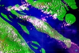
Kiwai Island is the largest island in the Fly River
delta, Papua New Guinea
. It is 59 km long along the northwest-southeast axis from Wamimuba Point in the northwest to the village of Saguane (Sanguane) in the south, and up to 9 km wide, with an average width of 5.6 km. Its area is 359 km² . Neighboring Purutu
and Wabuda Island
s to the north and northeast are also among the three largest islands in the Fly River delta. The island has a population of about 4500..
The island separates the north and south entrances of the Fly River. It is well wooded and only a few feet above water. The chief village, Iasa, is located on the south side of the island. Sumai village is on the same side of the island and 24 km farther northwest. Doropo village is about midway along the north side of the island. At the east end of the island are other small villages, such as Sagasia, Ipisia, Agobara and Oromosapuo.
The inhabitants of the Fly River delta engage in agriculture and hunting. Coconut palm, breadfruit, plantain, sago palm, and sugar cane are grown.
Administratively, the island is are part of Gogodala Rural LLG (Local Level Government area) of Middle Fly District, Western Province
.
Fly River
The Fly at , is the second longest river, after the Sepik, in Papua New Guinea. The Fly is the largest river in Oceania, the largest in the world without a single dam in its catchment, and overall ranks as the twenty-fifth largest river in the world by volume of discharge...
delta, Papua New Guinea
Papua New Guinea
Papua New Guinea , officially the Independent State of Papua New Guinea, is a country in Oceania, occupying the eastern half of the island of New Guinea and numerous offshore islands...
. It is 59 km long along the northwest-southeast axis from Wamimuba Point in the northwest to the village of Saguane (Sanguane) in the south, and up to 9 km wide, with an average width of 5.6 km. Its area is 359 km² . Neighboring Purutu
Purutu Island
Purutu Island Is an island in the Fly River delta, Papua New Guinea. Its area is 186 km2....
and Wabuda Island
Wabuda Island
Wabuda Island is an island in the Fly River delta, Papua New Guinea. Its area is 109 km²....
s to the north and northeast are also among the three largest islands in the Fly River delta. The island has a population of about 4500..
The island separates the north and south entrances of the Fly River. It is well wooded and only a few feet above water. The chief village, Iasa, is located on the south side of the island. Sumai village is on the same side of the island and 24 km farther northwest. Doropo village is about midway along the north side of the island. At the east end of the island are other small villages, such as Sagasia, Ipisia, Agobara and Oromosapuo.
The inhabitants of the Fly River delta engage in agriculture and hunting. Coconut palm, breadfruit, plantain, sago palm, and sugar cane are grown.
Administratively, the island is are part of Gogodala Rural LLG (Local Level Government area) of Middle Fly District, Western Province
Middle Fly District, Western Province
The Middle Fly District of the Western Province of Papua New Guinea is a large, coastal district that forms the central area of the Fly River basin. It contains the Local-Level Government areas of: Balimo Urban, Bamu Rural, Gogodaia Rural, Lake Murray Rural, and Nomad Rural, and the population...
.