

Esclusham
Encyclopedia
Esclusham is a local government community
, the lowest tier of local government, part of Wrexham County Borough in Wales
.
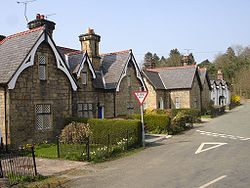
The community includes the villages of Bersham
, Rhostyllen
, Aber-oer, Llwyneinion and Pentre Bychan
, as well as a number of smaller settlements, the park at Erddig
, and an area of the Ruabon Moors
west of Aber-oer known as Esclusham Mountain
.
 The name is recorded as Esclesham or Esclusham as early as 1315, likely originating in a combination of the Old English personal name Æscel with ham, "settlement"; the name is locally pronounced with stress on the second (middle) syllable, probably due to the influence of Welsh language
stress patterns.
The old township
of Esclusham, within the manor
of Esclusham, was part of the historic Marcher Lordship
of Bromfield and Yale. The Survey of topographer John Norden
, carried out in 1620 within Bromfield and Yale, defined the township as follows:
The jurors noted that "vpon ye mountaynes and commons in and about this manno' do breed moore cockes
and growes, w'ch gentlemen of ye countrey of Chesshire
and other places do hawke and take them at some seasons of the yeare".
The township of Esclusham Above (i.e "above" Offa's Dyke
) was incorporated in the parish of Minera from 1844; in 1879 parts of Esclusham Above, Esclusham Below, and Erddig were incorporated in the civil parish
of Esclusham. As a result of the Local Government Act 1972
, this was itself replaced in 1974 by the Community of Esclusham, currently based in the Parish Hall, Rhostyllen.
. In the western, rural part of the community the land rises to the high pastureland and moorland above Fron-deg and Aber-oer known as Esclusham Mountain.
Until the early 20th century there were lead and zinc mines on the mountain, and the area was used for grouse shooting. There are several structures of interest in industrial archeology, including the Bersham Ironworks
and old lead workings. The Minera Caves, a Site of Special Scientific Interest
, lie beneath Esclusham Mountain: over 8 kilometres of caves connecting with the old lead workings have now been mapped.
Community (Wales)
A community is a division of land in Wales that forms the lowest-tier of local government in Wales. Welsh communities are analogous to civil parishes in England....
, the lowest tier of local government, part of Wrexham County Borough in Wales
Wales
Wales is a country that is part of the United Kingdom and the island of Great Britain, bordered by England to its east and the Atlantic Ocean and Irish Sea to its west. It has a population of three million, and a total area of 20,779 km²...
.
The community includes the villages of Bersham
Bersham
Bersham is a small Welsh village in the suburbs of the county borough of Wrexham that lies next to the River Clywedog. Wrexham owes a large amount of its original industrial heritage to Bersham, but despite this the village still retains a rural feeling....
, Rhostyllen
Rhostyllen
Rhostyllen is a village in Wrexham county borough in Wales, south-west of the town of Wrexham. At the time of the 2001 census, area Wrexham 014A, which includes Rhostyllen itself, had a population of 1,383 in 599 households...
, Aber-oer, Llwyneinion and Pentre Bychan
Pentre Bychan
Pentrebychan is a village in the county borough of Wrexham, Wales....
, as well as a number of smaller settlements, the park at Erddig
Erddig
Erddig Hall is a National Trust property on the outskirts of Wrexham, Wales. Located south of Wrexham town centre, it was built in 1684–1687 for Joshua Edisbury, the high sheriff of Denbighshire and was designed by Thomas Webb....
, and an area of the Ruabon Moors
Ruabon Moors
Ruabon Moors are an area of upland moorland in Wales to the west of Ruabon and Wrexham. They lie partly within Wrexham county borough and partly within Denbighshire....
west of Aber-oer known as Esclusham Mountain
Esclusham Mountain
Esclusham Mountain is an area in the north-east of Wales and is part of the Ruabon Moors. It rises to a height of 460 m , with the nearby spur of Cyrn-y-Brain, to the west, reaching 473 m . It lies mostly within the community of Esclusham...
.
History
Welsh language
Welsh is a member of the Brythonic branch of the Celtic languages spoken natively in Wales, by some along the Welsh border in England, and in Y Wladfa...
stress patterns.
The old township
Township (England)
In England, a township is a local division or district of a large parish containing a village or small town usually having its own church...
of Esclusham, within the manor
Manorialism
Manorialism, an essential element of feudal society, was the organizing principle of rural economy that originated in the villa system of the Late Roman Empire, was widely practiced in medieval western and parts of central Europe, and was slowly replaced by the advent of a money-based market...
of Esclusham, was part of the historic Marcher Lordship
Welsh Marches
The Welsh Marches is a term which, in modern usage, denotes an imprecisely defined area along and around the border between England and Wales in the United Kingdom. The precise meaning of the term has varied at different periods...
of Bromfield and Yale. The Survey of topographer John Norden
John Norden
John Norden was an English cartographer, chorographer and antiquary. He planned a series of county maps and accompanying county histories of England, the Speculum Britanniae...
, carried out in 1620 within Bromfield and Yale, defined the township as follows:
[...] the towneshipp of Esclusham, beeing part of ye said manno', is bounden from MineraMineraMinera is a small village, and a local government community, the lowest tier of local government, part of Wrexham County Borough in Wales.The community, which in addition to Minera village includes a number of smaller hamlets such as Gwynfryn and New Brighton and large areas of farmland, had a...
by a little purle of water running from the mountayne called Glas-bry, downe by the landes called Tir Kelin, and so to ClywedogClywedogClywedog may refer to:* River Clywedog, a tributary of River Dee near Wrexham* A tributary of the River Mawddach* Clywedog Reservoir, a reservoir in the Welsh county of Powys* River Clywedog, Denbigh, a tributary of the River Clwyd...
vpon ye west by the landes of Hugh ap Robert ap Howell in ye manno' of Minera, and part of Glasbrie, and part of ye mountayne towardes y Groes Newydd ; but the certaine boundes vpon ye said mountayne they cannot sett downe. And from Mortyn Wallicoru' by a brooke called Holbrooke, through certaine
feildes with certaine markes knowne, to a place called Aberderryn, and from thence to a place called Penissa Maeswdd Kynelleth to a brooke called yr Avon Ddu ; and from Morton Anglicoru' the said Avon Ddu doth bounde to ye towneshipp of Erddig, and from thence to Clywedoge, ioyning to ye towneshippe of Bersham in ye said manno'.
The jurors noted that "vpon ye mountaynes and commons in and about this manno' do breed moore cockes
Red grouse
The Red Grouse is a medium sized bird of the grouse family which is found in heather moorland in Great Britain and Ireland. It is usually classified as a subspecies of the Willow Grouse but is sometimes considered to be a separate species Lagopus scoticus...
and growes, w'ch gentlemen of ye countrey of Chesshire
Cheshire
Cheshire is a ceremonial county in North West England. Cheshire's county town is the city of Chester, although its largest town is Warrington. Other major towns include Widnes, Congleton, Crewe, Ellesmere Port, Runcorn, Macclesfield, Winsford, Northwich, and Wilmslow...
and other places do hawke and take them at some seasons of the yeare".
The township of Esclusham Above (i.e "above" Offa's Dyke
Offa's Dyke
Offa's Dyke is a massive linear earthwork, roughly followed by some of the current border between England and Wales. In places, it is up to wide and high. In the 8th century it formed some kind of delineation between the Anglian kingdom of Mercia and the Welsh kingdom of Powys...
) was incorporated in the parish of Minera from 1844; in 1879 parts of Esclusham Above, Esclusham Below, and Erddig were incorporated in the civil parish
Civil parish
In England, a civil parish is a territorial designation and, where they are found, the lowest tier of local government below districts and counties...
of Esclusham. As a result of the Local Government Act 1972
Local Government Act 1972
The Local Government Act 1972 is an Act of Parliament in the United Kingdom that reformed local government in England and Wales on 1 April 1974....
, this was itself replaced in 1974 by the Community of Esclusham, currently based in the Parish Hall, Rhostyllen.
Features
The community has a total area of 1656 hectares and had 3401 inhabitants at the 2001 census. Its eastern part is relatively urbanised, with the village of Rhostyllen being close to the suburbs of WrexhamWrexham
Wrexham is a town in Wales. It is the administrative centre of the wider Wrexham County Borough, and the largest town in North Wales, located in the east of the region. It is situated between the Welsh mountains and the lower Dee Valley close to the border with Cheshire, England...
. In the western, rural part of the community the land rises to the high pastureland and moorland above Fron-deg and Aber-oer known as Esclusham Mountain.
Until the early 20th century there were lead and zinc mines on the mountain, and the area was used for grouse shooting. There are several structures of interest in industrial archeology, including the Bersham Ironworks
Bersham Ironworks
Bersham Ironworks were large ironworks at Bersham, near Wrexham, North Wales. They are most famous for being the original working site of John Wilkinson...
and old lead workings. The Minera Caves, a Site of Special Scientific Interest
Site of Special Scientific Interest
A Site of Special Scientific Interest is a conservation designation denoting a protected area in the United Kingdom. SSSIs are the basic building block of site-based nature conservation legislation and most other legal nature/geological conservation designations in Great Britain are based upon...
, lie beneath Esclusham Mountain: over 8 kilometres of caves connecting with the old lead workings have now been mapped.