
Cezarina
Encyclopedia
| Cezarina | |
|---|---|
| State | Goiás Goiás Goiás is a state of Brazil, located in the central part of the country. The name Goiás comes from the name of an indigenous community... |
| Area: | 417.2 km² |
| Population: | 7,361 (IBGE 2007) |
| Elevation: | 596m above sea level |
| Postcode (CEP): | 76195-000 |
| IBGE statistical microregion: | Vale do Rio dos Bois |
| Became a city: | 1989 |
| Distance to Goiânia Goiânia -Climate:The city has a tropical wet and dry climate with an average temperature of . There's a wet season, from October to April, and a dry one, from May to September. Annual rainfall is around 1,520 mm.... : |
73 km. |
| Website: | Câmara Municipal de Cezarina |
Municipality
A municipality is essentially an urban administrative division having corporate status and usually powers of self-government. It can also be used to mean the governing body of a municipality. A municipality is a general-purpose administrative subdivision, as opposed to a special-purpose district...
in central Goiás
Goiás
Goiás is a state of Brazil, located in the central part of the country. The name Goiás comes from the name of an indigenous community...
state, Brazil
Brazil
Brazil , officially the Federative Republic of Brazil , is the largest country in South America. It is the world's fifth largest country, both by geographical area and by population with over 192 million people...
.
Location and Communications
Cezarina belongs to the Vale do Rio dos Bois statistical micro-region. It has municipal boundaries with:- north: Palmeiras de GoiásPalmeiras de GoiásPalmeiras de Goiás is a small city and municipality in southestern Goiás state, Brazil.-Location:Palmeiras de Goiás is located in the statistical micro-region of Vale do Rio dos Bois at a distance of 88 kilometers from the state capital, Goiânia. It is 26 kilometers from Cezarina and the important...
- south: EdealinaEdealinaEdealina is a small town and municipality in central-south Goiás state, Brazil.-Location:Edealina has municipal boundaries with Edéia, Pontalina, Indiara, and Cezarina The important Rio dos Bois forms part of the municipal boundary....
- east: VarjãoVarjãoVarjão is a small town and municipality in western Goiás state, Brazil.Geography and DemographicsVarjão is located 77 km. southwest of Goiânia and is 26 km. southeast of Cezarina. Highway connections from Goiânia are made by BR-060/Abadia de Goiás/Guapó/GO-413. Aragoiânia, Cezarina, Indiara,...
- west: IndiaraIndiaraIndiara is a small city and municipality in central-south Goiás state, Brazil. Indiara is a large producer of soybeans and cotton.-Location:Indiara is located in the Vale do Rio dos Bois and has municipal boundaries with:*north: Palmeiras de Goiás...
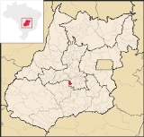
Cezarina is located 73 kilometers southwest of the state capital, Goiânia
Goiânia
-Climate:The city has a tropical wet and dry climate with an average temperature of . There's a wet season, from October to April, and a dry one, from May to September. Annual rainfall is around 1,520 mm....
. It is on the BR-060 highway, which connects Brasília
Brasília
Brasília is the capital city of Brazil. The name is commonly spelled Brasilia in English. The city and its District are located in the Central-West region of the country, along a plateau known as Planalto Central. It has a population of about 2,557,000 as of the 2008 IBGE estimate, making it the...
to Jataí
Jataí
Jataí is a municipality in southern Goiás state, Brazil. Its population was 88,048 in a total area of 7,174.2 km². Jataí is a major producer of agricultural products, including soybeans, rice, and corn. It has the largest herd of cattle in the state and is a large producer of poultry and...
in southwestern Goiás
Goiás
Goiás is a state of Brazil, located in the central part of the country. The name Goiás comes from the name of an indigenous community...
.
Important rivers are the Rio dos Bois, which flows north-south to join the Paranaíba
Paranaíba River
The Paranaíba River is a Brazilian river whose source lies in the state of Minas Gerais in the Mata da Corda mountains, municipality of Rio Paranaíba, at an altitude of 1,148 meters; on the other face of this mountain chain are the sources of the Abaeté river, tributary of the São Francisco River...
.
Demographic and Political Data
- Population density in 2007: 17.704 inhab/km²
- Population growth rate 2000/2007: 1.761.%
- Urban population in 2007: 5,127
- Rural population in 2007: 2,234
- Eligible voters in 2007: 6,724
- City government in 2005: Mayor (Prefeito)--Adinilso Sirico, Vice-mayor (Vice-Prefeito)--Artur Franco de Almeida Filho, City council (Vereadores): 09
Economy
The economy was based on cattle raising, agriculture, small transformation industries, meat packing, and dairies. There were 38,000 head of cattle in 2006.- Industrial units: 22 (2007)
- Retail units: 78 (2007)
- Financial institutions: Banco Itaú S.A (2007)
- Packing house: Persa Indústria e Comércio de Carnes e Derivados Ltda
- Dairy: Laticínios Almeida Reis Ltda (2007)
- Automobiles: 760
- Pickup trucks: 78
- Motorcycles: 404
Agricultural Data
- Number of farms: 379
- Total area: 33,395
- Planted area: 2,150 ha.
- Area of natural pasture: 25,655
- Workers in agriculture: 1,010
Health and education
- Infant mortality rate: 25.29 in 1,000 live births (2000)
- Hospitals: 01 with 28 beds (2007)
- Public health clinics (SUS): 05 (2003)
- Literacy rate: 79.1% in 2000
- Schools: 06 with 2,171 students (2006)
- Higher education: none in June 2005
History
Cezarina began in 1960, with the construction of the BR-060 highway. At that time the rancher, João Argemiro Cezar decided to donate his lands, where the center of the town is presently located. He hired Agil José da Rocha to measure the lands, granting him a free lot. Agil José built a gasoline station on the edge of the highway, which became the first building in Cezarina. Little by little the town began to grow. The name "Cezarina" was chosen because of its founder, João Cezar. In 1988 it became a city.Ranking on the Municipal Human Development Index
Human Development Index
The Human Development Index is a composite statistic used to rank countries by level of "human development" and separate "very high human development", "high human development", "medium human development", and "low human development" countries...
- MHDI: 0.747
- State ranking: 85 (out of 242 municipalities in 2000)
- National ranking: 1,976 (out of 5,507 municipalities in 2000)
See also
- List of municipalities in Goiás
- Microregions of Goiás