

Eau Claire County, Wisconsin
Encyclopedia
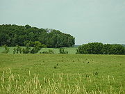
Eau Claire County is a county
located in the U.S. state
of Wisconsin
. As of 2010, the population estimate was 98,736. Its county seat
is Eau Claire
.
The United States Census Bureau
's Eau Claire Metropolitan Statistical Area includes all of Eau Claire County (as well as Chippewa County
to the north). Together with the Menomonie Micropolitan Statistical Area (which includes all of Dunn County) to the west, the Eau Claire metropolitan area, forms the Census Bureau's Eau Claire-Menomonie Combined Statistical Area
, which had a consolidated 2010 population of 205,008.
, Dells Mill Museum in Augusta
, Dells Mill Water Powered Museum in Augusta
, the Paul Bunyan Logging Camp in Eau Claire
, and the Sarge Boyd Bandshell
in Eau Claire
.
, in 1855. The name was changed to the Town of Eau Claire on March 31, 1856. The entire town was separated as Eau Claire County by an act of the Wisconsin State Legislature on October 6, 1856.
, the county has a total area of 645 square miles (1,670.5 km²), of which 638 square miles (1,652.4 km²) is land and 8 square miles (20.7 km²) (1.18%) is water.
. The board consists of 29 supervisors, including the chair and vice-chair. The main political parties are the Democratic Party of Eau Claire County
and the Republican Party of Eau Claire County
Eau Claire County contains portions of the Wisconsin State Senate
districts 23 and 31, represented by Terry Moulton
(R) and Kathleen Vinehout
(D) respectively. It also contains portions of Wisconsin State Assembly
districts 68 (Kathy Bernier
[R]), 69 (Scott Suder
[R]), 92 (Mark Radcliffe
[D]), and 93 (Warren Petryk
[R]). At the federal level, the entire county is contained within Wisconsin's third congressional district, which is represented in the United States House of Representatives
by Ron Kind
(D).
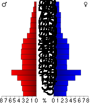
As of the census
of 2000, there were 93,142 people, 35,822 households, and 22,281 families residing in the county. The population density
was 146 people per square mile (56/km²). There are 37,474 housing
units at an average density of 59 per square mile (23/km²). The racial makeup of the county was 94.96% White
, 0.52% Black
or African American
, 0.54% Native American
, 2.52% Asian
, 0.03% Pacific Islander
, 0.33% from other races
, and 1.11% from two or more races. 0.94% of the population were Hispanic
or Latino
of any race. 37.4% were of German, 21.5% Norwegian and 7.0% Irish
ancestry according to Census 2000. 94.2% spoke English
, 1.6% Hmong
, 1.6% Spanish
and 1.0% German
as their first language.
There were 35,822 households out of which 30.00% had children under the age of 18 living with them, 50.60% were married couples
living together, 8.60% had a female householder with no husband present, and 37.80% were non-families. 27.10% of all households were made up of individuals and 10.10% had someone living alone who was 65 years of age or older. The average household size was 2.46 and the average family size was 3.02.
In the county, the population was spread out with 23.40% under the age of 18, 17.10% from 18 to 24, 26.70% from 25 to 44, 20.50% from 45 to 64, and 12.20% who were 65 years of age or older. The median age was 32 years. For every 100 females there were 93.80 males. For every 100 females age 18 and over, there were 90.60 males.
 Cities
Villages
Towns
* indicates a municipality considered part of the Eau Claire-Chippewa Falls metropolitan area
.
‡ Historical community
§ Now part of the City of Eau Claire
County (United States)
In the United States, a county is a geographic subdivision of a state , usually assigned some governmental authority. The term "county" is used in 48 of the 50 states; Louisiana is divided into parishes and Alaska into boroughs. Parishes and boroughs are called "county-equivalents" by the U.S...
located in the U.S. state
U.S. state
A U.S. state is any one of the 50 federated states of the United States of America that share sovereignty with the federal government. Because of this shared sovereignty, an American is a citizen both of the federal entity and of his or her state of domicile. Four states use the official title of...
of Wisconsin
Wisconsin
Wisconsin is a U.S. state located in the north-central United States and is part of the Midwest. It is bordered by Minnesota to the west, Iowa to the southwest, Illinois to the south, Lake Michigan to the east, Michigan to the northeast, and Lake Superior to the north. Wisconsin's capital is...
. As of 2010, the population estimate was 98,736. Its county seat
County seat
A county seat is an administrative center, or seat of government, for a county or civil parish. The term is primarily used in the United States....
is Eau Claire
Eau Claire, Wisconsin
Eau Claire is a city located in the west-central part of the U.S. state of Wisconsin. The population was 65,883 as of the 2010 census, making it the largest municipality in the northwestern portion of the state, and the 9th largest in the state overall. It is the county seat of Eau Claire County,...
.
The United States Census Bureau
United States Census Bureau
The United States Census Bureau is the government agency that is responsible for the United States Census. It also gathers other national demographic and economic data...
's Eau Claire Metropolitan Statistical Area includes all of Eau Claire County (as well as Chippewa County
Chippewa County, Wisconsin
Chippewa County is a county located in the U.S. state of Wisconsin. As of 2000, the population was 55,195. Its county seat is Chippewa Falls. The United States Census Bureau's Eau Claire Metropolitan Statistical Area includes all of Chippewa County...
to the north). Together with the Menomonie Micropolitan Statistical Area (which includes all of Dunn County) to the west, the Eau Claire metropolitan area, forms the Census Bureau's Eau Claire-Menomonie Combined Statistical Area
Combined Statistical Area
The United States Office of Management and Budget defines micropolitan and metropolitan statistical areas. Metropolitan and micropolitan statistical areas consist of one or more counties...
, which had a consolidated 2010 population of 205,008.
Attractions
Attractions include the Chippewa Valley Museum in Eau ClaireEau Claire, Wisconsin
Eau Claire is a city located in the west-central part of the U.S. state of Wisconsin. The population was 65,883 as of the 2010 census, making it the largest municipality in the northwestern portion of the state, and the 9th largest in the state overall. It is the county seat of Eau Claire County,...
, Dells Mill Museum in Augusta
Augusta, Wisconsin
Augusta is a city in Eau Claire County, Wisconsin, United States. The population was 1,550 at the 2010 census. The city is located entirely within the Town of Bridge Creek.-Geography:Augusta is located at ....
, Dells Mill Water Powered Museum in Augusta
Augusta, Wisconsin
Augusta is a city in Eau Claire County, Wisconsin, United States. The population was 1,550 at the 2010 census. The city is located entirely within the Town of Bridge Creek.-Geography:Augusta is located at ....
, the Paul Bunyan Logging Camp in Eau Claire
Eau Claire, Wisconsin
Eau Claire is a city located in the west-central part of the U.S. state of Wisconsin. The population was 65,883 as of the 2010 census, making it the largest municipality in the northwestern portion of the state, and the 9th largest in the state overall. It is the county seat of Eau Claire County,...
, and the Sarge Boyd Bandshell
Sarge Boyd Bandshell
The Sarge Boyd Bandshell of Eau Claire, Wisconsin, as home to the city's oldest community musical organization, has played a significant role in the cultural development of the entire Chippewa Valley. The structure was designed by city engineer Alex Garnock for the purpose of showcasing the Eau...
in Eau Claire
Eau Claire, Wisconsin
Eau Claire is a city located in the west-central part of the U.S. state of Wisconsin. The population was 65,883 as of the 2010 census, making it the largest municipality in the northwestern portion of the state, and the 9th largest in the state overall. It is the county seat of Eau Claire County,...
.
History
Eau Claire county was originally set off as the Town of Clearwater in Chippewa CountyChippewa County, Wisconsin
Chippewa County is a county located in the U.S. state of Wisconsin. As of 2000, the population was 55,195. Its county seat is Chippewa Falls. The United States Census Bureau's Eau Claire Metropolitan Statistical Area includes all of Chippewa County...
, in 1855. The name was changed to the Town of Eau Claire on March 31, 1856. The entire town was separated as Eau Claire County by an act of the Wisconsin State Legislature on October 6, 1856.
Geography
According to the U.S. Census BureauUnited States Census Bureau
The United States Census Bureau is the government agency that is responsible for the United States Census. It also gathers other national demographic and economic data...
, the county has a total area of 645 square miles (1,670.5 km²), of which 638 square miles (1,652.4 km²) is land and 8 square miles (20.7 km²) (1.18%) is water.
Government
The legislative body of Eau Claire County is the Eau Claire County Board of SupervisorsEau Claire County Board of Supervisors
The Eau Claire County Board of Supervisors is the non-partisan 29-member governing board of Eau Claire County, Wisconsin. Members of the board of supervisors are elected by district and the chairperson and vice-chair positions are elected from within members of the board.-Board meetings:The board...
. The board consists of 29 supervisors, including the chair and vice-chair. The main political parties are the Democratic Party of Eau Claire County
Democratic Party of Eau Claire County, Wisconsin
The Democratic Party of Eau Claire is the affiliate of the Democratic Party in Wisconsin. As of 2011, it is headed by Jeff Smith and Kristen Dexter, the co-Chairs. The party is currently the minority....
and the Republican Party of Eau Claire County
Republican Party of Eau Claire County, Wisconsin
The Republican Party of Eau Claire is the affiliate of the Republican Party in Wisconsin. As of 2009, it is headed by Brian Westrate, the Chair...
Eau Claire County contains portions of the Wisconsin State Senate
Wisconsin State Senate
The Wisconsin Senate, the powers of which are modeled after those of the U.S. Senate, is the upper house of the Wisconsin State Legislature, smaller than the Wisconsin State Assembly...
districts 23 and 31, represented by Terry Moulton
Terry Moulton
Terry Moulton is a Republican member of the Wisconsin Senate, representing the 23rd district since 2011. He was previously a member of the Wisconsin Assembly, representing the 68th district from 2005 to 2009....
(R) and Kathleen Vinehout
Kathleen Vinehout
Kathleen Vinehout, Ph.D, M.P.H. is a Democratic member of the Wisconsin Senate, representing the 31st district since 2007.- Early life, education and career :...
(D) respectively. It also contains portions of Wisconsin State Assembly
Wisconsin State Assembly
The Wisconsin State Assembly is the lower house of the Wisconsin Legislature. Together with the smaller Wisconsin Senate, the two constitute the legislative branch of the U.S. state of Wisconsin....
districts 68 (Kathy Bernier
Kathy Bernier
Kathleen M. "Kathy" Bernier is the State Representative for the 68th Wisconsin State Assembly district. She defeated incumbent Democrat Kristen Dexter in the November 2nd general election...
[R]), 69 (Scott Suder
Scott Suder
Scott Suder is an American politician from Abbotsford, Wisconsin. He is currently the Republican Majority Leader of the Wisconsin State Assembly, representing the 69th district since January 1998. He succeeded Robert K. Zukowski....
[R]), 92 (Mark Radcliffe
Mark Radcliffe
Mark Radcliffe is an English broadcaster who has worked in various roles for the BBC since the 1980s and remains one of Britain's most recognised DJs. He is currently a presenter on BBC Radio 2 and BBC 6 Music, where he hosts an afternoon show five times a week alongside Stuart Maconie, called...
[D]), and 93 (Warren Petryk
Warren Petryk
Warren Petryk is an American politician and a member of the Republican Party. He was elected to the Wisconsin State Assembly on November 2, 2010....
[R]). At the federal level, the entire county is contained within Wisconsin's third congressional district, which is represented in the United States House of Representatives
United States House of Representatives
The United States House of Representatives is one of the two Houses of the United States Congress, the bicameral legislature which also includes the Senate.The composition and powers of the House are established in Article One of the Constitution...
by Ron Kind
Ron Kind
Ronald James "Ron" Kind is the U.S. Representative for , serving since 1997. He is a member of the Democratic Party. His district is located in the western portion of the state and is anchored by La Crosse and Eau Claire and Platteville....
(D).
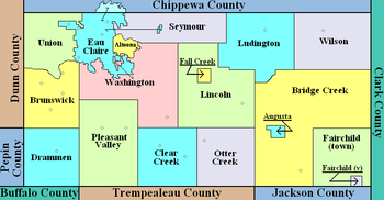
Adjacent counties
- Chippewa CountyChippewa County, WisconsinChippewa County is a county located in the U.S. state of Wisconsin. As of 2000, the population was 55,195. Its county seat is Chippewa Falls. The United States Census Bureau's Eau Claire Metropolitan Statistical Area includes all of Chippewa County...
- north - Clark County - east
- Jackson CountyJackson County, WisconsinJackson County is a county located in the U.S. state of Wisconsin. As of 2009, the population estimate was 19,886. Its county seat is Black River Falls. Jackson County was formed from Crawford County in 1853.-Geography:According to the U.S...
- southeast - Trempealeau CountyTrempealeau County, WisconsinTrempealeau County is a county located in the U.S. state of Wisconsin. As of 2009, the population estimate was 27,754. Its county seat is Whitehall.-History:Patches of woodland are all that remain of the brush and light forest that once covered the county...
- south - Buffalo CountyBuffalo County, WisconsinBuffalo County is a county located in the U.S. state of Wisconsin. As of 2000, the population was 13,804. Its county seat is Alma.-Geography:According to the U.S...
- southwest - Pepin County - west
- Dunn County - west
Major highways
|
 Highway 37 (Wisconsin) Highway 37 (Wisconsin)Highway 37 (Wisconsin) State Trunk Highway 37 is a state highway in the U.S. state of Wisconsin. It runs generally south-southwesterly through west-central Wisconsin from Eau Claire to Alma. The southern , from Mondovi to Alma, generally follows the course of the Buffalo River....  Highway 93 (Wisconsin) Highway 93 (Wisconsin)Highway 93 (Wisconsin) State Trunk Highway 93 is a state highway in the U.S. state of Wisconsin. It runs north–south in west-central Wisconsin from near Holmen to Eau Claire....  Highway 27 (Wisconsin) Highway 27 (Wisconsin)Highway 27 (Wisconsin) State Trunk Highway 27 is a state highway in the U.S. state of Wisconsin. The highway spans a length of and is generally two-lane local road with the exception of urban multilane arterials within some cities...  Highway 312 (Wisconsin) Highway 312 (Wisconsin)Highway 312 (Wisconsin) State Trunk Highway 312 is a long Wisconsin state highway running along the north side of Eau Claire, from the Town of Union in the west to the Town of Seymour in the east...  Highway 124 (Wisconsin) Highway 124 (Wisconsin)Highway 124 (Wisconsin) State Trunk Highway 124 is a state highway in the U.S. state of Wisconsin. It runs in north–south in west central Wisconsin from Lake Hallie to near Eagleton, in the Town of Eagle Point. The entire length of the highway is in Chippewa County... |

 U.S. Highway 12
 U.S. Highway 53
 U.S. Highway 10
Demographics
As of the census
Census
A census is the procedure of systematically acquiring and recording information about the members of a given population. It is a regularly occurring and official count of a particular population. The term is used mostly in connection with national population and housing censuses; other common...
of 2000, there were 93,142 people, 35,822 households, and 22,281 families residing in the county. The population density
Population density
Population density is a measurement of population per unit area or unit volume. It is frequently applied to living organisms, and particularly to humans...
was 146 people per square mile (56/km²). There are 37,474 housing
units at an average density of 59 per square mile (23/km²). The racial makeup of the county was 94.96% White
Race (United States Census)
Race and ethnicity in the United States Census, as defined by the Federal Office of Management and Budget and the United States Census Bureau, are self-identification data items in which residents choose the race or races with which they most closely identify, and indicate whether or not they are...
, 0.52% Black
Race (United States Census)
Race and ethnicity in the United States Census, as defined by the Federal Office of Management and Budget and the United States Census Bureau, are self-identification data items in which residents choose the race or races with which they most closely identify, and indicate whether or not they are...
or African American
Race (United States Census)
Race and ethnicity in the United States Census, as defined by the Federal Office of Management and Budget and the United States Census Bureau, are self-identification data items in which residents choose the race or races with which they most closely identify, and indicate whether or not they are...
, 0.54% Native American
Race (United States Census)
Race and ethnicity in the United States Census, as defined by the Federal Office of Management and Budget and the United States Census Bureau, are self-identification data items in which residents choose the race or races with which they most closely identify, and indicate whether or not they are...
, 2.52% Asian
Race (United States Census)
Race and ethnicity in the United States Census, as defined by the Federal Office of Management and Budget and the United States Census Bureau, are self-identification data items in which residents choose the race or races with which they most closely identify, and indicate whether or not they are...
, 0.03% Pacific Islander
Race (United States Census)
Race and ethnicity in the United States Census, as defined by the Federal Office of Management and Budget and the United States Census Bureau, are self-identification data items in which residents choose the race or races with which they most closely identify, and indicate whether or not they are...
, 0.33% from other races
Race (United States Census)
Race and ethnicity in the United States Census, as defined by the Federal Office of Management and Budget and the United States Census Bureau, are self-identification data items in which residents choose the race or races with which they most closely identify, and indicate whether or not they are...
, and 1.11% from two or more races. 0.94% of the population were Hispanic
Race (United States Census)
Race and ethnicity in the United States Census, as defined by the Federal Office of Management and Budget and the United States Census Bureau, are self-identification data items in which residents choose the race or races with which they most closely identify, and indicate whether or not they are...
or Latino
Race (United States Census)
Race and ethnicity in the United States Census, as defined by the Federal Office of Management and Budget and the United States Census Bureau, are self-identification data items in which residents choose the race or races with which they most closely identify, and indicate whether or not they are...
of any race. 37.4% were of German, 21.5% Norwegian and 7.0% Irish
Irish people
The Irish people are an ethnic group who originate in Ireland, an island in northwestern Europe. Ireland has been populated for around 9,000 years , with the Irish people's earliest ancestors recorded having legends of being descended from groups such as the Nemedians, Fomorians, Fir Bolg, Tuatha...
ancestry according to Census 2000. 94.2% spoke English
English language
English is a West Germanic language that arose in the Anglo-Saxon kingdoms of England and spread into what was to become south-east Scotland under the influence of the Anglian medieval kingdom of Northumbria...
, 1.6% Hmong
Hmong language
Hmong or Mong is the common name for a dialect continuum of the West Hmongic branch of the Hmong–Mien/Miao–Yao language family spoken by the Hmong people of Sichuan, Yunnan, Guizhou, Guangxi, northern Vietnam, Thailand, and Laos...
, 1.6% Spanish
Spanish language
Spanish , also known as Castilian , is a Romance language in the Ibero-Romance group that evolved from several languages and dialects in central-northern Iberia around the 9th century and gradually spread with the expansion of the Kingdom of Castile into central and southern Iberia during the...
and 1.0% German
German language
German is a West Germanic language, related to and classified alongside English and Dutch. With an estimated 90 – 98 million native speakers, German is one of the world's major languages and is the most widely-spoken first language in the European Union....
as their first language.
There were 35,822 households out of which 30.00% had children under the age of 18 living with them, 50.60% were married couples
Marriage
Marriage is a social union or legal contract between people that creates kinship. It is an institution in which interpersonal relationships, usually intimate and sexual, are acknowledged in a variety of ways, depending on the culture or subculture in which it is found...
living together, 8.60% had a female householder with no husband present, and 37.80% were non-families. 27.10% of all households were made up of individuals and 10.10% had someone living alone who was 65 years of age or older. The average household size was 2.46 and the average family size was 3.02.
In the county, the population was spread out with 23.40% under the age of 18, 17.10% from 18 to 24, 26.70% from 25 to 44, 20.50% from 45 to 64, and 12.20% who were 65 years of age or older. The median age was 32 years. For every 100 females there were 93.80 males. For every 100 females age 18 and over, there were 90.60 males.
Cities, villages, and towns
- AltoonaAltoona, WisconsinAltoona is a city in Eau Claire County, Wisconsin, United States. The population was 6,706 at the 2010 census. The city is a railroad terminal on the Union Pacific Railroad.-History:...
* - AugustaAugusta, WisconsinAugusta is a city in Eau Claire County, Wisconsin, United States. The population was 1,550 at the 2010 census. The city is located entirely within the Town of Bridge Creek.-Geography:Augusta is located at ....
- Eau ClaireEau Claire, WisconsinEau Claire is a city located in the west-central part of the U.S. state of Wisconsin. The population was 65,883 as of the 2010 census, making it the largest municipality in the northwestern portion of the state, and the 9th largest in the state overall. It is the county seat of Eau Claire County,...
* (part)
Villages
- FairchildFairchild, WisconsinFairchild is a village in Eau Claire County, Wisconsin, United States. The population was 564 at the 2000 census. The village is located within the Town of Fairchild.-Geography:Fairchild is located at ....
- Fall CreekFall Creek, WisconsinFall Creek is a village in Eau Claire County, Wisconsin, United States. The population was 1,236 at the 2000 census. The village is located within and entirely surrounded by the Town of Lincoln.-Geography:Fall Creek is located at ....
Towns
- Bridge CreekBridge Creek, WisconsinBridge Creek is a town in Eau Claire County, Wisconsin, United States. The population was 1,900 at the 2010 census. The city of Augusta is located entirely within the town of Bridge Creek...
- Brunswick*
- Clear CreekClear Creek, WisconsinAs of the census of 2000, there were 712 people, 268 households, and 216 families residing in the town. The population density was 19.8 people per square mile . There were 278 housing units at an average density of 7.7 per square mile . The racial makeup of the town was 99.16% White, 0.42% from...
- DrammenDrammen, WisconsinDrammen is a town in Eau Claire County, Wisconsin, United States. The population was 800 at the 2000 census.-Geography:According to the United States Census Bureau, the town has a total area of 35.9 square miles , all of it land...
- FairchildFairchild (town), WisconsinFairchild is a town in Eau Claire County, Wisconsin, United States. The population was 351 at the 2000 census. The Village of Fairchild is located within the town.-Geography:...
- LincolnLincoln, Eau Claire County, WisconsinLincoln is a town in Eau Claire County, Wisconsin, United States. The population was 1,080 at the 2000 census. The village of Fall Creek is located within and surrounded by the town...
- LudingtonLudington, WisconsinLudington is a town in Eau Claire County, Wisconsin, United States. The population was 998 at the 2000 census. The town's administration is located in the unincorporated community of Ludington.-Geography:...
- Otter CreekOtter Creek, Eau Claire County, WisconsinOtter Creek is a town in Eau Claire County, Wisconsin, United States. The population was 531 at the 2000 census. The unincorporated community of Hale Corner is located in the town.-Geography:...
- Pleasant ValleyPleasant Valley, Eau Claire County, WisconsinPleasant Valley is a town in Eau Claire County, Wisconsin, United States. The population was 2,681 at the 2000 census. The unincorporated community of Cleghorn is located in the town.-Geography:...
* - SeymourSeymour, Eau Claire County, WisconsinSeymour is a town in Eau Claire County, Wisconsin, United States. The population was 2,978 at the 2000 census. The CDP of Seymour is located in the southwestern portion of the town.-Geography:...
* - UnionUnion, Eau Claire County, WisconsinUnion is a town in Eau Claire County, Wisconsin, United States. The population was 2,402 at the 2000 census. The unincorporated communities of Truax and Union are located in the town.-Geography:...
* - WashingtonWashington, Eau Claire County, WisconsinWashington is a town in Eau Claire County, Wisconsin, United States. The population was 6,995 at the 2000 census, making it the county's second-most-populous municipality. In 2004, the population was estimated at 7,227. The town is located along most of the south side of the cities of Eau Claire...
* - WilsonWilson, Eau Claire County, WisconsinWilson is a town in Eau Claire County, Wisconsin, United States. The population was 420 at the 2000 census. The unincorporated community of Wilson is located in the town.-Geography:...
Eau Claire-Chippewa Falls metropolitan area
The Eau Claire-Chippewa Falls metropolitan area refers loosely to the urbanized area along the Chippewa and Eau Claire Rivers, in west-central Wisconsin, with its primary center at Eau Claire and secondary centers at Chippewa Falls and Altoona....
.
Unincorporated communities
- Main article: Unincorporated communities in Eau Claire County, WisconsinUnincorporated communities in Eau Claire County, WisconsinThere are a number of unincorporated communities in Eau Claire County, Wisconsin. These fall into four basic types:*Historical communities , some remain as ghost towns *Former communities since annexed into larger municipalities...
- AllenAllen, WisconsinAllen is an unincorporated community in the town of Clear Creek in Eau Claire County, Wisconsin, United States. It lies almost exactly midway between Cleghorn and Foster, at the southern junction of Eau Claire County Highways "D" and "V"....
- BrackettBrackett, WisconsinBrackett is an unincorporated community located on U.S. Route 53 in the town of Washington, Eau Claire County, Wisconsin, United States.-In popular culture:...
- Candy Corners
- CleghornCleghorn, WisconsinCleghorn is an unincorporated community in the east central part of the town of Pleasant Valley in Eau Claire County, Wisconsin, United States, about six miles south of Eau Claire. Cleghorn is located one mile east of Wis. 93 along Eau Claire County Highway "HH", at the junction of "HH", "I", and "V"...
- FosterFoster, Eau Claire County, WisconsinFoster is an unincorporated community in the town of Clear Creek in Eau Claire County, Wisconsin, United States. It lies approximately 9 miles south-southwest of Fall Creek, 7 miles southeast of Cleghorn, and 6 miles northwest of Osseo. Located primarily along Eau Claire County Highway "HH", it is...
- HadleyvilleHadleyville, WisconsinHadleyville was an unincorporated community in Eau Claire County, Wisconsin, United States, located in the Town of Pleasant Valley just west of the modern junction of S. Lowes Creek Road and County Trunk Highway HH, two miles west of Wis. 93...
‡ - Hale CornerHale Corner, WisconsinHale Corner is an unincorporated community located in the town of Otter Creek, Eau Claire County, Wisconsin, United States....
- Hay CreekHay Creek, WisconsinHay Creek is an unincorporated community located in the town of Bridge Creek, Eau Claire County, Wisconsin, United States....
- LudingtonLudington (community), WisconsinLudington is an unincorporated community located in the town of Ludington, Eau Claire County, Wisconsin, United States....
- LufkinLufkin, WisconsinLufkin is an unincorporated community located in the town of Brunswick, Eau Claire County, Wisconsin, United States....
- Mount Hope Corners
Mount Hope Corners, WisconsinMount Hope Corners is an unincorporated community located in the town of Brunswick, Eau Claire County, Wisconsin, United States. Mount Hope Corners is located at the intersection of Wisconsin Highway 37 and County Highway Z south-southwest of Eau Claire....- Nelsonville‡
- Oak Grove‡
- Rodell
Rodell, WisconsinRodell is an unincorporated community located in the town of Lincoln, Eau Claire County, Wisconsin, United States....- Seymour
Seymour (CDP), WisconsinSeymour is a census-designated place in Eau Claire County, Wisconsin, United States. The population was 1,418 at the 2010 census. It is located within the town of Seymour and is part of the Eau Claire urban area.-Geography:...
(CDP)- Shawtown§
- Truax
Truax, WisconsinTruax is an unincorporated community located in the town of Union, Eau Claire County, Wisconsin, United States. Truax is located along the Union Pacific Railroad near the northwest border of Eau Claire....- Union
Union (community), Eau Claire County, WisconsinUnion is an unincorporated community located in the town of Union, Eau Claire County, Wisconsin, United States. Union is located along the northwest border of Eau Claire; County Highway T runs through the community....- Wilson
Wilson (community), WisconsinWilson is an unincorporated community located in the town of Wilson, Eau Claire County, Wisconsin, United States.... - Allen
‡ Historical community
§ Now part of the City of Eau Claire
Eau Claire, Wisconsin
Eau Claire is a city located in the west-central part of the U.S. state of Wisconsin. The population was 65,883 as of the 2010 census, making it the largest municipality in the northwestern portion of the state, and the 9th largest in the state overall. It is the county seat of Eau Claire County,...