

Buffalo County, Wisconsin
Encyclopedia
Buffalo County is a county located in the U.S. state
of Wisconsin
. As of 2000, the population was 13,804. Its county seat
is Alma.
, the county has a total area of 710 square miles (1,838.9 km²), of which 684 square miles (1,771.6 km²) is land and 25 square miles (64.7 km²) (3.54%) is water.
As of the census
of 2000, there were 13,804 people, 5,511 households, and 3,780 families residing in the county. The population density
was 20 people per square mile (8/km²). There were 6,098 housing units at an average density of 9 per square mile (3/km²). The racial makeup of the county was 98.69% White
, 0.12% Black
or African American
, 0.30% Native American
, 0.33% Asian
, 0.02% Pacific Islander
, 0.08% from other races
, and 0.46% from two or more races. 0.62% of the population were Hispanic
or Latino
of any race. 44.3% were of German, 22.1% Norwegian and 8.8% Polish ancestry according to Census 2000. 96.9% spoke English
, 1.6% Spanish
and 1.1% German
as their first language.
There were 5,511 households out of which 30.80% had children under the age of 18 living with them, 58.90% were married couples
living together, 6.20% had a female householder with no husband present, and 31.40% were non-families. 27.10% of all households were made up of individuals and 12.60% had someone living alone who was 65 years of age or older. The average household size was 2.47 and the average family size was 3.01.
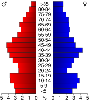
In the county, the population was spread out with 25.10% under the age of 18, 6.90% from 18 to 24, 27.60% from 25 to 44, 23.70% from 45 to 64, and 16.80% who were 65 years of age or older. The median age was 39 years. For every 100 females there were 100.70 males. For every 100 females age 18 and over, there were 101.40 males.
U.S. state
A U.S. state is any one of the 50 federated states of the United States of America that share sovereignty with the federal government. Because of this shared sovereignty, an American is a citizen both of the federal entity and of his or her state of domicile. Four states use the official title of...
of Wisconsin
Wisconsin
Wisconsin is a U.S. state located in the north-central United States and is part of the Midwest. It is bordered by Minnesota to the west, Iowa to the southwest, Illinois to the south, Lake Michigan to the east, Michigan to the northeast, and Lake Superior to the north. Wisconsin's capital is...
. As of 2000, the population was 13,804. Its county seat
County seat
A county seat is an administrative center, or seat of government, for a county or civil parish. The term is primarily used in the United States....
is Alma.
Geography
According to the U.S. Census BureauUnited States Census Bureau
The United States Census Bureau is the government agency that is responsible for the United States Census. It also gathers other national demographic and economic data...
, the county has a total area of 710 square miles (1,838.9 km²), of which 684 square miles (1,771.6 km²) is land and 25 square miles (64.7 km²) (3.54%) is water.
Adjacent counties
- Pepin County – north
- Eau Claire CountyEau Claire County, WisconsinEau Claire County is a county located in the U.S. state of Wisconsin. As of 2010, the population estimate was 98,736. Its county seat is Eau Claire....
– northeast - Trempealeau CountyTrempealeau County, WisconsinTrempealeau County is a county located in the U.S. state of Wisconsin. As of 2009, the population estimate was 27,754. Its county seat is Whitehall.-History:Patches of woodland are all that remain of the brush and light forest that once covered the county...
– east - Winona County, MinnesotaWinona County, MinnesotaAs of the census of 2000, there were 49,985 people, 18,744 households, and 11,696 families residing in the county. The population density was 80 people per square mile . There were 19,551 housing units at an average density of 31 per square mile...
– south - Wabasha County, MinnesotaWabasha County, MinnesotaAs of the census of 2000, there were 21,610 people, 8,277 households, and 5,876 families residing in the county. The population density was 41 people per square mile . There were 9,066 housing units at an average density of 17 per square mile...
– west
Major highways
|
 Highway 95 (Wisconsin) Highway 95 (Wisconsin)Highway 95 (Wisconsin) State Trunk Highway 95 is a state highway in the U.S. state of Wisconsin. It runs east–west in west-central Wisconsin from near Neillsville to Fountain City....  Highway 37 (Wisconsin) Highway 37 (Wisconsin)Highway 37 (Wisconsin) State Trunk Highway 37 is a state highway in the U.S. state of Wisconsin. It runs generally south-southwesterly through west-central Wisconsin from Eau Claire to Alma. The southern , from Mondovi to Alma, generally follows the course of the Buffalo River....  Highway 25 (Wisconsin) Highway 25 (Wisconsin) Highway 121 (Wisconsin) Highway 121 (Wisconsin)Highway 121 (Wisconsin) State Trunk Highway 121 is a state highway in the U.S. state of Wisconsin. It runs in east–west in west-central Wisconsin from Gilmanton to Alma Center.... |
 U.S. Highway 10


Demographics
As of the census
Census
A census is the procedure of systematically acquiring and recording information about the members of a given population. It is a regularly occurring and official count of a particular population. The term is used mostly in connection with national population and housing censuses; other common...
of 2000, there were 13,804 people, 5,511 households, and 3,780 families residing in the county. The population density
Population density
Population density is a measurement of population per unit area or unit volume. It is frequently applied to living organisms, and particularly to humans...
was 20 people per square mile (8/km²). There were 6,098 housing units at an average density of 9 per square mile (3/km²). The racial makeup of the county was 98.69% White
Race (United States Census)
Race and ethnicity in the United States Census, as defined by the Federal Office of Management and Budget and the United States Census Bureau, are self-identification data items in which residents choose the race or races with which they most closely identify, and indicate whether or not they are...
, 0.12% Black
Race (United States Census)
Race and ethnicity in the United States Census, as defined by the Federal Office of Management and Budget and the United States Census Bureau, are self-identification data items in which residents choose the race or races with which they most closely identify, and indicate whether or not they are...
or African American
Race (United States Census)
Race and ethnicity in the United States Census, as defined by the Federal Office of Management and Budget and the United States Census Bureau, are self-identification data items in which residents choose the race or races with which they most closely identify, and indicate whether or not they are...
, 0.30% Native American
Race (United States Census)
Race and ethnicity in the United States Census, as defined by the Federal Office of Management and Budget and the United States Census Bureau, are self-identification data items in which residents choose the race or races with which they most closely identify, and indicate whether or not they are...
, 0.33% Asian
Race (United States Census)
Race and ethnicity in the United States Census, as defined by the Federal Office of Management and Budget and the United States Census Bureau, are self-identification data items in which residents choose the race or races with which they most closely identify, and indicate whether or not they are...
, 0.02% Pacific Islander
Race (United States Census)
Race and ethnicity in the United States Census, as defined by the Federal Office of Management and Budget and the United States Census Bureau, are self-identification data items in which residents choose the race or races with which they most closely identify, and indicate whether or not they are...
, 0.08% from other races
Race (United States Census)
Race and ethnicity in the United States Census, as defined by the Federal Office of Management and Budget and the United States Census Bureau, are self-identification data items in which residents choose the race or races with which they most closely identify, and indicate whether or not they are...
, and 0.46% from two or more races. 0.62% of the population were Hispanic
Race (United States Census)
Race and ethnicity in the United States Census, as defined by the Federal Office of Management and Budget and the United States Census Bureau, are self-identification data items in which residents choose the race or races with which they most closely identify, and indicate whether or not they are...
or Latino
Race (United States Census)
Race and ethnicity in the United States Census, as defined by the Federal Office of Management and Budget and the United States Census Bureau, are self-identification data items in which residents choose the race or races with which they most closely identify, and indicate whether or not they are...
of any race. 44.3% were of German, 22.1% Norwegian and 8.8% Polish ancestry according to Census 2000. 96.9% spoke English
English language
English is a West Germanic language that arose in the Anglo-Saxon kingdoms of England and spread into what was to become south-east Scotland under the influence of the Anglian medieval kingdom of Northumbria...
, 1.6% Spanish
Spanish language
Spanish , also known as Castilian , is a Romance language in the Ibero-Romance group that evolved from several languages and dialects in central-northern Iberia around the 9th century and gradually spread with the expansion of the Kingdom of Castile into central and southern Iberia during the...
and 1.1% German
German language
German is a West Germanic language, related to and classified alongside English and Dutch. With an estimated 90 – 98 million native speakers, German is one of the world's major languages and is the most widely-spoken first language in the European Union....
as their first language.
There were 5,511 households out of which 30.80% had children under the age of 18 living with them, 58.90% were married couples
Marriage
Marriage is a social union or legal contract between people that creates kinship. It is an institution in which interpersonal relationships, usually intimate and sexual, are acknowledged in a variety of ways, depending on the culture or subculture in which it is found...
living together, 6.20% had a female householder with no husband present, and 31.40% were non-families. 27.10% of all households were made up of individuals and 12.60% had someone living alone who was 65 years of age or older. The average household size was 2.47 and the average family size was 3.01.
In the county, the population was spread out with 25.10% under the age of 18, 6.90% from 18 to 24, 27.60% from 25 to 44, 23.70% from 45 to 64, and 16.80% who were 65 years of age or older. The median age was 39 years. For every 100 females there were 100.70 males. For every 100 females age 18 and over, there were 101.40 males.
Cities, villages, and towns
Cities
- Alma
- Buffalo CityBuffalo City, WisconsinBuffalo City is a city in Buffalo County in the U.S. state of Wisconsin. The population was 1,040 at the 2000 census.-History:The name may be derived from a buffalo animal husbandry operation in the past. The city was chartered in 1868...
- Fountain CityFountain City, WisconsinFountain City is a city in Buffalo County in the U.S. state of Wisconsin. The population was 983 at the 2000 census.-History:Fountain City was originally called Holmes' Landing, after Thomas Holmes, who settled there in 1839...
- MondoviMondovi, WisconsinMondovi is a city in Buffalo County in the U.S. state of Wisconsin, along the Buffalo River. The population was 2,634 at the 2000 census. The city is located mostly within the Town of Mondovi...
Towns
|
Dover, Buffalo County, Wisconsin Dover is a town in Buffalo County in the U.S. state of Wisconsin. The population was 484 at the 2000 census. The unincorporated community of Lookout is located in the town.-Geography:... Lincoln, Buffalo County, Wisconsin Lincoln is a town in Buffalo County in the U.S. state of Wisconsin. The population was 187 at the 2000 census. The unincorporated communities of Cream, and Praag are located in the town.-Geography:... |
Milton, Buffalo County, Wisconsin Milton is a town in Buffalo County in the U.S. state of Wisconsin. The population was 517 at the 2000 census. The unincorporated community of Czechville is located in the town.-Geography:... |
|
Unincorporated communities
- Bluff SidingBluff Siding, WisconsinBluff Siding is an unincorporated community located in the town of Buffalo, in Buffalo County, Wisconsin, United States.-Notes:...
- CreamCream, WisconsinCream is an unincorporated community located in the town of Lincoln, in Buffalo County, Wisconsin. Cream is located on Wisconsin Highway 88 northeast of Cochrane....
- CzechvilleCzechville, WisconsinCzechville is an unincorporated community located in the town of Milton, in Buffalo County, Wisconsin, United States. Czechville is located at the junction of Wisconsin Highway 35 and Wisconsin Highway 88 southeast of Cochrane....
- East WinonaEast Winona, WisconsinEast Winona is an unincorporated community in Buffalo County, Wisconsin, United States, located where Canadian National Railway subsidiary Wisconsin Central Ltd.'s former Green Bay and Western Railroad line meets the BNSF Railway's St. Croix Subdivision. East Winona is located in the town of...
- GilmantonGilmanton (community), WisconsinGilmanton is an unincorporated community located in the town of Gilmanton, in Buffalo County, Wisconsin, United States. Gilmanton is located at the junction of Wisconsin Highway 88 and Wisconsin Highway 121 south of Mondovi. Gilmanton has a post office with ZIP code 54743....
- GlencoeGlencoe (community), WisconsinGlencoe is an unincorporated community located in the town of Glencoe, in Buffalo County, Wisconsin, United States. Glencoe is west-northwest of Arcadia....
- HeroldHerold, WisconsinHerold is an unincorporated community located in the town of Belvidere, in Buffalo County, Wisconsin, United States. Herold is located along County Highway E east-southeast of Alma....
- LookoutLookout, WisconsinLookout is an unincorporated community located in the town of Dover, in Buffalo County, Wisconsin, United States. Lookout is located on Wisconsin Highway 121 southeast of Mondovi....
- MarshlandMarshland, WisconsinMarshland is an unincorporated community located in the town of Buffalo, in Buffalo County, Wisconsin, United States. Marshland is located on Wisconsin Highway 35 and Wisconsin Highway 54 east-southeast of Fountain City....
- MaxvilleMaxville, WisconsinMaxville is a town in Buffalo County in the U.S. state of Wisconsin. The population was 325 at the 2000 census. The unincorporated community of Maxville is located in the town...
- Misha MokwaMisha Mokwa, WisconsinMisha Mokwa is an unincorporated community located in the town of Nelson, Buffalo County, Wisconsin, United States. Misha Mokwa is located along Wisconsin Highway 25 north of the village of Nelson....
- ModenaModena (community), WisconsinModena is an unincorporated community located in the town of Modena, in Buffalo County, Wisconsin, United States. Modena is located along County Highway J near its junction with County Highway D, southwest of Mondovi....
- MontanaMontana (community), WisconsinMontana is an unincorporated community located in the town of Montana, in Buffalo County, Wisconsin, United States. Montana is located at the junction of County Highways C and U northeast of Cochrane....
- PraagPraag, WisconsinPraag is an unincorporated community located in the town of Lincoln, in Buffalo County, Wisconsin, United States. Praag is located on Wisconsin Highway 88 east-northeast of Alma....
- TellTell, WisconsinTell is an unincorporated community located in the town of Alma, in Buffalo County, Wisconsin, United States. Tell is located on Wisconsin Highway 37 northeast of Alma....
- TrevinoTrevino, WisconsinTrevino is an unincorporated community located in the town of Nelson, in Buffalo County, Wisconsin, United States. Trevino is located on the BNSF Railway west of the village of Nelson....
- UrneUrne, WisconsinUrne is an unincorporated community located in the towns of Nelson and Modena, Buffalo County, Wisconsin, United States. Urne is located at the junction of County Highways F and K northeast of the village of Nelson....
- Waumandee
Ghost towns
- AnchorageAnchorage, WisconsinAnchorage is a ghost town in Buffalo County, Wisconsin, United States. Anchorage was located in the town of Waumandee southwest of the community of Waumandee....
- BohriBohri, WisconsinBohri is a ghost town in Buffalo County, Wisconsin, United States. Bohri was located in the town of Cross east of Fountain City....
- SavoySavoy, WisconsinSavoy is a ghost town in Buffalo County, Wisconsin, United States. Savoy was located in the town of Maxville near the Chippewa River, west-southwest of the community of Maxville....
- SpringdaleSpringdale, Buffalo County, WisconsinSpringdale is a ghost town in Buffalo County, Wisconsin, United States. Springdale was located in the town of Canton west-southwest of Mondovi....
See also
- National Register of Historic Places listings in Buffalo County, Wisconsin
- Trempealeau National Wildlife RefugeTrempealeau National Wildlife RefugeTrempealeau National Wildlife Refuge is a National Wildlife Refuge located along the Upper Mississippi River in extreme southern Buffalo County and extreme southwestern Trempealeau County in Wisconsin, USA....
- Upper Mississippi River National Wildlife and Fish RefugeUpper Mississippi River National Wildlife and Fish RefugeThe Upper Mississippi River National Wildlife and Fish Refuge is a . 261 river mile long National Wildlife Refuge located in and along the Upper Mississippi River. It runs from Wabasha, Minnesota in the north to Rock Island, Illinois in the south....