

ERAST Project
Encyclopedia
NASA
The National Aeronautics and Space Administration is the agency of the United States government that is responsible for the nation's civilian space program and for aeronautics and aerospace research...
program to develop cost-effective, slow-flying unmanned aerial vehicle
Unmanned aerial vehicle
An unmanned aerial vehicle , also known as a unmanned aircraft system , remotely piloted aircraft or unmanned aircraft, is a machine which functions either by the remote control of a navigator or pilot or autonomously, that is, as a self-directing entity...
s (UAVs) that can perform long-duration science missions at altitudes above 60,000 feet. The project included a number of different technology development programs which were conducted by the joint NASA-industry ERAST Alliance. The project was formally terminated in 2003.
Program overview
According to NASA, "ERAST is a multiyear effort to develop the aeronautical and sensor technologies for a new family of remotely piloted aircraft intended for upper atmospheric science missions. Designed to cruise at slow speeds for long durations at altitudes of 60,000 to 100,000 ft, such aircraft could be used to collect, identify, and monitor environmental data to assess global climate change and assist in weather monitoring and forecasting. They also could serve as airborne telecommunications platforms, performing functions similar to communications satellites at a fraction of the cost of lofting a satellite into space.""The ERAST program is sponsored by the Office of Aeronautics and Space Transportation Technology at NASA Headquarters, and is managed by NASA Dryden Flight Research Center
Dryden Flight Research Center
The Dryden Flight Research Center , located inside Edwards Air Force Base, is an aeronautical research center operated by NASA. On March 26, 1976 it was named in honor of the late Hugh L. Dryden, a prominent aeronautical engineer who at the time of his death in 1965 was NASA's deputy administrator...
. The NASA Ames Research Center, Moffett Field, California, heads the sensor technology development. The NASA Lewis Research Center, Cleveland, Ohio
Cleveland, Ohio
Cleveland is a city in the U.S. state of Ohio and is the county seat of Cuyahoga County, the most populous county in the state. The city is located in northeastern Ohio on the southern shore of Lake Erie, approximately west of the Pennsylvania border...
, and NASA Langley Research Center
Langley Research Center
Langley Research Center is the oldest of NASA's field centers, located in Hampton, Virginia, United States. It directly borders Poquoson, Virginia and Langley Air Force Base...
, Hampton, Virginia
Hampton, Virginia
Hampton is an independent city that is not part of any county in Southeast Virginia. Its population is 137,436. As one of the seven major cities that compose the Hampton Roads metropolitan area, it is on the southeastern end of the Virginia Peninsula. Located on the Hampton Roads Beltway, it hosts...
, are contributing expertise in the areas of propulsion, structures, and systems analysis. Several small high-technology aeronautical development firms, including ALTUS developer General Atomics Aeronautical Systems, Inc., are teamed with NASA in the ERAST Alliance to work towards common goals of the program."
Industry partners in the ERAST Alliance included Aurora Flight Systems, AeroVironment
AeroVironment
AeroVironment Inc. is a technology company in Monrovia, California, and Simi Valley, California, that is primarily involved in energy systems, electric vehicle systems, and unmanned aerial vehicles . Paul B. MacCready, Jr., a famous designer of human powered aircraft, founded the company in 1971...
, General Atomics
General Atomics
General Atomics is a nuclear physics and defense contractor headquartered in San Diego, California. General Atomics’ research into fission and fusion matured into competencies in related technologies, allowing the company to expand into other fields of research...
, Scaled Composites
Scaled Composites
Scaled Composites is an aerospace company founded by Burt Rutan and currently owned by Northrop Grumman that is located at the Mojave Spaceport, Mojave, California, United States...
, Thermo-Mechanical Systems, Hyperspectral Sciences, and Longitude 122 West.
The types of science mission which ERAST prepares for can include remote sensing for Earth sciences studies, hyperspectral imaging for agriculture monitoring, tracking of severe storms, and serving as telecommunications relay platforms.
A parallel effort headed by Ames developed lightweight, microminiaturized sensors that can be carried by these aircraft for environmental research and Earth monitoring.
Additional technologies considered by the ERAST Alliance include lightweight materials, avionics, aerodynamics, and other forms of propulsion suitable for extreme altitudes and duration.
Although ERAST Alliance members were responsible for aircraft development and operation, NASA had primary responsibility for overall program leadership, major funding, individual project management, development and coordination of payloads. NASA also worked on long-term issues with the Federal Aviation Administration and developed technology to make operation of these remotely operated aircraft in national airspace practical.
History
In 1987 and 1988, NASA conducted atmospheric ozone-layer depletion studies using two piloted NASA aircraft, a modified Douglas DC-8Douglas DC-8
The Douglas DC-8 is a four-engined narrow-body passenger commercial jet airliner, manufactured from 1958 to 1972 by the Douglas Aircraft Company...
jetliner and a Lockheed ER-2, a civilian version of the U-2 spy plane. However, operating the ER-2 over Antarctica, where ozone
Ozone
Ozone , or trioxygen, is a triatomic molecule, consisting of three oxygen atoms. It is an allotrope of oxygen that is much less stable than the diatomic allotrope...
depletion took place, was regarded as risky, since if the pilot had to bail out, survival was unlikely. In addition, the ER-2 had a ceiling of 20 kilometers (65,000 feet), while ozone depletion takes place at 30 kilometers (100,000 feet), and the ER-2 could not stay aloft long enough to study ozone changes during a full day-night cycle.
In 1988, NASA decided to obtain a HALE UAV named "Perseus" to deal with these problems, designating the effort the Small High-Altitude Science Aircraft (SHASA) program. Perseus was designed by a startup company named Aurora Flight Sciences
Aurora Flight Sciences
Aurora Flight Sciences specializes in the design and construction of unmanned aircraft. Aurora has been established for 20+ years and their headquarters is at the Manassas Airport in Manassas, VA.-History:...
of Manassas, Virginia
Manassas, Virginia
The City of Manassas is an independent city surrounded by Prince William County and the independent city of Manassas Park in the Commonwealth of Virginia in the United States. Its population was 37,821 as of 2010. Manassas also surrounds the county seat for Prince William County but that county...
. The Perseus design effort struggled along on skimpy funds until 1991, when NASA was conducting a "High Speed Research Program" to evaluate designs for a future supersonic transport, and needed to learn more about the possible environmental impact of such an aircraft on the upper atmosphere. Funds became available to procure a few aircraft.
Other government agencies were also interested in HALE UAVs, and so the ERAST effort was born in September 1994 as a high-profile item in NASA'a agenda. ERAST was formally intended to promote the use of UAVs in commercial science applications, particularly high-altitude atmospheric research. ERAST also has focused on development of new miniaturized sensor and avionics systems for the UAVs and for NASA's Lockheed ER-2.
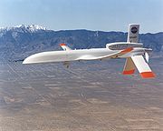
ALTUS
General Atomics ALTUS
- External links :* * *...
is a civilian variant of the MQ-1 Predator UAV designed for scientific research missions. One of the two ALTUS aircraft, ALTUS II, was built under the ERAST program and has participated in a number of the related research missions.
The ALTUS II made its first flight on May 1, 1996. With its engine at first augmented by a single-stage turbocharger, the ALTUS II reached an altitude of 37,000 ft during its first series of development flights at Dryden in August, 1996. In October of that year, the ALTUS II was flown in an Atmospheric Radiation Measurement
Atmospheric Radiation Measurement
The United States Department of Energy's Atmospheric Radiation Measurement Program was created in 1989 to develop several highly instrumented ground stations to study cloud formation processes and their influence on radiative transfer...
(ARM-UAV) study in Oklahoma conducted by Sandia National Laboratories
Sandia National Laboratories
The Sandia National Laboratories, managed and operated by the Sandia Corporation , are two major United States Department of Energy research and development national laboratories....
for the Department of Energy. During the course of those flights, the ALTUS II set a single-flight endurance record for remotely operated aircraft of more than 26 hours. In October 1996, ALTUS II set an endurance record for UAVs carrying science payloads. The vehicle spent more than 24 hours at the required altitude during an ARM-UAV.
After major modifications and upgrades, including installation of a two-stage turbocharger in place of its original single-stage unit, a larger fuel tank and additional intercooling capacity, the ALTUS II returned to flight status in the summer of 1998. The goal of its development test flights was to reach one of the major ERAST Level 2 performance milestones, to fly a gasoline-fueled, piston-engine remotely piloted aircraft for several hours at an altitude at or near 60,000 feet. On March 5, 1999, The ALTUS II maintained flight at or above 55,000 feet for three hours, reaching a maximum density altitude of 57,300 feet during the mission.
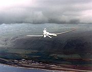
Pathfinder and Helios

Fuel cell
A fuel cell is a device that converts the chemical energy from a fuel into electricity through a chemical reaction with oxygen or another oxidizing agent. Hydrogen is the most common fuel, but hydrocarbons such as natural gas and alcohols like methanol are sometimes used...
system
System
System is a set of interacting or interdependent components forming an integrated whole....
-powered UAVs which AeroVironment, Inc.
AeroVironment
AeroVironment Inc. is a technology company in Monrovia, California, and Simi Valley, California, that is primarily involved in energy systems, electric vehicle systems, and unmanned aerial vehicles . Paul B. MacCready, Jr., a famous designer of human powered aircraft, founded the company in 1971...
developed the vehicle under the ERAST program.
Pathfinder, which was designed and built by AeroVironment
AeroVironment
AeroVironment Inc. is a technology company in Monrovia, California, and Simi Valley, California, that is primarily involved in energy systems, electric vehicle systems, and unmanned aerial vehicles . Paul B. MacCready, Jr., a famous designer of human powered aircraft, founded the company in 1971...
, is essentially a flying wing
Flying wing
A flying wing is a tailless fixed-wing aircraft which has no definite fuselage, with most of the crew, payload and equipment being housed inside the main wing structure....
with a 99 foot span. Solar photovoltaic cells
Photovoltaics
Photovoltaics is a method of generating electrical power by converting solar radiation into direct current electricity using semiconductors that exhibit the photovoltaic effect. Photovoltaic power generation employs solar panels composed of a number of solar cells containing a photovoltaic material...
mounted on the top of the wing produce up to 7,200 watts, powering the aircraft's six electric-driven propellers, as well as the suite of scientific instruments. Backup batteries store solar energy to power the aircraft at night.
ARTIS camera
A small Airborne Real-Time Imaging System (ARTIS) camera, developed by HyperSpectral Sciences, Inc., under ERAST project, was flight demonstrated during the summer of 1999 on board the Scaled Composites ProteusScaled Composites Proteus
The Scaled Composites Model 281 Proteus is a tandem-wing high-endurance aircraft designed by Burt Rutan to investigate the use of aircraft as high altitude telecommunications relays. The Proteus is actually a multi-mission vehicle, able to carry various payloads on a ventral pylon...
aircraft when it took visual and near-infrared
Infrared
Infrared light is electromagnetic radiation with a wavelength longer than that of visible light, measured from the nominal edge of visible red light at 0.74 micrometres , and extending conventionally to 300 µm...
photos from Proteus while it was flying high over the Experimental Aircraft Association
Experimental Aircraft Association
The Experimental Aircraft Association is an international organization of aviation enthusiasts based in Oshkosh, Wisconsin. Since its inception it has grown internationally with over 160,000 members and about 1,000 chapters worldwide....
's AirVenture 99
Oshkosh Airshow
EAA AirVenture Oshkosh is America's largest annual gathering of aviation enthusiasts held each summer at Wittman Regional Airport in Oshkosh, Wisconsin, United States....
Airshow at Oshkosh, Wisconsin
Oshkosh, Wisconsin
As of the census of 2000, there were 62,916 people, 24,082 households, and 13,654 families residing in the city. The population density was 2,662.2 people per square mile . There were 25,420 housing units at an average density of 1,075.6 per square mile...
. The images were displayed on a computer monitor at the show only moments after they were taken.
DASI
The Digital Array Scanned Interferometer (DASI) was operated from the Pathfinder in the summer of 1997, acquiring imaging interferometric data of the Hawaiian Islands. The DASI, which originated at Washington University and was jointly developed with Ames Research Center, had to meet the stringent engineering and operating requirements of the Pathfinder with respect to remote operation, very light weight, and low volume, power and bandwidth.DSA
In March 2002, NASA Dryden, in cooperation with New Mexico State UniversityNew Mexico State University
New Mexico State University at Las Cruces , is a major land-grant university in Las Cruces, New Mexico, United States...
's Technical Analysis and Applications Center (TAAC), the FAA and several other entities, conducted flight demonstrations of an active detect, see and avoid (DSA) system for potential application to UAVs at Las Cruces, New Mexico
Las Cruces, New Mexico
Las Cruces, also known as "The City of the Crosses", is the county seat of Doña Ana County, New Mexico, United States. The population was 97,618 in 2010 according to the 2010 Census, making it the second largest city in the state....
. The Scaled Composites Proteus
Scaled Composites Proteus
The Scaled Composites Model 281 Proteus is a tandem-wing high-endurance aircraft designed by Burt Rutan to investigate the use of aircraft as high altitude telecommunications relays. The Proteus is actually a multi-mission vehicle, able to carry various payloads on a ventral pylon...
aircraft was flown as a surrogate UAV controlled remotely from the ground, although safety pilots were aboard to handle takeoff and landing and any potential emergencies. Three other aircraft, ranging from general aviation aircraft to a NASA F/A-18, served as "cooperative" target aircraft with an operating transponder. In each of 18 different scenarios, a Goodrich
Goodrich Corporation
The Goodrich Corporation , formerly the B.F. Goodrich Company, is an American aerospace manufacturing company based in Charlotte, North Carolina. Founded in Akron, Ohio in 1870 as Goodrich, Tew & Co. by Dr. Benjamin Franklin Goodrich. The company name was changed to the "B.F...
Skywatch HP Traffic Advisory System (TAS) on the Proteus detected approaching air traffic on potential collision courses, including several scenarios with two aircraft approaching from different directions. The remote pilot then directed Proteus to turn, climb or descend as needed to avoid the potential threat.
In April 2003, a second series of flight demonstrations focusing on "non-cooperative" aircraft (those without operating transponders), was conducted in restricted airspace near Mojave, California
Mojave, California
Mojave is a census-designated place in Kern County, California, United States. Mojave is located east of Bakersfield, at an elevation of 2762 feet...
., again using the Proteus as a surrogate UAV. Proteus was equipped with a small Amphitech OASys 35 GHz primary radar system to detect potential intruder aircraft on simulated collision courses. The radar data was telemetered directly to the ground station as well as via an Inmarsat
International Mobile Satellite Organization
The International Mobile Satellite Organization is the intergovernmental organization that oversees certain public satellite safety and security communication services provided via the Inmarsat satellites...
satellite system installed on Proteus. A mix of seven intruder aircraft, ranging from a sailplane to a high-speed jet, flew 20 scenarios over a four-day period, one or two aircraft at a time. In each case, the radar picked up the intruding aircraft at ranges from 2.5 to 6.5 miles, depending on the intruder's radar signature. Proteus' remote pilot on the ground was able to direct Proteus to take evasive action if needed.
See also
- NASA Mini-SnifferNASA Mini-SnifferThe NASA Mini-Sniffers were a series of unmanned aerial vehicles designed to sample the air at high altitude to support various scientific studies.-History:...
- Airborne Science ProgramAirborne Science ProgramNASA's Airborne Science Program is administered from the NASA Dryden Flight Research Center, in Edwards, California. The program supports the sub-orbital flight requirements of NASA's Earth Science Enterprise...
- NASA Earth Science EnterpriseNASA Earth Science EnterpriseThe NASA Earth Science Enterprise , formerly called Mission To Planet Earth , is a NASA research program "to develop a scientific understanding of the Earth system and its response to natural and human-induced changes to enable improved prediction of climate, weather, and natural hazards for...
(formerly "Mission to Planet Earth")
External links
- Katzberg, Stephen J. "Performance Assessment of the Digital Array Scanned Interferometer Concept", NASA Technical Paper 3570, August 1996
- Hammer, Philip D, et al., "Surface Reflectance Mapping Using Interferometric Spectral Imagery from a Remotely Piloted Aircraft"
- Pathfinder mission page, no longer active at NASA, archived at archive.org
- Pathfinder/Helios