

Delaware Route 9
Encyclopedia
Delaware Route 9 is a 58 miles (93.3 km) state highway that connects with Delaware Route 1 at the Dover Air Force Base
(only just less than a mile south of the southern terminus of the Korean War Veterans Memorial Highway) to Interstate 95
in the City of Wilmington
. Much like their U.S. Highway counterparts (Delaware State Routes, with some exceptions, follow the AASHTO system used for numbering U.S. highways), Delaware Route 9 runs east of Delaware Route 1, but unlike the more heavily-traveled DE 1, DE 9 is a designated scenic highway known as the Route 9 Coastal Heritage Scenic Byway south of New Castle
, and also has a commercial truck restriction between Dover A.F.B. and Delaware City
. Delaware's Coastal Heritage Greenway
follows much of Delaware Route 9 south of Wilmington, linking many important sites along the Delaware Bay
.
DE 9 was first designated by 1936 to run from US 113
(now DE 1) southeast of Dover north to US 13 in Smyrna
, following its current alignment to Leipsic and Smyrna-Leipsic Road to Smyrna. In the 1950s, the road was extended to US 13 Alternate (now US 13) in Wilmington, in which it was rerouted at Leipsic to follow its current alignment to Wilmington. DE 9 was extended further north to DE 2 by the 1970s. The route was rerouted to bypass downtown New Castle in the 1980s. The intersection with DE 1 was reconstructed into an interchange in 2009.
terminus (Exit 92) and is in part a two-lane, undivided road that goes through most of the marshlands that make up the Delaware Bay
watershed. From the southern terminus north to New Castle, DE 9 is designated as the Route 9 Coastal Heritage Scenic Byway, a road that is part of the Delaware Scenic and Historic Highways
system and is noted for following the Delaware River
and Delaware Bay shoreline. Past the Dover A.F.B. area, DE 9 goes through the towns of Little Creek
, where it intersects DE 8
, and Leipsic
, where it intersects DE 42
, crossing several tributaries of the Delaware Bay on either low or high fixed crossings. North of Leipsic, DE 9 passes through the Bombay Hook National Wildlife Refuge
which has significant populations of nesting Bald Eagle
s, taking advantage of the populations of brackish water
striped bass
and fresh water sunfish that reside in the area.
Past Bombay Hook, the road intersects DE 6
and then crosses over the Smyrna River on a high-level crossing (this was a drawbridge
in the past) and then splits off south of Odessa
with DE 299
. The road, after crossing over several more tidal rivers, then draws up to the headwaters of the Delaware Bay, at Augustine Beach, in which the Salem Nuclear Power Plant
in New Jersey
can be easily seen. DE 9 then enters the small town of Port Penn
, heads briefly west, then turns north toward Delaware City.
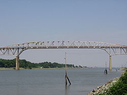 Past Port Penn, DE 9 continues north through the Delaware marshlands on a more modern two lane road with emergency shoulders. For four miles (6 km), the road crisscrosses with several swamps and drainage canals until the road crosses the Chesapeake and Delaware Canal
on the Reedy Point Bridge
. Opened in 1966, the high-level crossing replaced a vertical-lift drawbridge as part of the 1960s canal improvement project that eliminated all locks on the canal and also built both the Summit Bridge
(U.S. Route 301
and Delaware Routes 71
and 896) and the Canal Lift Bridge
for the Pennsylvania Railroad
.
North of the canal itself, the road then crosses over both Fort Dupont
and the Governor Bacon Health Center before entering Delaware City itself. Just past the canal, but before Delaware City, DE 9 crosses over the Delaware City Channel, which was before the 1920s, the eastern terminus of the C & D Canal. The Delaware City Channel, which connects the present-day canal with the Delaware River, serves as a marina, but access to the canal is restricted because the drawbridge, which DE 9 uses, is currently out of service. After going through Delaware City, the road then continues north and curves west to the intersection with DE 72
at the Delaware City Oil Refinery, at which point the commercial truck restrictions end.
and then enters New Castle
near a tidal retention gate. In New Castle, DE 9 intersects with two state routes, DE 273, which connects New Castle with Rising Sun, Maryland
and DE 141
, which bypasses Wilmington to the west. DE 9 then, for the first time, becomes a four-lane road and then intersects with I-295
and US 40
at the base of the Delaware Memorial Bridge
, I-495
(via DE 9A) at the Port of Wilmington
, and then US 13
in Wilmington. DE 9 continues with US 13 into Downtown Wilmington, where, just past the Christina River
drawbridge and a low-clearance underpass for Amtrak
's Northeast Corridor
, US 13 breaks off. DE 9 then continues through the downtown business district on Fourth Street before crossing under I-95
and terminating at DE 2 in the city's Little Italy
district.
was upgraded to a state highway. In addition, the current alignment of DE 9 around Taylors Bridge and between Delaware City and Wilmington was paved. By 1932, what would become DE 9 between the Kitts Hummock area and Leipsic was upgraded to a state highway, along with the road between Port Penn and Delaware City and New Castle and Wilmington. When Delaware assigned state route numbers by 1936, DE 9 was designated to run from US 113
(now DE 1) west of Kitts Hummock north to US 13 in Smyrna, following its current alignment to Leipsic and Smyrna-Leipsic Road to Smyrna. By 1942, what is now DE 9 between the Taylors Bridge area and Port Penn was paved. DE 9 was extended north to US 13 Alternate (now US 13) in Wilmington by 1959, being rerouted off Smyrna-Leipsic Road to follow its current alignment to New Castle, passing through that city on 6th Street before continuing along its current alignment to Wilmington. At this point, the entire route was paved. The current Reedy Point Bridge carrying DE 9 over the Chesapeake and Delaware Canal was completed in 1968. By 1971, DE 9 was extended north to its current terminus at DE 2. DE 9 was realigned to bypass New Castle by 1984 by following Washington Street and DE 273. The intersection at the southern terminus with DE 1 was rebuilt into an interchange in 2009.
!County
!Location
!Milepost
!Intersecting road
!Notes
|-
|rowspan=4|Kent
|Dover Air Force Base
|0.00
|
|Interchange, southern terminus
|-
|Little Creek
|
|
|
|-
|Leipsic
|11.46
|
|
|-
|
|16.49
|
|
|-
|rowspan=14|New Castle
|Mathews Corner
|30.18
|
|
|-
|colspan=5 align="center"|Reedy Point Bridge
over Chesapeake and Delaware Canal
|-
|Delaware City
|43.00
|
|
|-
|
|45.46
|
|
|-
|New Castle
|50.14
|
|
|-
|Wilmington Manor
|53.31
|, New Jersey
-New York
, Baltimore
|Interchange
|-
|rowspan=8|Wilmington
|55.87
|, Baltimore
|South end of US 13 overlap
|-
|56.07
|
|
|-
|56.37
|
|North end of US 13 northbound overlap
|-
|56.45
|
|North end of US 13 southbound overlap
|-
|56.73
|
|
|-
|56.84
|
|
|-
|
|
|Interchange
|-
|58.21
|
|Northern terminus
|-
as well as provide access to I-495
, the main Interstate highway in Delaware to Philadelphia and Baltimore.
The road begins as a four-lane highway called Terminal Avenue at Delaware Route 9 just past the I-495 underpass north of the I-295
/US 40
interchange at the Delaware Memorial Bridge
, crossing underneath of I-495 less than ¼ mi. east of the road's terminus. Past I-495, the road, still four lanes, then crosses over Norfolk Southern's (former Penn Central and Conrail) Delmarva Branch at a grade crossing before making a sharp left turn at the entrance to the Port of Wilmington. At this point, DelDOT officially marks the end of the route, but signage shows it turning north onto Christiana Avenue.
The road then proceeds due north, crossing under I-495 again (this time underneath of the I-495 bridge over the Christina River
, as well as crossing over both of NS Delmarva and Shellpot Branch
es (both grade crossings) before terminating at both US 13
and DE 9 near the Christina River
drawbridge leading into Wilmington's Central Business District.
What is now DE 9A was originally a county road by 1920. By 1924, the Christiana Avenue portion of the route was constructed as a state highway. Christiana Avenue became a portion of US 40 in 1926, which used the road from US 13 to a ferry that went across the Delaware River to Penns Grove, New Jersey
. By 1931, US 40 was removed from this road. The road became the easternmost portion of DE 48
by 1936, which crossed the Delaware River on the ferry to connect to New Jersey Route 48 in Penns Grove. DE 48 was removed from this road by 1949 when the ferry between Wilmington and Penns Grove was discontinued. DE 9A was designated by 1971 onto its current alignment.
. It heads west from DE 9 on Hamburg Road to Tybouts Corner
, where it turns north on U.S. Route 13
. It heads north along with US 13, with U.S. Route 40
joining in State Road, to Hares Corner, where it turns east onto Delaware Route 273. It follows DE 273 toward New Castle where it returns to DE 9 at the intersection between that route, DE 273 and Delaware Route 141
.
Dover Air Force Base
Dover Air Force Base or Dover AFB is a United States Air Force base located two miles southeast of the city of Dover, Delaware.-Units:...
(only just less than a mile south of the southern terminus of the Korean War Veterans Memorial Highway) to Interstate 95
Interstate 95 in Delaware
In Delaware, Interstate 95 runs diagonally from the border with Maryland northeast to the border with Pennsylvania. Between the Maryland state line and exit 5, I-95 is also designated as the Delaware Turnpike and the John F. Kennedy Memorial Highway. Along with its auxiliaries, I-95 is the only...
in the City of Wilmington
Wilmington, Delaware
Wilmington is the largest city in the state of Delaware, United States, and is located at the confluence of the Christina River and Brandywine Creek, near where the Christina flows into the Delaware River. It is the county seat of New Castle County and one of the major cities in the Delaware Valley...
. Much like their U.S. Highway counterparts (Delaware State Routes, with some exceptions, follow the AASHTO system used for numbering U.S. highways), Delaware Route 9 runs east of Delaware Route 1, but unlike the more heavily-traveled DE 1, DE 9 is a designated scenic highway known as the Route 9 Coastal Heritage Scenic Byway south of New Castle
New Castle, Delaware
New Castle is a city in New Castle County, Delaware, six miles south of Wilmington, situated on the Delaware River. In 1900, 3,380 people lived here; in 1910, 3,351...
, and also has a commercial truck restriction between Dover A.F.B. and Delaware City
Delaware City, Delaware
Delaware City is a city in New Castle County, Delaware, United States. The population was 1,695 at the 2010 census. It is a small port town on the eastern terminus of the Chesapeake and Delaware Canal and is the location of the ferry to Fort Delaware on Pea Patch Island.-Geography:Delaware City is...
. Delaware's Coastal Heritage Greenway
Coastal Heritage Greenway
The Coastal Heritage Greenway is a greenway in the U.S. state of Delaware linking many sites along the Delaware Bay and the Atlantic Ocean between Fox Point State Park in Edgemoor, New Castle County and the beach town of Fenwick Island in Sussex County...
follows much of Delaware Route 9 south of Wilmington, linking many important sites along the Delaware Bay
Delaware Bay
Delaware Bay is a major estuary outlet of the Delaware River on the Northeast seaboard of the United States whose fresh water mixes for many miles with the waters of the Atlantic Ocean. It is in area. The bay is bordered by the State of New Jersey and the State of Delaware...
.
DE 9 was first designated by 1936 to run from US 113
U.S. Route 113
U.S. Route 113 is a spur of US 13 in the U.S. states of Maryland and Delaware. The U.S. Highway runs from US 13 in Pocomoke City, Maryland north to Delaware Route 1 in Milford, Delaware...
(now DE 1) southeast of Dover north to US 13 in Smyrna
Smyrna, Delaware
Smyrna is a town in Kent and New Castle counties in the U.S. state of Delaware. It is part of the Dover, Delaware Metropolitan Statistical Area...
, following its current alignment to Leipsic and Smyrna-Leipsic Road to Smyrna. In the 1950s, the road was extended to US 13 Alternate (now US 13) in Wilmington, in which it was rerouted at Leipsic to follow its current alignment to Wilmington. DE 9 was extended further north to DE 2 by the 1970s. The route was rerouted to bypass downtown New Castle in the 1980s. The intersection with DE 1 was reconstructed into an interchange in 2009.
Dover A.F.B. to Port Penn
DE 9 begins at an interchange with DE 1 just south of the toll roadToll road
A toll road is a privately or publicly built road for which a driver pays a toll for use. Structures for which tolls are charged include toll bridges and toll tunnels. Non-toll roads are financed using other sources of revenue, most typically fuel tax or general tax funds...
terminus (Exit 92) and is in part a two-lane, undivided road that goes through most of the marshlands that make up the Delaware Bay
Delaware Bay
Delaware Bay is a major estuary outlet of the Delaware River on the Northeast seaboard of the United States whose fresh water mixes for many miles with the waters of the Atlantic Ocean. It is in area. The bay is bordered by the State of New Jersey and the State of Delaware...
watershed. From the southern terminus north to New Castle, DE 9 is designated as the Route 9 Coastal Heritage Scenic Byway, a road that is part of the Delaware Scenic and Historic Highways
Delaware Scenic and Historic Highways
The Delaware Scenic and Historic Highways system consists of roads in the U.S. state of Delaware that travel through areas of scenic and historic interest...
system and is noted for following the Delaware River
Delaware River
The Delaware River is a major river on the Atlantic coast of the United States.A Dutch expedition led by Henry Hudson in 1609 first mapped the river. The river was christened the South River in the New Netherland colony that followed, in contrast to the North River, as the Hudson River was then...
and Delaware Bay shoreline. Past the Dover A.F.B. area, DE 9 goes through the towns of Little Creek
Little Creek, Delaware
Little Creek is a town in Kent County, Delaware, United States. It is part of the Dover, Delaware Metropolitan Statistical Area. It is part of the Dover, Delaware Metropolitan Statistical Area. The population was 224 at the 2010 census...
, where it intersects DE 8
Delaware Route 8
Delaware Route 8 is a state highway located in Kent County, Delaware. It runs from Maryland Route 454 at the Maryland border near Marydel, Maryland east to an intersection with Delaware Route 9 north of Little Creek. The route passes through the heart of Delaware's capital, Dover, on Division...
, and Leipsic
Leipsic, Delaware
Leipsic is a town in Kent County, Delaware, United States. It is part of the Dover, Delaware Metropolitan Statistical Area. The population was 183 at the 2010 census.-Geography:Leipsic is located at ....
, where it intersects DE 42
Delaware Route 42
Delaware Route 42 is a state highway in Kent County, Delaware. It runs from Delaware Route 6 in Blackiston to Delaware Route 9 in Leipsic. Delaware Route 42 passes through the towns of Kenton and Cheswold along the way. The road was built as a state highway during the 1920s and 1930s...
, crossing several tributaries of the Delaware Bay on either low or high fixed crossings. North of Leipsic, DE 9 passes through the Bombay Hook National Wildlife Refuge
Bombay Hook National Wildlife Refuge
The Bombay Hook National Wildlife Refuge is a 15,978 acre National Wildlife Refuge located along the eastern coast of Kent County, Delaware, on Delaware Bay. It was established on March 16, 1937 as a refuge and breeding ground for migratory and wintering waterfowl along the Atlantic Flyway...
which has significant populations of nesting Bald Eagle
Bald Eagle
The Bald Eagle is a bird of prey found in North America. It is the national bird and symbol of the United States of America. This sea eagle has two known sub-species and forms a species pair with the White-tailed Eagle...
s, taking advantage of the populations of brackish water
Brackish water
Brackish water is water that has more salinity than fresh water, but not as much as seawater. It may result from mixing of seawater with fresh water, as in estuaries, or it may occur in brackish fossil aquifers. The word comes from the Middle Dutch root "brak," meaning "salty"...
striped bass
Striped bass
The striped bass is the state fish of Maryland, Rhode Island, South Carolina, and the state saltwater fish of New York, Virginia, and New Hampshire...
and fresh water sunfish that reside in the area.
Past Bombay Hook, the road intersects DE 6
Delaware Route 6
Delaware Route 6 is a state highway in Kent County, Delaware. It runs from Maryland Route 291 at the Maryland border west of Blackiston to the Delaware Bay in Woodland Beach. The route passes through rural areas of northern Kent County as well as the towns of Smyrna and Clayton. DE 6 intersects...
and then crosses over the Smyrna River on a high-level crossing (this was a drawbridge
Drawbridge
A drawbridge is a type of movable bridge typically associated with the entrance of a castle surrounded by a moat. The term is often used to describe all different types of movable bridges, like bascule bridges and lift bridges.-Castle drawbridges:...
in the past) and then splits off south of Odessa
Odessa, Delaware
Odessa is a town in New Castle County, Delaware, United States. The population was 364 at the 2010 census. Originally founded as Cantwell's Bridge in the 18th century, the name was changed in the 19th century, after the Ukrainian port city of the same name...
with DE 299
Delaware Route 299
Delaware Route 299 is a state highway in New Castle County, Delaware. It runs from Maryland Route 282 at the Maryland border east of Warwick, Maryland to DE 9 in Mathews Corner, passing through Middletown and Odessa. It overlaps US 301 from just east of the Maryland border to the west end of...
. The road, after crossing over several more tidal rivers, then draws up to the headwaters of the Delaware Bay, at Augustine Beach, in which the Salem Nuclear Power Plant
Salem Nuclear Power Plant
The Salem Nuclear Power Plant is a two unit pressurized water reactor nuclear power station located in Lower Alloways Creek Township, New Jersey, in the United States. It is owned by PSEG Nuclear LLC and Exelon Generation LLC....
in New Jersey
New Jersey
New Jersey is a state in the Northeastern and Middle Atlantic regions of the United States. , its population was 8,791,894. It is bordered on the north and east by the state of New York, on the southeast and south by the Atlantic Ocean, on the west by Pennsylvania and on the southwest by Delaware...
can be easily seen. DE 9 then enters the small town of Port Penn
Port Penn, Delaware
Port Penn is an unincorporated community located in southern New Castle County, Delaware below the Chesapeake and Delaware Canal. Port Penn is home to the Port Penn Interpretive Center....
, heads briefly west, then turns north toward Delaware City.
Port Penn to Delaware City
Chesapeake and Delaware Canal
The Chesapeake and Delaware Canal is a 14-mile long, 450-foot wide and 40-foot deep ship canal that cuts across the states of Maryland and Delaware, in the United States. It connects the waters of the Delaware River with those of the Chesapeake Bay and the Port of Baltimore...
on the Reedy Point Bridge
Reedy Point Bridge
The Reedy Point Bridge carries Delaware Route 9 across the Chesapeake & Delaware Canal in Delaware City, Delaware, USA. A two-lane cantilever bridge similar in appearance to the Platt Bridge in Southwest Philadelphia , the Reedy Point Bridge was built by the U.S...
. Opened in 1966, the high-level crossing replaced a vertical-lift drawbridge as part of the 1960s canal improvement project that eliminated all locks on the canal and also built both the Summit Bridge
Summit Bridge
The Summit Bridge carries U.S. Route 301 and Delaware Routes 71 and 896 across the Chesapeake & Delaware Canal, connecting Newark, Delaware with Dover, Delaware and the Chesapeake Bay Bridge . The bridge also carries Delaware Bicycle Route 1, a bicycle route that spans the length of the state of...
(U.S. Route 301
U.S. Route 301
U.S. Route 301 is a spur of U.S. Route 1 running through the South Atlantic States. It currently runs 1,099 miles from Glasgow, Delaware at U.S. Route 40 to Sarasota, Florida. It passes through the states of Delaware, Maryland, Virginia, North Carolina, South Carolina, Georgia, and Florida...
and Delaware Routes 71
Delaware Route 71
Delaware Route 71 is a state highway in New Castle County, Delaware. The route loops off U.S. Route 13 from south of Townsend to Tybouts Corner, traveling to the west of US 13 by way of Townsend, Middletown, and the Summit Bridge...
and 896) and the Canal Lift Bridge
Chesapeake & Delaware Canal Lift Bridge
The Chesapeake & Delaware Canal Lift Bridge carries Norfolk Southern rail lines across the Chesapeake & Delaware Canal. Built by the U.S. Army Corps of Engineers as part of a canal expansion project and opened in 1966, the Canal Lift Bridge, the only drawbridge on the C & D Canal was...
for the Pennsylvania Railroad
Pennsylvania Railroad
The Pennsylvania Railroad was an American Class I railroad, founded in 1846. Commonly referred to as the "Pennsy", the PRR was headquartered in Philadelphia, Pennsylvania....
.
North of the canal itself, the road then crosses over both Fort Dupont
Fort Dupont
Fort Dupont is a residential neighborhood located in southeast Washington, D.C, east of the Anacostia River. It is bounded by East Capitol Street to the north, Fort Dupont Park to the south, Minnesota Avenue to the west, and Fort Chaplin Park to the east and northeast.Fort Dupont is adjacent to...
and the Governor Bacon Health Center before entering Delaware City itself. Just past the canal, but before Delaware City, DE 9 crosses over the Delaware City Channel, which was before the 1920s, the eastern terminus of the C & D Canal. The Delaware City Channel, which connects the present-day canal with the Delaware River, serves as a marina, but access to the canal is restricted because the drawbridge, which DE 9 uses, is currently out of service. After going through Delaware City, the road then continues north and curves west to the intersection with DE 72
Delaware Route 72
Delaware Route 72 is a state highway located in New Castle County, Delaware. The route runs from Delaware Route 9 near Delaware City to Delaware Route 7 in Pike Creek. Parts of DE 72 were built as a state highway during the 1940s. By the 1940s, the route was designated between DE 2 and DE 7 along...
at the Delaware City Oil Refinery, at which point the commercial truck restrictions end.
Delaware City to Wilmington
DE 9 turns right at the beginning of DE 72, thus going north again. DE 9 continues north through the Valero Oil Refinery complex, with its northern boundaries at the Red Lion Creek bridge. After crossing Red Lion Creek, the road passes the northern training grounds for the Delaware National GuardUnited States National Guard
The National Guard of the United States is a reserve military force composed of state National Guard militia members or units under federally recognized active or inactive armed force service for the United States. Militia members are citizen soldiers, meaning they work part time for the National...
and then enters New Castle
New Castle, Delaware
New Castle is a city in New Castle County, Delaware, six miles south of Wilmington, situated on the Delaware River. In 1900, 3,380 people lived here; in 1910, 3,351...
near a tidal retention gate. In New Castle, DE 9 intersects with two state routes, DE 273, which connects New Castle with Rising Sun, Maryland
Rising Sun, Maryland
Rising Sun is a town in Cecil County, Maryland, United States. The population was 1,702 at the 2000 census.-Overview:Rising Sun is located at ....
and DE 141
Delaware Route 141
Delaware Route 141 is a bypass around the western suburbs of Wilmington, Delaware. Its northern terminus is an interchange with U.S. Route 202 and Delaware Route 261 in Fairfax, and its southern terminus is at Delaware Route 9 and Delaware Route 273 in New Castle...
, which bypasses Wilmington to the west. DE 9 then, for the first time, becomes a four-lane road and then intersects with I-295
Interstate 295 (Delaware-New Jersey)
Interstate 295 in New Jersey and Delaware is an auxiliary Interstate Highway, designated as a bypass around Philadelphia, Pennsylvania. The route begins at a junction with Interstate 95 south of Wilmington, Delaware, and runs to another junction with I-95 north of Trenton, New Jersey...
and US 40
U.S. Route 40 in Delaware
U.S. Route 40 serves as a major east–west highway in northern New Castle County, Delaware, just south of Wilmington. It runs from the Maryland border east of Elkton, Maryland east through the rapidly growing towns of Glasgow and Bear before following U.S...
at the base of the Delaware Memorial Bridge
Delaware Memorial Bridge
The Delaware Memorial Bridge is a set of twin suspension bridges crossing the Delaware River. The toll bridges carry Interstate 295 and U.S. Route 40 between Delaware and New Jersey...
, I-495
Interstate 495 (Delaware)
Interstate 495 in Delaware is a six-lane bypass of Interstate 95 around the city of Wilmington, Delaware. Built in the mid-1970s and opened as the "Wilmington Bypass", the highway became, between 1978 and 1982, the route of I-95 around Wilmington, while the original highway through the city,...
(via DE 9A) at the Port of Wilmington
Port of Wilmington (Delaware)
The Port of Wilmington is a deep-water port located at the confluence of the Christina River and the Delaware River in Wilmington, Delaware, from the Atlantic Ocean...
, and then US 13
U.S. Route 13 in Delaware
U.S. Route 13 is the main north–south highway in the U.S. state of Delaware. It traverses the entire length of the state from the Maryland border in Delmar, Sussex County to the Pennsylvania border in Claymont, New Castle County. U.S. Route 13 connects many important cities and towns in...
in Wilmington. DE 9 continues with US 13 into Downtown Wilmington, where, just past the Christina River
Christina River
The Christina River is a tributary of the Delaware River, approximately 35 miles long, in northern Delaware in the United States, also flowing through small areas of southeastern Pennsylvania and northeastern Maryland. Near its mouth the river flows past downtown Wilmington, Delaware,...
drawbridge and a low-clearance underpass for Amtrak
Amtrak
The National Railroad Passenger Corporation, doing business as Amtrak , is a government-owned corporation that was organized on May 1, 1971, to provide intercity passenger train service in the United States. "Amtrak" is a portmanteau of the words "America" and "track". It is headquartered at Union...
's Northeast Corridor
Northeast Corridor
The Northeast Corridor is a fully electrified railway line owned primarily by Amtrak serving the Northeast megalopolis of the United States from Boston in the north, via New York to Washington, D.C. in the south, with branches serving other cities...
, US 13 breaks off. DE 9 then continues through the downtown business district on Fourth Street before crossing under I-95
Interstate 95 in Delaware
In Delaware, Interstate 95 runs diagonally from the border with Maryland northeast to the border with Pennsylvania. Between the Maryland state line and exit 5, I-95 is also designated as the Delaware Turnpike and the John F. Kennedy Memorial Highway. Along with its auxiliaries, I-95 is the only...
and terminating at DE 2 in the city's Little Italy
Little Italy, Wilmington
Little Italy is a neighborhood on the west side of Wilmington, Delaware.Little Italy is bounded roughly by 4th Street to the south, Union Street to the west, Clayton Street to the east, and Pennsylvania Avenue to the north. Like other neighborhoods with the "Little Italy" designation, Little Italy...
district.
History
What would become DE 9 originally existed as a county road by 1920. By 1924, the road between Leipsic and SmyrnaSmyrna, Delaware
Smyrna is a town in Kent and New Castle counties in the U.S. state of Delaware. It is part of the Dover, Delaware Metropolitan Statistical Area...
was upgraded to a state highway. In addition, the current alignment of DE 9 around Taylors Bridge and between Delaware City and Wilmington was paved. By 1932, what would become DE 9 between the Kitts Hummock area and Leipsic was upgraded to a state highway, along with the road between Port Penn and Delaware City and New Castle and Wilmington. When Delaware assigned state route numbers by 1936, DE 9 was designated to run from US 113
U.S. Route 113
U.S. Route 113 is a spur of US 13 in the U.S. states of Maryland and Delaware. The U.S. Highway runs from US 13 in Pocomoke City, Maryland north to Delaware Route 1 in Milford, Delaware...
(now DE 1) west of Kitts Hummock north to US 13 in Smyrna, following its current alignment to Leipsic and Smyrna-Leipsic Road to Smyrna. By 1942, what is now DE 9 between the Taylors Bridge area and Port Penn was paved. DE 9 was extended north to US 13 Alternate (now US 13) in Wilmington by 1959, being rerouted off Smyrna-Leipsic Road to follow its current alignment to New Castle, passing through that city on 6th Street before continuing along its current alignment to Wilmington. At this point, the entire route was paved. The current Reedy Point Bridge carrying DE 9 over the Chesapeake and Delaware Canal was completed in 1968. By 1971, DE 9 was extended north to its current terminus at DE 2. DE 9 was realigned to bypass New Castle by 1984 by following Washington Street and DE 273. The intersection at the southern terminus with DE 1 was rebuilt into an interchange in 2009.
Major intersections
{|class=wikitable!County
!Location
!Milepost
!Intersecting road
!Notes
|-
|rowspan=4|Kent
Kent County, Delaware
Kent County is a county located in the central part of the U.S. state of Delaware. It is coextensive with the Dover, Delaware, Metropolitan Statistical Area. As of 2010 the population was 162,310, a 28.1% increase over the previous decade. The county seat is Dover, the state capital...
|Dover Air Force Base
Dover Air Force Base
Dover Air Force Base or Dover AFB is a United States Air Force base located two miles southeast of the city of Dover, Delaware.-Units:...
|0.00
|
|Interchange, southern terminus
|-
|Little Creek
Little Creek, Delaware
Little Creek is a town in Kent County, Delaware, United States. It is part of the Dover, Delaware Metropolitan Statistical Area. It is part of the Dover, Delaware Metropolitan Statistical Area. The population was 224 at the 2010 census...
|
|
|
|-
|Leipsic
Leipsic, Delaware
Leipsic is a town in Kent County, Delaware, United States. It is part of the Dover, Delaware Metropolitan Statistical Area. The population was 183 at the 2010 census.-Geography:Leipsic is located at ....
|11.46
|
|
|-
|
|16.49
|
|
|-
|rowspan=14|New Castle
New Castle County, Delaware
New Castle County is the northernmost of the three counties of the U.S. state of Delaware. As of 2010 its population was 538,479, an increase of 7.6% over the previous decade. The county seat is Wilmington. The center of population of Delaware is located in New Castle County, in the town of...
|Mathews Corner
|30.18
|
|
|-
|colspan=5 align="center"|Reedy Point Bridge
Reedy Point Bridge
The Reedy Point Bridge carries Delaware Route 9 across the Chesapeake & Delaware Canal in Delaware City, Delaware, USA. A two-lane cantilever bridge similar in appearance to the Platt Bridge in Southwest Philadelphia , the Reedy Point Bridge was built by the U.S...
over Chesapeake and Delaware Canal
Chesapeake and Delaware Canal
The Chesapeake and Delaware Canal is a 14-mile long, 450-foot wide and 40-foot deep ship canal that cuts across the states of Maryland and Delaware, in the United States. It connects the waters of the Delaware River with those of the Chesapeake Bay and the Port of Baltimore...
|-
|Delaware City
Delaware City, Delaware
Delaware City is a city in New Castle County, Delaware, United States. The population was 1,695 at the 2010 census. It is a small port town on the eastern terminus of the Chesapeake and Delaware Canal and is the location of the ferry to Fort Delaware on Pea Patch Island.-Geography:Delaware City is...
|43.00
|
|
|-
|
|45.46
|
|
|-
|New Castle
New Castle, Delaware
New Castle is a city in New Castle County, Delaware, six miles south of Wilmington, situated on the Delaware River. In 1900, 3,380 people lived here; in 1910, 3,351...
|50.14
|
|
|-
|Wilmington Manor
Wilmington Manor, Delaware
Wilmington Manor is a census-designated place in north-eastern New Castle County, Delaware, United States. The population was 8,262 at the 2000 census.-Geography:Wilmington Manor is located at...
|53.31
|, New Jersey
New Jersey
New Jersey is a state in the Northeastern and Middle Atlantic regions of the United States. , its population was 8,791,894. It is bordered on the north and east by the state of New York, on the southeast and south by the Atlantic Ocean, on the west by Pennsylvania and on the southwest by Delaware...
-New York
New York
New York is a state in the Northeastern region of the United States. It is the nation's third most populous state. New York is bordered by New Jersey and Pennsylvania to the south, and by Connecticut, Massachusetts and Vermont to the east...
, Baltimore
Baltimore
Baltimore is the largest independent city in the United States and the largest city and cultural center of the US state of Maryland. The city is located in central Maryland along the tidal portion of the Patapsco River, an arm of the Chesapeake Bay. Baltimore is sometimes referred to as Baltimore...
|Interchange
|-
|rowspan=8|Wilmington
Wilmington, Delaware
Wilmington is the largest city in the state of Delaware, United States, and is located at the confluence of the Christina River and Brandywine Creek, near where the Christina flows into the Delaware River. It is the county seat of New Castle County and one of the major cities in the Delaware Valley...
|55.87
|, Baltimore
Baltimore
Baltimore is the largest independent city in the United States and the largest city and cultural center of the US state of Maryland. The city is located in central Maryland along the tidal portion of the Patapsco River, an arm of the Chesapeake Bay. Baltimore is sometimes referred to as Baltimore...
|South end of US 13 overlap
|-
|56.07
|
|
|-
|56.37
|
|North end of US 13 northbound overlap
|-
|56.45
|
|North end of US 13 southbound overlap
|-
|56.73
|
|
|-
|56.84
|
|
|-
|
|
|Interchange
|-
|58.21
|
|Northern terminus
|-
DE 9A
Delaware Route 9A is a 4/5 mi. (1.25 km.) two to four lane road that serves as the primary access route to the Port of WilmingtonPort of Wilmington (Delaware)
The Port of Wilmington is a deep-water port located at the confluence of the Christina River and the Delaware River in Wilmington, Delaware, from the Atlantic Ocean...
as well as provide access to I-495
Interstate 495 (Delaware)
Interstate 495 in Delaware is a six-lane bypass of Interstate 95 around the city of Wilmington, Delaware. Built in the mid-1970s and opened as the "Wilmington Bypass", the highway became, between 1978 and 1982, the route of I-95 around Wilmington, while the original highway through the city,...
, the main Interstate highway in Delaware to Philadelphia and Baltimore.
The road begins as a four-lane highway called Terminal Avenue at Delaware Route 9 just past the I-495 underpass north of the I-295
Interstate 295 (Delaware-New Jersey)
Interstate 295 in New Jersey and Delaware is an auxiliary Interstate Highway, designated as a bypass around Philadelphia, Pennsylvania. The route begins at a junction with Interstate 95 south of Wilmington, Delaware, and runs to another junction with I-95 north of Trenton, New Jersey...
/US 40
U.S. Route 40 in Delaware
U.S. Route 40 serves as a major east–west highway in northern New Castle County, Delaware, just south of Wilmington. It runs from the Maryland border east of Elkton, Maryland east through the rapidly growing towns of Glasgow and Bear before following U.S...
interchange at the Delaware Memorial Bridge
Delaware Memorial Bridge
The Delaware Memorial Bridge is a set of twin suspension bridges crossing the Delaware River. The toll bridges carry Interstate 295 and U.S. Route 40 between Delaware and New Jersey...
, crossing underneath of I-495 less than ¼ mi. east of the road's terminus. Past I-495, the road, still four lanes, then crosses over Norfolk Southern's (former Penn Central and Conrail) Delmarva Branch at a grade crossing before making a sharp left turn at the entrance to the Port of Wilmington. At this point, DelDOT officially marks the end of the route, but signage shows it turning north onto Christiana Avenue.
The road then proceeds due north, crossing under I-495 again (this time underneath of the I-495 bridge over the Christina River
Christina River
The Christina River is a tributary of the Delaware River, approximately 35 miles long, in northern Delaware in the United States, also flowing through small areas of southeastern Pennsylvania and northeastern Maryland. Near its mouth the river flows past downtown Wilmington, Delaware,...
, as well as crossing over both of NS Delmarva and Shellpot Branch
Shellpot Branch
The Shellpot Branch is a former Pennsylvania Railroad/Penn Central through-freight railroad owned and operated by Norfolk Southern since its acquisition, along with CSX Transportation, of Conrail in 1999...
es (both grade crossings) before terminating at both US 13
U.S. Route 13 in Delaware
U.S. Route 13 is the main north–south highway in the U.S. state of Delaware. It traverses the entire length of the state from the Maryland border in Delmar, Sussex County to the Pennsylvania border in Claymont, New Castle County. U.S. Route 13 connects many important cities and towns in...
and DE 9 near the Christina River
Christina River
The Christina River is a tributary of the Delaware River, approximately 35 miles long, in northern Delaware in the United States, also flowing through small areas of southeastern Pennsylvania and northeastern Maryland. Near its mouth the river flows past downtown Wilmington, Delaware,...
drawbridge leading into Wilmington's Central Business District.
What is now DE 9A was originally a county road by 1920. By 1924, the Christiana Avenue portion of the route was constructed as a state highway. Christiana Avenue became a portion of US 40 in 1926, which used the road from US 13 to a ferry that went across the Delaware River to Penns Grove, New Jersey
Penns Grove, New Jersey
Penns Grove is a Borough in Salem County, New Jersey, United States. As of the 2000 United States Census, the borough population was 4,886.Penns Grove was incorporated as a borough by an Act of the New Jersey Legislature on March 8, 1894, from portions of Upper Penns Neck Township Penns Grove is a...
. By 1931, US 40 was removed from this road. The road became the easternmost portion of DE 48
Delaware Route 48
Delaware Route 48 connects the City of Wilmington, Delaware to an intersection with Delaware Route 41 about from the Pennsylvania state line in Hockessin, Delaware....
by 1936, which crossed the Delaware River on the ferry to connect to New Jersey Route 48 in Penns Grove. DE 48 was removed from this road by 1949 when the ferry between Wilmington and Penns Grove was discontinued. DE 9A was designated by 1971 onto its current alignment.
DE 9 Truck
Delaware Route 9 Truck is a truck bypass of a stretch of DE 9 south of New CastleNew Castle, Delaware
New Castle is a city in New Castle County, Delaware, six miles south of Wilmington, situated on the Delaware River. In 1900, 3,380 people lived here; in 1910, 3,351...
. It heads west from DE 9 on Hamburg Road to Tybouts Corner
Tybouts Corner, Delaware
Tybouts Corner is an unincorporated populated place in New Castle County, Delaware, United States. It is located at the intersection of US Route 13 and Hamburg Road/Bear Tybouts Road at and has an elevation of 55 feet....
, where it turns north on U.S. Route 13
U.S. Route 13
U.S. Route 13 is a north–south U.S. highway established in 1926 that runs for from Interstate 95 just north of Fayetteville, North Carolina to the northeastern suburbs of Philadelphia, Pennsylvania, in Morrisville. In all, it traverses five states in the Atlantic coastal plain region,...
. It heads north along with US 13, with U.S. Route 40
U.S. Route 40
U.S. Route 40 is an east–west United States highway. As with most routes whose numbers end in a zero, U.S. 40 once traversed the entire United States. It is one of the original 1920s U.S. Highways, and its first termini were San Francisco, California, and Atlantic City, New Jersey...
joining in State Road, to Hares Corner, where it turns east onto Delaware Route 273. It follows DE 273 toward New Castle where it returns to DE 9 at the intersection between that route, DE 273 and Delaware Route 141
Delaware Route 141
Delaware Route 141 is a bypass around the western suburbs of Wilmington, Delaware. Its northern terminus is an interchange with U.S. Route 202 and Delaware Route 261 in Fairfax, and its southern terminus is at Delaware Route 9 and Delaware Route 273 in New Castle...
.