
Daniel Campos Province
Encyclopedia
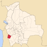
Daniel Campos is a province
in the north-western parts of the Bolivia
n Potosí Department
. It is named after the poet Daniel Campos who originated from this area. Its capital is Llica
.
and between 66° 49' and 68° 47' West
. It borders Oruro Department
in the north, the Republic of Chile
in the west, Nor Lípez Province
in the south, and Antonio Quijarro Province
in the east.
The province extends over 240 km from east to west and 180 km from north to south.
, more than 65 % of the province being covered by Salar de Uyuni
. Salar de Uyuni is situated at an average level of 3,657 m amsl
, the highest point of the province is Alto Totoni (5,740 m) in Cordillera Sillaguay on the Chile
nean border. The climate is that of an arid
high mountain region, with yearly precipitation of below 200 mm, even less than 100 mm in the extreme west. Average daily temperatures are 0 to 5 °C all over the year.
which are partly further subdivided into cantons
.
, spoken by 80%, while 59% of the population speak Aymara
. The population increased from 4,630 inhabitants (1992 census) to 5,067 (2001 census), an increase of 9.4%.
87% of the population have no access to electricity, 91% have no sanitary facilities. 73% of the population are employed in agriculture, 3% in mining, 2% in industry, 22% in general services. 87% of the population are Catholics, 8% Protestants.
The people are predominantly indigenous
citizens of Aymara descent.
Province
A province is a territorial unit, almost always an administrative division, within a country or state.-Etymology:The English word "province" is attested since about 1330 and derives from the 13th-century Old French "province," which itself comes from the Latin word "provincia," which referred to...
in the north-western parts of the Bolivia
Bolivia
Bolivia officially known as Plurinational State of Bolivia , is a landlocked country in central South America. It is the poorest country in South America...
n Potosí Department
Potosí Department
Potosí Department is a department in southwestern Bolivia. It comprises 118,218 km² with 709,013 inhabitants . The capital is the city of Potosí....
. It is named after the poet Daniel Campos who originated from this area. Its capital is Llica
Llica
-History:There is evidence to suggest that this small village has existed for over 500 years, probably since before the discovery of America , for the Indians of southeastern the current Bolivia established brands dedicated to the cultivation of Pope, To provide food to the caravans crossing the...
.
Location
Daniel Campos province is one of sixteen provinces in the Potosí Department. It is located between 19° 25' and 20° 50' SouthLatitude
In geography, the latitude of a location on the Earth is the angular distance of that location south or north of the Equator. The latitude is an angle, and is usually measured in degrees . The equator has a latitude of 0°, the North pole has a latitude of 90° north , and the South pole has a...
and between 66° 49' and 68° 47' West
Longitude
Longitude is a geographic coordinate that specifies the east-west position of a point on the Earth's surface. It is an angular measurement, usually expressed in degrees, minutes and seconds, and denoted by the Greek letter lambda ....
. It borders Oruro Department
Oruro Department
Oruro is a department in Bolivia, with an area of 53,588 km². Its capital is the city of Oruro. At the time of census 2001 it had a population of 391,870.- Provinces of Oruro :...
in the north, the Republic of Chile
Chile
Chile ,officially the Republic of Chile , is a country in South America occupying a long, narrow coastal strip between the Andes mountains to the east and the Pacific Ocean to the west. It borders Peru to the north, Bolivia to the northeast, Argentina to the east, and the Drake Passage in the far...
in the west, Nor Lípez Province
Nor Lípez Province
Nor Lípez is a province in the Bolivian department of Potosí. Its seat is Colcha "K", also called Villa Martín. The majority of the province's area was titled as the Nor Lípez Native Community Land on 19 April 2011...
in the south, and Antonio Quijarro Province
Antonio Quijarro Province
Antonio Quijarro is a province in the central parts of the Bolivian Potosí Department situated at the Salar de Uyuni. Its seat is Uyuni.-Location:Antonio Quijarro province is one of sixteen provinces in the Potosí Department...
in the east.
The province extends over 240 km from east to west and 180 km from north to south.
Geography
The province is situated in the salt flats of southern AltiplanoAltiplano
The Altiplano , in west-central South America, where the Andes are at their widest, is the most extensive area of high plateau on Earth outside of Tibet...
, more than 65 % of the province being covered by Salar de Uyuni
Salar de Uyuni
Salar de Uyuni is the world's largest salt flat at . It is located in the Potosí and Oruro departments in southwest Bolivia, near the crest of the Andes, and is elevated above the mean sea level. The Salar was formed as a result of transformations between several prehistoric lakes...
. Salar de Uyuni is situated at an average level of 3,657 m amsl
Above mean sea level
The term above mean sea level refers to the elevation or altitude of any object, relative to the average sea level datum. AMSL is used extensively in radio by engineers to determine the coverage area a station will be able to reach...
, the highest point of the province is Alto Totoni (5,740 m) in Cordillera Sillaguay on the Chile
Chile
Chile ,officially the Republic of Chile , is a country in South America occupying a long, narrow coastal strip between the Andes mountains to the east and the Pacific Ocean to the west. It borders Peru to the north, Bolivia to the northeast, Argentina to the east, and the Drake Passage in the far...
nean border. The climate is that of an arid
Arid
A region is said to be arid when it is characterized by a severe lack of available water, to the extent of hindering or even preventing the growth and development of plant and animal life...
high mountain region, with yearly precipitation of below 200 mm, even less than 100 mm in the extreme west. Average daily temperatures are 0 to 5 °C all over the year.
Division
The province comprises two municipalitiesMunicipalities of Bolivia
Municipalities in Bolivia are administrative divisions of the entire national territory governed by local elections. Municipalities are the third level of administrative divisions, below departments and provinces. Some of the provinces consist of only one municipality...
which are partly further subdivided into cantons
Cantons of Bolivia
||On the level below municipalities, Bolivia is divided into cantons ....
.
| Section | Municipality | Seat |
|---|---|---|
| 1st | Llica Municipality Llica Municipality Llica Municipality is the first municipal section of the Daniel Campos Province in the Potosí Department in Bolivia. Its seat is Llica.The municipality is situated on the western side of the Salar de Uyuni bordering Tahua Municipality... |
Llica Llica -History:There is evidence to suggest that this small village has existed for over 500 years, probably since before the discovery of America , for the Indians of southeastern the current Bolivia established brands dedicated to the cultivation of Pope, To provide food to the caravans crossing the... |
| 2nd | Tahua Municipality Tahua Municipality Tahua Municipality is the second municipal section of the Daniel Campos Province in the Potosí Department in Bolivia. Its seat is Tahua.- Subdivision :The municipality consists of the following cantons:* Ayque* Cacoma* Caquena* Coqueza* Tahua* Yonza... |
Tahua |
Population
The main language of the province is SpanishSpanish language
Spanish , also known as Castilian , is a Romance language in the Ibero-Romance group that evolved from several languages and dialects in central-northern Iberia around the 9th century and gradually spread with the expansion of the Kingdom of Castile into central and southern Iberia during the...
, spoken by 80%, while 59% of the population speak Aymara
Aymara language
Aymara is an Aymaran language spoken by the Aymara people of the Andes. It is one of only a handful of Native American languages with over three million speakers. Aymara, along with Quechua and Spanish, is an official language of Peru and Bolivia...
. The population increased from 4,630 inhabitants (1992 census) to 5,067 (2001 census), an increase of 9.4%.
87% of the population have no access to electricity, 91% have no sanitary facilities. 73% of the population are employed in agriculture, 3% in mining, 2% in industry, 22% in general services. 87% of the population are Catholics, 8% Protestants.
The people are predominantly indigenous
Indigenous peoples of the Americas
The indigenous peoples of the Americas are the pre-Columbian inhabitants of North and South America, their descendants and other ethnic groups who are identified with those peoples. Indigenous peoples are known in Canada as Aboriginal peoples, and in the United States as Native Americans...
citizens of Aymara descent.
| Ethnic group | Llica Municipality (%) | Tahua Municipality (%) |
|---|---|---|
| Quechua | 5.7 | 6.0 |
| Aymara | 86.9 | 90.5 |
| Guaraní, Chiquitos Chiquitos Chiquitos means "little ones" in Spanish. The Spanish Conquistadores chose this name for the people living in the rain savannas of what is now the eastern parts of the Santa Cruz Department in Bolivia, when they found the small doors of the Indian huts in the region.Today, this area is called Gran... , Moxos Moxos people The Moxos, also known as the Mojos, are an indigenous people living around the head-waters of the Madeira River in northern Bolivia, particularly on both banks of the Mamore River. They submitted to Inca domination, but in 1564 gallantly repulsed the Spaniards. A century later, however, the Jesuits... |
0.1 | 0.1 |
| Not indigenous Indigenous peoples of the Americas The indigenous peoples of the Americas are the pre-Columbian inhabitants of North and South America, their descendants and other ethnic groups who are identified with those peoples. Indigenous peoples are known in Canada as Aboriginal peoples, and in the United States as Native Americans... |
7.1 | 3.3 |
| Other indigenous groups | 0.3 | 0.0 |
Places of interest
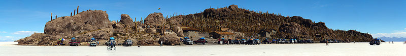
- Salar de Uyuni with the islands of InkawasiIncahuasi IslandInkahuasi or Inkawasi is an island in the middle of Salar de Uyuni in the Potosí Department in Bolivia, situated in the Daniel Campos Province, Tahua Municipality, Yonza Canton....
and Isla del PescadoIsla del PescadoIsla del Pescado, Isla de los Pescadores or Cujiri is an island in the middle of Salar de Uyuni in Bolivia, situated in the Daniel Campos Province, Tahua Municipality, Caquena Canton....
which are situated within the province