
Grey Knotts
Encyclopedia
Fell
“Fell” is a word used to refer to mountains, or certain types of mountainous landscape, in Scandinavia, the Isle of Man, and parts of northern England.- Etymology :...
in the English
England
England is a country that is part of the United Kingdom. It shares land borders with Scotland to the north and Wales to the west; the Irish Sea is to the north west, the Celtic Sea to the south west, with the North Sea to the east and the English Channel to the south separating it from continental...
Lake District
Lake District
The Lake District, also commonly known as The Lakes or Lakeland, is a mountainous region in North West England. A popular holiday destination, it is famous not only for its lakes and its mountains but also for its associations with the early 19th century poetry and writings of William Wordsworth...
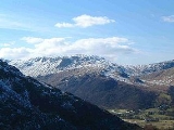
, it is situated one kilometre south of the B5289 road as it crosses the Honister Pass, it is well seen from mid Borrowdale
Borrowdale
Borrowdale is a valley and civil parish in the English Lake District in the Borough of Allerdale in Cumbria, England.Borrowdale lies within the historic county boundaries of Cumberland, and is sometimes referred to as Cumberland Borrowdale in order to distinguish it from another Borrowdale in the...
as it rises above Seatoller. Grey Knotts reaches a height of 697 metres (2287 feet) and is part of a ridge which ascends from the woodland behind Seatoller and continues south-west and then south for four kilometres to Great Gable
Great Gable
Great Gable is a mountain lying at the very heart of the English Lake District, appearing as a pyramid from Wasdale , but as a dome from most other directions. It is one of the most popular of the Lakeland fells, and there are many different routes to the summit...
. The fell's name really only applies to the summit rocks but has been adopted for the entire fell with the high ground in this area locally known as Seatoller Fell on Ordnance Survey
Ordnance Survey
Ordnance Survey , an executive agency and non-ministerial government department of the Government of the United Kingdom, is the national mapping agency for Great Britain, producing maps of Great Britain , and one of the world's largest producers of maps.The name reflects its creation together with...
maps.
Topography
Grey Knotts is a “Wainwright” fell and also qualifies as a Nuttall but this must be a borderline case as it barely has the required 15 metres of prominenceTopographic prominence
In topography, prominence, also known as autonomous height, relative height, shoulder drop , or prime factor , categorizes the height of the mountain's or hill's summit by the elevation between it and the lowest contour line encircling it and no higher summit...
to the adjoining higher fell of Brandreth.
All the highlights of Grey Knotts are situated on the eastern (Borrowdale) side of the fell, Raven Crag, known as Gillercombe Buttress to rock climbers
Climbing
Climbing is the activity of using one's hands and feet to ascend a steep object. It is done both for recreation and professionally, as part of activities such as maintenance of a structure, or military operations.Climbing activities include:* Bouldering: Ascending boulders or small...
, it is a popular area for bouldering
Bouldering
Bouldering is a style of rock climbing undertaken without a rope and normally limited to very short climbs over a crash pad so that a fall will not result in serious injury. It is typically practiced on large natural boulders or artificial boulders in gyms and outdoor urban areas...
using the large amount of large boulders that have become detached from the main crag, there are also several conventional climbing routes up the main crag. Gillercomb (spelt like this on map) is a fine example of a hanging valley from which issues the stream of Sour Milk Gill which descends into Borrowdale in a series of picturesque cascades.
Geology
The principal rock types are the plagioclasePlagioclase
Plagioclase is an important series of tectosilicate minerals within the feldspar family. Rather than referring to a particular mineral with a specific chemical composition, plagioclase is a solid solution series, more properly known as the plagioclase feldspar series...
-phyric andesite
Andesite
Andesite is an extrusive igneous, volcanic rock, of intermediate composition, with aphanitic to porphyritic texture. In a general sense, it is the intermediate type between basalt and dacite. The mineral assemblage is typically dominated by plagioclase plus pyroxene and/or hornblende. Magnetite,...
lava
Lava
Lava refers both to molten rock expelled by a volcano during an eruption and the resulting rock after solidification and cooling. This molten rock is formed in the interior of some planets, including Earth, and some of their satellites. When first erupted from a volcanic vent, lava is a liquid at...
s of the Birker Fell Formation.
Graphite Mine
Also on the Borrowdale side of the fell at the upper end of Newhouse Gill at grid reference is the site of the former Borrowdale graphiteGraphite
The mineral graphite is one of the allotropes of carbon. It was named by Abraham Gottlob Werner in 1789 from the Ancient Greek γράφω , "to draw/write", for its use in pencils, where it is commonly called lead . Unlike diamond , graphite is an electrical conductor, a semimetal...
(then called Plumbago) mines. The mine was started in the 16th century by German immigrants; the graphite found was in a very pure form and in those early days was used only for marking sheep. Later, however, graphite was found to be suitable for lining the casting moulds for cannon and musket balls, which caused its value to soar in the 17th century, as England, France and Holland built up their armies. The graphite was also used in pencil
Pencil
A pencil is a writing implement or art medium usually constructed of a narrow, solid pigment core inside a protective casing. The case prevents the core from breaking, and also from marking the user’s hand during use....
making, which in 1790 led to the founding of the Cumberland pencil industry based in Keswick
Keswick, Cumbria
Keswick is a market town and civil parish within the Borough of Allerdale in Cumbria, England. It had a population of 4,984, according to the 2001 census, and is situated just north of Derwent Water, and a short distance from Bassenthwaite Lake, both in the Lake District National Park...
. The mine closed in 1891 after new techniques meant that graphite no longer needed to be so pure, so the Borrowdale mine became uneconomic.
Ascents
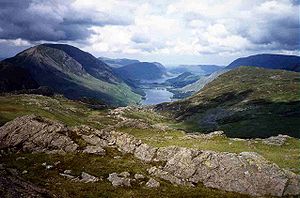
Grey Knotts can be ascended from Seathwaite or Seatoller in Borrowdale or from the top of the Honister Pass. The route from Seathwaite goes up Newhouse Gill thus allowing the walker to inspect the old graphite mines while the path from Seatoller has to use the B5289 road for a kilometre before going onto the fell and following a wall for some distance then climbing the northern end of Raven Crag to reach the summit. Grey Knotts is often climbed from the top of the Honister Pass which gives the advantage of starting at a height of 356 metres (1167 feet). Walkers often use Grey Knotts as a stepping stone for the ascent of Great Gable from Honister Pass also passing over the adjoining fells of Brandreth and Green Gable on the way.Summit and view
The top of the fell is dotted with grey tors of rock and two of these give the fell twin tops of equal height, the eastern top has an Ordnance Survey trig pointTrig point
A triangulation station, also known as a triangulation pillar, trigonometrical station, trigonometrical point, trig station, trig beacon or trig point, and sometimes informally as a trig, is a fixed surveying station, used in geodetic surveying and other surveying projects in its vicinity...
. There are also several small tarns
Tarn (lake)
A tarn is a mountain lake or pool, formed in a cirque excavated by a glacier. A moraine may form a natural dam below a tarn. A corrie may be called a cirque.The word is derived from the Old Norse word tjörn meaning pond...
on the summit as well as some fence posts which can be an aid to navigation. The view from the summit is very good with the Buttermere valley well seen to the north west and the Scafell massif standing out to the south.