
Cyclone Kamba
Encyclopedia
Intense Tropical Cyclone Kamba (JTWC
designation: 23S) was a powerful tropical cyclone
which remained out over the open waters of the south-central Indian Ocean
for its entire existence. The fourth and final intense tropical cyclone of the 2007-08 South-West Indian Ocean cyclone season
, Kamba developed out of an area of disturbed weather just outside Météo France's area of responsibility on March 5. Over the next several days, the system intensified, becoming a moderate tropical storm, at which time it was named Kamba, late on March 8. rapid intensification
followed shortly after with Kamba becoming an intense tropical cyclone around 1200 UTC
on March 10. Shortly thereafter, the cyclone moved over cooler waters and into a less favorable environment. By March 12, Kamba rapidly degenerated into a remnant-low pressure area and dissipated two days later.
for the southwest Indian Ocean, Météo-France
, began monitoring an area of disturbed weather located just outside their area of responsibility. At 0000 UTC
, the system was classified as a tropical disturbance. Operationally, Météo France did not begin issuing advisories on the disturbance until it had crossed 90°E
. Early on March 7, the Joint Typhoon Warning Center
(JTWC) issued a Tropical Cyclone Formation Alert
for the disturbance as they anticipated it to develop into a tropical cyclone with 24 hours. Although the center of circulation
was partially exposed, deep convection
was developing on the western half of the storm as the vertical wind shear
, which previously caused to low to become exposed, began to weaken. Later that day, Météo France upgraded the disturbance to a tropical depression. About three hours after being classified as a depression, the JTWC began issuing advisories on Tropical Cyclone 23S as they estimated winds to have reached 75 km/h (45 mph 1-minute winds).
Late on March 8, the depression was upgraded to a moderate tropical storm as 10-minute sustained winds reached 65 km/h (40 mph). Wind shear continued to impact the organization of the system as the eastern portion of the storm remained partially exposed. Shortly after, the storm was given the name Kamba by the Meteorological service in Mauritius
, a name contributed by the Comoros
. Tracking towards the southwest, Kamba quickly intensified into a severe tropical storm at 1200 UTC on March 9 as winds increased to 95 km/h (60 mph 10-minute winds). Not long after being upgraded to a severe tropical storm, the JTWC estimated that Kamba had strengthened into the equivalent of a Category 1 hurricane with winds of 120 km/h (75 mph). Early on March 10, Kamba began to undergo rapid intensification
and Météo-France upgraded the storm to a tropical cyclone as an eye developed. At this time, Kamba also started to turn towards the south as it tracked around the northwestern edge of a strong subtropical
ridge
.
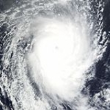
With low wind shear, Kamba continued to intensify throughout the first half of March 10, reaching its peak intensity with winds of 185 km/h (115 mph 10-minute winds) with a minimum pressure of 930 hPa
(mbar
) at 1200 UTC according to Météo-France. Kamba developed a 46 km (28 mi) wide eye as it reached peak intensity. Shortly after, the JTWC upgraded Kamba to a Category 4 equivalent cyclone with winds of 215 km/h (135 mph 1-minute winds). By March 11, Kamba began to move over cooler waters and into an area of higher wind shear, causing the storm to deteriorate. About 24 hours after reaching peak intensity, the storm began to undergo an extratropical transition
and weakened to a tropical cyclone. Early on March 12, the JTWC issued their final advisory on Kamba as it rapidly weakened over open waters. At the same time, Météo-France further downgraded the cyclone to a severe tropical storm as winds dropped below 120 km/h (75 mph 10-minute winds). Kamba further weakened to a moderate tropical storm as convection associated with the storm significantly diminished. The final advisory by Météo-France was issued shortly after as the storm degenerated into a remnant-low pressure area
. The remnants of Kamba persisted for a few more days before ultimately dissipating at 0600 UTC on March 14.
Joint Typhoon Warning Center
The Joint Typhoon Warning Center is a joint United States Navy – United States Air Force task force located at the Naval Maritime Forecast Center in Pearl Harbor, Hawaii...
designation: 23S) was a powerful tropical cyclone
Tropical cyclone
A tropical cyclone is a storm system characterized by a large low-pressure center and numerous thunderstorms that produce strong winds and heavy rain. Tropical cyclones strengthen when water evaporated from the ocean is released as the saturated air rises, resulting in condensation of water vapor...
which remained out over the open waters of the south-central Indian Ocean
Indian Ocean
The Indian Ocean is the third largest of the world's oceanic divisions, covering approximately 20% of the water on the Earth's surface. It is bounded on the north by the Indian Subcontinent and Arabian Peninsula ; on the west by eastern Africa; on the east by Indochina, the Sunda Islands, and...
for its entire existence. The fourth and final intense tropical cyclone of the 2007-08 South-West Indian Ocean cyclone season
2007-08 South-West Indian Ocean cyclone season
The 2007–08 South-West Indian Ocean cyclone season was an event in the annual cycle of tropical cyclone formation. It began on November 15, 2007, and ended on April 30, 2008, with the exception for Mauritius and the Seychelles, which ended May 15...
, Kamba developed out of an area of disturbed weather just outside Météo France's area of responsibility on March 5. Over the next several days, the system intensified, becoming a moderate tropical storm, at which time it was named Kamba, late on March 8. rapid intensification
Rapid deepening
Rapid deepening, also known as rapid intensification, is a meteorological condition that occurs when the minimum sea-level atmospheric pressure of a tropical cyclone decreases drastically in a short period of time. The National Weather Service describes rapid deepening as a decrease of...
followed shortly after with Kamba becoming an intense tropical cyclone around 1200 UTC
Coordinated Universal Time
Coordinated Universal Time is the primary time standard by which the world regulates clocks and time. It is one of several closely related successors to Greenwich Mean Time. Computer servers, online services and other entities that rely on having a universally accepted time use UTC for that purpose...
on March 10. Shortly thereafter, the cyclone moved over cooler waters and into a less favorable environment. By March 12, Kamba rapidly degenerated into a remnant-low pressure area and dissipated two days later.
Meteorological history
On March 5, the Regional Specialized Meteorological CentreRegional Specialized Meteorological Centre
A Regional Specialized Meteorological Centre is responsible for the distribution of information, advisories, and warnings regarding the specific program they have a part of, agreed by consensus at the World Meteorological Organization as part of the World Weather Watch.-Tropical...
for the southwest Indian Ocean, Météo-France
Météo-France
Météo-France is the French national meteorological service.The organisation was established by decree in June 1993 and is a department of the Ministry of Transportation. It is headquartered in Paris but many domestic operations have been decentralised to Toulouse...
, began monitoring an area of disturbed weather located just outside their area of responsibility. At 0000 UTC
Coordinated Universal Time
Coordinated Universal Time is the primary time standard by which the world regulates clocks and time. It is one of several closely related successors to Greenwich Mean Time. Computer servers, online services and other entities that rely on having a universally accepted time use UTC for that purpose...
, the system was classified as a tropical disturbance. Operationally, Météo France did not begin issuing advisories on the disturbance until it had crossed 90°E
90th meridian east
The meridian 90° east of Greenwich is a line of longitude that extends from the North Pole across the Arctic Ocean, Asia, the Indian Ocean, the Southern Ocean, and Antarctica to the South Pole.The Ninety East Ridge is named after the meridian....
. Early on March 7, the Joint Typhoon Warning Center
Joint Typhoon Warning Center
The Joint Typhoon Warning Center is a joint United States Navy – United States Air Force task force located at the Naval Maritime Forecast Center in Pearl Harbor, Hawaii...
(JTWC) issued a Tropical Cyclone Formation Alert
Tropical Cyclone Formation Alert
A Tropical Cyclone Formation Alert is a bulletin released by the U.S. Navy-operated Joint Typhoon Warning Center in Honolulu, Hawaii or the Naval Maritime Forecast Center in Norfolk, Virginia, warning of the possibility of a tropical cyclone forming from a tropical disturbance that has been...
for the disturbance as they anticipated it to develop into a tropical cyclone with 24 hours. Although the center of circulation
Eye (cyclone)
The eye is a region of mostly calm weather found at the center of strong tropical cyclones. The eye of a storm is a roughly circular area and typically 30–65 km in diameter. It is surrounded by the eyewall, a ring of towering thunderstorms where the second most severe weather of a cyclone...
was partially exposed, deep convection
Atmospheric convection
Atmospheric convection is the result of a parcel-environment instability, or temperature difference, layer in the atmosphere. Different lapse rates within dry and moist air lead to instability. Mixing of air during the day which expands the height of the planetary boundary layer leads to...
was developing on the western half of the storm as the vertical wind shear
Wind shear
Wind shear, sometimes referred to as windshear or wind gradient, is a difference in wind speed and direction over a relatively short distance in the atmosphere...
, which previously caused to low to become exposed, began to weaken. Later that day, Météo France upgraded the disturbance to a tropical depression. About three hours after being classified as a depression, the JTWC began issuing advisories on Tropical Cyclone 23S as they estimated winds to have reached 75 km/h (45 mph 1-minute winds).
Late on March 8, the depression was upgraded to a moderate tropical storm as 10-minute sustained winds reached 65 km/h (40 mph). Wind shear continued to impact the organization of the system as the eastern portion of the storm remained partially exposed. Shortly after, the storm was given the name Kamba by the Meteorological service in Mauritius
Mauritius
Mauritius , officially the Republic of Mauritius is an island nation off the southeast coast of the African continent in the southwest Indian Ocean, about east of Madagascar...
, a name contributed by the Comoros
Comoros
The Comoros , officially the Union of the Comoros is an archipelago island nation in the Indian Ocean, located off the eastern coast of Africa, on the northern end of the Mozambique Channel, between northeastern Mozambique and northwestern Madagascar...
. Tracking towards the southwest, Kamba quickly intensified into a severe tropical storm at 1200 UTC on March 9 as winds increased to 95 km/h (60 mph 10-minute winds). Not long after being upgraded to a severe tropical storm, the JTWC estimated that Kamba had strengthened into the equivalent of a Category 1 hurricane with winds of 120 km/h (75 mph). Early on March 10, Kamba began to undergo rapid intensification
Rapid deepening
Rapid deepening, also known as rapid intensification, is a meteorological condition that occurs when the minimum sea-level atmospheric pressure of a tropical cyclone decreases drastically in a short period of time. The National Weather Service describes rapid deepening as a decrease of...
and Météo-France upgraded the storm to a tropical cyclone as an eye developed. At this time, Kamba also started to turn towards the south as it tracked around the northwestern edge of a strong subtropical
Subtropical cyclone
A subtropical cyclone is a weather system that has some characteristics of a tropical and an extratropical cyclone. As early as the 1950s, meteorologists were unclear whether they should be characterized as tropical or extratropical cyclones. They were officially recognized by the National...
ridge
High pressure area
A high-pressure area is a region where the atmospheric pressure at the surface of the planet is greater than its surrounding environment. Winds within high-pressure areas flow outward due to the higher density air near their center and friction with land...
.
With low wind shear, Kamba continued to intensify throughout the first half of March 10, reaching its peak intensity with winds of 185 km/h (115 mph 10-minute winds) with a minimum pressure of 930 hPa
Pascal (unit)
The pascal is the SI derived unit of pressure, internal pressure, stress, Young's modulus and tensile strength, named after the French mathematician, physicist, inventor, writer, and philosopher Blaise Pascal. It is a measure of force per unit area, defined as one newton per square metre...
(mbar
Bar (unit)
The bar is a unit of pressure equal to 100 kilopascals, and roughly equal to the atmospheric pressure on Earth at sea level. Other units derived from the bar are the megabar , kilobar , decibar , centibar , and millibar...
) at 1200 UTC according to Météo-France. Kamba developed a 46 km (28 mi) wide eye as it reached peak intensity. Shortly after, the JTWC upgraded Kamba to a Category 4 equivalent cyclone with winds of 215 km/h (135 mph 1-minute winds). By March 11, Kamba began to move over cooler waters and into an area of higher wind shear, causing the storm to deteriorate. About 24 hours after reaching peak intensity, the storm began to undergo an extratropical transition
Extratropical cyclone
Extratropical cyclones, sometimes called mid-latitude cyclones or wave cyclones, are a group of cyclones defined as synoptic scale low pressure weather systems that occur in the middle latitudes of the Earth having neither tropical nor polar characteristics, and are connected with fronts and...
and weakened to a tropical cyclone. Early on March 12, the JTWC issued their final advisory on Kamba as it rapidly weakened over open waters. At the same time, Météo-France further downgraded the cyclone to a severe tropical storm as winds dropped below 120 km/h (75 mph 10-minute winds). Kamba further weakened to a moderate tropical storm as convection associated with the storm significantly diminished. The final advisory by Météo-France was issued shortly after as the storm degenerated into a remnant-low pressure area
Low pressure area
A low-pressure area, or "low", is a region where the atmospheric pressure at sea level is below that of surrounding locations. Low-pressure systems form under areas of wind divergence which occur in upper levels of the troposphere. The formation process of a low-pressure area is known as...
. The remnants of Kamba persisted for a few more days before ultimately dissipating at 0600 UTC on March 14.
Impact
As Kamba remained out over open waters for the duration of its existence, there was no impact on any land-masses.See also
- 2007–08 South-West Indian Ocean cyclone season
- Timeline of the 2007–08 South-West Indian Ocean cyclone season