
Cyclone Bijli
Encyclopedia
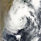
Cyclone Bijli was the first tropical cyclone to form during the 2009 North Indian Ocean cyclone season
. Cyclonic Storm Bijli formed from an area of Low Pressure on April 14. Later that evening, RSMC New Delhi upgraded the Low Pressure into a Deep Depression. Joint Typhoon Warning Center
issued a Tropical Cyclone Formation Alert
and designated Bijli as Tropical Depression 01B. While RSMC New Delhi designated it as Deep Depression, during the morning on April 15. Later that day, both RSMC New Delhi and Joint Typhoon Warning Center issued full warnings on Bijli as it intensifies to a Tropical storm. They also classified Bijli as a Tropical cyclone on that day. But on the morning of April 17, RSMC New Delhi downgraded cyclone Bijli into a deep depression Due to land interaction. However, on April 18, RSMC New Delhi continues to issue warnings on Bijli as it moves toward Northern Myanmar
(Burma). The word Bijli refers to lightning
in Hindi
.
became slightly organized over the central Bay of Bengal
. Later that day, an area of low pressure
developed underneath the convection as the system developed. Weak banding features
also formed around the periphery of the storm. By April 14, deep convection persisted around the center of circulation; following the development the RSMC in New Delhi, India designated the system as Depression BOB 01. Following further development, the Joint Typhoon Warning Center
(JTWC) issued a Tropical Cyclone Formation Alert
(TCFA) as they anticipated the system to develop into a tropical storm. Early the next morning the JTWC reported that the depression had intensified into a tropical storm and designated it as Cyclone 01B. The storm tracked towards the west-northwest due to a mid-level ridge
over India. Later that morning RSMC New Delhi reported that the depression had intensified into a deep depression and reported it was expected to intensify into Cyclonic Storm Bijli. Around 1500 UTC, the RSMC New Delhi upgraded the system to a cyclonic storm and gave it the name Bijli. Partial convective banding developed around the periphery of the system as it intensified. The conditions for good outflow
were present but did not develop. Around this time, the forward motion of the storm also slowed. On April 16, the storm turned towards the northeast, paralleling the eastern coast of India. Around 0600 UTC, RSMC New Delhi reported that Bijli had reached its peak intensity with winds of 75 km/h (45 mph 3-minute winds). Early on April 17, RSMC New Delhi reported that Bijli had weakened into a deep depression as it started to move the northeast.
were placed on high alert due to rough seas produced by the storm. A Local Cautionary Signal Number Three was issued for the Gopalpur, Puri, Paradeep and Chandabali
ports. Heavy rain from thunderstorms fell in coastal Andhra and Orissa due to the outer bands
of Bijli. Winds up to 55 km/h (35 mph) were also reported along the coast.
of 2.1 to 3 m (7 to 10 ft). On April 17, all flights in and out of Bangladesh were cancelled due to dangerous conditions. Shelters were also opened and were reportedly able to accommodate about one million people. In Chittagong
, 6,000 volunteers set up to assist in the aftermath of the storm and about 283 medical teams formed within the group. An estimated 200,000 people evacuated from Chittagong and the Cox's Bazar District
before the storm made landfall.
The Tropical Rainfall Measuring Mission
satellite, jointly operated by NASA
and JAXA, estimated that Bijli produced a maximum of 129 mm (5.07 in) of rain over coastal Bangladesh, with rainfall rates reaching nearly 50 mm/h (2 in/h). High winds downed several trees; numerous homes sustained damage and several ships on offshore islands were reportedly caught in the storm. High winds and heavy rains have also knocked out power to some communities. A storm surge of 2.1 m (7 ft) was recorded in the Cox's Bazar District with reports higher amounts in localized areas. At least 12 huts, 50 betel beef fields, and a large amount of salt have been damaged by the storm. Later reports indicated that thousands of homes have been damaged or destroyed by the storm. The first fatality caused by Bijli occurred when a tree knocked down by high winds fell on a 9-year-old boy, killing him on impact and injuring his sister. In the Cox's Bazar District, a school teacher and two students were killed. One of the two children was trampled to death during the evacuation. The other child was killed when his home collapsed on top of him.
During the evacuation, a 48-year-old man collapsed and died after suffering a heart attack. His child, who was only a few months old, also died from medical circumstances which were aggravated during the evacuation. In all, the storm destroyed 500 thatched houses and 1,500 betel leaf plantations and flooded about 70000 acres (283.3 km²) of cropland. Throughout Bangladesh, seven people were killed and 84 were injured. A total of 702 homes were destroyed and more than 3,825 others were damaged as well as 3636 acres (14.7 km²) of agricultural land. In the Cox's Bazar District, 607 heads of cattle drowned during the storm. Following the impacts of Bijli, the Government of Bangladesh allocated Tk.
79,000 (US$1,147) in assistance to affected population. The Department of Relief and Rehabilitation in Bangladesh provided 450 metric tonnes of rice to four districts, 200 of which was sent to Chittagong. To prevent an outbreak of post-storm diseases, the World Health Organization
deployed 1,105 medical teams to the country.
almost a year prior, officials in Myanmar urged residents along the coast to evacuate. Thousands of residents living in rural villages sought shelter in inland towns along the coast of Myanmar. The entire village of Aukpyunewa evacuated after hearing about an approaching cyclone on the radio. According to local residents, "We are taking precautions unlike earlier" in reference to the large loss of life due to Cyclone Nargis. The storm produced little or no storm surge in Myanmar as it made landfall; however, the remnants of Bijli produced heavy rains over northern areas of the country before the storm dissipated.
2009 North Indian Ocean cyclone season
The 2009 North Indian Ocean cyclone season was an event in the annual cycle of tropical cyclone formation. The North Indian Ocean cyclone season has no official bounds, but cyclones tend to form between April and December, with peaks in May and November...
. Cyclonic Storm Bijli formed from an area of Low Pressure on April 14. Later that evening, RSMC New Delhi upgraded the Low Pressure into a Deep Depression. Joint Typhoon Warning Center
Joint Typhoon Warning Center
The Joint Typhoon Warning Center is a joint United States Navy – United States Air Force task force located at the Naval Maritime Forecast Center in Pearl Harbor, Hawaii...
issued a Tropical Cyclone Formation Alert
Tropical Cyclone Formation Alert
A Tropical Cyclone Formation Alert is a bulletin released by the U.S. Navy-operated Joint Typhoon Warning Center in Honolulu, Hawaii or the Naval Maritime Forecast Center in Norfolk, Virginia, warning of the possibility of a tropical cyclone forming from a tropical disturbance that has been...
and designated Bijli as Tropical Depression 01B. While RSMC New Delhi designated it as Deep Depression, during the morning on April 15. Later that day, both RSMC New Delhi and Joint Typhoon Warning Center issued full warnings on Bijli as it intensifies to a Tropical storm. They also classified Bijli as a Tropical cyclone on that day. But on the morning of April 17, RSMC New Delhi downgraded cyclone Bijli into a deep depression Due to land interaction. However, on April 18, RSMC New Delhi continues to issue warnings on Bijli as it moves toward Northern Myanmar
Myanmar
Burma , officially the Republic of the Union of Myanmar , is a country in Southeast Asia. Burma is bordered by China on the northeast, Laos on the east, Thailand on the southeast, Bangladesh on the west, India on the northwest, the Bay of Bengal to the southwest, and the Andaman Sea on the south....
(Burma). The word Bijli refers to lightning
Lightning
Lightning is an atmospheric electrostatic discharge accompanied by thunder, which typically occurs during thunderstorms, and sometimes during volcanic eruptions or dust storms...
in Hindi
Hindi
Standard Hindi, or more precisely Modern Standard Hindi, also known as Manak Hindi , High Hindi, Nagari Hindi, and Literary Hindi, is a standardized and sanskritized register of the Hindustani language derived from the Khariboli dialect of Delhi...
.
Meteorological history
On April 13, an area of shower and thunderstormsAtmospheric convection
Atmospheric convection is the result of a parcel-environment instability, or temperature difference, layer in the atmosphere. Different lapse rates within dry and moist air lead to instability. Mixing of air during the day which expands the height of the planetary boundary layer leads to...
became slightly organized over the central Bay of Bengal
Bay of Bengal
The Bay of Bengal , the largest bay in the world, forms the northeastern part of the Indian Ocean. It resembles a triangle in shape, and is bordered mostly by the Eastern Coast of India, southern coast of Bangladesh and Sri Lanka to the west and Burma and the Andaman and Nicobar Islands to the...
. Later that day, an area of low pressure
Low pressure area
A low-pressure area, or "low", is a region where the atmospheric pressure at sea level is below that of surrounding locations. Low-pressure systems form under areas of wind divergence which occur in upper levels of the troposphere. The formation process of a low-pressure area is known as...
developed underneath the convection as the system developed. Weak banding features
Rainband
A rainband is a cloud and precipitation structure associated with an area of rainfall which is significantly elongated. Rainbands can be stratiform or convective, and are generated by differences in temperature. When noted on weather radar imagery, this precipitation elongation is referred to as...
also formed around the periphery of the storm. By April 14, deep convection persisted around the center of circulation; following the development the RSMC in New Delhi, India designated the system as Depression BOB 01. Following further development, the Joint Typhoon Warning Center
Joint Typhoon Warning Center
The Joint Typhoon Warning Center is a joint United States Navy – United States Air Force task force located at the Naval Maritime Forecast Center in Pearl Harbor, Hawaii...
(JTWC) issued a Tropical Cyclone Formation Alert
Tropical Cyclone Formation Alert
A Tropical Cyclone Formation Alert is a bulletin released by the U.S. Navy-operated Joint Typhoon Warning Center in Honolulu, Hawaii or the Naval Maritime Forecast Center in Norfolk, Virginia, warning of the possibility of a tropical cyclone forming from a tropical disturbance that has been...
(TCFA) as they anticipated the system to develop into a tropical storm. Early the next morning the JTWC reported that the depression had intensified into a tropical storm and designated it as Cyclone 01B. The storm tracked towards the west-northwest due to a mid-level ridge
High pressure area
A high-pressure area is a region where the atmospheric pressure at the surface of the planet is greater than its surrounding environment. Winds within high-pressure areas flow outward due to the higher density air near their center and friction with land...
over India. Later that morning RSMC New Delhi reported that the depression had intensified into a deep depression and reported it was expected to intensify into Cyclonic Storm Bijli. Around 1500 UTC, the RSMC New Delhi upgraded the system to a cyclonic storm and gave it the name Bijli. Partial convective banding developed around the periphery of the system as it intensified. The conditions for good outflow
Outflow (meteorology)
Outflow, in meteorology, is air that flows outwards from a storm system. It is associated with ridging, or anticyclonic flow. In the low levels of the troposphere, outflow radiates from thunderstorms in the form of a wedge of rain-cooled air, which is visible as a thin rope-like cloud on weather...
were present but did not develop. Around this time, the forward motion of the storm also slowed. On April 16, the storm turned towards the northeast, paralleling the eastern coast of India. Around 0600 UTC, RSMC New Delhi reported that Bijli had reached its peak intensity with winds of 75 km/h (45 mph 3-minute winds). Early on April 17, RSMC New Delhi reported that Bijli had weakened into a deep depression as it started to move the northeast.
India
All four ports in OrissaOrissa
Orissa , officially Odisha since Nov 2011, is a state of India, located on the east coast of India, by the Bay of Bengal. It is the modern name of the ancient nation of Kalinga, which was invaded by the Maurya Emperor Ashoka in 261 BC. The modern state of Orissa was established on 1 April...
were placed on high alert due to rough seas produced by the storm. A Local Cautionary Signal Number Three was issued for the Gopalpur, Puri, Paradeep and Chandabali
Chandabali
Chandabali is a community in the Bhadrak district of Orissa on the bank of the River Baitarani, and a tourist destination for visitors to the Bhitarkanika Wildlife Sanctuary.-History:...
ports. Heavy rain from thunderstorms fell in coastal Andhra and Orissa due to the outer bands
Rainband
A rainband is a cloud and precipitation structure associated with an area of rainfall which is significantly elongated. Rainbands can be stratiform or convective, and are generated by differences in temperature. When noted on weather radar imagery, this precipitation elongation is referred to as...
of Bijli. Winds up to 55 km/h (35 mph) were also reported along the coast.
Bangladesh
In Bangladesh, at least 40,000 volunteers from the Bangladeshi Red Cross were placed on standby in case evacuations were required. Bangladeshi officials urged all ports to be on high alert and all fishermen to stay at port. The warning signal was placed at No. 3 on a scale of 1 to 10, with 10 being the highest level of warning. Thousands of residents on Moheshkhali Island evacuated to 80 shelters. As the storm neared landfall, ports in Chittagong raised their warning level to seven. Following the increased warning level, an estimated 10,000 evacuated from coastal regions. Weather officials estimated that the storm would produce a storm surgeStorm surge
A storm surge is an offshore rise of water associated with a low pressure weather system, typically tropical cyclones and strong extratropical cyclones. Storm surges are caused primarily by high winds pushing on the ocean's surface. The wind causes the water to pile up higher than the ordinary sea...
of 2.1 to 3 m (7 to 10 ft). On April 17, all flights in and out of Bangladesh were cancelled due to dangerous conditions. Shelters were also opened and were reportedly able to accommodate about one million people. In Chittagong
Chittagong
Chittagong ) is a city in southeastern Bangladesh and the capital of an eponymous district and division. Built on the banks of the Karnaphuli River, the city is home to Bangladesh's busiest seaport and has a population of over 4.5 million, making it the second largest city in the country.A trading...
, 6,000 volunteers set up to assist in the aftermath of the storm and about 283 medical teams formed within the group. An estimated 200,000 people evacuated from Chittagong and the Cox's Bazar District
Cox's Bazar District
Cox's Bazar District is a district in the Chittagong Division of Bangladesh. It is named after Cox's Bazar, which is one of the world's longest natural sea beaches . It is located south of Chittagong. Cox's Bazar is also known by the name Panowa . Another old name was Palongkee...
before the storm made landfall.
The Tropical Rainfall Measuring Mission
Tropical Rainfall Measuring Mission
The Tropical Rainfall Measuring Mission is a joint space mission between NASA and the Japan Aerospace Exploration Agency designed to monitor and study tropical rainfall. The term refers to both the mission itself and the satellite that the mission uses to collect data...
satellite, jointly operated by NASA
NASA
The National Aeronautics and Space Administration is the agency of the United States government that is responsible for the nation's civilian space program and for aeronautics and aerospace research...
and JAXA, estimated that Bijli produced a maximum of 129 mm (5.07 in) of rain over coastal Bangladesh, with rainfall rates reaching nearly 50 mm/h (2 in/h). High winds downed several trees; numerous homes sustained damage and several ships on offshore islands were reportedly caught in the storm. High winds and heavy rains have also knocked out power to some communities. A storm surge of 2.1 m (7 ft) was recorded in the Cox's Bazar District with reports higher amounts in localized areas. At least 12 huts, 50 betel beef fields, and a large amount of salt have been damaged by the storm. Later reports indicated that thousands of homes have been damaged or destroyed by the storm. The first fatality caused by Bijli occurred when a tree knocked down by high winds fell on a 9-year-old boy, killing him on impact and injuring his sister. In the Cox's Bazar District, a school teacher and two students were killed. One of the two children was trampled to death during the evacuation. The other child was killed when his home collapsed on top of him.
During the evacuation, a 48-year-old man collapsed and died after suffering a heart attack. His child, who was only a few months old, also died from medical circumstances which were aggravated during the evacuation. In all, the storm destroyed 500 thatched houses and 1,500 betel leaf plantations and flooded about 70000 acres (283.3 km²) of cropland. Throughout Bangladesh, seven people were killed and 84 were injured. A total of 702 homes were destroyed and more than 3,825 others were damaged as well as 3636 acres (14.7 km²) of agricultural land. In the Cox's Bazar District, 607 heads of cattle drowned during the storm. Following the impacts of Bijli, the Government of Bangladesh allocated Tk.
Bangladeshi taka
The Taka is the currency of Bangladesh. Bangladesh Bank, the central bank of the country controls the issuance of the currency except one taka and two taka notes, which are the responsibility of Ministry of Finance of the government of Bangladesh...
79,000 (US$1,147) in assistance to affected population. The Department of Relief and Rehabilitation in Bangladesh provided 450 metric tonnes of rice to four districts, 200 of which was sent to Chittagong. To prevent an outbreak of post-storm diseases, the World Health Organization
World Health Organization
The World Health Organization is a specialized agency of the United Nations that acts as a coordinating authority on international public health. Established on 7 April 1948, with headquarters in Geneva, Switzerland, the agency inherited the mandate and resources of its predecessor, the Health...
deployed 1,105 medical teams to the country.
Myanmar
A storm surge of 1.8 to 2.4 m (6 to 8 ft) was also expected to impact coastal areas of Myanmar close to the Bangladeshi border. An estimated 6,000 fishing trawlers were to return to port by the afternoon of April 17. Following the devastating results of Cyclone NargisCyclone Nargis
Cyclone Nargis , was a strong tropical cyclone that caused the worst natural disaster in the recorded history of Burma. The cyclone made landfall in Burma on Friday, May 2, 2008, causing catastrophic destruction and at least 138,000 fatalities...
almost a year prior, officials in Myanmar urged residents along the coast to evacuate. Thousands of residents living in rural villages sought shelter in inland towns along the coast of Myanmar. The entire village of Aukpyunewa evacuated after hearing about an approaching cyclone on the radio. According to local residents, "We are taking precautions unlike earlier" in reference to the large loss of life due to Cyclone Nargis. The storm produced little or no storm surge in Myanmar as it made landfall; however, the remnants of Bijli produced heavy rains over northern areas of the country before the storm dissipated.