

Cumberland (Atlanta)
Encyclopedia
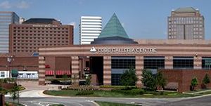
Cumberland is a neighborhood and edge city
in metro Atlanta, Georgia, United States. with approximately 122,000 workers and 103,000 residents. It is a major hub for business, convention, and retail in the region. Cumberland is situated ten miles (16 km) northwest of downtown Atlanta
at the junction of I-75 and I-285 (the "Cobb Cloverleaf
") in Cobb County. The area is marked by several modern skyscrapers
rising from the wooded hills above the freeways. These towers house some of the area's 24 million square feet (over 2.2 million square meters) of office space, containing more office space than downtown Miami
and making it metro Atlanta
's fifth-largest commercial office district, after Downtown, Midtown
, Buckhead
, and Perimeter Center
. Heavyweights such as Home Depot, and The Weather Channel are headquartered in Cumberland. It also houses some ten million square feet (930,000m²) of retail, with its focal point being the newly-renovated Cumberland Mall
. Although small portions of Cumberland lay within Smyrna
and Vinings
, the majority of the area remains unincorporated with an Atlanta address.
reservation which still has a road bearing its name in the Vinings vicinity. Cumberland began most of its growth following World War II
, but went into overdrive when Cumberland Mall opened as Georgia's largest mall and metro Atlanta's sixth enclosed, regional mall in 1973. A decade later, the first office tower of the Galleria was built on 86 acres (348,030 m²) of prime space in what became the heart of the Cumberland district. This paved the way for several other towers, retail strip
s and hotel
s. In 1988 property owners formed the Cumberland Community Improvement District (Cumberland CID), the first in Georgia. The CID, a self-taxing district, has raised millions and has completed several infrastructure
improvements in the area since its inception. During the summer of 1994, the Cobb-Marietta Exhibit Hall and Coliseum Authority built the $48 million Cobb Galleria
Centre by renovating the existing mall there, and it has become another success for the district.
A few small shopping centers were constructed in the mid-1990s, and a Cumberland Mall
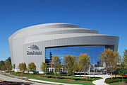
expansion and renovation was completed in 2006. Construction was completed on the Cobb Energy Performing Arts Centre
in late 2007, adding nightlife
to the area. The Atlanta Opera, founded in 1979, has moved its base to this location.
 There are many private projects in progress and/or proposed, including:
Most of the above plans have a public parking garage aspect included.
There are also planned public projects:

, the district's main street
. Windy Hill Road is generally the northern extent of the district, except possibly for Terrell Mill Road. To the south and west, it extends down Cumberland Parkway and Paces Ferry roads.
Cumberland Boulevard encircles most of the area, and then continues northeast to Wildwood as Windy Ridge Parkway after crossing 41. Windy Ridge runs through the Interstate North office park, located immediately to the north of the interchange, and home to the Weather Channel. Interstate North Parkway runs parallel to 75 southeast to 285, then parallels it (and Powers Ferry) across the Chattahoochee River
. Akers Mill Road starts in the east at Powers Ferry, is broken by a stretch of Cumberland Boulevard, then continues west across 41. Circle 75 Parkway begins at Windy Hill Road, opposite the I-75 southbound off-ramp, and parallels the road until turning southwest along I-285, becoming Spring Road at 41 (and then Concord Road at Atlanta Road in Smyrna).
The Cumberland district also borders the West Paces Ferry district of Buckhead
in Atlanta and a portion of Sandy Springs, separated by the Chattahoochee River
.
Notably, one of metro Atlanta's worst tornadoes
made its first touchdown in the area, at Windy Hill Road and Cobb Parkway in April 1998. The Dunwoody tornado, as it came to be known for its major damage in Dunwoody, was captured on police video and later shown around the world as the two Cobb County Police officers drove southbound on 41 right through it, in order to escape the nighttime surprise.
Just a few miles or several kilometers east on the Perimeter at Georgia 400 and the boundary between Dunwoody and Sandy Springs is Perimeter Center
, another similar edge city also created as a result of the Interstate Highway System
and GDOT's choice of highway location in the 1960s. The Cumberland skyline
can be easily seen in front of Atlanta's by looking southeast from atop Kennesaw Mountain
.
Edge city
"Edge city" is an American term for a concentration of business, shopping, and entertainment outside a traditional urban area in what had recently been a residential suburb or semi-rural community...
in metro Atlanta, Georgia, United States. with approximately 122,000 workers and 103,000 residents. It is a major hub for business, convention, and retail in the region. Cumberland is situated ten miles (16 km) northwest of downtown Atlanta
Downtown Atlanta
Downtown Atlanta is the first and largest of the three financial districts in the city of Atlanta. Downtown Atlanta is the location of many corporate or regional headquarters, city, county, state and federal government facilities, sporting facilities, and is the central tourist attraction of the city...
at the junction of I-75 and I-285 (the "Cobb Cloverleaf
Cobb Cloverleaf
The Cobb Cloverleaf is the name given to the interchange between Interstate 75 , Interstate 285 , U.S. Route 41 and Georgia State Route 3 in Cobb County, Georgia, northwest of Atlanta. Despite the name, the interchange has only two cloverleaf-style ramps...
") in Cobb County. The area is marked by several modern skyscrapers
Skyscraper
A skyscraper is a tall, continuously habitable building of many stories, often designed for office and commercial use. There is no official definition or height above which a building may be classified as a skyscraper...
rising from the wooded hills above the freeways. These towers house some of the area's 24 million square feet (over 2.2 million square meters) of office space, containing more office space than downtown Miami
Downtown Miami
Downtown Miami is an urban residential neighborhood, and the central business district of Miami, Miami-Dade County, and South Florida in the United States...
and making it metro Atlanta
Metro Atlanta
The Atlanta metropolitan area or metro Atlanta, officially designated by the US Census Bureau as the Atlanta-Sandy Springs-Marietta Metropolitan Statistical Area, is the most populous metro area in the U.S. state of Georgia and the ninth-largest metropolitan statistical area in the United States...
's fifth-largest commercial office district, after Downtown, Midtown
Midtown Atlanta
Midtown is the second largest financial district in the city of Atlanta, Georgia, situated between the commercial and financial districts of Downtown and SoNo to the south and the affluent residential and commercial district of Buckhead to the north...
, Buckhead
Buckhead (Atlanta)
Buckhead is the uptown district of Atlanta, Georgia, United States, comprising approximately the northern one-fifth of the city. Buckhead is a major commercial and financial center of the Southeast, and it is the third-largest business district in Atlanta, behind Downtown and Midtown...
, and Perimeter Center
Perimeter Center
Perimeter Center is a neighborhood and major edge city in metro Atlanta, Georgia, United States. It is centered on Perimeter Mall, the nucleus around which it has formed. Perimeter Center is located north-northeast of Atlanta proper, and lies within two cities - Dunwoody and Sandy Springs...
. Heavyweights such as Home Depot, and The Weather Channel are headquartered in Cumberland. It also houses some ten million square feet (930,000m²) of retail, with its focal point being the newly-renovated Cumberland Mall
Cumberland Mall
Cumberland Mall, located in the Cumberland district of Metropolitan Atlanta near the suburbs of Smyrna and Vinings, opened on August 8, 1973 and was the largest mall in Georgia, United States, when it first opened.-Early years:...
. Although small portions of Cumberland lay within Smyrna
Smyrna, Georgia
-Demographics:As of the census of 2000, there were 40,999 people, 18,372 households, and 9,498 families residing in the city. The population density was 2,949.9 people per square mile . There were 19,633 housing units at an average density of 1,412.6 per square mile...
and Vinings
Vinings, Georgia
Vinings is a census-designated place and an unincorporated town in Cobb County, Georgia, just across the Chattahoochee River from Atlanta. As of the 2010 census, the town had a total population of 9,734. It is located between the affluent West Paces Ferry section of Buckhead in northwest Atlanta,...
, the majority of the area remains unincorporated with an Atlanta address.
History
Cumberland has changed immensely over the past 50 years. In 1960, the area contained Camp Bert Adams, a Boy ScoutBoy Scout
A Scout is a boy or a girl, usually 11 to 18 years of age, participating in the worldwide Scouting movement. Because of the large age and development span, many Scouting associations have split this age group into a junior and a senior section...
reservation which still has a road bearing its name in the Vinings vicinity. Cumberland began most of its growth following World War II
World War II
World War II, or the Second World War , was a global conflict lasting from 1939 to 1945, involving most of the world's nations—including all of the great powers—eventually forming two opposing military alliances: the Allies and the Axis...
, but went into overdrive when Cumberland Mall opened as Georgia's largest mall and metro Atlanta's sixth enclosed, regional mall in 1973. A decade later, the first office tower of the Galleria was built on 86 acres (348,030 m²) of prime space in what became the heart of the Cumberland district. This paved the way for several other towers, retail strip
Strip mall
A strip mall is an open-area shopping center where the stores are arranged in a row, with a sidewalk in front. Strip malls are typically developed as a unit and have large parking lots in front...
s and hotel
Hotel
A hotel is an establishment that provides paid lodging on a short-term basis. The provision of basic accommodation, in times past, consisting only of a room with a bed, a cupboard, a small table and a washstand has largely been replaced by rooms with modern facilities, including en-suite bathrooms...
s. In 1988 property owners formed the Cumberland Community Improvement District (Cumberland CID), the first in Georgia. The CID, a self-taxing district, has raised millions and has completed several infrastructure
Infrastructure
Infrastructure is basic physical and organizational structures needed for the operation of a society or enterprise, or the services and facilities necessary for an economy to function...
improvements in the area since its inception. During the summer of 1994, the Cobb-Marietta Exhibit Hall and Coliseum Authority built the $48 million Cobb Galleria
Cobb Galleria
Cobb Galleria is a large office park with six skyscrapers located in the Cumberland/Vinings district of Cobb in the U.S. state of Georgia and sandwiched between Marietta, Smyrna, Sandy Springs, and Atlanta...
Centre by renovating the existing mall there, and it has become another success for the district.
A few small shopping centers were constructed in the mid-1990s, and a Cumberland Mall
Cumberland Mall
Cumberland Mall, located in the Cumberland district of Metropolitan Atlanta near the suburbs of Smyrna and Vinings, opened on August 8, 1973 and was the largest mall in Georgia, United States, when it first opened.-Early years:...
expansion and renovation was completed in 2006. Construction was completed on the Cobb Energy Performing Arts Centre
Cobb Energy Performing Arts Centre
The Cobb Energy Performing Arts Centre is a performing arts venue located in the Cumberland/Galleria edge city, just northwest of Atlanta, Georgia...
in late 2007, adding nightlife
Nightlife
Nightlife is the collective term for any entertainment that is available and more popular from the late evening into the early hours of the morning...
to the area. The Atlanta Opera, founded in 1979, has moved its base to this location.
Future
- Riverwood 200: At the corner of Cumberland Blvd and Cobb Parkway. 360 residential units and also a large amount of office and retail space including a 16 story office tower as an extension of the already existing Riverwood 100 complex. Ground has already broken on Riverwood. The project is led by Seven Oaks Company LLC and GE Asset Management. Architect is HOK.
- Park Vinings: Originally planned to be 110 $1 million + condo units, recent zoning submissions indicates that the change in the housing market and the currently saturated condo market in Atlanta has resulted in plans being changed for this property to house a 33 story retirement community with increased density than the original plans. http://www.ajc.com/metro/content/metro/cobb/stories/2009/02/17/cobb_retirement_skyscraper.html http://zoning.comdev.cobbcountyga.gov/2009-02/final_zoning_analysis/Z-006-2009.pdf http://www.parksignature.com/high-rise-communities/properties.cfm?key=Park-Vinings http://smyrnablog.com/?p=194.
- Akers Mill Square redevelopment and refacing http://www.ajc.com/metro/content/metro/cobb/stories/2007/09/13/cobbdev_0914.html
- Two mid-rise towers overlooking I-75 by Grove Street Partners LLC just south of the Cobb Energy Performing Arts CentreCobb Energy Performing Arts CentreThe Cobb Energy Performing Arts Centre is a performing arts venue located in the Cumberland/Galleria edge city, just northwest of Atlanta, Georgia...
. One 18 and one 15 floor tower are approved by Cobb County. http://atlanta.bizjournals.com/atlanta/stories/2007/09/17/focus21.html - Phase 2 of Overton Park owned by Hines Interests and being developed by Madison Retail LLC to add 60 condominium units and retail shops http://www.hines.com/property/detail.aspx?id=141
- Galleria: Day Capital Partners purchased 3 acres (12,140.6 m²) for $8.7 million directly adjoining the Cobb GalleriaCobb GalleriaCobb Galleria is a large office park with six skyscrapers located in the Cumberland/Vinings district of Cobb in the U.S. state of Georgia and sandwiched between Marietta, Smyrna, Sandy Springs, and Atlanta...
for future projects after 2010 when the current land lease runs out for the stores located on that property. The projects will likely include mixed retail/residential. http://www.allbusiness.com/operations/facilities-commercial-real-estate/4417549-1.html - Crescent Ridge: 20-story office building and plaza on Cumberland Blvd next to the highway http://www.costar.com/FreeSearch/Detail/Detail.aspx?p=4AB65AEC363AFEF629CAEA9868B159BC http://www.crescent-resources.com/commer/atlanta/crescentridge/siteplan.asp
- 2555 Cumberland: Two eight story office buildings overlooking 285 by the Shailendra Group. http://www.shailendragroup.com/pdf/cumberland_mall.pdf
Most of the above plans have a public parking garage aspect included.
There are also planned public projects:
- Various "streetscapes" projects to improve the aesthetic appearance of streets, sidewalks and intersections including the installation of upscale lighting. http://www.cobbgalleria.com/newsletter/summer2006/index.htmlhttp://www.bizjournals.com/atlanta/stories/2006/12/18/focus6.html
- Adding a I-75 North to 285 flyover. http://www.revive285.com/
- Cobb transit station at Akers mill for either bus rapid transit or light rail. http://www.cobbrealestateblog.com/2006/11/116 http://www.revive285.com/
- There is a planned Aker's Mill Trail that will connect to the Silver Comet TrailSilver Comet TrailThe Silver Comet Trail is a paved, multi-use, recreational trail in western Georgia.-Route:The Silver Comet Trail is a rail trail and is named for the Silver Comet passenger train that used the same route from 1947 to 1969...
and the Chattahoochee River Trail. http://dot.cobbcountyga.gov/cobb-trails.htm
Geography
While there are no official boundaries (except for the CID, which is a 5 ½-square-mile area that includes the intersections of I-75, I-285 and U.S. Highway 41), the business district generally extends as far northeast as the Wildwood Office Park on Powers Ferry Road, and up Cobb ParkwayCobb Parkway
Cobb Parkway is a major arterial road which runs northwest and southeast through Cobb County, Georgia. It concurrently carries both U.S. 41, and the much less-recognized Georgia 3...
, the district's main street
Main Street
Main Street is the metonym for a generic street name of the primary retail street of a village, town, or small city in many parts of the world...
. Windy Hill Road is generally the northern extent of the district, except possibly for Terrell Mill Road. To the south and west, it extends down Cumberland Parkway and Paces Ferry roads.
Cumberland Boulevard encircles most of the area, and then continues northeast to Wildwood as Windy Ridge Parkway after crossing 41. Windy Ridge runs through the Interstate North office park, located immediately to the north of the interchange, and home to the Weather Channel. Interstate North Parkway runs parallel to 75 southeast to 285, then parallels it (and Powers Ferry) across the Chattahoochee River
Chattahoochee River
The Chattahoochee River flows through or along the borders of the U.S. states of Georgia, Alabama, and Florida. It is a tributary of the Apalachicola River, a relatively short river formed by the confluence of the Chattahoochee and Flint Rivers and emptying into Apalachicola Bay in the Gulf of...
. Akers Mill Road starts in the east at Powers Ferry, is broken by a stretch of Cumberland Boulevard, then continues west across 41. Circle 75 Parkway begins at Windy Hill Road, opposite the I-75 southbound off-ramp, and parallels the road until turning southwest along I-285, becoming Spring Road at 41 (and then Concord Road at Atlanta Road in Smyrna).
The Cumberland district also borders the West Paces Ferry district of Buckhead
Buckhead (Atlanta)
Buckhead is the uptown district of Atlanta, Georgia, United States, comprising approximately the northern one-fifth of the city. Buckhead is a major commercial and financial center of the Southeast, and it is the third-largest business district in Atlanta, behind Downtown and Midtown...
in Atlanta and a portion of Sandy Springs, separated by the Chattahoochee River
Chattahoochee River
The Chattahoochee River flows through or along the borders of the U.S. states of Georgia, Alabama, and Florida. It is a tributary of the Apalachicola River, a relatively short river formed by the confluence of the Chattahoochee and Flint Rivers and emptying into Apalachicola Bay in the Gulf of...
.
Notably, one of metro Atlanta's worst tornadoes
Tornado
A tornado is a violent, dangerous, rotating column of air that is in contact with both the surface of the earth and a cumulonimbus cloud or, in rare cases, the base of a cumulus cloud. They are often referred to as a twister or a cyclone, although the word cyclone is used in meteorology in a wider...
made its first touchdown in the area, at Windy Hill Road and Cobb Parkway in April 1998. The Dunwoody tornado, as it came to be known for its major damage in Dunwoody, was captured on police video and later shown around the world as the two Cobb County Police officers drove southbound on 41 right through it, in order to escape the nighttime surprise.
Just a few miles or several kilometers east on the Perimeter at Georgia 400 and the boundary between Dunwoody and Sandy Springs is Perimeter Center
Perimeter Center
Perimeter Center is a neighborhood and major edge city in metro Atlanta, Georgia, United States. It is centered on Perimeter Mall, the nucleus around which it has formed. Perimeter Center is located north-northeast of Atlanta proper, and lies within two cities - Dunwoody and Sandy Springs...
, another similar edge city also created as a result of the Interstate Highway System
Interstate Highway System
The Dwight D. Eisenhower National System of Interstate and Defense Highways, , is a network of limited-access roads including freeways, highways, and expressways forming part of the National Highway System of the United States of America...
and GDOT's choice of highway location in the 1960s. The Cumberland skyline
Skyline
A skyline is the overall or partial view of a city's tall buildings and structures consisting of many skyscrapers in front of the sky in the background. It can also be described as the artificial horizon that a city's overall structure creates. Skylines serve as a kind of fingerprint of a city, as...
can be easily seen in front of Atlanta's by looking southeast from atop Kennesaw Mountain
Kennesaw Mountain
Kennesaw Mountain is a high-running ridge between Marietta and Kennesaw, Georgia in the United States with a summit elevation of . It is the highest point in the core metro Atlanta area, and fifth after further-north exurban counties are considered...
.
Attractions
- Cumberland MallCumberland MallCumberland Mall, located in the Cumberland district of Metropolitan Atlanta near the suburbs of Smyrna and Vinings, opened on August 8, 1973 and was the largest mall in Georgia, United States, when it first opened.-Early years:...
- Cobb Galleria CentreCobb Galleria CentreThe Cobb Galleria Centre is a meeting and convention center and a shopping center in the Cumberland/Galleria district of Cobb County, in northwest Atlanta, Georgia, in the United States. It is also located next to a cluster of mid-rise office buildings, the Cumberland Mall and the Cobb Energy...
- Cobb Energy Performing Arts CentreCobb Energy Performing Arts CentreThe Cobb Energy Performing Arts Centre is a performing arts venue located in the Cumberland/Galleria edge city, just northwest of Atlanta, Georgia...
- Chattahoochee River National Recreation AreaChattahoochee River National Recreation AreaChattahoochee River National Recreation Area preserves a series of sites between Atlanta in the United States and Lake Sidney Lanier along the Chattahoochee River. The 48-mile stretch of the river affords public recreation opportunities and access to historic spots...
- Silver Comet TrailSilver Comet TrailThe Silver Comet Trail is a paved, multi-use, recreational trail in western Georgia.-Route:The Silver Comet Trail is a rail trail and is named for the Silver Comet passenger train that used the same route from 1947 to 1969...