
Conival
Encyclopedia
Scotland
Scotland is a country that is part of the United Kingdom. Occupying the northern third of the island of Great Britain, it shares a border with England to the south and is bounded by the North Sea to the east, the Atlantic Ocean to the north and west, and the North Channel and Irish Sea to the...
mountain situated in Assynt
Assynt
Assynt is a civil parish in west Sutherland, Highland, Scotland – north of Ullapool.It is famous for its landscape and its remarkable mountains...
in the Sutherland
Sutherland
Sutherland is a registration county, lieutenancy area and historic administrative county of Scotland. It is now within the Highland local government area. In Gaelic the area is referred to according to its traditional areas: Dùthaich 'IcAoidh , Asainte , and Cataibh...
area of the Highland
Highland (council area)
Highland is a council area in the Scottish Highlands and is the largest local government area in both Scotland and the United Kingdom as a whole. It shares borders with the council areas of Moray, Aberdeenshire, Perth and Kinross, and Argyll and Bute. Their councils, and those of Angus and...
Council Area, 30 kilometres north-northeast of the town of Ullapool
Ullapool
Ullapool is a small town of around 1,300 inhabitants in Ross and Cromarty, Highland, Scotland. Despite its small size, it is the largest settlement for many miles around, and is a major tourist destination of Scotland. The North Atlantic Drift passes by Ullapool, bringing moderate temperatures...
.
Overview
Conival is a distinct landmark when viewed from the A837 road to the west from where its conspicuous 600 metres high western face is well seen, this flank is made up of light coloured and distinctive CambrianCambrian
The Cambrian is the first geological period of the Paleozoic Era, lasting from Mya ; it is succeeded by the Ordovician. Its subdivisions, and indeed its base, are somewhat in flux. The period was established by Adam Sedgwick, who named it after Cambria, the Latin name for Wales, where Britain's...
quartzite
Quartzite
Quartzite is a hard metamorphic rock which was originally sandstone. Sandstone is converted into quartzite through heating and pressure usually related to tectonic compression within orogenic belts. Pure quartzite is usually white to gray, though quartzites often occur in various shades of pink...
rock thickened by geological thrusting. The mountain reaches a height of 987 metres (3238 feet) and is classified as a Munro
Munro
A Munro is a mountain in Scotland with a height over . They are named after Sir Hugh Munro, 4th Baronet , who produced the first list of such hills, known as Munros Tables, in 1891. A Munro top is a summit over 3,000 ft which is not regarded as a separate mountain...
. It is connected to the adjoining and better known Munro of Ben More Assynt
Ben More Assynt
Ben More Assynt is a mountain in Assynt in the far north-west of Scotland, north-north-east of the town of Ullapool...
which lies 1.5 kilometres to the east by a high, rough quartzite ridge. Conival has a rich diversity of attractions on its slopes making it popular not just with walkers but also geologists
Geology
Geology is the science comprising the study of solid Earth, the rocks of which it is composed, and the processes by which it evolves. Geology gives insight into the history of the Earth, as it provides the primary evidence for plate tectonics, the evolutionary history of life, and past climates...
, biologists
Biology
Biology is a natural science concerned with the study of life and living organisms, including their structure, function, growth, origin, evolution, distribution, and taxonomy. Biology is a vast subject containing many subdivisions, topics, and disciplines...
and speleologists
Speleology
Speleology is the scientific study of caves and other karst features, their make-up, structure, physical properties, history, life forms, and the processes by which they form and change over time...
.
The mountain's name is slightly enigmatic in its meaning. The name does not originate from the Norse language like many of the hills in the Assynt area; it does in fact derive from Gaelic
Scottish Gaelic language
Scottish Gaelic is a Celtic language native to Scotland. A member of the Goidelic branch of the Celtic languages, Scottish Gaelic, like Modern Irish and Manx, developed out of Middle Irish, and thus descends ultimately from Primitive Irish....
. It was initially called Conamheall in the original Munros list of 1891, which translates as “adjoining hill” or “hill of meeting” (a reduced form of Gaelic coinneamh "meeting", and in prepositional constructions "opposite, facing", plus meall "round hill") which is probably the correct translation as it describes its close connection to Ben More Assynt. Between 1921 and 1969 the mountain was called Cona-mheall which translates as “enchanted hill”. Since 1974 it has been called by its anglicised name of Conival.
Geography and Geology
Conival is part of the Ben More Assynt Site of Special Scientific InterestSite of Special Scientific Interest
A Site of Special Scientific Interest is a conservation designation denoting a protected area in the United Kingdom. SSSIs are the basic building block of site-based nature conservation legislation and most other legal nature/geological conservation designations in Great Britain are based upon...
because of its outstanding geological features, it displays the Moine Thrust Belt
Moine Thrust Belt
The Moine Thrust Belt is a linear geological feature in the Scottish Highlands which runs from Loch Eriboll on the north coast 190 km south-west to the Sleat peninsula on the Isle of Skye...
clearly on its slopes, this is an upthrust of rocks caused by tectonic plate
Plate tectonics
Plate tectonics is a scientific theory that describes the large scale motions of Earth's lithosphere...
collision during the Silurian
Silurian
The Silurian is a geologic period and system that extends from the end of the Ordovician Period, about 443.7 ± 1.5 Mya , to the beginning of the Devonian Period, about 416.0 ± 2.8 Mya . As with other geologic periods, the rock beds that define the period's start and end are well identified, but the...
period. There are good examples of limestone
Limestone
Limestone is a sedimentary rock composed largely of the minerals calcite and aragonite, which are different crystal forms of calcium carbonate . Many limestones are composed from skeletal fragments of marine organisms such as coral or foraminifera....
pavement on the lower western flank of the mountain in the valley of the River Traligill. Conival also lies within the UNESCO endorsed North West Highlands Geopark and the Inchnadamph National Nature Reserve. The underlying limestone within the reserve creates ideal conditions for rare plants like mountain avens
Dryas octopetala
Dryas octopetala is an arctic-alpine flowering plant in the family Rosaceae. It is a small prostrate evergreen subshrub forming large colonies, and is a popular flower in rock gardens...
, frog orchid
Frog Orchid
The Frog Orchid, or Coeloglossum viride, also known as the Long-Bracted Green Orchid and Dactylorhiza viridis is a monotypic genus of the family Orchidaceae generally found within the palearctic ecozone throughout the mid to northern United States through Canada, and in the British Isles and parts...
and holly fern
Polystichum lonchitis
Polystichum lonchitis is a species of fern known by the common name northern holly fern, or simply holly fern. It is native to much of the Northern Hemisphere from Eurasia to Alaska to Greenland and south into mountainous central North America. It grows in moist, shady, rocky mountain habitat. This...
.
Conival consists of a main ridge which runs on an axis from north west to south east. The NW ridge connects to the subsidiary summit of Beinn an Fhurain with its highest point known as Na Tuadhan (852 metres). Na Tuadhan is an important geological area displaying spectacular folds of Cambrian quartzites exposed by the Moine Thrust on its southern cliffs above Coire a' Mhadaidh. The SSE ridge descends to Glen Oykel and this also displays “fantastic geology”. A spur runs south west off the SSE ridge to cross a col
Mountain pass
A mountain pass is a route through a mountain range or over a ridge. If following the lowest possible route, a pass is locally the highest point on that route...
(Bealach Traligill) that connect to the neighbouring Corbett of Breabag. A third ridge goes east to connect to Ben More Assynt, this ridge is rough underfoot with quartzite boulders and the traverse between the two Munros takes more time than expected even though there is a drop and re-ascent of only 113 metres.
Conival lies on the main east-west watershed of Scotland with drainage from its slopes reaching both coasts. The southern slopes are drained by the River Oykel
River Oykel
The River Oykel is a major river in northern Scotland that is famous for its salmon fishing. It rises on Ben More Assynt, a few miles from Ullapool on the west coast of Scotland, and drains into the North Sea via the Kyle of Sutherland...
which flows to the Dornoch Firth
Dornoch Firth
The Dornoch Firth is a firth on the east coast of Highland, in northern Scotland. It forms part of the boundary between Ross and Cromarty, to the south, and Sutherland, to the north....
on the eastern coast. Streams on the northern flanks also go east to the Dornoch Firth via Loch Shin
Loch Shin
Loch Shin is a loch in the Scottish North West Highlands. To the south is the small town of Lairg. The loch is the largest in Sutherland, runs from the north-west to the south-east and is 17 miles long....
while the western slopes are drained by the River Traligill which flows west through Loch Assynt
Loch Assynt
Loch Assynt is a freshwater loch in Sutherland, Scotland, 8 km ENE of Lochinver.Situated in a spectacular setting between the heights of Canisp, Quinag and Beinn Uidhe, it receives the outflow from Lochs Awe, Maol a' Choire, and Leitir Easaich. It discharges into the sea at Loch Inver, via the...
to find the sea at Lochinver
Lochinver
Lochinver is a village on the coast in the Assynt district of Sutherland, Highland, Scotland. A few miles northeast is Loch Assynt which is the source of the River Inver which flows into Loch Inver at the village. There are 200 or so lochans in the area which makes the place very popular with...
.
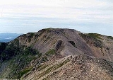
Ascents and the Summit
The usual route of ascent for Conival starts at Inchnadamph at grid reference where there is parking space near the Inchnadamph hotel. The route follows the valley of the River Traligill passing the Cnoc nan Uamh cave system located within a band of Cambrian limestone. These caves have a length of 1.4 kilometres and show the earliest traces of human habitation in Scotland from about 6,000 years BC. The route continues to the source of the river at the col between Beinn an Fhurain and Conival from where it is a rough climb up quartzite scree to the summit. Most walkers will continue on to Ben More Assynt, 1.5 km to the east.An alternative ascent for strong walkers is to tackle the entire ridge from north to south including the two Munros plus the Corbetts of Glas Bheinn in the north and Breabag to the south. The summit of Conival is a mass of disintegrating quartzite marked by a large circular wind shelter which has been built around the remains of an OS
Ordnance Survey
Ordnance Survey , an executive agency and non-ministerial government department of the Government of the United Kingdom, is the national mapping agency for Great Britain, producing maps of Great Britain , and one of the world's largest producers of maps.The name reflects its creation together with...
trig point
Trig point
A triangulation station, also known as a triangulation pillar, trigonometrical station, trigonometrical point, trig station, trig beacon or trig point, and sometimes informally as a trig, is a fixed surveying station, used in geodetic surveying and other surveying projects in its vicinity...
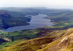
(all that remains is the base). The view from the top gives an impressive panorama to the west taking in the hills of Quinag
Quinag
The mountain Quinag in Sutherland, in the Scottish Highlands, is in fact a mountain range with an undulating series of peaks along its Y-shaped crest...
, Canisp
Canisp
Canisp is a mountain in the far north west of Scotland. It is situated in the parish of Assynt, in the county of Sutherland, 25 kilometres north of the town of Ullapool. Canisp reaches a height of 847 metres and qualifies as a Corbett and Marilyn hill...
and Cul Mor as well as an end on view of Loch Assynt (see photo).