

Community Displacement in Philadelphia
Encyclopedia
Mantua

Mantua, Philadelphia, Pennsylvania
Mantua is a neighborhood in the West Philadelphia section of Philadelphia, Pennsylvania. It is located north of Spring Garden Street, east of 40th Street, south of Mantua Avenue, and west of 31st Street...
is a neighborhood located in West Philadelphia
West Philadelphia
West Philadelphia, nicknamed West Philly, is a section of Philadelphia, Pennsylvania. Though there is no official definition of its boundaries, it is generally considered to reach from the western shore of the Schuylkill River, to City Line Avenue to the northwest, Cobbs Creek to the southwest, and...
. It lies north of Hamilton Street and south of Mantua Avenue, bounded to the west by 40th Street and to the east by 31st Street. Mantua
Mantua
Mantua is a city and comune in Lombardy, Italy and capital of the province of the same name. Mantua's historic power and influence under the Gonzaga family, made it one of the main artistic, cultural and notably musical hubs of Northern Italy and the country as a whole...
was originally an independent town, outside of Philadelphia city limits. The land was inherited by Judge William Peters, who planned it as a small development and marketed it as a settlement in 1809. In the late 1800s, Mantua became a predominantly white, working class neighborhood. In the 1940s, however, “white flight
White flight
White flight has been a term that originated in the United States, starting in the mid-20th century, and applied to the large-scale migration of whites of various European ancestries from racially mixed urban regions to more racially homogeneous suburban or exurban regions. It was first seen as...
” occurred due to many factors including redlining, deindustrialization, and suburbanization. As in many other areas of Philadelphia, "white flight
White flight
White flight has been a term that originated in the United States, starting in the mid-20th century, and applied to the large-scale migration of whites of various European ancestries from racially mixed urban regions to more racially homogeneous suburban or exurban regions. It was first seen as...
" resulted in Mantua becoming a primarily African American neighborhood.
Drexel University
Drexel University
Drexel University is a private research university with the main campus located in Philadelphia, Pennsylvania, USA. It was founded in 1891 by Anthony J. Drexel, a noted financier and philanthropist. Drexel offers 70 full-time undergraduate programs and accelerated degrees...
, which constructed its main building on 32nd and Chestnut Streets in 1889, has been the major institutional influence in Mantua for over a century. From 1910 to 1990, Drexel added many new buildings inside of Mantua. Many of these buildings were constructed on newly redeveloped lots, previously owned by residents of Mantua. When Drexel University released its 1970 Development Plan, residents of Powelton Village, a neighboring community, objected to the expansion, but to no avail. The purpose of the 1970 Development Plan was to "designate the additional amount of land" needed by Drexel University to support the expanding University's population and facility needs. Since the University of Pennsylvania owned most of the land to the west and the south, Drexel had to expand north into Mantua. The expansion of both Drexel and the University of Pennsylvania
University of Pennsylvania
The University of Pennsylvania is a private, Ivy League university located in Philadelphia, Pennsylvania, United States. Penn is the fourth-oldest institution of higher education in the United States,Penn is the fourth-oldest using the founding dates claimed by each institution...
has made the relatively inexpensive land inside of Mantua's boundaries very desirable. Today, much of the land continues to be redeveloped to accommodate the Drexel's needs, and recently many students have begun living in Mantua.
Currently, Mantua consists of low income residents (44% below poverty line), and 94% of the population is African American. Impoving Mantua has become a priority for city leaders, as the neighborhood has been plagued with violence and many blighted properties. In 2008, the Mantua Tower, a public housing project, was demolished. The Tower will be replaced with low density public housing. City officials view blight removal, beautification, and economic advancement as essential to future of Mantua
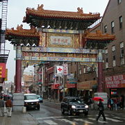
Chinatown
Pennsylvania Convention Center
The Pennsylvania Convention Center is a multi-use public facility in Philadelphia, Pennsylvania which is designed to accommodate conventions, exhibitions, conferences and other events.-History:...
. The Friendship Gate, completed in the winter of 1984, was the first authentic Chinese gate created by artists from China. Today, Chinatown does not only house Chinese, but also Filipinos
Filipino American
Filipino Americans are Americans of Filipino ancestry. Filipino Americans, often shortened to "Fil-Ams", or "Pinoy",Filipinos in what is now the United States were first documented in the 16th century, with small settlements beginning in the 18th century...
, Japanese, Asian Indians, Koreans, Vietnamese
Vietnamese people
The Vietnamese people are an ethnic group originating from present-day northern Vietnam and southern China. They are the majority ethnic group of Vietnam, comprising 86% of the population as of the 1999 census, and are officially known as Kinh to distinguish them from other ethnic groups in Vietnam...
, Cambodians, Hmong
Hmong people
The Hmong , are an Asian ethnic group from the mountainous regions of China, Vietnam, Laos, and Thailand. Hmong are also one of the sub-groups of the Miao ethnicity in southern China...
, Laotians, Thais
Thai people
The Thai people, or Siamese, are the main ethnic group of Thailand and are part of the larger Tai ethnolinguistic peoples found in Thailand and adjacent countries in Southeast Asia as well as southern China. Their language is the Thai language, which is classified as part of the Kradai family of...
and people of other races.
Chinatown has encountered many brushes with community displacement and has fought it off many times with mixed results. In 1992, there was a proposal for a federal prison to be built at 8th and Callowhill Streets in Chinatown. After two years of the Chinatown community fighting it, the plan was thrown out. In the mid- 1960s, the Pennsylvania Department of Transportation
Pennsylvania Department of Transportation
The Pennsylvania Department of Transportation oversees transportation issues in the Commonwealth of Pennsylvania. The administrator of PennDOT is the Pennsylvania Secretary of Transportation, currently Barry Schoch Presently, PennDOT supports over of state roads and highways, about 25,000...
(PennDOT) announced plans to build the Vine Street Expressway. In 1973 PennDOT included the demolition of a building on 10th and Vine Streets and Holy Redeemer Catholic Church. When the demolition crew arrived, they found Chinese youth protesting on the demolition machines. They managed to slow the construction of the Vine Street Expressway, but in the end it was still built. The Gallery shopping mall and the Pennsylvania Convention Center are other completed projects that limit the expansion of Chinatown and which proceeded in spite of community objection. In 2000, there was a proposal to build a baseball stadium in Chinatown. Many of the people in Chinatown felt that the construction of the stadium would negatively impact the community by adding congestion and obnoxious fans, and they felt it would not bring anything positive to the community. Chinatown organizations united to stop the construction of the stadium. There were also plans to open a casino at the Gallery on 8th and Market Streets. Many Philadelphians thought that it would help the city, but the Chinatown community successfully opposed it; the casino will instead be built on the Delaware River waterfront.
East Falls
East Falls is a neighborhood bounded by RoxboroughRoxborough, Philadelphia, Pennsylvania
Roxborough is a neighborhood in the Northwest Philadelphia section of the United States city of Philadelphia, Pennsylvania. It is bordered to the southwest, along the Schuylkill River, by the neighborhood of Manayunk, along the northeast by the Wissahickon Creek section of Fairmount Park, and to...
, Manayunk
Manayunk, Philadelphia, Pennsylvania
Manayunk is a neighborhood in the northwestern section of the city of Philadelphia, Pennsylvania in the United States. Located on the banks of the Schuylkill River, it contains the first canal begun in the United States . The area's name comes from the language of the Lenape Indians...
, Germantown
Germantown, Philadelphia, Pennsylvania
Germantown is a neighborhood in the northwest section of the city of Philadelphia, Pennsylvania, United States, about 7–8 miles northwest from the center of the city...
, and Fairmount Park
Fairmount Park
Fairmount Park is the municipal park system of Philadelphia, Pennsylvania. It consists of 63 parks, with , all overseen by the Philadelphia Department of Parks and Recreation, successor to the Fairmount Park Commission in 2010.-Fairmount Park proper:...
. It was previously a mill town but is now a mix of working and middle-class families. It has academic history as well and is home to the William Penn Charter School, Philadelphia University (founded in 1884 as Philadelphia Textile School and later known as Philadelphia College of Textiles and Science) and the former site of the Medical College of Pennsylvania.
Despite its static nature, there are instances of community transformation in East Falls. Median
Median
In probability theory and statistics, a median is described as the numerical value separating the higher half of a sample, a population, or a probability distribution, from the lower half. The median of a finite list of numbers can be found by arranging all the observations from lowest value to...
house prices are rising, going from $70,000 in 1995 to $202,000 in 2002. East Falls has been viewed as undergoing gentrification, as it’s increasingly inhabited by young professionals. Upscale stores such as a glass blowing shop and The Doggy Boutique, have only added to fears that East Falls will soon cater only to the rich. Change has also come about as a result of the razing of Schuylkill Falls, a high rise public housing facility in an area roughly bounded by the R6 tracks, School House Lane, and Ridge Avenue. The new Hilltop at Falls Ridge public housing contains 304 mixed-income housing units, and is part of a growing development on Ridge Avenue.
A planned community transformation was thwarted, however, when developers proposed locating a casino in the former Budd and Tastykake
Tastykake
Tastykake is the brandname for a line of snack foods manufactured by the Tasty Baking Company, currently headquartered at the Philadelphia Naval Business Center in Philadelphia, Pennsylvania. Established in 1914 by Philip J. Baur and Herbert T...
factory area (2). This plan fell through because of community protests. Proponents of the proposed casino claimed that it would bring more business to East Falls, while the East Falls Community Council argued that crime would increase. In the end, the community won the battle, a testament to the strong character of the neighborhood.
Additionally, Philadelphia University
Philadelphia University
Philadelphia University, founded in 1884, is a private university located in Philadelphia, Pennsylvania, United States. Philadelphia University's student body consists of about 3,500 individuals from all 50 states and over 50 countries...
has tried to expand into the East Falls region. The East Falls Community Council worked with the president of the university to find a way to have the expansion benefit both the college and the community which resulted in several compromises. According to Jennifer Greenfield, the first vice president of the East Falls Community Council, “The university wanted to expand outwards, but now we convinced them to expand upward.” Efforts such as this to maintain the integrity of the neighborhood are evidence that despite evident gentrification and other changes, East Falls will remain the working and middle-class neighborhood that it is today.
Society Hill
Society Hill, Philadelphia, Pennsylvania
Society Hill is a neighborhood in the Center City section of Philadelphia, Pennsylvania, United States. The neighborhood, loosely defined as bounded by Walnut, Lombard, Front and 7th Streets, contains the largest concentration of original 18th- and early 19th-century architecture of any place in...
began as an affluent neighborhood in Southeast Philadelphia close to the Delaware River
Delaware River
The Delaware River is a major river on the Atlantic coast of the United States.A Dutch expedition led by Henry Hudson in 1609 first mapped the river. The river was christened the South River in the New Netherland colony that followed, in contrast to the North River, as the Hudson River was then...
and civic buildings like Independence Hall
Independence Hall
Independence Hall is the centerpiece of Independence National Historical Park located in Philadelphia, Pennsylvania, United States, on Chestnut Street between 5th and 6th Streets...
. The name originates from The Free Society of Traders, a London based development company that was granted land from William Penn
William Penn
William Penn was an English real estate entrepreneur, philosopher, and founder of the Province of Pennsylvania, the English North American colony and the future Commonwealth of Pennsylvania. He was an early champion of democracy and religious freedom, notable for his good relations and successful...
. It is bordered by Front, Lombard, 8th and Walnut Streets. In the 19th century, the area lost appeal as the city's main commercial district moved west and the affluent residents moved closer to Center City or to areas like Chestnut Hill
Chestnut Hill, Philadelphia, Pennsylvania
Chestnut Hill is a neighborhood in the Northwest Philadelphia section of the United States city of Philadelphia, Pennsylvania.-Boundaries:Chestnut Hill is bounded as follows:...
and the Main Line. The neighborhood then became an African American community centered around the Mother Bethel Church at 6th and Lombard. W.E.B. Du Bois
W.E.B. Du Bois
William Edward Burghardt Du Bois was an American sociologist, historian, civil rights activist, Pan-Africanist, author, and editor. Born in Massachusetts, Du Bois attended Harvard, where he was the first African American to earn a doctorate...
studied the neighborhood in the late 19th and early 20th centuries as an employee of the University of Pennsylvania
University of Pennsylvania
The University of Pennsylvania is a private, Ivy League university located in Philadelphia, Pennsylvania, United States. Penn is the fourth-oldest institution of higher education in the United States,Penn is the fourth-oldest using the founding dates claimed by each institution...
. In his groundbreaking work of urban sociology, The Philadelphia Negro, DuBois documented the awful conditions of the neighborhood: "We lived there for a year, in the midst of an atmosphere of dirt, drunkenness, poverty, and crime. Murder sat at our doorsteps, police were our government..." W.E.B. DuBois studied the 7th Ward, which only includes roughly two blocks of what is today known as Society Hill. Also, US Census data shows that Society Hill in 1940 (census tract 10) was a racially mixed area and quite consistent with the rest of Philadelphia. The houses deteriorated until the 1950s.
In 1948, Edmund Bacon, head of the Philadelphia City Planning Commission, created plans to “redevelop” Society Hill. In 1956, the Old Philadelphia Development Corporation joined the Philadelphia Redevelopment Authority
Philadelphia Redevelopment Authority
The Philadelphia Redevelopment Authority, with the legal name of "Redevelopment Authority of the City of Philadelphia", was created by the Commonwealth of Pennsylvania's Urban Redevelopment Law of 1945...
(RDA) in the effort. In the 1950s, the RDA acquired 31 acres (125,452.7 m²) of land in the Dock Street area by declaring it "blighted". They designed standards of restoration for historic property. In 1960, owners were forced to renovate their houses or their property would be declared blighted and the RDA would use eminent domain to obtain the property. Residents of these “blighted” homes were often forced out, for a variety of reasons. Some residents could not pay for the renovation of their houses, others were renters, and their landlords would not pay. In either case, the RDA, through blight declaration, bought out many African American residents and sold the houses to people who agreed to restore the exteriors, virtually all of whom were white.
High-rise towers designed by I.M. Pei were built in 1962 on the periphery of the neighborhood. The purpose of the Society Hill Towers was to attract a substantial number of affluent residents to the area and to encourage others to move into Society Hill to renovate old houses or construct new ones. As redevelopment continued, the neighborhood became more desirable and demand for real estate ballooned. The increase in demand led the RDA to acquire 58 more acres of land for revitalization.
Currently, the area known as Society Hill is home to a plurality of young, white, affluent singles. Those living in the area take pride in the colonial heritage of the neighborhood which has been meticulously documented. The 19th and early to mid-20th century history of the neighborhood has largely been forgotten. It is an attractive neighborhood for its historic housing stock as well as its proximity to the Center City commercial district and to Old City shops and restaurants.
Riverfront
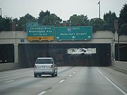
Interstate 95
Interstate 95 is the main highway on the East Coast of the United States, running parallel to the Atlantic Ocean from Maine to Florida and serving some of the most populated urban areas in the country, including Boston, Providence, New Haven, New York City, Newark, Philadelphia, Baltimore,...
was being constructed in various sections of Pennsylvania. The first part to open in Philadelphia was in Northeast Philadelphia. Work continued, moving southward from the Northeast. There was much controversy, however, over the central portion of the highway, through Center City and its adjacent riverfront neighborhoods. A 1959 plan called for an eight-lane elevated highway along the Delaware River waterfront, with the demolition of blighted buildings in the name of "urban renewal" an intentional part of the plan. Numerous citizens, city officials, and architects raised objections to the plan. The design was changed to put the highway below ground level, open to the air above. One proposal involved covering the highway from Pine Street to Arch Street, but this was later reduced in the final design to two smaller cover decks, with the rest still open to the air above. The downtown portion of the highway was constructed, and eventually opened in 1979.
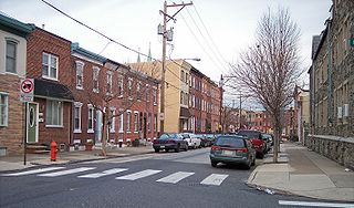
In the neighborhood of Queen Village, the construction of the highway involved the destruction of hundreds of homes and businesses, including over 300 houses built in the 18th century, and the displacement of their respective residents and owners. It also created a major barrier between residential neighborhoods and the Delaware River.
Queen Village resident Marty Labb described the destruction in a publication by the Queen Village Neighborhood Association: “I-95 almost destroyed the neighborhood because it took an awful lot of homes away. There were a lot of homes on the east side of Front Street, between Washington Avenue and Christian and Queen Street, and they went down because of the highway. ... Someone called me up. They said, 'They’re taking your house. They’re gonna rip it down because they’re putting a highway in there.' That went by the wayside, but that was one of the original plans...."
In the neighborhood of Fishtown, too, the construction of I-95 involved the bulldozing of many blocks of homes near the waterfront.
In the present day, many of the neighborhoods along the waterfront are stable and successful. Despite this, though, the homes that were destroyed were lost forever. Also, the highway continues to separate the city from the waterfront, and is a blighting influence on the streets directly beneath or adjacent to it.
Fishtown
Fishtown, Philadelphia, Pennsylvania
Fishtown is a neighborhood in Philadelphia, Pennsylvania, United States. Located immediately northeast of Center City, its borders are somewhat disputed today due to many factors, but are roughly defined by the triangle created by the Delaware River, Frankford Avenue, and York Street...
, also known as Lower Kensington, is part of Philadelphia’s Kensington section. Local folklore says that Charles Dickens
Charles Dickens
Charles John Huffam Dickens was an English novelist, generally considered the greatest of the Victorian period. Dickens enjoyed a wider popularity and fame than had any previous author during his lifetime, and he remains popular, having been responsible for some of English literature's most iconic...
gave Fishtown its name, but this has been dispelled as a myth because there is no record of Charles Dickens ever visiting the area. The name comes from the large amount of sea-faring businesses that were present in the area during the 18th and 19th centuries: shipbuilding
Shipbuilding
Shipbuilding is the construction of ships and floating vessels. It normally takes place in a specialized facility known as a shipyard. Shipbuilders, also called shipwrights, follow a specialized occupation that traces its roots to before recorded history.Shipbuilding and ship repairs, both...
factories, fisheries, and ice houses.
Fishtown is located on the Delaware River
Delaware River
The Delaware River is a major river on the Atlantic coast of the United States.A Dutch expedition led by Henry Hudson in 1609 first mapped the river. The river was christened the South River in the New Netherland colony that followed, in contrast to the North River, as the Hudson River was then...
. To the southwest of Fishtown are Old City, Center City, and Northern Liberties; to the west, there is Poplar and Yorktown, and to the North is Kensington. In the past, the neighborhood was made up mainly of working class families—traditionally German
Germans
The Germans are a Germanic ethnic group native to Central Europe. The English term Germans has referred to the German-speaking population of the Holy Roman Empire since the Late Middle Ages....
, Polish
Poles
thumb|right|180px|The state flag of [[Poland]] as used by Polish government and diplomatic authoritiesThe Polish people, or Poles , are a nation indigenous to Poland. They are united by the Polish language, which belongs to the historical Lechitic subgroup of West Slavic languages of Central Europe...
, and Irish. Since the neighborhood is in such close proximity to other high income gentrified neighborhoods of the city – Northern Liberties and Old City – the hipster culture has recently spread into the surrounding area of Fishtown. Artists, musicians, and young professionals have been drawn to the area, and they are rapidly buying up properties. Due to the large population of older people, many homes that had been passed down from generation to generation are being sold by the children as the parents die off. The nightlife and art scene, resulting from the growing population of "hipsters", creates a new and young atmosphere in the neighborhood. This change in the make-up and character of the neighborhood attracts more people of the same relatively young and affluent demographic, thus reinforcing the process of gentrification
Gentrification
Gentrification and urban gentrification refer to the changes that result when wealthier people acquire or rent property in low income and working class communities. Urban gentrification is associated with movement. Consequent to gentrification, the average income increases and average family size...
.
Due to the widespread availability of housing and the high rate of home ownership, there have not been many people displaced by the gentrification of Fishtown. In the past eight years, however, the housing values have more than doubled. There have been some tensions and conflicts between the locals and the new, young residents, but many long-time inhabitants seem to welcome influx of high-income people who bring better resources and culture. As one Fishtown resident said: “If I had to choose between folks who frequent a crack house and those who can afford a Starbucks on a regular basis, I'm not sure who I'd pick”4 . The Rocket Cat Café, on the corner of Frankford Ave and Norris St, is one example of the new “hipster” vibe present in the neighborhood.
Fairmount
Fairmount is a neighborhood in Philadelphia located north of Center City and south of Girard AvenueGirard Avenue
Girard Avenue is a major east-west thoroughfare in Philadelphia that forms sections of U.S. Route 13 and U.S. Route 30 and is named for Franco-American financier Stephen Girard. It stretches through several major neighborhoods of Philadelphia, including West Philadelphia, Fishtown, Kensington, and...
. The neighborhood extends from the Schuylkill River
Schuylkill River
The Schuylkill River is a river in Pennsylvania. It is a designated Pennsylvania Scenic River.The river is about long. Its watershed of about lies entirely within the state of Pennsylvania. The source of its eastern branch is in the Appalachian Mountains at Tuscarora Springs, near Tamaqua in...
to 20th Street. The area was first settled in the 17th and 18th centuries by farmers from varied parts of Europe. It was a popular a spot for prominent families to put their summer homes and is also the location of several significant sites. In 1829, the Eastern State Penitentiary
Eastern State Penitentiary
The Eastern State Penitentiary is a former American prison in Philadelphia, Pennsylvania. It is located on 2027 Fairmount Avenue between Corinthian Avenue and North 22nd Street in the Fairmount section of Philadelphia and was operational from 1829 until 1971...
was opened. It was the first prison that focused on reform rather than punishment. In 1831 Girard College
Girard College
Girard College is an independent boarding school on a 43-acre campus in Philadelphia, Pennsylvania, in the United States.Girard is for academically capable students, grades one through 12, and awards a full scholarship with a yearly value of approximately $42,000 to every child admitted to the...
was built. It was founded by Stephen Girard
Stephen Girard
Stephen Girard was a French-born, naturalized American, philanthropist and banker. He personally saved the U.S. government from financial collapse during the War of 1812, and became one of the wealthiest men in America, estimated to have been the fourth richest American of all time, based on the...
, the wealthiest man in America at the time, for white, orphaned boys. In 1839 St. Francis Church was built, but during the anti-Catholic/Irish riots of 1844 the church was closed. Then, in 1852 the Fairmount Dam and Waterworks
WaterWorks
WaterWorks is a water park owned by Cedar Fair, located at the back of Kings Dominion in Doswell, Virginia. When it debuted in 1992, it was originally named Hurricane Reef...
was built.
During the 19th century, Irish and German
Germans
The Germans are a Germanic ethnic group native to Central Europe. The English term Germans has referred to the German-speaking population of the Holy Roman Empire since the Late Middle Ages....
immigrants made up most of the neighborhood's population. In the early 20th century Polish
Poles
thumb|right|180px|The state flag of [[Poland]] as used by Polish government and diplomatic authoritiesThe Polish people, or Poles , are a nation indigenous to Poland. They are united by the Polish language, which belongs to the historical Lechitic subgroup of West Slavic languages of Central Europe...
and Ukrainian immigrants also began coming to Fairmount.
The Fairmount neighborhood changed dramatically after the 1940s and 1950s. The Girard Avenue
Girard Avenue
Girard Avenue is a major east-west thoroughfare in Philadelphia that forms sections of U.S. Route 13 and U.S. Route 30 and is named for Franco-American financier Stephen Girard. It stretches through several major neighborhoods of Philadelphia, including West Philadelphia, Fishtown, Kensington, and...
shopping area was destroyed by riots in the early 1960s, and it’s never been built up again. Also, the residents of Fairmount experienced the hardships of deindustrialization; factories closed and poverty and crime increased. The demographics of the area changed as many white residents moved to suburban areas, and parts of the neighborhood became predominantly African-American or Hispanic
Hispanic
Hispanic is a term that originally denoted a relationship to Hispania, which is to say the Iberian Peninsula: Andorra, Gibraltar, Portugal and Spain. During the Modern Era, Hispanic sometimes takes on a more limited meaning, particularly in the United States, where the term means a person of ...
.
The addition of upscale town homes in the 1980s and 1990s caused displacement of longtime residents as people, in particular the younger generations, moved away from Fairmount when they could no longer afford to live there. The real estate boom began to draw many affluent white people back from the suburbs to neighborhoods like Fairmount. Members of the community have worked diligently to preserve and improve their surroundings. The neighborhood remains largely white, but it continues to become gentrified. Younger professional families, students, and singles are moving in. The attraction for most is its proximity to Center City, Fairmount Park
Fairmount Park
Fairmount Park is the municipal park system of Philadelphia, Pennsylvania. It consists of 63 parks, with , all overseen by the Philadelphia Department of Parks and Recreation, successor to the Fairmount Park Commission in 2010.-Fairmount Park proper:...
, and the Philadelphia Museum of Art
Philadelphia Museum of Art
The Philadelphia Museum of Art is among the largest art museums in the United States. It is located at the west end of the Benjamin Franklin Parkway in Philadelphia's Fairmount Park. The Museum was established in 1876 in conjunction with the Centennial Exposition of the same year...
.
South Street West
South Street West, located in the southwest corner of Center City and also known as the Graduate HospitalGraduate Hospital
Graduate Hospital was a hospital in the Southwest Center City neighborhood of Philadelphia, founded in 1916 and repurposed in 2007. Medical care began on the site in 1889 under the name Philadelphia Polyclinic. Currently, the site is a rehabilitation and long-term acute-care facility known as...
area, was planned by William Penn
William Penn
William Penn was an English real estate entrepreneur, philosopher, and founder of the Province of Pennsylvania, the English North American colony and the future Commonwealth of Pennsylvania. He was an early champion of democracy and religious freedom, notable for his good relations and successful...
to be the southernmost border of Philadelphia. From the time that settlement in the area began around 1600, it was primarily an immigrant neighborhood and eventually became a thriving African American commercial and entertainment district. In 1947, the Philadelphia City Planning Commission proposed the Crosstown Expressway, a multi-lane highway across the city along the blocks between South Street and Lombard Street. This project would have effectively separated the different “land usages” to the north and south, which would have been, in essence, separating racial groups. The project would have also uprooted several thousands of people from homes they had owned for years, if not generations.
Fearing that their homes would be confiscated through use of eminent domain, many residents sold their homes and left the area, while others stayed to fight back. The Citizens’ Committee to Preserve and Develop the Crosstown Community (CCPDCC), was formed in opposition to the expressway and was composed mostly of white residents from the Society Hill and Rittenhouse Square areas, as well as the black residents along the path of the planned expressway. As a result of this opposition, the plans for the expressway ultimately fell through, leaving the area full of abandoned property.
With the neighborhood weakened and vulnerable, Graduate Hospital, an established hospital on the edge of the neighborhood, took advantage of the cheap, abandoned property and expanded through a process of buying properties and letting them deteriorate to bring other property values down. As people moved out of the declining neighborhood, Graduate Hospital bought more of the abandoned property until it could build a new hospital building. The hospital provided necessary services, however, they did not confine their expansion to sections of the neighborhood approved during negotiations with the community. Several community organizations banded together and, though there was some displacement, residents and local merchants were able to maintain their neighborhood. Recently, due to the spread of the upscale businesses and residences of Center City toward western South Street, property values have risen, and there has been further displacement of lower income, mostly minority, inhabitants. The former Graduate Hospital is now Penn Medicine at Rittenhouse
Rittenhouse
-People with Rittenhouse surname:*Ariel Rittenhouse , US female athlete in swimming and diving*David Rittenhouse , US astronomer, inventor, mathematician, and public official*Moses F...
, a rehabilitation and acute-care facility owned owned by University of Pennsylvania Health System
University of Pennsylvania Health System
The University of Pennsylvania Health System is a diverse research and clinical care organization in Philadelphia, Pennsylvania. Founded in 1993, it currently operates under the direction and auspices of Penn Medicine, a division of the University of Pennsylvania...
.
University City
Displacement in University CityUniversity City, Philadelphia, Pennsylvania
University City is the easternmost region of West Philadelphia.The University of Pennsylvania has long been the dominant institution in the area and was instrumental in coining the name University City as part of a 1950s urban-renewal effort...
has mainly been caused by the expansion of local institutions, most prominently the University of Pennsylvania
University of Pennsylvania
The University of Pennsylvania is a private, Ivy League university located in Philadelphia, Pennsylvania, United States. Penn is the fourth-oldest institution of higher education in the United States,Penn is the fourth-oldest using the founding dates claimed by each institution...
. After moving to West Philadelphia 1872, Penn was faced with a massive influx of students after World War II as a result of the GI Bill. The university's first significant expansion into the community was done with the aid of the federal slum clearance program. Areas around the university were designated as blighted, and the use of eminent domain cleared the way for developing the land.
Around this time, the Housing Act of 1949
Housing Act of 1949
The American Housing Act of 1949 was a landmark, sweeping expansion of the federal role in mortgage insurance and issuance and the construction of public housing...
allowed Penn to rebuild West Philadelphia, with the help of federal aid. Families were forced to leave their homes, in the name of urban renewal. An exact number of the people displaced isn't known, but figures range from 5,000 – 10,000. Soon after that, the West Philadelphia Corporation, consisting of Penn, Drexel University
Drexel University
Drexel University is a private research university with the main campus located in Philadelphia, Pennsylvania, USA. It was founded in 1891 by Anthony J. Drexel, a noted financier and philanthropist. Drexel offers 70 full-time undergraduate programs and accelerated degrees...
, Philadelphia College of Pharmacy and Science, Presbyterian Hospital, and the College of Osteopathy worked together to build the University City Science Center. An earlier Housing Act would give the institutions generous grants to building academic centers, and soon enough, West Philadelphia became Urban Renewal Areas 3, 4, and 5. Area 3 consisted mainly of the Black Bottom neighborhood, and while described by newspapers as "20 devastated acres of rundown bars and garages and warehouses," it was still home to hundreds of families who soon found themselves without a home.
In more recent years, Penn has attempted to bring their professors closer to the university, and back into the city. As part of Penn's effort to have the university integrated into West Philadelphia, Penn has sponsored a program to make their professors residents of nearby neighborhoods. The university has instituted the Home Ownership Incentive Program that provides $3,000 per year for seven years or $15,000 up front for housing expenses to employees who purchase homes in University City. The only restriction is that the employees must live in the house for seven years. The employees who already own a home in the designated area get up to $7,500 in matching funds toward exterior home improvements. This has been in effect since 1965, when it created the Guaranteed Mortgage Program, which offers an option to finance 120 percent of the cost for a property needing rehabilitation.
As another incentive, the university helped to build Penn Alexander Elementary School, a state-of-the-art K-8 school designed to make the neighborhood even more attractive to professors and other affluent residents. However, the school only accepts students who live within a certain radius, and alienates many of the poorer residents in University City. However, this wasn't the only school Penn had a hand in building. In 1963, University City High School was planned as a magnet feeder school for the universities in the area. Residents in the community fought against it, not believing that their children would be allowed in. After countless battles, the school was built, and is now predominantly African American and is afflicted with the problems typical of an inner-city high school.
The University of Pennsylvania, with the help of the government, has been able to exert its power under the pretense of eminent domain and urban renewal. The stated intentions of their programs are to collaborate with the community of West Philadelphia, and work towards the common goal of an attractive and safe neighborhood. The effect has yet to be seen, and many residents in the area dislike the "Penn Bubble" that continues to expand. The University of Pennsylvania has grown multiple times since their move to West Philadelphia, and many residents have been displaced as a result.
Hawthorne

Philadelphia High School for Creative and Performing Arts
The Philadelphia High School for Creative and Performing Arts is a magnet school in Philadelphia, Pennsylvania. Students major in one of six areas: Creative Writing, Instrumental Music, Visual Arts, Theater, Dance, and Vocal Music...
).
One of the neighborhood’s most notable landmarks was the Martin Luther King Plaza, which included a complex of four low-income housing high-rise towers constructed in 1960. The MLK towers were located in the 700 block of South 13th Street and quickly became riddled with crime, physical deterioration, fragmented services, and increasing levels of poverty.
On October 17, 1999, the building was demolished and was replaced by a residential development with mixed income housing funded through HOPE VI, an initiative of the Department of Housing and Urban Development (HUD). The construction of the new homes was completed in the end of 2004. This new housing became an integral part of the neighborhood; it wasn't a separate entity as the MLK towers had been. The development is equipped with a park and recreation center, as well as support services to help residents get and keep jobs. The neighborhood also has mixed raced committees organized to keep the area clean and make it more welcoming and beneficial to the community’s users.
Despite the positive results of the initiative’s efforts, it ultimately led to significant community displacement. The former residents of the MLK towers were dispersed during the construction. In addition, the amount of residential space was reduced after the redevelopment, and the vast majority of former residents could not afford to move into and sustain a living in the new MLK complex. This has ultimately changed the demographic of the neighborhood; prior to the government intervention and development provided by Hope VI, the neighborhood was predominantly African American, however, since federal intervention the community is 67% White, 12% Black, 15% Asian
Asian people
Asian people or Asiatic people is a term with multiple meanings that refers to people who descend from a portion of Asia's population.- Central Asia :...
, and 6% Latino.