
Columbia Bar
Encyclopedia
The Columbia Bar is a system of bars
and shoal
s at the mouth of the Columbia River
spanning the US states of Oregon
and Washington. The bar is about 3 miles (4.8 km) wide and 6 miles (9.7 km) long.
The bar is where the river's current dissipates into the Pacific Ocean
, often as large standing waves. The waves are partially caused by the deposition of sediment as the river slows, as well as mixing with ocean waves. The waves, wind, and current are hazardous for vessels of all sizes. The Columbia current varies from 4 to 7 knots westward, and therefore into the predominantly westerly winds and ocean swells, creating significant surface conditions.
Unlike other major rivers, the current is focused "like a fire hose" without the benefit of a river delta
.
Conditions can change from calm to life-threatening in as little as five minutes due to changes of direction of wind and ocean swell.
Since 1792, approximately 2,000 large ships have sunk in and around the Columbia Bar.
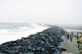
The navigational channel is 2640 feet (804.7 m) wide at the west end and narrows to 600 feet (182.9 m) within the jetties. The channel is dredged to 55 feet (16.8 m) in the northern three-quarters and 48 feet (14.6 m) for the southern quarter. Inside the bar, the channel remains 600 feet (182.9 m) wide and reduces to 43 feet (13.1 m) deep.
The nearby United States Coast Guard Station Cape Disappointment
, Washington is renowned for operating in some of the roughest sea conditions in the world, and is home to the National Motor Lifeboat School. It is the only school for rough weather and surf rescue operation in the US, and is respected internationally as a center of excellence for heavy boat operations.
Approximately 16 bar pilots
, earning about $180,000 per year, guide ships across the bar, often boarding ships by helicopter.
They generally consider "the bar" to be the area between the north and south jetties
and Sand Island.
The Columbia Bar is part of a set of major marine coastal hazards along the Pacific Northwest
coast, including Cape Flattery at the northwest tip of the Olympic Peninsula
and Cape Scott
, which is at the north tip of Vancouver Island
. Historically the region's mariner's nickname was the Graveyard of the Pacific
, and it is studded with thousands of shipwrecks. The "Graveyard" also includes the rocky, rugged shoreline of the west coast of Vancouver Island, the shores of the Olympic Peninsula, and the Strait of Juan de Fuca
.
As a practical tip, small craft are advised to cross the bar during the incoming flood tide, staying toward the outside of the navigational channel to avoid large ships which move at 20 to 30 knots.
. For a more dramatic view, hike the steep 0.75 mile trail to the Cape Disappointment Lighthouse
at the Cape Disappointment State Park located in Ilwaco, Washington
.
Bar (landform)
A shoal, sandbar , or gravelbar is a somewhat linear landform within or extending into a body of water, typically composed of sand, silt or small pebbles. A spit or sandspit is a type of shoal...
and shoal
Shoal
Shoal, shoals or shoaling may mean:* Shoal, a sandbank or reef creating shallow water, especially where it forms a hazard to shipping* Shoal draught , of a boat with shallow draught which can pass over some shoals: see Draft...
s at the mouth of the Columbia River
Columbia River
The Columbia River is the largest river in the Pacific Northwest region of North America. The river rises in the Rocky Mountains of British Columbia, Canada, flows northwest and then south into the U.S. state of Washington, then turns west to form most of the border between Washington and the state...
spanning the US states of Oregon
Oregon
Oregon is a state in the Pacific Northwest region of the United States. It is located on the Pacific coast, with Washington to the north, California to the south, Nevada on the southeast and Idaho to the east. The Columbia and Snake rivers delineate much of Oregon's northern and eastern...
and Washington. The bar is about 3 miles (4.8 km) wide and 6 miles (9.7 km) long.
The bar is where the river's current dissipates into the Pacific Ocean
Pacific Ocean
The Pacific Ocean is the largest of the Earth's oceanic divisions. It extends from the Arctic in the north to the Southern Ocean in the south, bounded by Asia and Australia in the west, and the Americas in the east.At 165.2 million square kilometres in area, this largest division of the World...
, often as large standing waves. The waves are partially caused by the deposition of sediment as the river slows, as well as mixing with ocean waves. The waves, wind, and current are hazardous for vessels of all sizes. The Columbia current varies from 4 to 7 knots westward, and therefore into the predominantly westerly winds and ocean swells, creating significant surface conditions.
Unlike other major rivers, the current is focused "like a fire hose" without the benefit of a river delta
River delta
A delta is a landform that is formed at the mouth of a river where that river flows into an ocean, sea, estuary, lake, reservoir, flat arid area, or another river. Deltas are formed from the deposition of the sediment carried by the river as the flow leaves the mouth of the river...
.
Conditions can change from calm to life-threatening in as little as five minutes due to changes of direction of wind and ocean swell.
Since 1792, approximately 2,000 large ships have sunk in and around the Columbia Bar.
The navigational channel is 2640 feet (804.7 m) wide at the west end and narrows to 600 feet (182.9 m) within the jetties. The channel is dredged to 55 feet (16.8 m) in the northern three-quarters and 48 feet (14.6 m) for the southern quarter. Inside the bar, the channel remains 600 feet (182.9 m) wide and reduces to 43 feet (13.1 m) deep.
The nearby United States Coast Guard Station Cape Disappointment
Coast Guard Station Cape Disappointment
United States Coast Guard Station Cape Disappointment, situated near Cape Disappointment, Washington at the mouth of the Columbia River, is the largest United States Coast Guard search and rescue station on the Northwest Coast, with 50 crewmembers assigned. Cape Disappointment Station is also the...
, Washington is renowned for operating in some of the roughest sea conditions in the world, and is home to the National Motor Lifeboat School. It is the only school for rough weather and surf rescue operation in the US, and is respected internationally as a center of excellence for heavy boat operations.
Approximately 16 bar pilots
Maritime pilot
A pilot is a mariner who guides ships through dangerous or congested waters, such as harbours or river mouths. With the exception of the Panama Canal, the pilot is only an advisor, as the captain remains in legal, overriding command of the vessel....
, earning about $180,000 per year, guide ships across the bar, often boarding ships by helicopter.
They generally consider "the bar" to be the area between the north and south jetties
Jetty
A jetty is any of a variety of structures used in river, dock, and maritime works that are generally carried out in pairs from river banks, or in continuation of river channels at their outlets into deep water; or out into docks, and outside their entrances; or for forming basins along the...
and Sand Island.
The Columbia Bar is part of a set of major marine coastal hazards along the Pacific Northwest
Pacific Northwest
The Pacific Northwest is a region in northwestern North America, bounded by the Pacific Ocean to the west and, loosely, by the Rocky Mountains on the east. Definitions of the region vary and there is no commonly agreed upon boundary, even among Pacific Northwesterners. A common concept of the...
coast, including Cape Flattery at the northwest tip of the Olympic Peninsula
Olympic Peninsula
The Olympic Peninsula is the large arm of land in western Washington state of the USA, that lies across Puget Sound from Seattle. It is bounded on the west by the Pacific Ocean, the north by the Strait of Juan de Fuca, and the east by Puget Sound. Cape Alava, the westernmost point in the contiguous...
and Cape Scott
Cape Scott
Cape Scott is a cape at the western side of the terminus of Dennistoun Glacier on the northern coast of Victoria Land in Antarctica. Discovered by Captain James Ross, 1841, who named it for Peter A. Scott, Mate on the Terror....
, which is at the north tip of Vancouver Island
Vancouver Island
Vancouver Island is a large island in British Columbia, Canada. It is one of several North American locations named after George Vancouver, the British Royal Navy officer who explored the Pacific Northwest coast of North America between 1791 and 1794...
. Historically the region's mariner's nickname was the Graveyard of the Pacific
Graveyard of the Pacific
The Graveyard of the Pacific is a nickname for a stretch of the coastal region in the Pacific Northwest, from Tillamook Bay on the Oregon Coast northward to the tip of Vancouver Island...
, and it is studded with thousands of shipwrecks. The "Graveyard" also includes the rocky, rugged shoreline of the west coast of Vancouver Island, the shores of the Olympic Peninsula, and the Strait of Juan de Fuca
Strait of Juan de Fuca
The Strait of Juan de Fuca is a large body of water about long that is the Salish Sea outlet to the Pacific Ocean...
.
As a practical tip, small craft are advised to cross the bar during the incoming flood tide, staying toward the outside of the navigational channel to avoid large ships which move at 20 to 30 knots.
Viewing
The most accessible place to watch ships cross the bar is at the South Jetty viewing platform at Fort Stevens State Park located near Hammond, Oregon. This is also the north end of the Oregon Coast TrailOregon Coast Trail
The Oregon Coast Trail is a long-distance hiking route along the Pacific coast of Oregon in the United States. It follows the coast of Oregon from the mouth of the Columbia River to the California border south of Brookings....
. For a more dramatic view, hike the steep 0.75 mile trail to the Cape Disappointment Lighthouse
Cape Disappointment Lighthouse
The Cape Disappointment Light is a lighthouse on Cape Disappointment near the mouth of the Columbia River in the U.S. state of Washington.- History :...
at the Cape Disappointment State Park located in Ilwaco, Washington
Ilwaco, Washington
Ilwaco is a city in Pacific County, Washington, United States. The population was 950 at the 2000 census and decreased to 936 at the 2010 census.-History:...
.
See also
- King & WingeKing & Winge (fishing schooner)The King & Winge was one of the most famous ships ever built in Seattle, Washington, United States. Built in 1914, in the next 80 years she had participated in a famous Arctic rescue, been present at a great maritime tragedy, and been employed as a halibut schooner, a rum runner, a pilot boat, a...
(bar pilot boat from 1924 to 1958) - ColumbiaLightship ColumbiaUnited States lightship Columbia is a lightship located in Astoria, Oregon, United States of America. The Columbia was formerly moored near the mouth of the Columbia River.-History:...
, historic navigational aid into the Columbia River - RabboniRabboni (steam tug)Rabboni was a steam tug that operated on the west coast of the United States starting in 1865.- Career:Rabboni was built in San Francisco, California, and launched on April 9, 1865. The tug was brought north to the mouth of the Columbia river, arriving in July 1865, and reaching Portland, Oregon...
, first regular steam tug to bring a ship across the Columbia bar.